
Skiing is the use of skis to glide on snow. Variations of purpose include basic transport, a recreational activity, or a competitive winter sport. Many types of competitive skiing events are recognized by the International Olympic Committee (IOC), and the International Ski Federation (FIS).
Alpine skiing, or downhill skiing, is the pastime of sliding down snow-covered slopes on skis with fixed-heel bindings, unlike other types of skiing, which use skis with free-heel bindings. Whether for recreation or for sport, it is typically practiced at ski resorts, which provide such services as ski lifts, artificial snow making, snow grooming, restaurants, and ski patrol.
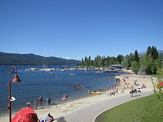
McCall is a resort town on the western edge of Valley County, Idaho, United States. Named after its founder, Tom McCall, it is situated on the southern shore of Payette Lake, near the center of the Payette National Forest. The population was 2,991 as of the 2010 census, up from 2,084 in 2000.

Bogus Basin Mountain Recreation Area is a ski area in the western United States, located in southwest Idaho in Boise County, sixteen road miles (26 km) north-northeast of the city of Boise.
Corey Engen was the captain of the U.S. Nordic ski team at the 1948 Winter Olympics in St. Moritz, Switzerland. He was the youngest of the three Engen brothers that pioneered and popularized alpine skiing in the intermountain west, primarily in Utah and Idaho.
Brundage Mountain Resort is an alpine ski area in the western United States, located in west central Idaho in the Payette National Forest. Brundage first opened in November 1961 and is eight miles (13 km) northwest of McCall, a twenty-minute drive in average winter conditions.
Kelly Canyon is an alpine ski area in eastern Idaho, in the Targhee National Forest. Northeast of Idaho Falls, it straddles the county line in the southeastern corner of Jefferson County and also in southern Madison County. The ski area opened in 1957, founded by E. Bud Johnson.
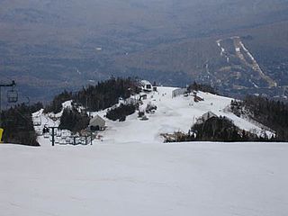
Waterville Valley is a ski resort in Waterville Valley, New Hampshire, United States. It is located within the White Mountain National Forest. Built on Mount Tecumseh, with a summit elevation of 3,997 feet (1,218 m) above sea level, the ski trails extend to a high point on the south ridge of the mountain at 3,840 feet (1,170 m), offering a vertical drop of 2,020 feet (615 m). The ski area has 11 lifts, including two high-speed quads and the slopes primarily face east and northeast.
Lost Valley is a ski area in the northeastern United States, in Auburn, Maine. Its east-facing slopes feature 21 trails & 9 gladed trails across the hill, and is served by four lifts two chairlifts, one ground lift carpet & one tow lift in their snowtubing park. Lost Valley is home to the Maine Family Snow Tube Park.
State Highway 55 (SH-55) is an Idaho highway from Marsing to New Meadows, connecting with US-95 at both ends.
The following outline is provided as an overview of and topical guide to skiing:

Snoqualmie Pass is a mountain pass that carries Interstate 90 (I-90) through the Cascade Range in the U.S. state of Washington. The pass summit is at an elevation of 3,015 feet (919 m), on the county line between Kittitas County and King County.
Snowhaven is a modest ski area in the western United States, located in north central Idaho, seven miles (11 km) southeast of Grangeville in Idaho County. The elevation of its summit is 5,600 feet (1,707 m) above sea level, with a vertical drop of 400 feet (122 m) on east-facing slopes.
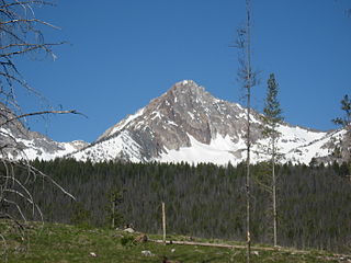
Williams Peak, at 10,636 feet (3,242 m) high is the 6th highest peak in the Sawtooth Mountains of Idaho and is located within the Sawtooth Wilderness portion of the Sawtooth National Recreation Area. The peak lies 0.75 mi (1,210 m) north-northeast of Thompson Peak, the highest peak in the range.
North–South Ski Bowl was a modest ski area in the western United States, located in northern Idaho in the Hoodoo Mountains of southern Benewah County.
Patricia "Patty" Boydstun (-Hovdey) is a former World Cup alpine ski racer from the United States.

Mount Sniktau is a high mountain summit in the Front Range of the Rocky Mountains of North America. The 13,240-foot (4,036 m) thirteener is located in Arapaho National Forest, 1.6 miles (2.5 km) northeast of Loveland Pass in Clear Creek County, Colorado, United States.

The 1966 NCAA Skiing Championships were contested at the Crested Butte ski area in Created Butte, Colorado at the thirteenth annual NCAA-sanctioned ski tournament to determine the individual and team national champions of men's collegiate alpine skiing, cross-country skiing, and ski jumping in the United States.
This glossary of skiing and snowboarding terms is a list of definitions of terms and jargon used in skiing, snowboarding, and related winter sports.

