
Alameda County is located in the state of California in the United States. As of the 2010 census, the population was 1,510,271, making it the 7th-most populous county in the state and 20th most populous nationally. The county seat is Oakland. Alameda County is in the San Francisco Bay Area, occupying much of the East Bay region.

Livermore is a city in Alameda County, California, in the United States. With an estimated 2019 population of 90,189, Livermore is the most populous city in the Tri-Valley. Livermore is located on the eastern edge of California's San Francisco Bay Area. The current mayor is Bob Woerner.

Pleasanton is a city in Alameda County, California. Located in the Amador Valley, it is a suburb in the East Bay region of the Bay Area. The population was 70,285 at the 2010 census. In 2005 and 2007, Pleasanton was ranked the wealthiest middle-sized city in the United States by the Census Bureau. Pleasanton is home to the headquarters of Safeway, Workday, Ellie Mae, Roche Molecular Diagnostics, Blackhawk Network Holdings, and Veeva Systems. Other major employers include Kaiser Permanente, Oracle and Macy's. Although Oakland is the Alameda County seat, a few county offices are located in Pleasanton. The Alameda County Fairgrounds are located in Pleasanton, where the county fair is held during the last week of June and the first week of July. Pleasanton Ridge Regional Park is located on the west side of town.

The Tri-Valley area is grouping of three valleys in the East Bay region of California's Bay Area. The three valleys are Amador Valley, San Ramon Valley, and Livermore Valley. The Tri-Valley encompasses the cities of Dublin, Livermore, Pleasanton and San Ramon, the town of Danville and the CDPs of Alamo, Blackhawk and Diablo. The area is known for its Mediterranean climate, wineries, and nature. It is a primarily suburban area with a population of about 361,000. It offers more affordable living accommodations than the cities of San Francisco and San Jose.

Wheels is a bus service that provides public transportation in the Tri-Valley Region of the San Francisco Bay Area, in the United States. Started in 1986, Wheels offers service to various communities in three cities, and connects to Bay Area Rapid Transit (BART) and Altamont Corridor Express (ACE) trains for connections to and from the greater Bay Area and Central Valley.

Altamont Pass, formerly Livermore Pass, is a low mountain pass in the Diablo Range of Northern California between Livermore in the Livermore Valley and Tracy in the San Joaquin Valley. The name is actually applied to two distinct but nearby crossings of the range. The lower of the two, at an elevation of 741 ft (226 m), carries two railroad rights-of-way (ROWs) and Altamont Pass Road, part of the old Lincoln Highway and the original alignment of US 50 before it was bypassed c. 1937. The bypass route travels over the higher summit, at 1,009 ft (308 m), and now carries Interstate 580, a major regional highway heavily congested by Central Valley suburbanization.
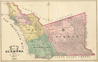
Murray Township was a township located in what is now the Livermore Valley portion of Alameda County, California, including the present day cities of Livermore, Dublin, and Pleasanton, and the census-designated place of Sunol.

Robert Thomas Livermore, also known as Don Roberto Livermore, was an English-born Californian ranchero. He emigrated to Alta California in 1822, eventually becoming a Mexican citizen and a prominent landowner in the Bay Area. The city of Livermore, California is named for him.

Las Positas College (LPC) is a public community college in Livermore, California.
Founded in 1891, Livermore High School is a public high school located in the city of Livermore, California, United States. It is part of the Livermore Valley Joint Unified School District. In 2007, it was chosen as one in four schools in Alameda County to receive the California Distinguished School award.
The Bay Area Conference is a school athletic conference located in the San Francisco Bay Area. The league is a member of the North Coast Section, one of ten sections that comprise the California Interscholastic Federation.

KKDV is an Adult Contemporary radio station located in Walnut Creek, California, broadcasting at 92.1 MHz. With the call letters KKDV, it broadcasts under the slogan "Diablo Valley's Hometown Station." The station serves central Contra Costa County including the Diablo Valley close to Mt. Diablo.
The East Bay Athletic League (EBAL) is a high school sports league in the North Coast Section of the California Interscholastic Federation. The league was created in 1964; previously teams competed in the "East Bay Division" (EBD) of the Diablo Valley Athletic League (DVAL). Its member institutions are located in the eastern region of the San Francisco Bay Area, in the cities of Concord, Danville, San Ramon, Dublin, Pleasanton, and Livermore. In the fall of 2016 the E.B.A.L. expanded to a 10 team league by adding Dublin High School, and Dougherty Valley High School. De La Salle stopped competing in EBAL Football in 2012-13 and now competes as an Independent school in football.
Livermore Valley Joint Unified School District (LVJUSD) is a public school district located in Livermore, California, United States. It is located in Alameda County. Since May 2010, the Superintendent has been Kelly Bowers.
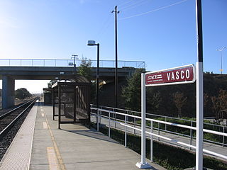
Vasco Road is an ACE station on Vasco Road in eastern Livermore, California.
The Livermore Valley, historically known as the Valle de San José, is a valley in Alameda County, California, located in the East Bay region. The city of Livermore is located in the valley.
Laddville is a former settlement in the western Livermore Valley of Alameda County, California.
Norman Banks "Ike" Livermore, Jr. was an American environmentalist, lumber industry executive, and state official. He was the only member of California governor Ronald Reagan's cabinet to serve during the full eight years of his administration. He played baseball at the 1936 Summer Olympics in Berlin.

Naval Air Station Livermore has nearby airfield landing strips to support the training of US Navy pilots during World War 2. The airfield are called Naval Outlying Landing Field (NOLFs). For the war many new trained pilots were needed. The Naval Outlying Landing Fields provided a place for pilots to practice landing and take off without other air traffic. The remotes sites offered flight training without distractions. Most of the new pilots departed to the Pacific War after training. The Outlying Landing Fields had little or no support facilities. Naval Air Station Livermore opened in 1942 and closed in 1951. The Outlying field closed in 1945, having completed the role of training over 4000 new pilots. To open the needed Outlying Landing Fields quickly, the Navy took over local crop dusting and barnstorming airfields.
