Livingstone Falls

Last updated
Livingstone Falls
Chutes Livingstone.jpg
The beginning of the Livingstone Falls near Kinshasa
Democratic Republic of the Congo relief location map.jpg
Red pog.svg
Congo physical map.svg
Red pog.svg
Africa relief location map.jpg
Red pog.svg
Livingstone Falls
Coordinates 4°19′19″S15°12′28″E / 4.32194°S 15.20778°E / -4.32194; 15.20778
A cataract of Inga Falls Inga03.jpg
A cataract of Inga Falls
Livingstone Falls as seen by Stanley Livingstone Falls.jpg
Livingstone Falls as seen by Stanley
Livingstone falls map Livingstone falls map.jpg
Livingstone falls map

Livingstone Falls (French: Chutes Livingstone; Dutch: Livingstonewatervallen), named for British explorer David Livingstone, are a succession of enormous rapids on the lower course of the Congo River in west equatorial Africa, downstream from Malebo Pool in the Democratic Republic of the Congo. [1]

Contents

Description

Livingstone Falls consist of a series of rapids dropping 900 feet (270 m) in 220 miles (350 km). They start downstream of Malebo Pool and end in Matadi in Bas-Congo. The Congo River has the second largest flow rate in the world after the Amazon, which has no falls or rapids (except near its sources). The lowest rapids of Livingstone Falls, therefore, are the world's largest waterfall in terms of flow rate — provided one accepts these rapids as being a waterfall. An interesting aspect of the 220-mile-long (350 km) Livingstone Falls is the width of the channel. The channel is very narrow: in several stretches the channel width is less than 300 metres and for the majority of the length the channel is less than 800 metres wide. This is an extraordinarily narrow channel since the river flow rate typically exceeds 42,000 cubic metres per second (1,500,000 cu ft/s). Investigations in 2008 and 2009 showed that sections between the rapids may be as deep as 200 m (660 ft). [2] The powerful rapids separate fish populations from one another, causing new species to evolve in close proximity to one another. [2]

History

Although he explored the upper Congo, Livingstone never travelled to this part of the river and the Falls were named in his honour by Henry Morton Stanley. Stanley described the falls as "..the wildest stretch of river that I have ever seen. Take a strip of sea blown over by a hurricane, four miles in length and half a mile in breadth, and a pretty accurate conception of its leaping waves may be obtained. Some of the troughs were 100 yards in length, and from one to the other the mad river plunged. There was first a rush down into the bottom of an immense trough, and then, by its sheer force, the enormous volume would lift itself upward steeply until, gathering itself into a ridge, it suddenly hurled itself 20 or 30 feet straight upward, before rolling down into another trough. If I looked up or down along this angry scene, every interval of 50 or 100 yards of it was marked by wave-towers - their collapse into foam and spray, the mad clash of watery hills, bounding mounds and heaving billows, while the base of either bank, consisting of a long line of piled boulders of massive size, was buried in the tempestuous surf. The roar was tremendous and deafening. I can only compare it to the thunder of an express train through a rock tunnel." [1] :261–262

Since the falls, which start with the Yellala Falls just above Matadi, are a barrier to navigation on the lower part of the river, the Matadi-Kinshasa Railway was constructed to by-pass them.

"Grand Inga" proposed hydroelectric project

Inga Falls on Congo River is a group of rapids in the latter portion of the Livingstone Falls, 177 miles (285 km) after the Malebo Pool. The Congo falls about 96 metres within this set of cataracts. The mean annual flow rate at Inga Falls is about 42,000 cubic metres per second. Given this flow rate and the 96 metre fall, it is possible to calculate that the Inga Falls alone has a power potential of approximately 40 GW.[ citation needed ]

In 2014, Inga Falls was the site of two large hydro-electric power plants and is being considered for a much larger hydro-electric power generating station known as Grand Inga. The Grand Inga project, if completed, would be the largest hydro-electric power generating facility on Earth. The current project scope calls for the use of a flow rate 26,400 cubic metres per second at a net head of 150 metres; this is equivalent to a generating capacity of about 38.9 GW. This hydro-electric generator would be almost double the current world record holder, which is the Three Gorges facility at 22.5GW on the Yangtze River in China.

See also

Related Research Articles

<span class="mw-page-title-main">Congo River</span> River in central Africa

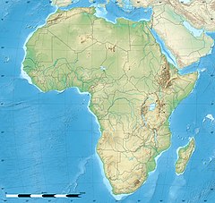
The Congo River, formerly also known as the Zaire River, is the second-longest river in Africa, shorter only than the Nile, as well as the third-largest river in the world by discharge volume, following the Amazon and Ganges rivers. It is the world's deepest recorded river, with measured depths of around 220 m (720 ft). The Congo–Lualaba–Luvua–Luapula–Chambeshi River system has an overall length of 4,700 km (2,900 mi), which makes it the world's ninth-longest river. The Chambeshi is a tributary of the Lualaba River, and Lualaba is the name of the Congo River upstream of Boyoma Falls, extending for 1,800 km (1,100 mi).

<span class="mw-page-title-main">Waterfall</span> A point in a river or stream where water flows over a vertical drop

A waterfall is any point in a river or stream where water flows over a vertical drop or a series of steep drops. Waterfalls also occur where meltwater drops over the edge of a tabular iceberg or ice shelf.

<span class="mw-page-title-main">Itaipu Dam</span> Dam along the Brazil–Paraguay border

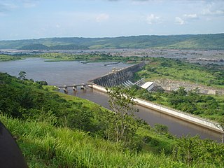
The Itaipu Dam is a hydroelectric dam on the Paraná River located on the border between Brazil and Paraguay. It is the third largest hydroelectric dam in the world, and holds the 45th largest reservoir in the world.

<span class="mw-page-title-main">Victoria Falls</span> Waterfall on the Zambezi River in Zambia and Zimbabwe

Victoria Falls is a waterfall on the Zambezi River in southern Africa, which provides habitat for several unique species of plants and animals. It is located on the border between Zambia and Zimbabwe and is one of the world's largest waterfalls, with a width of 1,708 m (5,604 ft).

<span class="mw-page-title-main">Lualaba River</span> River in Democratic Republic of the Congo

The Lualaba River flows entirely within the eastern part of Democratic Republic of the Congo. It provides the greatest streamflow to the Congo River, while the source of the Congo is recognized as the Chambeshi. The Lualaba is 1,800 kilometres (1,100 mi) long. Its headwaters are in the country's far southeastern corner near Musofi and Lubumbashi in Katanga Province, next to the Zambian Copperbelt.

<span class="mw-page-title-main">Pool Malebo</span> Widening of the Congo River; part of the border between the R Congo and the DR Congo

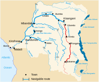
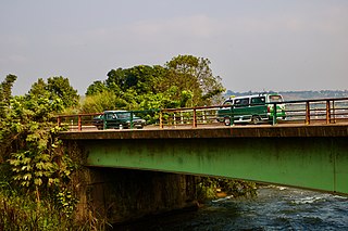
The Pool Malebo, formerly Stanley Pool, also known as Mpumbu, Lake Nkunda or Lake Nkuna by local indigenous people in pre-colonial times, is a lake-like widening in the lower reaches of the Congo River. The river serves as the border between the Republic of the Congo to the north and the Democratic Republic of the Congo to the south.

Colonization of the Congo Basin refers to the European colonization of the Congo Basin of tropical Africa. It was the last part of the continent to be colonized. By the end of the 19th century, the Basin had been carved up by European colonial powers, into the Congo Free State, the French Congo and the Portuguese Congo.

<span class="mw-page-title-main">Inga Falls</span> Cataract on the Congo River in the Democratic Republic of the Congo

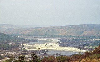
Inga Falls is a rapid 40 km from Matadi in the Democratic Republic of the Congo where the Congo River drops 96 m (315 ft) over the course of 15 km (9 mi). The falls are part of a larger group of rapids in the lower Congo River. Livingstone Falls are located upstream closer to the Pool Malebo. These falls have formed in a sharp bend of Congo River where the width of river fluctuates from more than 4 km to only 260 m.

<span class="mw-page-title-main">Shivanasamudra Falls</span> Waterfall in Karnataka, India

Shivanasamudra Falls is a cluster of waterfalls on the borders of Malavalli, Mandya and Kollegala, Chamarajanagara, in Karnataka, India, situated along the river Kaveri. The falls form the contour between the districts of Chamarajanagara and Mandya. The Bharachukki Falls in Kollegala, with a height of 69 metres, and the Gaganachukki Falls in Malavalli, with a height of 90 metres, collectively form the Shivanasamudra Falls.

<span class="mw-page-title-main">Inga dams</span> Two hydroelectric dams on the Congo River in western DR Congo

The Inga Dams are two hydroelectric dams connected to one of the largest waterfalls in the world, Inga Falls. They are located in the western Democratic Republic of the Congo and 140 miles southwest of Kinshasa.

<span class="mw-page-title-main">Robert-Bourassa generating station</span> Hydroelectric power station in Québec, Canada

The Robert-Bourassa generating station, formerly known as La Grande-2 (LG-2), is a hydroelectric power station on the La Grande River that is part of Hydro-Québec's James Bay Project in Canada. The station can generate 5,616 MW and its 16 units were gradually commissioned between 1979 and 1981. Annual generation is in the vicinity of 26500 GWh.

Kinshasa is the capital and largest city of the Democratic Republic of the Congo. It is situated on the Congo River near Pool Malebo and forms a single urban area with Brazzaville which is the capital of the neighbouring Republic of the Congo. Considered a megacity, it is among the largest urban communities in Africa.

<span class="mw-page-title-main">Energy in the Democratic Republic of the Congo</span>

The Democratic Republic of the Congo was a net energy exporter in 2008. Most energy was consumed domestically in 2008. According to the IEA statistics the energy export was in 2008 small and less than from the Republic of Congo. 2010 population figures were 3.8 million for the RC compared to CDR 67.8 Million.

<span class="mw-page-title-main">Omanawa River</span> River in New Zealand

The Omanawa River is a river of the Bay of Plenty Region of New Zealand's North Island.

<span class="mw-page-title-main">Grand Inga Dam</span> Proposed hydro power generation complex in the Democratic Republic of the Congo

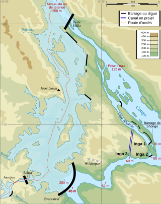
The Grand Inga Dam is a series of seven proposed hydroelectric power stations at the site of the Inga Falls, in the Democratic Republic of the Congo. If built as planned, the 40-70 GW project would be the largest power station in the world.

The Livingstone Inland Mission (LIM) was an evangelical missionary society that operated in what is now the Democratic Republic of the Congo between 1878 and 1884.

<span class="mw-page-title-main">Yellala Falls</span> Waterfall in the Congo river, DRC

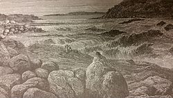
The Yellala Falls are a series of waterfalls and rapids on the Congo River just upstream from Matadi in the Democratic Republic of the Congo. The falls are the lowest of a long series of rapids that render the river unnavigable, forcing colonial explorers to travel by foot as far as the Stanley Pool 350 kilometres (220 mi) upstream. The Congo is the second largest river in the world by volume of water discharged, and the deepest in the world. The section of river that ends with the Yellala falls has over 300 species of fish, many found nowhere else.

<span class="mw-page-title-main">Isangila</span> Place in Kongo Central, DR Congo

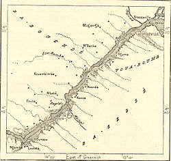
Isangila, formerly called Isanghila or Isanguila is the headquarters of a sector of the Seke-Banza territory in Kongo Central province of the Democratic Republic of the Congo.

<span class="mw-page-title-main">Manyanga</span> Place in Kongo Central, Democratic Republic of the Congo

Manyanga was a staging post on the route from the coast to Léopoldville during the days of the Congo Free State. It was at the upper end of a navigable reach of the Congo River from Isangila, further downstream to the west. Above Manyanga goods had to be carried by land round the falls and rapids to Stanley Pool.

<span class="mw-page-title-main">Djoué River</span> River in Republic of the Congo

The Djoué River is a river of the Republic of the Congo. It is a right tributary of the Congo River.

References

  1. 1 2 Stanley, H.M., 1899, Through the Dark Continent, London: G. Newnes, Vol. One ISBN   0486256677, Vol. Two ISBN   0486256685
  2. 1 2 Weisberger, Mindy (12 January 2020). "Dying Fish Revealed Congo Is World's Deepest River". livescience.com. LiveScience. Retrieved 14 January 2020.