
Cadair Berwyn, Cader Berwyn or Craig Uchaf is a mountain summit in north-east Wales with a height of 832 metres (2,730 ft) above sea level. It is the highest point in the Berwyn range, the highest in North East Wales and the highest significant summit in Wales outside the National Parks. Cadair Berwyn and Foel Cedig to the west are the two Marilyns that form the Berwyn range. The undulating plateau of the range also includes a large number of other summits above 2,000 feet (610 m), including satellite summits of Cadair Berwyn and many which are classed as Nuttalls.

The River Dwyryd, is a river in Gwynedd, Wales which flows principally westwards; draining to the sea into Tremadog Bay, south of Porthmadog.
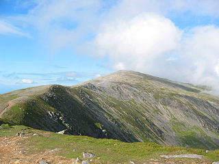
Carnedd Dafydd is a mountain peak in the Carneddau range in Snowdonia, Wales, and is the third highest peak in Wales, or the fourth if Crib y Ddysgl on the Snowdon ridge is counted. Situated south-west of Carnedd Llewelyn and north of Pen yr Ole Wen, Carnedd Dafydd is on the main ridge of the Carneddau, and on the border between Gwynedd and Conwy. The average annual temperature of the mountain is around 3–4 °C.

The Nantlle Valley is an area in Gwynedd, North Wales, characterised by its numerous small settlements.

Foel-fras (944 m) is a mountain in the Carneddau range, about 10 km east of Bethesda in North Wales. It lies on the border between the counties of Gwynedd and Conwy. With a summit elevation of 944 m it is officially the eleventh-highest summit in Wales. Foel-fras is located at the northern end of the main ridge of the Carneddau, between Drum to the north and Foel Grach to the south, with the subsidiary summit of Garnedd Uchaf (925 m) between it and Foel Grach. Due south and 400 m below lies the reservoir of Llyn Dulyn, while the smaller reservoir of Llyn Anafon lies to the north.

The Afon Llyfni is a small river in North Wales which arises as Nant Drws y Coed between Mynydd Mawr and Mynydd Drws-y-Coed just to the west of Snowdon.

Y Fron, also known locally as Cesarea, after the chapel, is a country village on the south-west side of Moel Tryfan, overlooking the Nantlle Valley, in North Wales, near Rhosgadfan and Carmel, on the tail of Mynydd Mawr, with epic views of Trum Y Ddysgl and Craig Cwm Silyn. It is in the community of Llandwrog.

Llyn Dulyn is a lake on the edge of the Carneddau range of mountains in Snowdonia, North Wales. The lake is 33 acres (130,000 m2) in extent and 189 feet deep. Less than a kilometre to its south lies the smaller Llyn Melynllyn. Cliffs rise steeply from the lake edge up to the summits of Garnedd Uchaf and Foel Grach, giving it a dark brooding appearance - hence its name.

Mynydd Graig Goch is the western end peak of the Nantlle Ridge, and is a subsidiary summit of Craig Cwm Silyn. It is also the most westerly 2000 ft peak in Wales. For many years it was excluded from lists of the Welsh 2000 ft mountains due to a spot height of 609 metres (1998') on OS maps. However, this changed in 2008; after years of speculation a group of hillwalkers carried out a precise GPS survey of the peak, measuring the absolute height as 609.75 metres.
Nantlle is a small village in the slate quarrying Nantlle Valley in Gwynedd, Wales. It lies on the north shore of Llyn Nantlle Uchaf and is part of the community of Llanllyfni. The population was 228 in 2011 with 42% born in England.
Llandecwyn is a hamlet near Penrhyndeudraeth in Gwynedd, Wales.

Upper Talley Lake and Lower Talley Lake are two small lakes immediately north of the village of Talley, 7 miles (11 km) north of Llandeilo in Carmarthenshire, Wales. They are protected as a Site of Special Scientific Interest (SSSI).

Cilgwyn quarry is a slate quarry located on the north edge of the Nantlle Vale, in North Wales. It is one of the earliest slate quarries in Great Britain, being worked as early as the 12th century. King Edward I of England was reputed to have stayed in a house roofed by Cilgwyn slates, during the Welsh wars of independence. It is one of the major slate quarries in the Nantlle Valley area.

Pen Ty-Nant is a hill within the Snowdonia National Park in Gwynedd, North Wales.
The Upper Corris Tramway was a 2 ft 3 in gauge horse-worked tramway that connected the slate quarries around the villages of Corris and Corris Uchaf with the Corris Railway at Maespoeth Junction. It was just over 1.8 miles (2.9 km) long.

