LoDo, Denver

Last updated
Union Station in LoDo Denver Union Station; Front end - October 11, 2004.jpg
Union Station in LoDo

LoDo (Lower Downtown) is an unofficial neighborhood in Denver, Colorado, and is one of the oldest places of settlement in the city. It is a mixed-use historic district, known for its nightlife, and serves as an example of success in urban reinvestment and revitalization. The current population is approximately 21,145.

Contents

History

Prior to European exploration of the area, Native Americans, particularly the Arapaho tribe, established encampments along the South Platte River near or in what is now LoDo. In 1858, after the discovery of gold in the river, General William Larimer founded Denver by putting down cottonwood logs in the center of a square mile plot that would eventually be the current LoDo neighborhood, making LoDo both the original city of Denver, as well as its oldest neighborhood. Then, like now, LoDo was a bustling and sometimes wild area known for its saloons and brothels. During the Sand Creek Massacre, it was LoDo where the heads of the slaughtered Arapaho tribe were paraded in victory.

As Denver grew, city leaders realized a railroad was needed to keep Denver a strong city, especially when the transcontinental railroad bypassed Denver for Cheyenne, Wyoming. In 1870, after much cajoling from town leaders, residents passed bonds that brought a 106-mile (171 km) rail spur from Cheyenne. This and later train lines ended up in the Central Platte Valley, adjacent to LoDo. Union Station became the place most people traveled into the city and LoDo would be the first part of the city they would see. This section eventually became Denver's Chinatown from the 1870s to the 1880s, only to be torn down by race riots.

By the mid-twentieth century, what was once a thriving business area had become a skid row. As highways and airports diminished the dominance of passenger railroad transportation, the importance of Union Station, LoDo's most prominent building, waned.

Wazee St in LoDo LodoWazee.jpg
Wazee St in LoDo

The Lower Downtown Historic District, known as LoDo, was created by the enactment of a zoning ordinance by Denver City Council in March 1988. The resolution's intent was to encourage historic preservation and to promote economic and social vitality in Denver's founding neighborhood at a time when it still held significant historic and architectural value. [1] The status granted by this special designation provided protection to the community's archivable resources and to the 127 contributing historic structures that remained after roughly 20% of Lower Downtown's buildings had been demolished through DURA policies in the 1960s and 1970s. LoDo's historic district ordinance includes zoning that restricts building height and encourages mixed-use development. It stipulates strict design guidelines for rehabilitation and new construction. [2] These guidelines have been challenged by out-of-state developers but are vigorously defended by residents.

During this time, the neighborhood began its renaissance and new businesses opened. Gradually LoDo became a destination neighborhood. By the time Coors Field opened on the edge of the LoDo Historic District in 1995, the area had revitalized itself, becoming a new, hip neighborhood filled with clubs, restaurants, art galleries, boutiques, bars, and other businesses. Pepsi Center, located on the other edge of the neighborhood, opened in 1999 and further established the neighborhood as a sport fan's paradise. New residential development came to LoDo, transforming old warehouses into pricey new lofts. [3]

Geography

The LoDo neighborhood, near Denver's Union Station, highlighted on this map of Denver neighborhoods. LoDohighlight.png
The LoDo neighborhood, near Denver's Union Station, highlighted on this map of Denver neighborhoods.

The B-7 zoned historic district is roughly bordered by:

When referring to the greater LoDo area, people often include adjacent neighborhoods that are not a part of the official historic district, but encompass LoDo's sphere of influence. This unofficial greater area includes Larimer Square, the Auraria Campus, Riverfront Park, the Central Platte Valley, Union Station North, River North, and the Ballpark neighborhoods.

LoDo is located in north-central Denver, directly northwest of the downtown CBD, near the confluence of Cherry Creek and the South Platte River.

Economy

The Wynkoop Brewing Company, located on 18th Street in LoDo Wynkoop.JPG
The Wynkoop Brewing Company, located on 18th Street in LoDo

Land in the Lower Downtown Historic District is zoned B-7, which includes building height limitations and encourages mixed-use development and provides strict design guidelines for rehabilitation and new construction. Projects must go through an architectural design review, which allows LoDo to retain its pedestrian scale and historic character as it continues to densify.

The average cost of a home in LoDo in May of 2016 was $701,286.

Oxford Hotel

The Oxford Hotel, built in 1891, is listed on the National Register of Historic Places. The Cruise Room is a hotel bar with historic art deco interior, that was operated as an illicit speakeasy.

Wynkoop Brewing Company

The Wynkoop Brewing Company, a brewpub founded in 1988 by Colorado's 42nd Governor John Hickenlooper with partners Russell Schehrer, Mark Schiffler, and Jerry Williams, [5] sponsors the "Beerdrinker of the Year" competition, which is hosted yearly in one of the banquet halls. [6] The Wynkoop has a large billiards hall on its top floor. [7]

Arts and culture

In the summer of 2006, LoDo hosted the cast members of MTV's popular reality show The Real World , as season 18: The Real World: Denver . Several movies have also been filmed, wholly or in part, in the neighborhood, including the Eddie Murphy film Imagine That (2009). LoDo's combination of contemporary architecture sprinkled among historic buildings, beautiful mountain views, access to Cherry Creek and nearby parks, plus its proximity to two major sporting venues, make it an attractive location for television and movie filming.

The 70+ bars and restaurants in the historic district provide a positive economic impact for the city. However, late night violence, including a fatal shooting, has caused concern. [8] [9] The police are increasing foot patrols and asking private security officers to assist with the 2:00 am "let out" period. A security task force, made up of members of the public, Denver Police, neighborhood and business associations, and bar and club owners has convened to examine the issue.

Community

The LoDo District, Inc., a non-profit neighborhood and business association, represents both the residential and commercial communities, and functions as a LoDo-specific chamber of commerce, visitors bureau, registered neighborhood organization, advocacy agent, and marketing entity. The Lower Downtown Neighborhood Association, the residential association, is a non-profit organization committed to seeking quality living conditions amid the mixed uses of the Lower Downtown area.

Because of the numerous bars and clubs in the area, LoDo is also a popular location for the nightlife of Denver.

Attractions

View of LoDo and Mount Evans. IMG00171 Stitch.jpg
View of LoDo and Mount Evans.

Related Research Articles

<span class="mw-page-title-main">Denver</span> Capital of Colorado, United States

Denver is a consolidated city and county, the capital, and most populous city of the U.S. state of Colorado. Its population was 715,522 at the 2020 census, a 19.22% increase since 2010. It is the 19th-most populous city in the United States and the fifth most populous state capital. It is the principal city of the Denver–Aurora–Lakewood metropolitan statistical area, the most populous metropolitan statistical area in Colorado and the first city of the Front Range Urban Corridor.

<span class="mw-page-title-main">Colorado Territory</span> Historic region of the US, 1861 to 1876

The Territory of Colorado was an organized incorporated territory of the United States that existed from February 28, 1861, until August 1, 1876, when it was admitted to the Union as the State of Colorado.

<span class="mw-page-title-main">Confluence Park</span> Park in Denver, Colorado, United States

Confluence Park is an urban park encompassing the confluence of Cherry Creek and the South Platte River in Denver's Lower Downtown (LoDo), a bustling district of 19th-century brick warehouses and storefronts that has been redeveloped since the late 1980s.

<span class="mw-page-title-main">Tattered Cover</span> Independent bookstore chain in Colorado, United States

Tattered Cover is a bookstore chain in Denver, Colorado. It is one of the largest independent bookstores in the United States. Tattered Cover is open seven days a week at all branches, hosts prominent book signings, and is known for its customer service. Together, the stores maintain an inventory of over half a million books. Its LoDo store houses an events space that can seat over 250 persons, while its East Colfax store can seat around 100.

<span class="mw-page-title-main">Auraria, Denver</span> Early neighborhood in Denver, Colorado

Auraria was a small mining settlement in the Kansas Territory in the United States. Today it survives in its original location as a neighborhood of Denver, Colorado, south of the confluence of Cherry Creek and the South Platte River.

<span class="mw-page-title-main">William Larimer Jr.</span> American politician

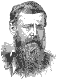
William Larimer Jr. was an American businessman, investor, militia general, and politician who is best known as the founder of Denver, Colorado, in 1858. Larimer often went by "General Larimer", having acquired the title in the Pennsylvania Militia.

<span class="mw-page-title-main">Denver Union Station</span> Train station in Denver, Colorado

Denver Union Station is the main railway station and central transportation hub in Denver, Colorado. It is located at 17th and Wynkoop Streets in the present-day LoDo district and includes the historic station house, a modern open-air train shed, a 22-gate underground bus station, and light rail station. A station was first opened on the site on June 1, 1881, but burned down in 1894. The current structure was erected in two stages, with an enlarged central portion completed in 1914.

<span class="mw-page-title-main">Cherry Creek, Denver</span> Neighborhood in Denver, Colorado

Cherry Creek is a neighborhood in Denver, Colorado, in the United States. It has many newer residences mixed in with some of Denver's older homes.

<span class="mw-page-title-main">Neighborhoods of Tulsa, Oklahoma</span>

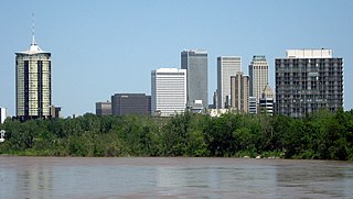
Tulsa is the second-largest city in the state of Oklahoma. It has many diverse neighborhoods due to its size.

The History of Denver details the history of the City and County of Denver, Colorado, the United States from its founding in 1858 to modern-day. Ever since the gold rush, Denver has been Colorado’s gateway and major metropolis. With its location at the intersection of the plains and the mountains, its people and institutions have tied together the sections of the state and served as a point of contact between Colorado and the wider world. As the state’s political capital and largest city, Denver has been the natural center for decision-making. New programs and ideas have typically spread outward through the public agencies and private organizations that have Denver headquarters.

<span class="mw-page-title-main">Highland, Denver</span>

Highland is a distinct city-center neighborhood in Denver, Colorado, United States, bounded by West 38th Avenue to the north, a Union Pacific Railroad line on the east, the South Platte River to the southeast, Speer Boulevard on the south, and Federal Boulevard on the west. The Highlands is sometimes used to refer to two separate city-center neighborhoods in Denver; Highland and West Highland, although the two neighborhoods are distinct. Highland and West Highland are both in the area that is referred to as the Northside. Highland is located immediately northwest of downtown. Note that the Highland neighborhood association has a slightly different definition with the easternmost boundary stopping at I-25. And the West Highland neighborhood to the immediate west of Highland, with the borders of 38th and 29th Avenues on the north and south and Federal and Sheridan Boulevards on the east and west. To distinguish between its immediately adjacent neighbor, West Highland, Highland is sometimes referred to as East Highland, Lower Highland or LoHi. The two together are casually called "the Highlands," a term which often falsely encompasses other Northwest Denver neighborhoods such as Jefferson Park, Sunnyside and Berkeley. Realtors have particularly pushed the inclusion of the recently gentrified Berkeley, located directly north of West Highland, as part of the Highlands, sometimes going so far as to refer to Berkeley and parts of Sunnyside as the "Upper Highlands". To add further confusion, within the Highlands neighborhoods there are several historic designations of various degrees, including Potter Highlands, Scottish Highlands and Highlands Park.

<span class="mw-page-title-main">Baker, Denver</span> Neighborhood in Denver, Colorado, United States

Baker is a neighborhood in Denver, Colorado, United States.

<span class="mw-page-title-main">Street system of Denver</span>

The oldest part of Denver, Colorado, now the neighborhoods of Auraria Campus, LoDo, much of downtown, and Five Points, is laid out on a grid plan that is oriented diagonal to the four cardinal directions. The rest of the city, including the eastern part of downtown, is laid out primarily on a grid oriented to the cardinal directions. In this larger grid, from east to west, there are generally 16 city blocks per mile, except between Zuni Street and Lowell Boulevard in west Denver. From north to south, there are typically eight blocks per mile, although there are many areas with more blocks per mile. Addresses follow a decimal system, with addresses advancing by one hundred at each cross street.

<span class="mw-page-title-main">Downtown Denver</span> Human settlement in Denver, Colorado, United States

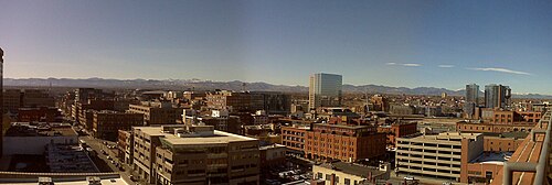
Downtown Denver is the main financial, commercial, business, and entertainment district in Denver, Colorado, United States. There is over 23 million square feet (2,100,000 m2) of office space in downtown Denver, with 132,000 workers. The downtown area consists mostly of the neighborhoods of Union Station and Central Business District. LoDo and RiNo are notable districts within downtown. Some of the more popular specific attractions include the 16th Street pedestrian mall, Larimer Square, the re-emerging Theatre District near Curtis and 14th, and Civic Center Park. Surrounding neighborhoods include Capitol Hill and Uptown to the east, Highland to the west, Five Points to the north, and the Golden Triangle to the south.

<span class="mw-page-title-main">Lincoln Park, Denver</span> Neighborhood in Denver, Colorado, United States of America

Lincoln Park is a neighborhood and public park close to downtown Denver, Colorado and the location of the Art District on Santa Fe. The neighborhood is one of Denver's oldest and is just to the south of the area where Denver was first settled in the 1850s. Many houses date from about 1900. The neighborhood is sometimes called "La Alma/Lincoln Park" or the West Side.

<span class="mw-page-title-main">Union Station, Denver</span> Neighborhood in Denver, Colorado

Union Station is a downtown neighborhood of Denver, Colorado. In 2020, the population of the neighborhood was roughly 5,878.

Dana Hudkins Crawford is an American architectural conservation developer and preservationist working in Denver, Colorado. She has been involved in almost every renovation project in downtown Denver, from the initial designation of the LoDo District and creation of Larimer Square to the Union Station. She was recognized by her alma mater, Radcliffe College, for the Larimer Square project, was inducted into the Colorado Women's Hall of Fame, and in 2013 the hotel at the restoration project of Union Station was renamed as the Crawford Hotel in honor of her contributions to preserve the history of Denver.

<span class="mw-page-title-main">Union Station North</span> Neighborhoods in Denver in Colorado, United States

Union Station North, formerly known as Prospect, is a neighborhood within the city limits of Denver, Colorado. Previously dominated by industrial buildings, waste, railroad tracks and considered an area of the city to be avoided, today it has been rehabilitated into multi-story residential buildings, restaurants, amenities, easy access to downtown Denver, and is a short walk to the South Platte River Trail, which runs along its northern boundary.

References

  1. LoDo District, Inc. a membership organization in Lower Downtown Denver with historical, cultural, retail & entertainment - LoDo District
  2. Denver Office of the Clerk and Recorder | DenverGov.org
  3. Archived 2005-09-06 at the Wayback Machine . City of Denver. Retrieved on December 10, 2007
  4. Denver Union Station
  5. "Parker: Wynkoop lets ale out of bottle - The Denver Post". www.denverpost.com. 2009-08-23. Retrieved 2009-08-25.
  6. "Beer News - Wynkoop Announces 2009 Beerdrinker of the Year Finalists". thefullpint.com. 5 February 2009. Retrieved 2009-08-25.
  7. "Wynkoop Brewing Company - Our Story". www.wynkoop.com. 10 August 2015. Retrieved 2020-10-11.
  8. "Other nightclub shootings in Denver". Denver Post. 2007-11-05.
  9. Family Mourns Man Killed In Nightclub Shooting – Denver News Story – KMGH Denver

39°45′13″N105°00′01″W / 39.75359°N 105.00035°W / 39.75359; -105.00035