Loch Hope

Last updated

Loch Hope
Loch Hope (northern end) - geograph.org.uk - 94513.jpg
Sutherland UK relief location map.jpg
Red pog.svg
Loch Hope
LocationScotland
Coordinates 58°27′06″N4°38′15″W / 58.45169830°N 4.63755031°W / 58.45169830; -4.63755031
Primary inflows Strathmore River
Primary outflows River Hope
Basin  countriesUnited Kingdom
Surface area7 Km squared (2.7 square miles)
Surface elevation3.4 metres (11 ft)
FrozenOccasionally parts will freeze
SettlementsHope, Lochside, Muiseal

Loch Hope is a loch in the Durness parish in Sutherland in the Highland Council Area of northern Scotland. It is located on the A838 main road. The settlements of Hope, Lochside, and Muiseal directly on the loch in addition nearby there's Inverhope, Heilam, Moine House, Alltnacaillich, Strathmore, etc.. The Loch is a large tourist destination for the area around it. [1] [2] [3]

Contents

Geography

Rivers

Flowing out of Loch Hope there's the 1.25 mile (2 km) river hope which flows to Loch Eriboll. [4] Flowing in there's the Strathmore river, which brings water all the way in from Loch Staonsaid and nearly as far as Loch Meadie. A sea of tributaries and temporary brooks and streams bring in the water from the hugely mountainous area and the entire river disperses very quickly. Many other tributaries flow directly into the very long loch some of which split up further. [1]

Mountains

For starters there's Ben Hope over 900 metres tall and with 700 metres of prominence however the entire area is full of many different mountains many of which bring water into the loch, even as far as Creag Staonsaid for example. [1] [5]

Settlements

Many settlements are directly on Loch Hope and many others in the catchment area.

Hope

Hope is by far the most notable of the settlements on the loch and is in itself named after it. It is at the tip of the Loch right where the River Hope starts flowing. The Hope Bridge just north of it is already on the river. There are seven archaeological sites within the settlement and an additional two hut circles just north of the village. [6] The riverside around it is full of weirs, and the settlement boasts a very small permanent population but is one of very few on the loch to have any and is the largest in the area. It has one lodge but it is old and is currently undergoing overhaul with plans for it to become a shooting lodge. [7] There's a small enclosure in the settlement and many paths on the other side of the river bank to Hope, finally there's the ferryman's house on the riverside. [8]

Lochside

Like most places in Scotland unimaginatively called Lochside, Lochside is on the lochside of Loch hope. It is located just east of the loch on the small stream that is Allt na Raipe and within Lochside there's a sheepfold. There are 2 archaeological sites in Lochside. Aside from the road around the Loch, there's only a couple small trails by the settlement. [8] There are some cottages within Lochside. [2]

Braesgill

A smaller settlement halfway down the loch, Braesgill is yet another farmstead located along the lochside of loch hope. It is named after the river it sits on that flows into Loch Hope it is home to 3 archaeological sites including a simple hut circle. [8] [9] Braesgill has been listed by Ordnance Survey since 1871 in Sutherland Volume 12 although it now ceases to appear on their maps. [10] [11]

Merkan

Merkan is a mostly lost settlement just south of Braesgill, it too is named after the river it sits on but also a nearby small peak with the same name. It has been depicted by Ordnance Survey maps since 1878. [12] It's located just west of the lochside road and a very small carved path links the remains of a building to it. [13] It has an alternate name, Meirgeach.

Muiseal

Muiseal is another small farmstead, just south of the Loch. It has listings on Openstreetmap and OS and is labelled as a hamlet. [14] [2] It's far more well known than most of the other settlements. Muiseal is surprisingly home to no archaeological sites however two are just south of it. Muiseal is a reference point for many trails and mountains in the area and the brook Allt An Muiseal runs through it giving it its name. [15] [16] It is 11 metres above sea level, there is a parking lot within it to provide for some of the trails in the area, 1 of which goes to Ben Hope. There's another small track which leads to the Strathmore river and on the other side of the river there's a labelled place called Luib Bhan. Finally there's 2 roofed buildings within Muiseal. [6]

Arnaboll

Arnaboll is a now abandoned farmstead on the other side of Loch Hope, named after a river and hill with the same name. It consists of an intact building and a prehistoric Hut circle. [6] [17] To add to this there's one archaeological site within Arnaboll. [18]

Alltnacaillich

Alltnacaillich is one of few places near the loch to get a google maps listing. [19] It is a permanently inhabited hamlet on the Strathmore River Just south of Muiseal. [6] There are 7 archaeological sites within Alltnacaillich. [20] There is a sort of central area of the settlement with housing and trails leaving out of it, all this is atop Allt na Caillich a river where the river is named off of unoriginally. Some of these trails lead to peaks and mountains, but most go west towards the Strathmore where there are links to prehistoric sites, a homestead, graveyard and a nature reserve. Alltnacaillich is also home to a bridge over the Strathmore and a burnt mound and nearby there's Don Dornaigil. [2] [5] [6] Despite there being residents there is no form of hotel or lodge in Alltnacaillich. [21] The hamlet has etymology as it means the burn of the ould woman which was actually the naming of the aforementioned river. [22]

Moine House

Moine house or Moin House is located east of the loch. It has 3 archaeological sites in the area and is near the banks of another loch, Loch Nam Meur Liath which in itself is near to a larger loch, Loch Maovalley which flows into Loch Hope. It consists of one derelict building and a couple trails. It was built as a place of refuge for people travelling on the nearly built road across the area, now the A838 and has lost its roof. [23] The house was also permanently inhabited and due to its importance in helping travelers, it became a marked point on many different maps. [24] [25] Moine means Gaelic for Moss and the house was inhabited by many notable families some of which would have as many as 8 people. [26] The now archaeological site now has a car park for visitors. [24]

Tourism

On top of there being plans for the abandoned lodge in Hope to be restored into a shooting lodge, there is already a lot of toursim in the area.

Related Research Articles

<span class="mw-page-title-main">Durness</span> Human settlement in Scotland

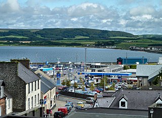
Durness is a village and civil parish in the north-west Highlands of Scotland. It lies on the north coast of the country in the traditional county of Sutherland, around 120 miles north of Inverness. The area is remote, and the parish is huge and sparsely populated, covering an area from east of Loch Eriboll to Cape Wrath, the most north-westerly point of the Scottish mainland.

<span class="mw-page-title-main">Loch Tay</span> Freshwater loch in the central highlands of Scotland

Loch Tay is a freshwater loch in the central highlands of Scotland, in the Perth and Kinross and Stirling council areas. It is the largest body of fresh water in Perth and Kinross, and the sixth largest loch in Scotland. The watershed of Loch Tay traditionally formed the historic province of Breadalbane.

<span class="mw-page-title-main">Drumnadrochit</span> Human settlement in Scotland

Drumnadrochit is a village in the Highland local government council area of Scotland, lying near the west shore of Loch Ness at the foot of Glen Urquhart. The village is close to several neighbouring settlements: the villages of Milton to the west, Kilmore to the east and Lewiston to the south. The villages act as a centre for regional tourism beside Loch Ness, as well as being a local economic hub for the nearby communities.

<span class="mw-page-title-main">Achanalt</span> Human settlement in Scotland

Achanalt is a railway halt in Strath Bran, Ross and Cromarty, in the Scottish council area of Highland. It is served by a railway station on the Kyle of Lochalsh Line from Inverness to Kyle of Lochalsh.

<span class="mw-page-title-main">River Shin</span> River in northern Scotland

The River Shin is a river in the Scottish North West Highlands.

Sorbie is a small village in Wigtownshire, Machars, within the Administration area of Dumfries and Galloway Council, Scotland.

<span class="mw-page-title-main">Fiskavaig</span> Human settlement in Scotland

Fiskavaig or Fiscavaig is a picturesque crofting settlement on the north-west shore of the Minginish peninsula, Isle of Skye in the Highland Council area.

<span class="mw-page-title-main">Rubha an Dùnain</span> Peninsula in Scotland

Rubha an Dùnain or Rubh' an Dùnain is an uninhabited peninsula to the south of the Cuillin hills on the Isle of Skye in Scotland. It contains unique archaeological sites which in 2017 were designated as a historic monument of national importance by Historic Environment Scotland.

<span class="mw-page-title-main">Inch, Dumfries and Galloway</span> Human settlement in Scotland

Inch is a civil parish in Dumfries and Galloway, southwest Scotland. It lies on the shore of Loch Ryan, in the traditional county of Wigtownshire.

Old Luce is a civil parish in Dumfries and Galloway, Scotland. It lies in the Machars peninsula, in the traditional county of Wigtownshire. The parish is around 10 miles (16 km) long and 8 miles (13 km) broad, and contains 40,350 acres (16,330 ha).

Ardvar is a small settlement in Assynt district of Sutherland located within the Highland council area of Scotland. It is located on the banks of Loch Ardbhair. It is located 3 miles from Drumbeg and 5 from Unapool. It is also 25 miles from Ullapool and the A835 road. 1 mile from the town is the B869 road. Ardvar is elevated at around 20 metres above sea level.

<span class="mw-page-title-main">Unapool</span> Settlement in Sutherland, Scotland

Unapool is a small settlement in the Assynt district of Sutherland in the Highland council area of Scotland. It is located on the A894 between Durness and Ullapool. Ullapool and the A835 are located nearly 30 miles away. The nearest settlements to Unapool are Kylesku and Newton. Loch Unapool is nearby and the village is sandwiched between Loch a Chairn Bhain, Loch Gleann Dubh and Loch Glencoul.

Loch Dionard is a medium-sized loch in the Durness Parish, in Sutherland, Highland Council Area, Northern Scotland. It is in the North-Western Highlands about four miles south of Polla.

<span class="mw-page-title-main">Loch Merkland</span> Inland loch in Sutherland, Northern Scotland

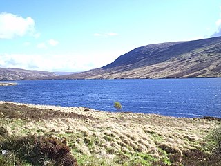
Loch Merkland is a large long inland loch in Sutherland, Northern Scotland. It is located adjacent to the A838 main road which provides almost all access to the Loch and the Merkland Lodge to the south of it. There are many trails and hiking paths in the area, as per usual in the highlands of Scotland. On the Banks just above the Lodge there's also Merkland Cottage meaning there are residents around the Loch.

<span class="mw-page-title-main">Loch Borralan</span> Loch in Ross and Cromarty, Scotland

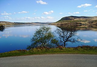
Loch Borralan is a freshwater loch in the Assynt District of Sutherland in the Highland Council Area, northern Scotland.

<span class="mw-page-title-main">Loch Badanloch</span> Lake in northern Scotland

Loch Badanloch is a loch in Sutherland in the Highland Council Area of northern Scotland.

Loch Nan Clar is a loch in Sutherland in the Highland Council Area of northern Scotland. It is located near the B871 main road, and there is no settlement directly on the lake although the hamlets of Gearnsary and Garvault are very nearby. The loch is used as both a reservoir and as one of few salmon fishery areas in Highland.

Loch Rimsdale is a loch in the Farr parish in Sutherland in the Highland Council Area of northern Scotland. It is located near the B871 main road. There are no settlements directly on the loch however the hamlet of Gearnsary and the Farmstead of Rimsdale are very nearby. The loch is used as both a reservoir and as one of few salmon fishery areas in Highland.

<span class="mw-page-title-main">Loch Naver</span> Loch in Scotland

Loch Naver is a loch in the Farr parish in Sutherland in the Highland council area of northern Scotland. It is situated upon the B873 main road. Upon the loch are also the settlements of Kilbreck, Redhackaistelll and Dailmallhart. Additionally Alltnaharra and Achanaes are nearby. Fishing is very popular on Loch Naver and the River Naver.

<span class="mw-page-title-main">Loch Choire</span> Loch in Scotland

Loch Choire is a loch in Sutherland in the Highland council area of northern Scotland. It is located at the end of a rural street which links the loch and the lodges around it with Badanloch Lodge and the B871 main road.

References

  1. 1 2 3 "Loch Hope, Highland - area information, map, walks and more". Ordnance Survey Get Outside. Retrieved 8 October 2021.
  2. 1 2 3 4 "Detailed maps & routes to explore the great outdoors | OS Maps". explore.osmaps.com. Retrieved 8 October 2021.
  3. "Google Maps". Google Maps. Retrieved 8 October 2021.
  4. "River Hope from The Gazetteer for Scotland". www.scottish-places.info. Retrieved 8 October 2021.
  5. 1 2 "OpenStreetMap". OpenStreetMap. Retrieved 8 October 2021.
  6. 1 2 3 4 5 "Map | Canmore". canmore.org.uk. Retrieved 8 October 2021.
  7. McKenzie, Jamie. "Plans approved for first phase of world-class shooting lodge and spa". Press and Journal. Retrieved 8 October 2021.
  8. 1 2 3 "Loch Hope | Canmore". canmore.org.uk. Retrieved 8 October 2021.
  9. "Braesgill | Canmore". canmore.org.uk. Retrieved 8 October 2021.
  10. "OS1/33/12/28 | ScotlandsPlaces". scotlandsplaces.gov.uk. Retrieved 9 October 2021.
  11. "Place names | ScotlandsPlaces". scotlandsplaces.gov.uk. Retrieved 9 October 2021.
  12. "OS1/33/12/78 | ScotlandsPlaces". scotlandsplaces.gov.uk. Retrieved 9 October 2021.
  13. "Merkan | Canmore". canmore.org.uk. Retrieved 9 October 2021.
  14. "Node: Muiseal (1774025966)". OpenStreetMap. Retrieved 13 October 2021.
  15. "Walk Route Map h129 Ben Hope from Muiseal, Strath More". www.go4awalk.com. Retrieved 13 October 2021.
  16. "Geograph:: The path up Ben Hope from Muiseal © David Purchase cc-by-sa/2.0". www.geograph.org.uk. Retrieved 13 October 2021.
  17. "The Geological Society of London - Arnaboll". www.geolsoc.org.uk. Retrieved 13 October 2021.
  18. "Arnaboll | Canmore". canmore.org.uk. Retrieved 13 October 2021.
  19. "Alltnacaillich · Lairg IV27 4UL, UK". Alltnacaillich · Lairg IV27 4UL, UK. Retrieved 13 October 2021.
  20. "Alltnacaillich | Canmore". canmore.org.uk. Retrieved 13 October 2021.
  21. "Hotels Alltnacaillich". Hotelandplace.com. Retrieved 13 October 2021.
  22. "Alltnacaillich". www.ainmean-aite.scot. Retrieved 13 October 2021.
  23. "Moin House | Canmore". canmore.org.uk. Retrieved 16 October 2021.
  24. 1 2 "Moine House". Atlas Obscura. Retrieved 16 October 2021.
  25. "Moine Ho · Lairg IV27 4UJ, UK". Moine Ho · Lairg IV27 4UJ, UK. Retrieved 16 October 2021.
  26. "Moine House". cmy.iay.org.uk. Retrieved 16 October 2021.