London Borough of Redbridge

Last updated

London Borough of Redbridge
Arms-redbridge.jpg
LBRedbridge logo.png
Redbridge in Greater London.svg
Redbridge shown within Greater London
Sovereign state United Kingdom
Constituent country England
Region London
Ceremonial county Greater London
Created1 April 1965
Admin HQ Ilford
Government
  Type London borough council
  Body Redbridge London Borough Council
  LeadershipLeader & Cabinet
Leader, Cllr Jas Athwal
Deputy, Cllr Elaine Norman (Labour)
  MayorRoy Emmett
  London Assembly Keith Prince (CON) AM for Havering and Redbridge
   MPs John Cryer (LAB)
Iain Duncan Smith (CON)
Sam Tarry (LAB)
Wes Streeting (LAB)
Area
  Total21.78 sq mi (56.41 km2)
  Rank236th (of 296)
Population
 (2022)
  Total310,911
  Rank44th (of 296)
  Density14,000/sq mi (5,500/km2)
Time zone UTC (GMT)
  Summer (DST) UTC+1 (BST)
Postcodes
E, IG, RM
Area code 020
ONS code 00BC
GSS code E09000026
Police Metropolitan Police
Website https://www.redbridge.gov.uk/

The London Borough of Redbridge is a London borough established in 1965. [1]

Contents

The borough shares boundaries with the Epping Forest District and the ceremonial county of Essex to the north, with the London Borough of Waltham Forest to the west, the London Borough of Havering to the east, the London Borough of Barking and Dagenham in the south and east, and the London Borough of Newham to the south.

The principal settlements in the borough are Ilford, Wanstead and Woodford.

Etymology

The name comes from a bridge over the River Roding which was demolished in 1921. The bridge was made of red brick, unlike other bridges in the area made of white stone. The name had first been applied to the Redbridge area and Redbridge tube station was opened in 1947. It was earlier known as Hocklee's Bridge. [2]

Places of interest

Parks and open spaces

Redbridge has more than 35 parks, playgrounds and open spaces. These include Hainault Forest Country Park, with 300 acres of countryside including adventure play areas, cafe and petting zoo; Roding Valley Park, a wildlife sanctuary with a range of flora and fauna and woodland areas; Valentines Park, including Valentines Mansion, ornamental gardens, bowling green and outdoor gym; and Claybury Woods and Park, a conservation area that features an ancient area of oak and hornbeam woodland, meadows and wildlife ponds. [3]

Arts and culture

Valentines Mansion is a Georgian country house and gardens in the grounds of Valentines Park, Ilford. [4]

Kenneth More Theatre in Oakfield Road, Ilford opened in 1975. [5]

Redbridge Museum, which opened in 2000, is situated on the second floor of Redbridge Central Library, Clements Road, Ilford, along with the Redbridge Heritage Centre. [6] [7]

The Embassy Cinema is an Art Deco former cinema in Chadwell Heath. It opened in 1934 and closed in 1966, but is currently the focus of a major restoration project. [8]

Libraries

Redbridge has 11 libraries across the borough. This includes the Redbridge Central Library, in Clements Road, Ilford, which had a major refurbishment in 2012. The libraries offer a number of services including reading clubs, story time sessions, study areas and learning resources. The libraries in Redbridge are operated by Vision Redbridge Culture & Leisure, a Charitable Trust established by Redbridge Council and now operating independently. The Library Service website is www.visionrcl.org.uk/libraries: [9]

  • Aldersbrook Library
  • Fullwell Cross Library
  • Gants Hill Library
  • Goodmayes Library
  • Hainault Library
  • Redbridge Central Library (in Ilford town centre)
  • Keith Axon Library (in Chadwell Heath)
  • Seven Kings Library
  • South Woodford Library & Gym
  • Wanstead Library
  • Woodford Green Library & Gym

Sport and leisure facilities

Redbridge has a number of sports and leisure facilities including the road and off-road cycling tracks at Redbridge Cycling Centre. [10]

There are two local football teams both playing in the Isthmian League Division One: Redbridge F.C. (not to be confused with Dagenham & Redbridge) and Ilford FC. In addition there is fellow Non-League football club Barkingside F.C. who play at The Oakside stadium. [11]

Valentines Park in Ilford acted as one of Essex County Cricket Club's home grounds in 1923-4 and from 1935 until 2002, when the club stopped playing there due to financial constraints. [12]

Geography

A map showing the wards of Redbridge since 2002 Redbridge London UK labelled ward map 2002.svg
A map showing the wards of Redbridge since 2002

Demographics

Population pyramid of Redbridge in 2021 Redbridge population pyramid.svg
Population pyramid of Redbridge in 2021

In 2011 the population of Redbridge was recorded at 278,970. [13] In common with the other London boroughs this continues a period of growth; between the 1991 and 2001 censuses the increase was 7.5% [14] with a further rise of 15.3% by 2011. [13] Redbridge has the third highest proportion of children and a higher-than-average proportion of older adults while the proportion of working age adults is slightly lower than average. [15] The population density was last recorded at 4,945 residents per km2 (the London regional density is 5,199, far higher than the England and Wales figure of 371). [13]

The healthy life expectancy (HLE) at birth for Redbridge residents stands at 65.5 years for males and 62.4 years for females (the England average HLE is 63.4 for males and 64.1 for females). [16]

Redbridge is one of the most ethnically diverse local authorities in the UK. 34% of respondents to the 2011 census stated that they were born outside the UK and 65.5% identified as belonging to an ethnic group other than white British. [17] Redbridge's largest ethnic group is White British (34.5%), followed by Indian (16.4%), [17] and Pakistani (Redbridge has the highest proportion of Pakistani residents of any London borough). [17]

Population census
YearPop.±%
1801 4,909    
1811 6,317+28.7%
1821 7,829+23.9%
1831 8,572+9.5%
1841 9,290+8.4%
1851 9,921+6.8%
1861 16,409+65.4%
1871 22,897+39.5%
1881 29,385+28.3%
1891 51,250+74.4%
1901 77,621+51.5%
1911 117,735+51.7%
1921 152,209+29.3%
1931 196,790+29.3%
1941 230,876+17.3%
1951 270,876+17.3%
1961 254,605−6.0%
1971 239,337−6.0%
1981 224,724−6.1%
1991 231,198+2.9%
2001 238,628+3.2%
2011 278,970+16.9%
2021 310,261+11.2%
Note: [18]

Ethnic and religious change

In common with many London boroughs, the 2011 census showed notable ethnic and religious population mobility in Redbridge. Ethnic groups whose proportions fell in Redbridge were White British (-23% of the borough's total), Irish (-0.9%), and Caribbean (-0.6%). Ethnic groups whose proportions rose include Pakistani (+4.9%), other Asians (+4.4%), Bangladeshis (+3.9%), and other White (+2.9%). Religious groups whose proportions fell in Redbridge were Christian (-13.9%) and Jews (-2.5%). For Jews this represented a fall of over 50% of their number in some wards. Religious groups whose proportions rose include Muslims (+11.4%) followed by Hindu (+3.6%). [17]

Ethnicity

Ethnic makeup of Redbridge by single year ages in 2021 Ethnic makeup of Redbridge by single year ages in 2021.svg
Ethnic makeup of Redbridge by single year ages in 2021
Ethnic GroupYear
1981 estimations [19] 1991 [20] 2001 [21] 2011 [22] 2021 [23]
Number%Number%Number%Number%Number%
White: Total196,48088.8%177,79778.5%151,58763.5%118,64642.6%107,97434.9%
White: British 137,09757.5%96,25334.5%71,84423.2%
White: Irish 5,5592.3%3,9001.4%3,0921.0%
White: Gypsy or Irish Traveller 1400.1%1850.1%
White: Roma1,1040.4%
White: Other 8,9313.7%18,3536.6%31,74910.2%
Asian or Asian British: Total35,88715.9%61,58525.8%116,50341.7%146,83347.3%
Asian or Asian British: Indian 23,18210.2%33,30414.0%45,66016.4%51,18316.5%
Asian or Asian British: Pakistani 6,3322.8%14,8886.2%31,05111.1%44,00014.2%
Asian or Asian British: Bangladeshi 1,9210.8%4,2241.8%16,0115.7%31,89510.3%
Asian or Asian British: Chinese 1,5300.6%1,9620.8%3,0001.1%2,9180.9%
Asian or Asian British: Other Asian2,9221.3%7,2073.0%20,7817.4%16,8375.4%
Black or Black British: Total9,6074.2%18,1127.6%24,8458.8%26,0968.4%
Black or Black British: African 2,4891.1%7,8273.3%12,3574.4%14,5734.7%
Black or Black British: Caribbean 5,5462.5%9,1263.8%9,0643.2%8,4522.7%
Black or Black British: Other Black 1,5720.6%1,1590.5%3,4241.2%3,0711.0%
Mixed or British Mixed: Total5,8314.2%11,4564.1%12,7364.2%
Mixed: White and Black Caribbean1,8841.5%3,2041.1%3,1541.0%
Mixed: White and Black African7420.8%1,6920.6%1,7170.6%
Mixed: White and Asian1,8530.8%3,2511.2%3,5771.2%
Mixed: Other Mixed1,3522.5%3,3091.2%4,2881.4%
Other: Total2,9271.3%1,5200.6%7,5202.7%16,6225.3%
Other: Arab1,5510.6%2,2630.7%
Other: Any other ethnic group2,9271.3%1,5200.6%5,9692.1%14,3594.6%
Ethnic minority: Total24,81911.2%48,42121.4%87,04836.5%160,32457.3%202,28765.1%
Total221,299100%226,218100%238,635100.00%278,970100.00%310,261100%

Religion

Religious make up of Redbridge by single year age groups in 2021 Religious makeup of Redbridge by single year age groups in 2021.svg
Religious make up of Redbridge by single year age groups in 2021
Religion in Redbridge [24]
ReligionPer cent(%)
Muslim
31.3%
Christian
30.4%
No religion
12.6%
Hindu
11.1%
Undeclared
5.7%
Sikh
5.7%
Jewish
2.1%
Other
0.7%
Buddhist
0.5%

According to the 2021 Census, the largest religious groupings are Muslims (31.3 per cent), followed by Christians (30.4 per cent), those of no religion (12.6 per cent), Hindus (11.1 per cent) no response (5.7 per cent), Sikhs (5.7 per cent), Jews (2.1 per cent), Buddhists (0.5 per cent) and other religions at (0.7 per cent).

The number of Christians in 2011 residing in Redbridge ranked fourth lowest in England and Wales, and 12 per cent below the London average of 48.4%. The number of Muslims in Redbridge has more than doubled since 2001. [25]

Transport

Walking and cycling

The Roding Valley Way is a designated walking and cycling route between Woodford and Ilford. [26]

Elizabeth line

Hainault Loop
BSicon uCONTg.svg
Roding Valley
BSicon ukSTRc2.svg
BSicon uSTR.svg
BSicon lhSTRa@fq.svg
BSicon ukBHF3+l.svg
BSicon MSTR2+r.svg
BSicon uhkSTR2+r.svg
BSicon RB.svg
BSicon uhkSTRc3e.svg
BSicon ukABZg+1.svg
BSicon MASKe.svg
BSicon MSTRq.svg
BSicon hkSTR-c1e.svg
BSicon RB.svg
BSicon ukBHF+4.svg
Chigwell
Woodford
BSicon uBHF.svg
BSicon uTUNNEL1.svg
BSicon MFADEf.svg
BSicon uLSTR.svg
BSicon uBHF.svg
Grange Hill
BSicon ulDST~F.svg
BSicon uSTR~L.svg
BSicon uBS2+l.svg
BSicon udSTR~R.svg
Hainault depot
BSicon ulDST~G.svg
BSicon uSTR~L.svg
BSicon uBS2l.svg
BSicon udSTR~R.svg
BSicon uBHF.svg
Hainault
BSicon uBHF.svg
Fairlop
BSicon uBHF.svg
Barkingside
BSicon uBHF.svg
Newbury Park
BSicon uSKRZ-G4u.svg
A12 (Eastern Avenue)
BSicon uSPLa.svg
BSicon lvKRZu+F-.svg
BSicon lv-KRZu+F.svg
BSicon exSTR.svg
BSicon ulBHFc2.svg
BSicon utSPLg+3.svg
BSicon exSHI1l.svg
BSicon ulBHFc3.svg
BSicon ulBHFc2.svg
BSicon ulBHFc1.svg
BSicon ulBHFc3.svg
BSicon utSTR3+1.svg
BSicon exv-STR.svg
BSicon ulBHFc4.svg
BSicon MFADEg.svg
BSicon ulBHFc2.svg
BSicon uLSTR.svg
BSicon ulBHFc1.svg
BSicon ulBHFc3.svg
BSicon utSTR3+1.svg
BSicon ulBHFc4.svg
BSicon exv-STR.svg
BSicon uSTR.svg
BSicon ulBHFc1.svg
BSicon utSPL+1.svg
BSicon ulBHFc4.svg
BSicon exdSTRc2.svg
BSicon exdSTR3.svg
BSicon lvKRZu+G-.svg
BSicon lv-KRZu+G.svg
BSicon uSTR.svg
BSicon uSPLe.svg
BSicon exdSTRc2.svg
BSicon exSTR3+1.svg
BSicon exdSTRc4.svg
Ilford Curve closed 1947
Seven Kings Curve closed 1956
Leytonstone
BSicon uBHF.svg
BSicon exSTR+1.svg
BSicon exdSTRc4.svg
Central line
to Central London
BSicon uCONTf.svg
BSicon lDST~F.svg
BSicon exSTR.svg
BSicon STRc2.svg
BSicon d-CONT3.svg
Junction now site
of Ilford Depot
BSicon dSTRc2.svg
BSicon STRl.svg
BSicon lDST~G.svg
BSicon ABZ3+gl.svg
BSicon HSTr+1.svg
BSicon dSTRc4.svg
Seven Kings
Ilford
BSicon dSTRc2.svg
BSicon BHF3+1.svg
BSicon dSTRc4.svg
BSicon dCONT1-.svg
BSicon dSTRc4.svg
RouteFrequency
Shenfield to London Liverpool Street 6 trains per hour
StationImageOpened [27] Notes [27]
Ilford Ilford station building2.JPG 20 June 1839
Seven Kings Wheelchair symbol.svg Seven Kings stn building.JPG 1 April 1899
Goodmayes Goodmayes station building.JPG 18 February 1901
Chadwell Heath Wheelchair symbol.svg Chadwell Heath stn building.JPG 11 January 1864

These services serving these stations were rebranded from TfL Rail to Elizabeth line in 2022.

London Underground

Central line: Epping Branch.

StationImageOpened [27] Notes [27]
Snaresbrook Snaresbrook station building.JPG 14 December 1947First opened by the Eastern Counties Railway in 1856
South Woodford Wheelchair symbol.svg South Woodford entrance east.JPG 14 December 1947First opened by the Eastern Counties Railway as South Woodford (George Lane) in 1856; renamed 1947
Woodford Wheelchair symbol.svg Woodford Station.jpg 14 December 1947First opened by the Eastern Counties Railway in 1856. Terminus of Hainault Loop

Central line: Hainault Loop (follows the route of the A12 from Wanstead to Newbury Park)

StationImageOpened [27] Notes [27]
Wanstead Wanstead station building northwest.JPG 14 December 1947
Redbridge Redbridge station entrance east.JPG 14 December 1947
Gants Hill Gants Hill stn southwest entrance.JPG 14 December 1947
Newbury Park Wheelchair symbol.svg Newbury Park Tube station.jpg 14 December 1947First opened by the Great Eastern Railway in 1903
Barkingside Barkingside station building.JPG 31 May 1948First opened by the Great Eastern Railway in 1903
Fairlop Fairlop station building.JPG 31 May 1948First opened by the Great Eastern Railway in 1903
Hainault Wheelchair symbol.svg Hainault stn building.JPG 31 May 1948First opened by the Great Eastern Railway in 1903. Closed 1908 to 1930.
Grange Hill Grange Hill stn entr.JPG 21 November 1948First opened by the Great Eastern Railway in 1903
Roding Valley Roding Valley stn building.JPG 21 November 1948First opened by the London & North Eastern Railway in 1936

Buses

Ilford Hainault Street Bus Station, where nine different bus routes terminate. Ilford bus station - geograph.org.uk - 131968.jpg
Ilford Hainault Street Bus Station, where nine different bus routes terminate.

Numerous London buses run through and within the borough.

Travel to work

In March 2011, the main forms of transport that residents used to travel to work were: driving a car or van, 23.5% all residents aged 16–74; underground, metro, light rail, tram, 18.4%; train, 6.2%; bus, minibus or coach, 4.6%; on foot, 3.7%; work mainly at or from home, 2.6%; passenger in a car or van, 1.5%. [28]

History

The borough was formed in 1965 by the London Government Act 1963 as a merger of the former area of:

Redbridge Town Hall on Ilford High Road Ilford Redbridge Town Hall.JPG
Redbridge Town Hall on Ilford High Road
Former local government districtPopulation (1961) [29]
Municipal Borough of Ilford 178,024
Municipal Borough of Wanstead and Woodford 61,416
northern part of the Municipal Borough of Dagenham around Hog Hill 3,569
south eastern part of Chigwell Urban District around Hainault 7,071

All of which had been transferred from Essex to Greater London by the Act. The former town hall in Ilford is now known as Redbridge Town Hall. [30]

Following a review by the Local Government Boundary Commission for England, minor changes were made on 1 April 1994 to the boundary with Barking & Dagenham [31] and Newham. [32] Further changes were made on 1 April 1995 to the boundary with Waltham Forest [33] and Epping Forest District. [34] The latter change transferred an area around Grange Hill and Roding Valley tube stations from Essex to Greater London. [34]

Awards

In November 2018, Redbridge Council was reported as the sixth-most productive council in England overall and the most productive in provision of adult social care in a report published by the public service consultancy iMPOWER. [35] [36]

Governance

Redbridge London Borough Council

Summary of Council results:

Overall control Conservative Labour Lib Dem Others
2014Labour253530
2012No Overall Control292572
2010 [37] [38] No Overall Control302670
2009No Overall Control3114135
2006 [39] Conservative3318102
2002Conservative33219-
1998No overall control233090
1994No overall control24299
1990 [40] Conservative42183
1986Conservative45171
1982Conservative5112
1978Conservative5013
1974Conservative4515
1971Conservative4218
1968Conservative555
1964Conservative4515

Greater London representation

For elections to the Greater London Council, the borough formed the Redbridge electoral division, electing three members. In 1973 it was divided into the single-member Ilford North, Ilford South and Wanstead and Woodford electoral divisions. [41] The Greater London Council was abolished in 1986.

Since 2000, for elections to the London Assembly, the borough forms part of the Havering and Redbridge constituency.

Education

Redbridge Council is the Local Education Authority. The Borough has the accolade of sending more young people to university than any other borough in the country in both 2011 and 2012. GCSE and A Level results are consistently higher than the Country's average. A 2017 report by Trust for London and the New Policy Institute found that Redbridge has the highest proportion of 19 year olds with Level 3 qualifications (equivalent to an A Level) of any London borough. [42]

All schools in the borough take part in the Redbridge Schools Choral Festival, a bi-annual music festival held in the Royal Albert Hall in Knightsbridge. [43]

Notable people

Related Research Articles

<span class="mw-page-title-main">Ilford</span> Human settlement in England

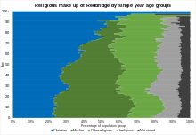
Ilford is a large town in east London, England, 9 miles (14 km) north-east of Charing Cross. Part of the London Borough of Redbridge, Ilford is within the ceremonial county of Greater London. It had a population of 168,168 in 2011, compared to 303,858 for the entire borough.

<span class="mw-page-title-main">Snaresbrook</span> Area of East London

Snaresbrook is a district in the London Borough of Redbridge, in East London. It is located eight miles east of Charing Cross.

<span class="mw-page-title-main">London Borough of Barking and Dagenham</span> London borough in United Kingdom

The London Borough of Barking and Dagenham is a London borough in East London. It lies around 9 miles (14.4 km) east of Central London. The borough was created in 1965 as the London Borough of Barking; the name was changed in 1980. It is an Outer London borough and the south is within the London Riverside section of the Thames Gateway; an area designated as a national priority for urban regeneration. At the 2011 census it had a population of 187,000. The borough's three main towns are Barking, Chadwell Heath and Dagenham. The local authority is the Barking and Dagenham London Borough Council. Barking and Dagenham was one of six London boroughs to host the 2012 Summer Olympics.

<span class="mw-page-title-main">Hainault, London</span> Area of east London

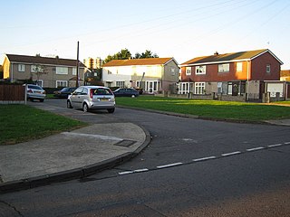
Hainault is a large suburban area in northeast London, England, in the London Borough of Redbridge, 12.5 miles (20.1 km) northeast of Charing Cross. Most of the housing in Hainault was built by the London County Council between 1947 and 1953. Originally spanning the parishes of Chigwell, Dagenham, and Ilford, in 1965 the estate was combined in a single London borough and became part of Greater London.

<span class="mw-page-title-main">Woodford Green</span> Human settlement in England

Woodford Green is an area of Woodford in East London, England, within the London Borough of Redbridge. It adjoins Buckhurst Hill to the north, Woodford Bridge to the east, South Woodford to the south, and Chingford to the west. Epping Forest runs through Woodford Green in the west of the area, 9.4 miles (15.1 km) north-east of Charing Cross.

<span class="mw-page-title-main">Chadwell Heath</span> Human settlement in England

Chadwell Heath is an area in East London, England. It is split between the London Borough of Barking and Dagenham and the London Borough of Redbridge, around 2 miles (3.2 km) west of Romford and 4 miles (6.4 km) east of Ilford, and 12 miles (19 km) north-east of Charing Cross.

<span class="mw-page-title-main">Gants Hill</span> Human settlement in England

Gants Hill is an area of Ilford in East London, England, within the borough of Redbridge. It is a suburb 9.5 miles (15.3 km) east northeast of Charing Cross. It lends its name to a central roundabout where five roads meet.

<span class="mw-page-title-main">Ilford North (UK Parliament constituency)</span> Parliamentary constituency in the United Kingdom, 1945 onwards

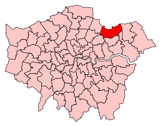
Ilford North is a constituency created in 1945 and represented in the House of Commons of the UK Parliament since 2015 by Wes Streeting of the Labour Party.

<span class="mw-page-title-main">Ilford South (UK Parliament constituency)</span> Parliamentary constituency in the United Kingdom, 1945 onwards

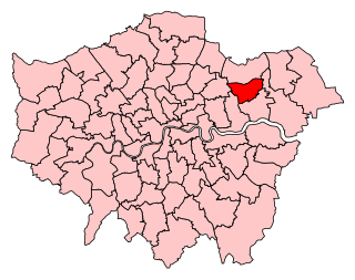
Ilford South is a constituency created in 1945 represented in the House of Commons of the UK Parliament since 2019 by Sam Tarry of the Labour Party.

<span class="mw-page-title-main">River Roding</span> River in Essex and Greater London, England

The River Roding rises at Molehill Green, Essex, England, then flows south through Essex and London and forms Barking Creek as it reaches the River Thames.

<span class="mw-page-title-main">Municipal Borough of Barking</span>

Barking was a local government district, and later civil parish and borough, in southwest Essex, England from 1882 to 1965. It was known as Barking Town from 1882 to 1931. The district included the town of Barking, eastern Beckton and the southwestern part of the Becontree estate. The district was within the Metropolitan Police District and experienced a steady increase in population during its existence. It now forms the western part of the London Borough of Barking and Dagenham and the eastern extremity of the London Borough of Newham in Greater London.

<span class="mw-page-title-main">Municipal Borough of Ilford</span> District in Essex, England

Ilford was a civil parish and local government district in south west Essex, England from 1888 to 1965, covering the town Ilford. The district saw a considerable rise in population throughout its life, caused by the expansion of the built-up area of London, and became one of the most populous districts of its type in England. The district now corresponds to the greater part of the London Borough of Redbridge in Greater London.

<span class="mw-page-title-main">Parks and open spaces in the London Borough of Redbridge</span>

The London Borough of Redbridge, one of the north-eastern peripheral London boroughs, has within its boundaries parts of two large open spaces: Epping Forest and Wanstead Flats. Apart from many smaller parks, gardens and sports grounds, the following are the main open spaces in Redbridge:

<span class="mw-page-title-main">Barkingside</span> Area of Ilford in east London, England

Barkingside is an area in Ilford, in the London Borough of Redbridge. It includes the major road junction of Fullwell Cross which also gives its name to the locality near that roundabout. The area is situated 10.6 miles (17km) north east of Charing Cross. Prior to 1965, it formed part of the borough of Ilford in the historic county of Essex.

<span class="mw-page-title-main">Municipal Borough of Wanstead and Woodford</span>

Wanstead and Woodford was a local government district from 1934 to 1965 in southwest Essex, England. A merger of two former urban districts, it was suburban to London and part of the Metropolitan Police District.

Wanstead and Woodford was a constituency in North East London represented in the House of Commons of the Parliament of the United Kingdom. It elected one Member of Parliament (MP) by the first past the post system of election. It existed between 1964 and 1997.

Fairlop is a suburban area of Ilford, in the London Borough of Redbridge in East London. Historically in Essex, it was part of the Municipal Borough of Ilford until 1965, when the rest of Ilford, including Fairlop, became part of Greater London. It lies adjacent to surrounding areas such as Loughton, Chigwell, Barkingside, Woodford.

<span class="mw-page-title-main">Woodford, London</span> Human settlement in England

Woodford is a town in East, London, within the London Borough of Redbridge. It is located 9.5 miles (15.3 km) north-east of Charing Cross. Woodford historically formed an ancient parish in the county of Essex. It contained a string of agrarian villages and was part of Epping Forest. From about 1700 onwards, it became a place of residence for affluent people who had business in London; this wealth, together with its elevated position, has led to it being called the Geographical and social high point of East London. Woodford was suburban to London and after being combined with Wanstead in 1934 it was incorporated as a municipal borough in 1937. It has formed part of Greater London since 1965 and comprises the neighbourhoods of Woodford Green, Woodford Bridge, Woodford Wells and South Woodford. The area is served by two stations on the Central line of the London Underground: Woodford and South Woodford.

<span class="mw-page-title-main">2010 Redbridge London Borough Council election</span> 2010 local election in England, UK

Elections for Redbridge London Borough Council were held on 6 May 2010. The 2010 General Election and other local elections took place on the same day.

References

  1. "London Places" (PDF). Greater London Authority. GLA. Archived from the original (PDF) on 6 September 2015. Retrieved 11 October 2015.
  2. Mills, A., Dictionary of London Place Names, (2001)
  3. "Claybury Woods and Park, including Repton Park". London Gardens Trust. Retrieved 10 May 2020.
  4. Historic England, "Valentines Park (1000843)", National Heritage List for England , retrieved 12 September 2017
  5. "Kenneth More Theatre". Vision RCL. Retrieved 10 May 2020.
  6. "Redbridge Museum". Hidden London. Retrieved 10 May 2020.
  7. "Redbridge Heritage Centre". Vision RCL. Retrieved 10 May 2020.
  8. "Embassy Cinema: The Restoration Project". Chadwell Heath South Residents' Association. Retrieved 5 August 2020.
  9. {{cite web|url=https://www.visionrcl.org.uk/libraries}
  10. "UK | England | London | Cycle centre 'first 2012 legacy'". BBC News. 19 August 2008. Retrieved 10 May 2020.
  11. History Of Barkingside FC Barkingside F.C.
  12. "Valentine's Park". Cricinfo. ESPN. Retrieved 22 September 2015.
  13. 1 2 3 "Population change 2001-2011". Office for National Statistics. 2012. Retrieved 30 November 2014.
  14. "Population statistics". Redbridge i. Redbridge Council. Archived from the original on 7 December 2014. Retrieved 30 November 2014.
  15. "2011 Census - Population". Redbridge i. Redbridge Council. Archived from the original on 7 December 2014. Retrieved 30 November 2014.
  16. "How long can you expect to live in 'Good' general health?". Office for National Statistics. 2014. Retrieved 30 November 2014.
  17. 1 2 3 4 "2011 Census - Diversity". Redbridge i. Redbridge Council. Archived from the original on 7 December 2014. Retrieved 30 November 2014.
  18. "Redbridge: Total Population". A Vision of Britain Through Time. Great Britain Historical GIS Project. Retrieved 6 September 2011.
  19. Equality, Commission for Racial (1985). "Ethnic minorities in Britain: statistical information on the pattern of settlement". Commission for Racial Equality: Table 2.2.
  20. "1991 census – theme tables". NOMIS. Retrieved 20 January 2017.
  21. "KS006 - Ethnic group". NOMIS. Retrieved 30 January 2016.
  22. "Ethnic Group by measures". NOMIS. Retrieved 8 January 2016.
  23. "Ethnic group - Office for National Statistics". www.ons.gov.uk. Retrieved 29 November 2022.
  24. "Religion - Religion in England and Wales: Census 2021, ONS".
  25. "Redbridge Census Results". Office of National Statistics.
  26. "Roding Valley Way". Sustrans.
  27. 1 2 3 4 5 6 Rose, Douglas (1999). The London Underground, A Diagrammatic History. London: Douglas Rose/Capital Transport. ISBN   1-85414-219-4. OCLC   59556887.
  28. "2011 Census: QS701EW Method of travel to work, local authorities in England and Wales". Office for National Statistics. Retrieved 23 November 2013. Percentages are of all residents aged 16-74 including those not in employment. Respondents could only pick one mode, specified as the journey’s longest part by distance.
  29. Great Britain Historical GIS / University of Portsmouth, Redbridge . Retrieved {{{accessdate}}}.
  30. "Redbridge Register Office (Redbridge Town Hall)". London Borough off Redbridge. Retrieved 10 May 2020.
  31. "The East London Boroughs (London Borough Boundaries) Order 1993".
  32. "The East London Boroughs (London Borough Boundaries) (No. 2) Order 1993".
  33. "The Redbridge and Waltham Forest (London Borough Boundaries) Order 1993".
  34. 1 2 "The Essex and Greater London (County Boundaries) Order 1993".
  35. "Top 10 most productive councils in England: 2018". iMPOWER. 22 November 2018. Retrieved 24 April 2019.
  36. "WHICH COUNCILS ARE BEST?" (PDF). iMPOWER. 22 November 2018. Archived (PDF) from the original on 24 April 2019. Retrieved 24 April 2019.
  37. "REDBRIDGE: Council election count - LIVE". East London and West Essex Guardian Series.
  38. "2010 local election ward results". Archived from the original on 10 May 2010. Retrieved 7 May 2010.
  39. "2006 Local election results". redbridge.gov.uk. Archived from the original on 10 May 2010. Retrieved 7 May 2010.
  40. GLA. "Archived copy" (PDF). Archived from the original (PDF) on 28 July 2011. Retrieved 31 January 2016.{{cite web}}: CS1 maint: archived copy as title (link), London Borough Council Elections May 2010, March 2011, accessed 21 April 2011.
  41. Boothroyd, David. "Greater London Council Election results: Redbridge". United Kingdom Election Results. Archived from the original on 24 March 2016. Retrieved 9 September 2023.
  42. "London's Poverty Profile". Trust for London. Retrieved 19 June 2018.
  43. Redbridge Music Service - Redbridge Schools' Choral Festival

51°34′N0°05′E / 51.567°N 0.083°E / 51.567; 0.083