Long Beach International Gateway

Last updated
Long Beach International Gateway
Long Beach International Gateway BG.jpg
Road deck of Long Beach International Gateway at night; 2022
Coordinates 33°45′54″N118°13′17″W / 33.76488°N 118.22130°W / 33.76488; -118.22130
Carries6 lanes of I-710 (1961).svg I-710, pedestrians and bicycles
Crosses Back Channel
Locale Terminal Island and Long Beach, California
Website newgdbridge.com
Preceded by Gerald Desmond Bridge (1968–2020)
Characteristics
Design Cable-stayed bridge
Total length8,800 ft (2,682 m)
Height515 ft (157 m)
Longest span1,000 ft (305 m)
Clearance below 205 ft (62 m)
History
ArchitectBrownlie Ernst and Marks
DesignerArup
Engineering design byArup
Constructed byShimmick/FCC/Impreglio (SFI) Joint Venture
Construction startJanuary 8, 2013 (2013-01-08)
Construction endOctober 2, 2020
Construction costest. US$1,500,000,000(equivalent to $1,851,890,000 in 2022)
OpenedOctober 5, 2020
Location
Long Beach International Gateway

The Long Beach International Gateway is a cable-stayed bridge that carries six lanes of Interstate 710 and a bicycle/pedestrian path in Long Beach, California, west across the Back Channel to Terminal Island. The bridge replaced the Gerald Desmond Bridge, which was completed in 1968 and named after Gerald Desmond, a prominent civic leader and a former city attorney for the City of Long Beach.

Contents

The 1968 steel arch bridge developed numerous issues, and the Port of Long Beach decided it would be best, from an economical perspective, that the bridge be replaced. After several years of studies, a cable-stayed bridge with 205 feet (62 m) of vertical clearance to be built north of the existing bridge was identified as the preferred alternative in the final environmental impact report (2010 FEIR). [1]

The new bridge allows access to the port for the tallest container ships after the older bridge is demolished. It is the first long-span cable-stayed bridge in California and the first and only cable-stayed bridge in the Los Angeles metropolitan area. [2] For the bridge to be so tall, long approaches were required to allow trucks to cross. [3] A joint venture of Parsons Transportation Group and HNTB performed preliminary engineering for the main span and the approaches. Earlier reports had studied and discarded various alternatives, including an alternative alignment with a new bridge south of the existing bridge, rehabilitation of the existing bridge, and a tunnel instead of an elevated bridge. [1]

Design

Illustration of the former Gerald Desmond Bridge and its cable-stayed replacement Gerald Desmond Bridge & Replacement.svg
Illustration of the former Gerald Desmond Bridge and its cable-stayed replacement

The 1968 roadway was four lanes (two in each direction) with a fifth climbing lane on each end. The replacement bridge carries a six-lane roadway with emergency lanes on each side, and the grade has been decreased by building a longer approach, despite the higher vertical clearance over the Back Channel; the planned improvements brought the bridge up to current freeway standards. [4] The replacement bridge also carries the Mark Bixby Memorial Bicycle-Pedestrian Path and observation decks over the water along the south side of the bridge. The path is named for Mark Bixby, a longtime proponent of adding bike lanes to the new Gerald Desmond Bridge replacement [5] [6] and a descendant of one of the original founders of Long Beach. Mark Bixby died in a March 2011 plane crash at the Long Beach Airport. [7]

The 1968 bridge was designated as a portion of Ocean Boulevard and was therefore operated by the City of Long Beach. When it opened to traffic on October 5, 2020, the replacement bridge was redesignated as the western (southern) extension of I-710 (extending its terminus to its intersection with State Route 47) and is now the responsibility of Caltrans, District 7. [4]

From west to east, the new bridge spans a total of 8,800 feet (2,700 m), consisting of: [8]

By extending the approach structures, approach grades are reduced to no more than 5 percent. [1]

As the tallest structure in the area, the 2020 cable-stayed bridge is a prominent addition to the Long Beach skyline. [9]

Construction

Helicopters hover 515 feet (157 m) above the ground during the January 8, 2013 groundbreaking ceremony, illustrating the height of the two cable towers in the planned replacement bridge. Port5 (8386386196).jpg
Helicopters hover 515 feet (157 m) above the ground during the January 8, 2013 groundbreaking ceremony, illustrating the height of the two cable towers in the planned replacement bridge.

The replacement bridge was unanimously approved by the City of Long Beach in late September 2010. [10] A project launch meeting was held at the Port of Long Beach on November 22, 2010, attended by Long Beach Mayor Bob Foster, U.S. Representatives Dana Rohrabacher and Laura Richardson, Senator Alan Lowenthal and Caltrans Director Cindy McKim. [4]

Caltrans, Port of Long Beach, and Metro officials reviewed seven potential engineering and construction firms, selecting four as qualified final lead bidders: [11]

Three of the pre-qualified bidders submitted proposals by March 2012, with Kiewit dropping out at the bid stage. [12] In May 2012, the Long Beach Board of Harbor Commissioners approved Port of Long Beach staff’s recommendation that the “best value” design-build proposal to replace the Gerald Desmond Bridge was submitted by the SFI joint venture team, comprising Shimmick Construction Company Inc., FCC Construction S.A. and Impregilo S.p.A., [13] and the contract was awarded to the SFI JV in July 2012. [14] Major participants in the joint venture also include Arup North America Ltd. and Biggs Cardosa Associates Inc. [15]

The project has been completed as a design-build in contrast to the traditional design-bid-build used typically in infrastructure improvement. [15]

During the groundbreaking ceremony on January 8, 2013, two helicopters hovered 515 feet (157 m) above ground level, illustrating the height of the two cable towers for the planned replacement bridge. [16]

The project was originally estimated to cost $800 million in 2008. [17] By 2010, costs had increased to $1.1 billion, [10] and funding identified in 2010 for the replacement bridge included $500 million contributed by Caltrans, $300 million contributed by the USDOT, $114 million from the Port of Long Beach, and $28 million from Metro. [4] As of 2016, the current project estimate is $1.5 billion. [2]

Construction issues

The new bridge was delayed shortly after breaking ground. The new piers were delayed by the relocation and/or removal of numerous old and active oil wells and utility lines, which prevented foundation work from beginning. The bridge is located in the midst of the Wilmington Oil Field, one of the most prolific oil-producing fields located in the United States. [18]

Another part of the cost increase and schedule delay is attributed to a 2013 redesign of the support towers. [19] Caltrans and the Port of Long Beach required the tower redesign, executed by the SFI joint venture, allegedly to ensure seismic safety and to preserve long term structural integrity. The redesign set the estimated completion of the bridge back by 12 to 18 months. [20] Other cost increases are attributed to extra oversight required by innovative, yet contractually compliant products and materials proposed by the designers of the replacement bridge. [2]

The roadway for the approach structures was supported during construction by an underlane self-launched movable scaffolding system (MSS), [21] and is the first project in California to use a MSS. [22] The MSS was designed to bridge the 235 ft (72 m) span between piers and to support the concrete as it was poured for each span. Once the concrete had cured, the MSS moved to the next pier and repeated the pour. The orange MSS was used on the western (Terminal Island) approach, and a similar blue MSS was used on the eastern approach. [22]

Construction progress

By October 2014, work had started on the pilings which would serve as foundations for the new bridge's piers. [23] The two cable-stay support towers were started in March (eastern tower) and April 2015 (western tower). [21] Approach spans were underway by April 2016. [22] By August 2016, the project had passed the halfway mark, and the two cable support towers were already more than 200 ft (61 m) high. [24] On December 5, 2017, a "topping-out" ceremony was held to celebrate the completion of the two cable support towers. [25] A virtual opening ceremony was held on October 2, 2020. Motor vehicle traffic opened in both directions on October 5, 2020, [26] but the bicycle/pedestrian path was not completed(...and has a locked gate at the Los Angeles border June 18, 2023) until July 17, 2021. [27]

Naming

For the first eight months after its opening, the bridge was called the Gerald Desmond Bridge Replacement. Mayor Robert Garcia and Assemblymember Patrick O'Donnell coordinated a community effort to decide if a new name was warranted. Family of Gerald Desmond and native Long Beach residents with former mayors Beverly O'Neill and Bob Foster favored keeping the original name; Foster felt a change would be disrespectful to the namesake of the original bridge, civic leader Gerald Desmond. [28]

In May 2021, Senator Lena Gonzalez and Assemblyman O'Donnell announced that the name "Long Beach International Gateway" had been chosen through a public survey [29]

See also

Related Research Articles

<span class="mw-page-title-main">Cable-stayed bridge</span> Type of bridge with cables directly from towers

A cable-stayed bridge has one or more towers, from which cables support the bridge deck. A distinctive feature are the cables or stays, which run directly from the tower to the deck, normally forming a fan-like pattern or a series of parallel lines. This is in contrast to the modern suspension bridge, where the cables supporting the deck are suspended vertically from the main cable, anchored at both ends of the bridge and running between the towers. The cable-stayed bridge is optimal for spans longer than cantilever bridges and shorter than suspension bridges. This is the range within which cantilever bridges would rapidly grow heavier, and suspension bridge cabling would be more costly.

<span class="mw-page-title-main">Goethals Bridge</span> Bridge between New Jersey and New York, United States

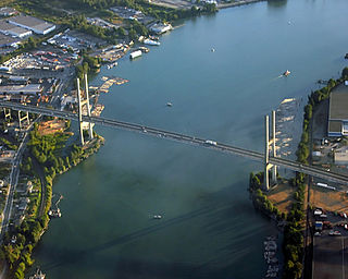
The Goethals Bridge is the name of a pair of cable-stayed bridge spans connecting Elizabeth, New Jersey, to Staten Island, New York, in the United States. The spans cross a strait known as Arthur Kill, and replaced a cantilever bridge span built in 1928. The bridge is operated by the Port Authority of New York and New Jersey.

<span class="mw-page-title-main">Interstate 710 and State Route 710 (California)</span> Interstate and state highway in California

Route 710, consisting of the non-contiguous segments of State Route 710 (SR 710) and Interstate 710 (I-710), is a major north–south state highway and auxiliary Interstate Highway in the Los Angeles metropolitan area of the U.S. state of California. Also called the Los Angeles River Freeway prior to November 18, 1954, the highway was initially planned to connect Long Beach and Pasadena, but a gap in the route exists from Alhambra to Pasadena through South Pasadena due to community opposition to its construction.

<span class="mw-page-title-main">Alex Fraser Bridge</span> Bridge in Delta, BC

The Alex Fraser Bridge is a cable-stayed bridge over the Fraser River that connects Richmond and New Westminster with North Delta in Greater Vancouver, British Columbia. The bridge is named for Alex Fraser, a former British Columbia Minister of Transportation. The bridge was the longest cable-stayed bridge in the world when it opened on September 22, 1986, and was the longest in North America until the Arthur Ravenel Jr. Bridge, in the U.S. state of South Carolina opened in 2005.

<span class="mw-page-title-main">Ting Kau Bridge</span> Bridge in New Territories, Hong Kong

Ting Kau Bridge is a 1,177-metre (3,862 ft) long cable-stayed bridge in Hong Kong that spans from the northwest of Tsing Yi Island and Tuen Mun Road. It is near the Tsing Ma Bridge which also serves as a major connector between the Hong Kong International Airport on Lantau Island and the rest of Hong Kong. It was completed on 5 May 1998. The bridge is toll-free.

<span class="mw-page-title-main">Vincent Thomas Bridge</span> Suspension bridge in Los Angeles, California, United States

The Vincent Thomas Bridge is a 1,500-foot-long (460 m) suspension bridge, crossing Los Angeles Harbor in Los Angeles, California, linking San Pedro with Terminal Island. It is the only suspension bridge in the Greater Los Angeles area. The bridge is part of State Route 47, which is also known as the Seaside Freeway. The bridge opened in 1963 and is named for California Assemblyman Vincent Thomas of San Pedro, who championed its construction. It was the first welded suspension bridge in the United States and is now the fourth-longest suspension bridge in California and the 76th-longest span in the world. The clear height of the navigation channel is approximately 185 feet (56 m); it is the only suspension bridge in the world supported entirely on piles.

<span class="mw-page-title-main">Eastern span replacement of the San Francisco–Oakland Bay Bridge</span> Seismic stabilization megaproject in California, United States (2002-2013)

The eastern span replacement of the San Francisco–Oakland Bay Bridge was a construction project to replace a seismically unsound portion of the Bay Bridge with a new self-anchored suspension bridge (SAS) and a pair of viaducts. The bridge is in the U.S. state of California and crosses the San Francisco Bay between Yerba Buena Island and Oakland. The span replacement took place between 2002 and 2013, and is the most expensive public works project in California history, with a final price tag of $6.5 billion, a 2,500% cost overrun from the original estimate of $250 million. Originally scheduled to open in 2007, several problems delayed the opening until September 2, 2013. With a width of 258.33 ft (78.74 m), comprising 10 general-purpose lanes, it is the world's widest bridge according to Guinness World Records.

<span class="mw-page-title-main">Stonecutters Bridge</span> Bridge in Hong Kong

Stonecutters Bridge is a high level cable-stayed bridge spanning the Rambler Channel in Hong Kong, connecting Nam Wan Kok, Tsing Yi to Stonecutters Island. The bridge deck was completed on 7 April 2009, and opened to traffic on 20 December that year. The bridge was the second-longest cable-stayed span in the world at the time of its completion.

<span class="mw-page-title-main">Port Mann Bridge</span> Bridge over the Fraser River in Metro Vancouver, British Columbia; opened in 2012

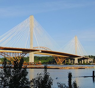
The Port Mann Bridge is a 10-lane cable-stayed bridge, 100 km/hr speed limit, in British Columbia, Canada that opened to traffic in 2012. It carries 10 lanes of traffic with space reserved for a light rail line.

<span class="mw-page-title-main">Extradosed bridge</span>

An extradosed bridge employs a structure that combines the main elements of both a prestressed box girder bridge and a cable-stayed bridge. The name comes from the word extrados, the exterior or upper curve of an arch, and refers to how the "stay cables" on an extradosed bridge are not considered as such in the design, but are instead treated as external prestressing tendons deviating upward from the deck. In this concept, they remain part of the main bridge superstructure.

<span class="mw-page-title-main">Bandra–Worli Sea Link</span> Bridge connecting Bandra Basitt and Worli, Mumbai, India

The Bandra-Worli Sea Link is a 5.6 km long, 8-lane wide bridge that links Bandra in the Western Suburbs of Mumbai with Worli in Central Mumbai. It is the longest sea bridge, as well as the 4th longest bridge in India after Bhupen Hazarika Setu, Dibang River Bridge and Mahatma Gandhi Setu. It is a cable-stayed bridge with pre-stressed concrete-steel viaducts on either side. It was planned as a part of the proposed Western Freeway that would link the Western Suburbs to Nariman Point in Mumbai's main business district, but is now planned to become part of the Coastal Road to Kandivali.

<span class="mw-page-title-main">Greenville Bridge</span> Bridge in United States of America

The Greenville Bridge, or the Jesse Brent Memorial Bridge, is a cable-stayed bridge over the Mississippi River, in the United States, carrying US 82 and US 278 between Refuge, Mississippi, and Shives, Arkansas. When it opened in 2010, it was the fourth-longest cable-stayed bridge in North America.

<span class="mw-page-title-main">Commodore Schuyler F. Heim Bridge</span> Bridge in Wilmington, California

The Commodore Schuyler F. Heim Bridge was a vertical-lift bridge in the Port of Los Angeles. Dedicated on January 10, 1948, the bridge allowed State Route 47 to cross over the Cerritos Channel. Named after Schuyler F. Heim, who was in command of the Naval Air Station on Terminal Island in 1942, the bridge was one of the largest vertical-lift bridges on the West Coast. At the time of its opening, it was the highest in the country with the deck weighing about 820 short tons. Its towers are 186 feet (57 m) tall above the roadway deck and about 236 feet (72 m) tall when measured from the water level at high water. The bridge was decommissioned on October 12, 2015 and replaced by a new, six-lane fixed-span bridge in order to meet current safety and earthquake standards. A replacement bridge, tentatively titled State Route 47 Schuyler Heim Bridge Replacement, was completed in September 2020.

<span class="mw-page-title-main">Gerald Desmond Bridge</span> Through arch bridge in Long Beach, California (1968–2020)

The Gerald Desmond Bridge was a 1968 through arch bridge that carried five lanes of Ocean Boulevard from Interstate 710 in Long Beach, California, west across the Back Channel to Terminal Island. The bridge was named after Gerald Desmond, a prominent civic leader and former city attorney for the City of Long Beach. In October 2020, a new cable-stayed bridge named Long Beach International Gateway replaced the old Gerald Desmond Bridge due to insufficient vertical clearance for shipping, Demolition of the old bridge is expected to be completed in 2023.

<span class="mw-page-title-main">Prai River Bridge</span> Bridge in Perai, Butterworth Outer Ring Road

Perai River Bridge is a dual-three lane cable stayed bridge connecting the banks of the Perai River in Perai, Penang, Malaysia. It is part of the Butterworth Outer Ring Road (BORR).

<span class="mw-page-title-main">Incheon Bridge</span> Bridge in Incheon, South Korea

The Incheon Bridge is a reinforced concrete cable-stayed bridge in South Korea. At its opening in October 2009, it became the second bridge connection between Yeongjong Island and the mainland of Incheon. The Incheon Bridge is South Korea's longest spanning cable-stayed bridge. In comparison, it is the world's tenth longest cable-stayed bridge as of January 2019.

Gerald Desmond was a prominent Democratic politician and civic leader in Long Beach, California who served as a Long Beach City Councilmember and as Long Beach City Attorney.

<span class="mw-page-title-main">Queensferry Crossing</span> Road bridge across the Firth of Forth, Scotland

The Queensferry Crossing is a road bridge in Scotland. It was built alongside the existing Forth Road Bridge and the Forth Bridge. It carries the M90 motorway across the Firth of Forth between Edinburgh, at South Queensferry, and Fife, at North Queensferry.

<span class="mw-page-title-main">Vidyasagar Setu</span> Cable-stayed toll bridge in West Bengal, India

Vidyasagar Setu, also known as the Second Hooghly Bridge, is a toll bridge over the Hooghly River in West Bengal, India, linking the cities of Kolkata and Howrah.

<span class="mw-page-title-main">Movable scaffolding system</span> Self-launching form used in bridge construction

A movable scaffolding system (MSS) is a special-purpose self-launching form used in bridge construction, specifically prestressed concrete bridges with segments or spans that are cast in place. The movable scaffolding system is used to support a form while the concrete is cured; once the segment is complete, the scaffold and forms are moved to the end of the new segment and another segment is poured.

References

  1. 1 2 3 4 5 Parsons–HNTB Joint Venture (July 2010). Gerald Desmond Bridge Replacement Project: Final Environmental Impact Report / Environmental Assessment & Application Summary Report (PDF) (Report). Port of Long Beach and Caltrans. Retrieved November 21, 2016.
  2. 1 2 3 Ortega, Norma (October 19–20, 2016). "Supplemental funds allocation for Gerald Desmond Bridge design-build project resolution FA-16-07" (PDF). Letter to Chair and Commissioners, California Transportation Commission. Retrieved November 21, 2016.
  3. Stocking, Angus (June 18, 2014), "Innovative System Ensures Vertical Alignment of Gerald Desmond Bridge", Point of Beginning, Troy, Michigan: BNP Media
  4. 1 2 3 4 Gish, Judy (December 2010). "New Gerald Desmond: a Bridge to California's Economic Future". InsideSeven. Caltrans District 7. Retrieved November 21, 2016.
  5. 2015 Named Freeways, Highways, Structures and Other Appurtenances in California (Report). California Department of Transportation. 2016. p. 143. Mark Bixby Memorial Bicycle Pedestrian Path
  6. California State Assembly. "Assembly Concurrent Resolution No. 100". Session of the Legislature. Statutes of California (Resolution). State of California. Ch. 109. "Assembly Concurrent Resolution No. 100". 2012. Retrieved November 21, 2016.
  7. Barboza, Tony (March 16, 2011). "Long Beach plane crash claims community leaders, member of founding Bixby family [BLOG]". Los Angeles Times. Retrieved November 21, 2016.
  8. "New Bridge at a Glance". New Gerald Desmond Bridge. 2016. Retrieved November 22, 2016. Note 1: WEST APPROACH: The 2,800-ft. west approach will be on Terminal Island.
    Note 7: TOWERS: At 515 feet tall, the bridges two towers will be the second-tallest of any cable-stayed bridge in the U.S. The steel-reinforced concrete towers will be supported by massive foundations. The tower design – unique to this bridge – transitions from an octagon shape at the base to diamond shape at the top.
    Note 8: CABLE-STAYED BRIDGE: The new bridge is a cable-stayed design, in which cables directly connect the towers to the road deck (unlike a traditional suspension bridge, which uses cables draped over towers). The entire length of the bridge – main span and approaches – will be 8,800 feet.
    Note 9: SPAN: The main span and back spans of the bridge will be 2,000 feet long and 205 feet above the water. It will be the highest deck of any cable-stayed bridge in the U.S.
    Note 10: EAST APPROACH: The 3,600-ft. east approach will connect the bridge to both the Long Beach (710) Freeway and east Ocean Boulevard toward downtown Long Beach.
    [ permanent dead link ]
  9. Cho, Aileen (June 12, 2019). "Gerald Desmond Bridge Nears Completion". Engineering News-Record. Retrieved June 14, 2019.
  10. 1 2 Zummallen, Ryan (September 29, 2010). "Gerald Desmond Bridge Construction Approved By Long Beach City Council". Long Beach Post. Archived from the original on November 23, 2016. Retrieved November 22, 2016.
  11. "Caltrans, Port Select Bidders for Bridge Project" (Press release). Port of Long Beach. March 4, 2011. Retrieved December 5, 2016.[ permanent dead link ]
  12. "Caltrans, Port Receive Bridge Replacement Proposals" (Press release). Port of Long Beach. March 2, 2012. Retrieved December 5, 2016.
  13. "Commission OKs Desmond Bridge Recommendation" (Press release). Port of Long Beach. May 16, 2012. Retrieved December 5, 2016.
  14. "Harbor Commission Awards Bridge Design-Build Contract" (Press release). Port of Long Beach. July 23, 2012. Retrieved November 22, 2016.
  15. 1 2 "Port of Long Beach approves bridge replacement". Bridge Design & Engineering. August 10, 2010. Retrieved August 16, 2010.[ permanent dead link ]
  16. Gish, Judy. "Building Bridges, Raising Economies". InsideSeven. Caltrans District 7. Retrieved October 21, 2016.
  17. "Strategic Oversight Agreement for Gerald Desmond Bridge Replacement" (PDF). Caltrans. February 21, 2008. Retrieved November 21, 2016. PROJECT DESCRIPTION
    This project consists of replacement of the aging Gerald Desmond Drive. The project location is in the Back Channel area of the Port of Long Beach, centered along Ocean Blvd. From the intersection of the Terminal Island Freeway (SR-47) at the western end to its terminus at the westerly end of the bridge over the Los Angeles River. The total project cost is estimated to be $721,400,000 subject to escalation from a base November 2005 dollar. Project cost will be revised at environmental certification scheduled for third quarter of 2008. Caltrans fact sheet for project shows construction costs of $800,500,000 with $65,000,000 support costs.
  18. Robes Meeks, Karen (October 5, 2013). "Maze of oil wells, utility lines complicates Gerald Desmond Bridge project". Long Beach Press Telegram. Retrieved December 6, 2016.
  19. Edwards, Andrew (July 14, 2015). "Price tag to replace Gerald Desmond Bridge in Long Beach jumps by more than $200 million". Long Beach Press-Telegram.
  20. Robes Meeks, Karen (June 24, 2014). "Design issues delay Gerald Desmond Bridge replacement project". Long Beach Press Telegram. Retrieved December 6, 2016.
  21. 1 2 Edwards, Andrew (April 22, 2015). "Workers laying foundation for the new Gerald Desmond Bridge in Long Beach". Long Beach Press Telegram. Retrieved December 6, 2016.
  22. 1 2 3 Edwards, Andrew (April 18, 2016). "How high-tech scaffolding is helping build Gerald Desmond Bridge in Long Beach". Long Beach Press Telegram. Retrieved December 6, 2016.
  23. Robes Meeks, Karen (October 1, 2014). "Gerald Desmond Bridge project milestone marked by city, Port of Long Beach officials". Long Beach Press Telegram. Retrieved December 6, 2016.
  24. Aragon, Greg (August 3, 2016). "Construction on $1.2- billion Gerald Desmond Bridge Project Passes Halfway Point". Engineering News-Review [blog]. Retrieved December 6, 2016.
  25. Ruiz, Jason (December 6, 2017). "Twin 515-foot Columns Completed as City Celebrates "Topping Off" of New Gerald Desmond Bridge". Long Beach Post. Archived from the original on February 17, 2018. Retrieved February 16, 2018.
  26. "New Bridge Scheduled to Open Oct. 5". The Gerald Desmond Bridge. 2020-09-26. Retrieved 2020-09-28.
  27. Echeverry, Sebastian (2021-07-17). "'A great honor': Family, friends of the late Mark Bixby tour new bike path named in his honor". Long Beach Post News. Retrieved 2021-08-07.
  28. Rich Archbold (26 September 2020). "Who was Gerald Desmond, and why was a bridge named after him?". Press Telegram.
  29. "New Port Bridge Gets A Name: Long Beach International Gateway". City News Service. Long Beach. May 24, 2021. Retrieved May 28, 2021.