Technical and further education or simply TAFE, is the common name in English-speaking countries in Oceania for vocational education, as a subset of tertiary education. TAFE institutions provide a wide range of predominantly vocational courses.

The University of Adelaide is a public research university located in Adelaide, South Australia. Established in 1874, it is the third-oldest university in Australia. The university's main campus is located on North Terrace in the Adelaide city centre, adjacent to the Art Gallery of South Australia, the South Australian Museum, and the State Library of South Australia.

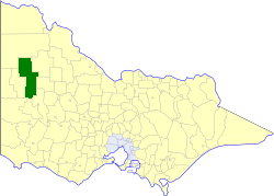
The Shire of Yarriambiack is a local government area of Victoria, Australia, located in the north-western part of the state. It covers an area of 7,326 square kilometres (2,829 sq mi) and, in June 2018, had a population of 6,658, having fallen from 7,438 in 2008. It includes the towns of Hopetoun, Murtoa, Rupanyup and Warracknabeal. It was formed in 1995 from the amalgamation of the Shire of Warracknabeal, Shire of Karkarooc, and parts of the Shire of Dunmunkle and Shire of Wimmera.

The Victorian government's Wimmera Southern Mallee subregion is part of the Grampians region in western Victoria. It includes most of what is considered the Wimmera, and part of the southern Mallee region. The subregion is based on the social catchment of Horsham, its main settlement.

Warracknabeal is a wheatbelt town in the Australian state of Victoria. Situated on the banks of the Yarriambiack Creek, 330 km northwest of Melbourne, it is the business and services centre of the northern Wimmera and southern Mallee districts, and hosts local government offices of the Shire of Yarriambiack. At the 2011 census, Warracknabeal district had a population of 2,745, of which 2,340 lived in the town.

Horsham is a regional city in the Wimmera region of western Victoria, Australia. Located on a bend in the Wimmera River, Horsham is approximately 300 kilometres (190 mi) northwest of the state capital Melbourne. As of the 2021 census, Horsham had a population of 20,429. It is the most populous city in Wimmera, and the main administrative centre for the Rural City of Horsham local government area. It is the eleventh largest city in Victoria after Melbourne, Geelong, Ballarat, Bendigo, Wodonga, Mildura, Shepparton, Warrnambool, Traralgon, and Wangaratta.

The Royal Agricultural University (RAU), formerly the Royal Agricultural College, is a public university in Cirencester, Gloucestershire, England. Established in 1845, it was the first agricultural college in the English-speaking world. The university provides more than 30 land-based undergraduate and postgraduate programmes to students from over 45 countries through the School of Agriculture, the School of Business and Entrepreneurship, the School of Equine and the School of Real Estate and Land Management.
Melbourne Polytechnic, formerly NMIT, is an institute of higher education and vocational education (TAFE) located in Melbourne, Australia that has been operating since around 1910.
The University of Ballarat, Australia was a dual-sector university with multiple campuses in Victoria, Australia, including its main Ballarat campus, Melbourne, Sydney, and Adelaide that were authorized by the university to provide diploma, undergraduate and postgraduate programs. The university offered traditional programs, including business, information technology, building and construction, engineering, mining, education, social sciences, nursing, hospitality, and art.
Dooen is a small town situated in the Wimmera region, Western Victoria, Australia. The Henty Highway between Mildura and Portland passes through the tiny town. At the 2021 census, Dooen had a population of 250.
3WM is a radio station based in Horsham in the Wimmera Mallee region of Victoria, Australia. It broadcasts on the AM band, at a frequency of 1089 kHz, and on the FM band around Ararat at a frequency of 96.1 MHz.
Marcus Oldham College is an agricultural, equine and farm management tertiary education institution located in Geelong, Victoria and is the only private agricultural college operating in Australia. Founded in 1962, the institution attracts enrolments from domestic and international students.
The Shire of Dimboola was a local government area in the Wimmera region of western Victoria, Australia. The shire covered an area of 4,856 square kilometres (1,874.9 sq mi), and existed from 1885 until 1995.

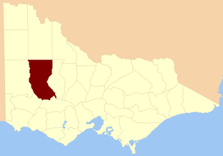
The Shire of Wimmera was a local government area in the Wimmera region of western Victoria, Australia. The municipality covered an area of 2,611 square kilometres (1,008.1 sq mi), and existed from 1862 until 1995. Although its shire offices were located in Horsham, Horsham itself was governed by a separate council after it succeeded in 1882.
Peter Stanley Fisher is a former Australian politician. Born in Rainbow, Victoria, he attended Longerenong Agricultural College before becoming a farmer. In 1972, he was elected to the Australian House of Representatives as the Country Party member for Mallee. During his parliamentary career, Fisher served as Deputy Whip (1976-1980), Chief Whip (1980-1983) and Shadow Minister for Sport and Recreation (1983-1984). Fisher held the seat until 1993. In 1979, the first Qantas Boeing 747 aircraft equipped with Rolls-Royce engines was named the 'City of Swan Hill' after the riverside Mallee town as a result of Fisher's lobbying efforts.
The County of Borung is one of the 37 counties of Victoria which are part of the cadastral divisions of Australia, used for land titles. The northern boundary of the county is at 36°S. At the north its western boundary is 142°E, its eastern boundary is 143°E. Larger towns include Dimboola, Warracknabeal, Horsham and Stawell. The county was proclaimed in 1871 together with the other counties of the Wimmera Land District. The county was proclaimed in 1871.

The electoral district of Wimmera was an electoral district of the Legislative Assembly in the Australian state of Victoria.
Dimboola Memorial Secondary College is a public, co-educational secondary school day school located in Dimboola, Victoria, Australia. It is a small country secondary college with about 200 students and was originally erected as a memorial to those who fought in the First World War. It is located on a hill overlooking Dimboola and the Little Desert. The school's motto is "Facta Non Verba", meaning 'by deeds and not words'. The school is unique in that it is the only purpose-built memorial school in Victoria, and honours Dimboola residents who made the ultimate sacrifice during World War I.

Scotland's Rural College (SRUC) is a public land based research institution focused on agriculture and life sciences. Its history stretches back to 1899 with the establishment of the West of Scotland Agricultural College and its current organisation came into being through a merger of smaller institutions.

Federation University Australia is a public, multi-sector university based in Ballarat in Victoria, Australia. The university also has campuses in Ararat, Horsham, Stawell, Churchill, Berwick, and Brisbane, as well as online technical and further education (TAFE) courses and Horsham's higher education nursing program.