
The Tasman Sea is a marginal sea of the South Pacific Ocean, situated between Australia and New Zealand. It measures about 2,000 km (1,200 mi) across and about 2,800 km (1,700 mi) from north to south. The sea was named after the Dutch explorer Abel Janszoon Tasman, who in 1642 was the first known person to cross it. British explorer Lieutenant James Cook later extensively navigated the Tasman Sea in the 1770s during his three voyages of exploration.

The Bristol Type 170 Freighter is a British twin-engine aircraft designed and built by the Bristol Aeroplane Company as both a freighter and airliner. Its best known use was as an air ferry to carry cars and their passengers over relatively short distances. A passenger-only version was also produced, known as the Wayfarer.

The Douglas C-54 Skymaster is a four-engined transport aircraft used by the United States Army Air Forces in World War II and the Korean War. Like the Douglas C-47 Skytrain derived from the DC-3, the C-54 Skymaster was derived from a civilian airliner, the Douglas DC-4. Besides transport of cargo, the C-54 also carried presidents, prime ministers, and military staff. Dozens of variants of the C-54 were employed in a wide variety of non-combat roles such as air-sea rescue, scientific and military research, and missile tracking and recovery. During the Berlin Airlift it hauled coal and food supplies to West Berlin. After the Korean War it continued to be used for military and civilian uses by more than 30 countries. It was one of the first aircraft to carry the President of the United States, the first being President Franklin D. Roosevelt during World War II.
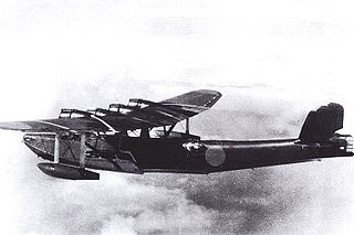
The Kawanishi H6K was an Imperial Japanese Navy flying boat produced by the Kawanishi Aircraft Company and used during World War II for maritime patrol duties. The Allied reporting name for the type was Mavis; the Navy designation was "Type 97 Large Flying Boat" (九七式大型飛行艇). Developed in the 1930s, it was used for reconnaissance, transport, bombing, naval warfare, and executive transport by the Imperial Japanese Navy. The national airline also used it as commercial airliner. The British mistakenly identified this aircraft as the Kawanishi Navy 97 Mavis.

Lord Howe Island is an irregularly crescent-shaped volcanic remnant in the Tasman Sea between Australia and New Zealand, part of the Australian state of New South Wales. It lies 600 km (320 nmi) directly east of mainland Port Macquarie, 780 km (420 nmi) northeast of Sydney, and about 900 km (490 nmi) southwest of Norfolk Island. It is about 10 km (6.2 mi) long and between 0.3 and 2.0 km wide with an area of 14.55 km2, though just 3.98 km2 of that comprise the low-lying developed part of the island.

Gold Coast Airport is a domestic and international Australian airport located at the southern end of the Gold Coast and approximately 90 km (56 mi) south of Brisbane, within the South East Queensland agglomeration. The entrance to the airport is situated in the suburb of Bilinga near Coolangatta. The main runway itself cuts through the state borders of Queensland and New South Wales. During summer, these states are in two different time zones. The Gold Coast Airport operates on Queensland Time.

The Short S.25 Sandringham is a British civilian flying boat designed and originally produced by Short Brothers. They were produced as conversions of the widely used Short Sunderland, a military flying boat that was commonly used as a maritime patrol aircraft.

Sunshine Coast Airport is an Australian international airport located in Marcoola, 10 km (6.2 mi) north of Maroochydore, at the northern end of the Sunshine Coast. It is approximately 90 km (56 mi) north of centre of Brisbane, within the South East Queensland agglomeration. The airport is owned by Sunshine Coast Regional Council and is the principal and only jet-capable airport serving an urban area of nearly 400,000 residents.

The Lord Howe Rise is a deep sea plateau which extends from south west of New Caledonia to the Challenger Plateau, west of New Zealand in the south west of the Pacific Ocean. To its west is the Tasman Basin and to the east is the New Caledonia Basin. Lord Howe Rise has a total area of about 1,500,000 km2 (580,000 sq mi), and generally lies about 750 to 1,200 metres under water. It is part of Zealandia, a much larger continent that is now mostly submerged, and so is composed of continental crust. Some have included the 3,500 m (11,500 ft) deep New Caledonia Basin as within the rise, given its continental crust origin, and this would give a larger total area of 1,950,000 km2 (750,000 sq mi).

Norfolk Island Airport, also referred to as Norfolk Island International Airport, is the only airport on Norfolk Island, an external territory of Australia. The island is located in the Pacific Ocean between Australia, New Zealand, and New Caledonia. The airport is operated by the Norfolk Island Regional Council, and is on the west side of the island.

Newcastle Airport is an international airport in Williamtown, New South Wales. It is located 15 kilometres; 9.2 miles (8 NM) north of Newcastle in Port Stephens. It is the 13th busiest airport in Australia, handling over 1.25 million passengers in the year ended 30 June 2017, an increase of 6.6% on the previous year. The airport occupies a 28 ha (69-acre) site on the southern border of RAAF Base Williamtown.
Kaitaia Airport is an airport located 5km Northeast of Kaitaia, in the Far North District of New Zealand. The land the airport is situated on is owned by Crown and leased to the Far North District Council (FNDC), who contracts Far North Holdings Limited (FNHL) to manage the aerodrome.

Christmas Island International Airport is an airport located on Christmas Island, a territory of Australia in the Indian Ocean. The island is located 2,600 km (1,600 mi) northwest of the Western Australian city of Perth, 500 km (310 mi) south of the Indonesian capital, Jakarta, and 975 km (606 mi) east-northeast of the Cocos (Keeling) Islands.

The DH.83 Fox Moth is a small biplane passenger aircraft from the 1930s powered by a single de Havilland Gipsy Major I inline inverted engine, manufactured by the de Havilland Aircraft Company.

The de Havilland DH.50 was a 1920s British large single-engined biplane transport built by de Havilland at Stag Lane Aerodrome, Edgware, and licence-built in Australia, Belgium, and Czechoslovakia.
Moree Airport is an airport in Moree, New South Wales, Australia. The airport is 5 km (3.1 mi) from the city center. The airport has some scheduled services but mainly provides general aviation facilities, maintenance and support for agricultural aviation in the local area. The Moree Aero Club has been based at the airport since 1952, and today provides aircraft hire and flight training. The club was instrumental in providing many early improvements to the aerodrome facilities, including hangars and a terminal building. In the 2021-22 Financial Year, Moree Airport handled 18,073 passengers, down from approximately 35,000 per year before travel restrictions were introduced as a result of the response to the COVID-19 pandemic.
Kerikeri Airport, also known as Bay of Islands Airport, is an airport at Kerikeri, New Zealand. It is a ten-minute drive from Kerikeri and a 50-minute flight to and from Auckland Airport.

Cassidy International Airport is an airport located north of Banana, a settlement on Kiritimati island in Kiribati. Until 2018, it was the only airport in the Kiribati part of the Line Islands with an IATA or ICAO code.

Zealandia, also known as Te Riu-a-Māui (Māori) or Tasmantis, is an almost entirely submerged mass of continental crust in Oceania that subsided after breaking away from Gondwana 83–79 million years ago. It has been described variously as a submerged continent, continental fragment, and microcontinent. The name and concept for Zealandia was proposed by Bruce Luyendyk in 1995, and satellite imagery shows it to be almost the size of Australia. A 2021 study suggests Zealandia is over a billion years old, about twice as old as geologists previously thought.

Rottnest Island Airport is a small airport for light aircraft, situated about 800 m (2,600 ft) from the main settlement at Thomson Bay, Rottnest Island and 10 nautical miles northwest of Fremantle. Daily air services operate to the island. In the past these have been from Perth Airport, but in recent years have been mainly from Jandakot.


