In Gaelic myth, the Cailleach is a divine hag and ancestor, associated with the creation of the landscape and with the weather, especially storms and winter. The word literally means 'old woman, hag', and is found with this meaning in modern Irish and Scottish Gaelic, and has been applied to numerous mythological and folkloric figures in Ireland, Scotland, and the Isle of Man. In modern Irish folklore studies, she is sometimes known as The Hag of Beara, while in Scotland she is known as Beira, Queen of Winter.
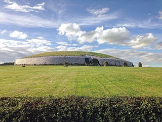
Newgrange is a prehistoric monument in County Meath in Ireland, located on a rise overlooking the River Boyne, 8 kilometres (5.0 mi) west of Drogheda. It is an exceptionally grand passage tomb built during the Neolithic Period, around 3200 BC, making it older than Stonehenge and the Egyptian pyramids. It is aligned on the winter solstice sunrise. Newgrange is the main monument in the Brú na Bóinne complex, a World Heritage Site that also includes the passage tombs of Knowth and Dowth, as well as other henges, burial mounds and standing stones.

The River Boyne is a river in Leinster, Ireland, the course of which is about 112 kilometres (70 mi) long. It rises at Trinity Well, Newberry Hall, near Carbury, County Kildare, and flows towards the Northeast through County Meath to reach the Irish Sea between Mornington, County Meath, and Baltray, County Louth.
Dowth is a Neolithic passage tomb located in the Boyne Valley, County Meath, Ireland. It is one of the three principal tombs of the Brú na Bóinne World Heritage Site – a landscape of prehistoric monuments including the large passage-tombs of Dowth, Dowth Hall, Newgrange and Knowth. Unlike Newgrange and Knowth, Dowth has not been independently dated, but its features align it with the other passage tombs which date from between approximately 3200 and 2900 BC. However, Harbison (1970) dates the tomb at 2500 – 2000 BC. It is less developed as a tourist attraction than its neighbours, partly because the chamber is much lower, and partly because the decoration is less visible. It was partly excavated in 1847 by the Royal Irish Academy, who dynamited the roof, causing the still-visible crater, although the site was pillaged by Vikings and earlier looters long before that.

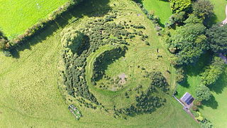
Knowth is a Neolithic passage grave and an ancient monument of the World Heritage Site of Brú na Bóinne located 8.4 km west of Drogheda in Ireland's valley of the River Boyne. It is the largest passage grave of the Brú na Bóinne complex. It consists of a large mound and 17 smaller satellite tombs. The mound is about 12 metres (40 ft) high and 67 metres (220 ft) in diameter, covering roughly a hectare. It contains two passages placed along an east-west line and is encircled by 127 kerbstones, of which three are missing, and four badly damaged.
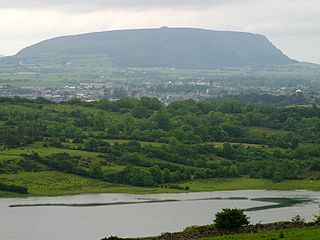
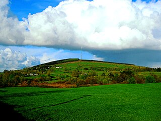
Knocknarea is a large prominent hill west of Sligo town in County Sligo, Ireland, with a height of 327 metres (1,073 ft). Knocknarea is visually striking as it has steep limestone cliffs and stands on the Cúil Irra peninsula overlooking the Atlantic coast. At the summit is one of Ireland's largest cairns, known as Queen Maeve's Cairn, which is believed to contain a Neolithic passage tomb. In recent years there has been concern that the ancient cairn, a protected National Monument, is being damaged by climbers. There are also remains of several smaller tombs on the summit. Knocknarea overlooks the Carrowmore tombs and is thought to have been part of an ancient ritual landscape.

Brú na Bóinne (Irish:[ˈbˠɾˠuːn̪ˠəˈbˠoːn̠ʲə]; Palace of the Boyne or Boyne Valley Tombs, is an area in County Meath, Ireland, located in a bend of the River Boyne. It contains one of the world's most important prehistoric landscapes dating from the Neolithic period, including the large Megalithic passage graves of Knowth, Newgrange and Dowth as well as some 90 additional monuments. The archaeological culture associated with these sites is called the "Boyne culture".

The Newgrange cursus is a Neolithic monument used as a ceremonial procession route within the Brú na Bóinne complex. The ancient trackway is 100m long and 20m wide. It is located at Newgrange, in County Meath, Ireland.

Monknewtown, historically called Rathenskin, is a townland 3 km east of Slane in County Meath, Ireland. It stands on the right bank of the Mattock River, which feeds several historic watermills nearby and which forms approximately the townland's eastern boundary with Keerhan and Sheepgrange townlands in County Louth. Neighbouring townlands to the south are Balfeddock, Knowth, and Crewbane, to the west Cashel, Mooretown, and Knockmooney. The northern boundary of Monknewtown with Kellystown is formed by a tributary of the Mattock River, while the southern boundary is formed by the N51 road. Other than the latter, only minor roads traverse the townland, among them L5606 from west to east.

The Brú na Bóinne Visitor Centre is the starting point for all visits to the monuments of the UNESCO World Heritage Site at Brú na Bóinne, notably the passage graves of Newgrange and Knowth. It is located eight kilometers west of Drogheda in County Meath, Ireland.

Slieve Gullion is a mountain in the south of County Armagh, Northern Ireland. The mountain is the heart of the Ring of Gullion and is the highest point in the county, with an elevation of 573 metres (1,880 ft). At the summit is a small lake and two ancient burial cairns, one of which is the highest surviving passage grave in Ireland. Slieve Gullion appears in Irish mythology, where it is associated with the Cailleach and the heroes Fionn mac Cumhaill and Cú Chulainn. It dominates the countryside around it, offering views as far away as Antrim, Dublin Bay and Wicklow on a clear day. Slieve Gullion Forest Park is on its eastern slope.
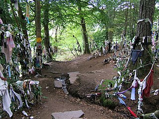
A clootie well is a holy well, almost always with a tree growing beside it, where small strips of cloth or ribbons are left as part of a healing ritual, usually by tying them to branches of the tree. Clootie wells are places of pilgrimage usually found in Celtic areas. It is believed the tradition comes from the ancient custom of leaving votive offerings in water. In Scots, a clootie or cloot is a strip of cloth or rag.

Gavrinis is a small island in the Gulf of Morbihan in Brittany, France. It contains the Gavrinis tomb, a megalithic monument notable for its abundance of megalithic art in the European Neolithic. Administratively, it is part of the commune of Larmor-Baden.

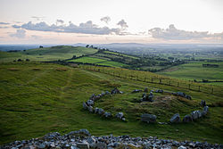
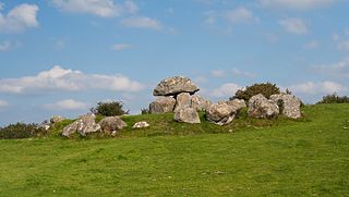
Slieve na Calliagh are a range of hills and ancient burial site near Oldcastle, County Meath, Ireland. The summit is 276 metres (906 ft), the highest point in the county. On the hilltops are about twenty passage tombs, some decorated with rare megalithic art, which were built in the 4th millennium BC. Also called the Loughcrew tombs, it is one of the main passage tomb cemeteries in Ireland, along with Brú na Bóinne, Carrowkeel and Carrowmore.

Miosgán Meadhbha, anglicized Miosgan Meva and also called Maeve's Cairn, is a large cairn on the summit of Knocknarea in County Sligo, Ireland. It is thought to conceal a passage tomb from the Neolithic. It is the largest cairn in Ireland, excepting those at Brú na Bóinne in Meath.

Knockmany passage tomb, or Anya's Cove, is an ancient burial monument on the summit of Knockmany Hill, near the village of Augher in County Tyrone, Northern Ireland. It is the remains of a Neolithic passage tomb and its stones are decorated with rare megalithic art. They are protected by a concrete chamber and mound, built in 1959 by the Department of the Environment, roughly resembling the mound that would have originally covered it. The stones can be viewed through the entrance gates. It is a monument in state care.
Passage tombs are a category of Megalithic monument from the Neolithic period. They are found in most regions of Ireland but are more prevalent in the Northern half of the island. The usage period of Irish passage tombs date from c. 3750 B.C. to about 2500 B.C. About twenty clusters are recorded in Ireland, but the best known examples are found along a curved trajectory from the west coast to the east, including the centres of Carrowmore and Carrowkeel in County Sligo, and Loughcrew and the Boyne Valley in County Meath.