
Aura is a municipality of Finland. The name derives from the river Aura and the plough reminiscent shape of the municipality. The municipality was established in 1917 from parts of Lieto and Pöytyä.

Vaala is a municipality in Finland. It is located in the North Ostrobothnia region. Established in 1954, the municipality has a population of 2,589 and covers an area of 1,764.04 square kilometres (681.10 sq mi) of which 461.45 km2 (178.17 sq mi) is water. The population density is 1.99 inhabitants per square kilometre (5.2/sq mi). Previously Vaala was part of the Kainuu region but was transferred to Northern Ostrobothnia on 1 January 2016.

Taivalkoski is a municipality of Finland, it is located in the Province of Oulu and is part of the Northern Ostrobothnia region.
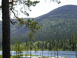
Kolari is a municipality of Finland at the Swedish border, which follows the Torne River, the longest free-flowing river in Europe.

Pelkosenniemi is a municipality of Finland. It is located in the province of Lapland. The municipality has a population of 912 (31 December 2023), which make it the smallest municipality in Lapland in terms of population. It covers an area of 1,881.58 square kilometres (726.48 sq mi) of which 45.4 km2 (17.5 sq mi) is water. The population density is 0.5 inhabitants per square kilometre (1.3/sq mi). Neighbour municipalities are Kemijärvi, Rovaniemi, Salla, Savukoski and Sodankylä.
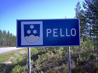
Pello is a municipality of Finland. It is located approximately 20 kilometres (12 mi) north of the Arctic Circle in the western part of the province of Lapland, and is part of the Lapland region. The municipality is on the national border with Sweden, by the Tornionjoki-river. The municipality has a population of 3,253 and covers an area of 1,864.66 square kilometres (719.95 sq mi) of which 126.12 km2 (48.70 sq mi) is water. The population density is 1.87 inhabitants per square kilometre (4.8/sq mi).

Kempele is a municipality 11 kilometres (6.8 mi) south of the city of Oulu and 7 kilometres (4.3 mi) south of the Oulu Airport in Northern Finland. Historically it was in the province of Oulu, but today it is in the region of North Ostrobothnia. The population of Kempele is 19,514 and the municipality covers an area of 110.32 square kilometres (42.59 sq mi), of which 0.21 square kilometres (0.081 sq mi) is inland waters (2018-01-01). The population density is 177 inhabitants per square kilometre (460/sq mi). The municipality of Kempele was founded in 1867.

Liminka is a municipality in the Northern Ostrobothnia region in Finland. Liminka is located about 25 kilometres (16 mi) south of Oulu.

Hankasalmi is a municipality of Finland.
Hartola is a municipality of Finland. It is located in the Itä-Häme, Päijänne Tavastia region. The municipality has a population of 2,531 (31 December 2023), which make it the smallest municipality in Päijänne Tavastia in terms of population. It covers an area of 675.38 square kilometres (260.77 sq mi) of which 132.18 km2 (51.03 sq mi) is water. The population density is 4.66 inhabitants per square kilometre (12.1/sq mi). Neighbouring municipalities are Heinola, Joutsa, Luhanka, Pertunmaa and Sysmä.

Luhanka is a municipality of Finland. It is located in the Central Finland region. The municipality has a population of 702 and covers an area of 313.25 square kilometres (120.95 sq mi) of which 98.73 km2 (38.12 sq mi) is water.

Oripää is a municipality of Finland.

Saarijärvi is a town and municipality of Finland. It is located in the Central Finland region. The municipality has a population of 8,847 (31 December 2023) and covers an area of 1,422.72 square kilometres (549.32 sq mi) of which 170.8 km2 (65.9 sq mi) is water. The population density is 7.07 inhabitants per square kilometre (18.3/sq mi).

Sievi is a municipality of Finland.

Siikajoki is a municipality of Finland. It is part of the North Ostrobothnia region. The municipality has a population of 4,837 (31 December 2023) and covers an area of 1,653.89 square kilometres (638.57 sq mi) of which 601.94 km2 (232.41 sq mi) is water. The population density is 4.58 inhabitants per square kilometre (11.9/sq mi). Neighbour municipalities are Hailuoto, Liminka, Lumijoki, Raahe and Siikalatva.

Soini is a municipality of Finland. It is located in the Southern Ostrobothnia region. The municipality has a population of 1,873 and covers an area of 574.22 square kilometres (221.71 sq mi) of which 22.17 km2 (8.56 sq mi) is water. The population density is 3.39 inhabitants per square kilometre (8.8/sq mi).

Taivassalo is a municipality of Finland, about 50 kilometres (31 mi) from the city of Turku. It is located in the Southwest Finland region. The municipality has a population of 1,705 and covers an area of 217.68 square kilometres (84.05 sq mi) of which 77.23 km2 (29.82 sq mi) is water. The population density is 12.15 inhabitants per square kilometre (31.5/sq mi).

Tervola is a municipality of Finland.

Toivakka is a municipality of Finland. It is located in the Central Finland region, near Jyväskylä. The municipality has a population of 2,368 (31 December 2023) and covers an area of 413.94 square kilometres (159.82 sq mi) of which 52.44 km2 (20.25 sq mi) is water. The population density is 6.55 inhabitants per square kilometre (17.0/sq mi). The municipality is unilingually Finnish.

Viitasaari is a town and municipality of Finland.


