
Utopia Planitia is a large plain within Utopia, the largest recognized impact basin on Mars and in the Solar System with an estimated diameter of 3,300 km (2,100 mi). It is the Martian region where the Viking 2 lander touched down and began exploring on September 3, 1976, and the Zhurong rover touched down on May 14, 2021, as a part of the Tianwen-1 mission. It is located at the antipode of Argyre Planitia, centered at 46.7°N 117.5°E. It is also in the Casius quadrangle, Amenthes quadrangle, and the Cebrenia quadrangle of Mars.

Hellas Planitia is a plain located within the huge, roughly circular impact basin Hellas located in the southern hemisphere of the planet Mars. Hellas is the third- or fourth-largest known impact crater in the Solar System. The basin floor is about 7,152 m (23,465 ft) deep, 3,000 m (9,800 ft) deeper than the Moon's South Pole-Aitken basin, and extends about 2,300 km (1,400 mi) east to west. It is centered at 42.4°S 70.5°E. Hellas Planitia spans the boundary between the Hellas quadrangle and the Noachis quadrangle.

A cryovolcano is a type of volcano that erupts gases and volatile material such as liquid water, ammonia, and hydrocarbons. The erupted material is collectively referred to as cryolava; it originates from a reservoir of subsurface cryomagma. Cryovolcanic eruptions can take many forms, such as fissure and curtain eruptions, effusive cryolava flows, and large-scale resurfacing, and can vary greatly in output volumes. Immediately after an eruption, cryolava quickly freezes, constructing geological features and altering the surface.

Chryse Planitia is a smooth circular plain in the northern equatorial region of Mars close to the Tharsis region to the west, centered at 28.4°N 319.7°E. Chryse Planitia lies partially in the Lunae Palus quadrangle, partially in the Oxia Palus quadrangle, partially in the Mare Acidalium quadrangle. It is 1600 km or 994 mi in diameter and with a floor 2.5 km below the average planetary surface altitude, and has been suggested to be an ancient buried impact basin, though this is contested. It has several features in common with lunar maria, such as wrinkle ridges. The density of impact craters in the 100 to 2,000 metres range is close to half the average for lunar maria.
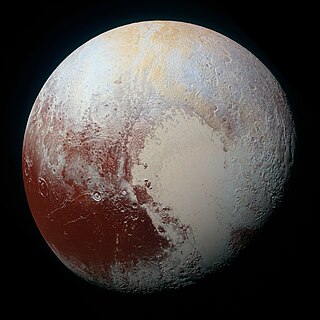
The geology of Pluto consists of the characteristics of the surface, crust, and interior of Pluto. Because of Pluto's distance from Earth, in-depth study from Earth is difficult. Many details about Pluto remained unknown until 14 July 2015, when New Horizons flew through the Pluto system and began transmitting data back to Earth. When it did, Pluto was found to have remarkable geologic diversity, with New Horizons team member Jeff Moore saying that it "is every bit as complex as that of Mars". The final New Horizons Pluto data transmission was received on 25 October 2016. In June 2020, astronomers reported evidence that Pluto may have had a subsurface ocean, and consequently may have been habitable, when it was first formed.
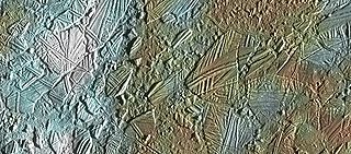
In astrogeology, chaos terrain, or chaotic terrain, is a planetary surface area where features such as ridges, cracks, and plains appear jumbled and enmeshed with one another. Chaos terrain is a notable feature of the planets Mars and Mercury, Jupiter's moon Europa, and the dwarf planet Pluto. In scientific nomenclature, "chaos" is used as a component of proper nouns.

The Noachis quadrangle is one of a series of 30 quadrangle maps of Mars used by the United States Geological Survey (USGS) Astrogeology Research Program. The Noachis quadrangle is also referred to as MC-27.

Tombaugh Regio, sometimes nicknamed "Pluto's heart" after its shape, is the largest bright surface feature of the dwarf planet Pluto. It lies just north of Pluto's equator, to the northeast of Belton Regio and to the northwest of Krun Macula, which are both dark features. Its western lobe, a 1,000 km (620 mi)-wide plain of nitrogen and other ices lying within a basin, is named Sputnik Planitia. The eastern lobe consists of high-albedo uplands thought to be coated by nitrogen transported through the atmosphere from Sputnik Planitia, and then deposited as ice. Some of this nitrogen ice then returns to Sputnik Planitia via glacial flow. The region is named after Clyde Tombaugh, the discoverer of Pluto.

Belton Regio is a prominent surface feature of the dwarf planet Pluto. It is an elongated dark region along Pluto's equator, 2,990 km (1,860 mi) long and one of the darkest features on its surface.

The geology of Charon encompasses the characteristics of the surface, crust, and interior of Pluto's moon Charon. Like the geology of Pluto, almost nothing was known of Charon's geology until the New Horizons of the Pluto system on 14 July 2015. Charon's diameter is 1,208 km (751 mi)—just over half that of Pluto. Charon is sufficiently massive to have collapsed into a spheroid under its own gravity.

The geography of Pluto is mainly focused the distribution of physical features across Pluto. On 14 July 2015, the New Horizons spacecraft became the first spacecraft to fly by Pluto. During its brief flyby, New Horizons made detailed geographical measurements and observations of Pluto and its moons.
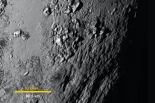
The Tenzing Montes are a range of icy mountains on Pluto, bordering the southwest region of Sputnik Planitia and the nearby Hillary Montes and Wright Mons. With peaks reaching 6.2 km in height, they are the highest mountain range on Pluto, and also the steepest, with a mean slope of 19.2 degrees.

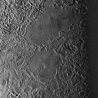
Sputnik Planitia is a large, partially glaciated basin on Pluto. About 1,400 by 1,200 km in size, Sputnik Planitia is partially submerged in large, bright glaciers of nitrogen ice. Named after Earth's first artificial satellite, Sputnik 1, it constitutes the western lobe of the heart-shaped Tombaugh Regio. Sputnik Planitia lies mostly in the northern hemisphere, but extends across the equator. Much of it has a surface of irregular polygons separated by troughs, interpreted as convection cells in the relatively soft nitrogen ice. The polygons average about 33 km (21 mi) across. In some cases troughs are populated by blocky mountains or hills, or contain darker material. There appear to be windstreaks on the surface with evidence of sublimation. The dark streaks are a few kilometers long and all aligned in the same direction. The planitia also contains pits apparently formed by sublimation. No craters were detectable by New Horizons, implying a surface less than 10 million years old. Modeling sublimation pit formation yields a surface age estimate of 180000+90000
−40000 years. Near the northwest margin is a field of transverse dunes, spaced about 0.4 to 1 km apart, that are thought to be composed of 200-300 μm diameter particles of methane ice derived from the nearby Al-Idrisi Montes.
Challenger Colles is a range of hills on Pluto near the eastern edge of Sputnik Planitia. Discovered by the New Horizons team in July 2015, It is named in honor of the Space Shuttle Challenger, which was destroyed with all seven crew lost on January 28, 1986. The name Challenger Colles was officially approved by the International Astronomical Union on May 27, 2022.

Vulcan Planitia, or Vulcan Planum, is the unofficial name given to a large plain on the southern hemisphere of Pluto's moon Charon. It discovered by New Horizons during its flyby of Pluto in July 2015. It is named after the fictional planet Vulcan in the science-fiction series Star Trek. The name is not approved by International Astronomical Union (IAU) as of 2024.

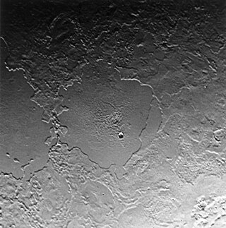
Wright Mons is a large, roughly circular mountain and likely cryovolcano on the dwarf planet Pluto. Discovered by the New Horizons spacecraft in 2015, it is located southwest of Sputnik Planitia within Hyecho Palus, adjacent to the Tenzing Montes and Belton Regio. A relatively young geological feature, Wright Mons has attracted attention as one of the most apparent examples of recent geological activity on Pluto and borders numerous other similarly young features. Numerous semi-regular hills surround and partially construct the flanks of Wright Mons. Their nature remains unexplained, with few, if any, direct analogs elsewhere in the Solar System.

The geology of Triton encompasses the physical characteristics of the surface, internal structure, and geological history of Neptune's largest moon Triton. With a mean density of 2.061 g/cm3, Triton is roughly 15-35% water ice by mass; Triton is a differentiated body, with an icy solid crust atop a probable subsurface ocean and a rocky core. As a result, Triton's surface geology is largely driven by the dynamics of water ice and other volatiles such as nitrogen and methane. Triton's geology is vigorous, and has been and continues to be influenced by its unusual history of capture, high internal heat, and its thin but significant atmosphere.
Tuonela Planitia is an elongated plain and probable cryolava lake on Neptune's moon Triton. Located in Triton's northern hemisphere within Monad Regio, it overlies part of Triton's unusual cantaloupe terrain. As with neighboring Ruach Planitia and other walled plains on Triton, Tuonela Planitia is among the youngest features on Triton's surface.
Ruach Planitia is a roughly circular flat plain and probable cryolava lake on Neptune's moon Triton. It is located in Triton's northern hemisphere within Monad Regio and directly borders the cryovolcanic plains of Cipango Planum. Ruach Planitia, along with the other walled plains on Triton, is one of the youngest and flattest features on Triton.


