Lynn Canal

Last updated
Lynn Canal, Haines area of southeast Alaska Lynn Canal-Haines Alaska.jpg
Lynn Canal, Haines area of southeast Alaska

Lynn Canal is an inlet (not an artificial canal) into the mainland of southeast Alaska.

Contents

Lynn Canal runs about 90 miles (140 km) from the inlets of the Chilkat River south to Chatham Strait and Stephens Passage. At over 2,000 feet (610 m) in depth, Lynn Canal is the deepest fjord in North America (outside Greenland) and one of the deepest and longest in the world.

The northern portion of the canal braids into the respective Chilkat, Chilkoot, and Taiya Inlets.

The Tlingit are the indigenous people of the Lynn Canal's shores and waterways. The inlet was explored for the Royal Navy by Joseph Whidbey in 1794 and named by George Vancouver for his birthplace, King's Lynn, Norfolk, England. [1]

Lynn Canal was frequently visited by maritime fur traders from at least 1800. The Atahualpa visited in 1801 and its log mentions an earlier trading visit by an unidentified ship. [2]

In April 1811 the American maritime fur trader Samuel Hill, captain of Otter , battled the Chilkat Tlingit in the Chilkat Inlet of Lynn Canal. Two of Hill's crew were killed, including his second mate and journal keeper Richard Kemp, his boatswain. Six more were wounded. According to Captain Hill, the Tlingit suffered 40 killed, including 13 chiefs. Hill blamed both his first mate and the Tlingit, but he was notoriously violent and frequently attacked indigenous people unprovoked. [3] [4] [5]

For several years after the 1811 battle fewer trade ships visited. By 1821 it was again a regular trading site, with visits by ships such as the Mentor in 1821. [3]

Transportation

Eldred Rock and avalanche chutes in Lynn Canal LynnCanal EldredRock.jpg
Eldred Rock and avalanche chutes in Lynn Canal

Lynn Canal's location as a penetrating waterway into the interior connects Skagway and Haines, Alaska, to Juneau and the rest of the Inside Passage thus making it a major route for shipping, cruise ships, and ferries.

During the Klondike Gold Rush it was a major route to the boom towns of Skagway and Dyea and thence to the Klondike gold fields. The worst maritime disaster in the history of the Pacific Northwest occurred in Lynn Canal during October 1918, when SS Princess Sophia, steaming southbound from Skagway, grounded on the Vanderbilt Reef and later sank, with the loss of all 343 passengers and crew.

After the gold rush and the creation of the White Pass and Yukon Route railroad, ore and other freight from the Yukon Territory was transported on the railroad to Skagway and its deepwater port and then shipped through Lynn Canal. However, in the 1970s and 1980s the freight subsided as mining activity curtailed in the interior and today very little freight is actually shipped in the Lynn Canal.

Currently, transportation in the canal is provided by Alaska Marine Highway ferries. There are also several other entrepreneurial water taxis and ferries available, but the AMHS is far and away the most frequently used. A project of uncertain future is the Lynn Canal Highway.

Because of Lynn Canal′s high use, the United States Coast Guard installed several lighthouses in the early 20th century including Eldred Rock Light, Sentinel Island Light, and Point Sherman Light.

Historically, Lynn Canal proved to be a waterway involved in the Alaska boundary dispute, over the strip of land running down the Pacific coast between British Columbia and Alaska. Of particular value was the fact that Lynn Canal provided access to the Yukon, where gold was found in 1896. The dispute was fought between the United Kingdom, which then controlled Canada's foreign relations, and the United States, and finally settled in 1903 by arbitration. The arbitrators ruled that the canal was part of Alaska, not British Columbia.

Related Research Articles

<span class="mw-page-title-main">Southeast Alaska</span> Region of Alaska

<span class="mw-page-title-main">Tlingit</span> Indigenous people of the Pacific Northwest Coast of North America

The Tlingit are indigenous peoples of the Pacific Northwest Coast of North America. Their language is the Tlingit language, in which the name means 'People of the Tides'. The Russian name Koloshi or the related German name Koulischen may be encountered referring to the people in older historical literature, such as Grigory Shelikhov's 1796 map of Russian America.

<span class="mw-page-title-main">Haines, Alaska</span> Census-designated place in Alaska, United States

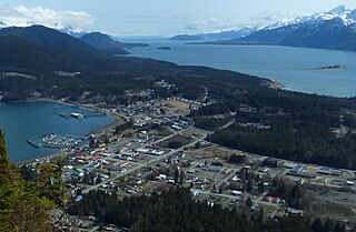
Haines is a census-designated place located in Haines Borough, Alaska, United States. It is in the northern part of the Alaska Panhandle, near Glacier Bay National Park and Preserve.

<span class="mw-page-title-main">Skagway, Alaska</span> Consolidated city-borough in Alaska, United States

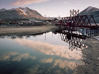
The Municipality and Borough of Skagway is a first-class borough in Alaska on the Alaska Panhandle. As of the 2020 census, the population was 1,240, up from 968 in 2010. The population doubles in the summer tourist season in order to deal with more than 1,000,000 visitors each year. Incorporated as a borough on June 25, 2007, it was previously a city in the Skagway-Yakutat-Angoon Census Area. The most populated community is the census-designated place of Skagway.

<span class="mw-page-title-main">Klondike Gold Rush</span> Migration by prospectors to the Klondike region of Yukon, Canada from 1896 to 1899

The Klondike Gold Rush was a migration by an estimated 100,000 prospectors to the Klondike region of Yukon, in north-western Canada, between 1896 and 1899. Gold was discovered there by local miners on August 16, 1896; when news reached Seattle and San Francisco the following year, it triggered a stampede of prospectors. Some became wealthy, but the majority went in vain. It has been immortalized in films, literature, and photographs.

<span class="mw-page-title-main">White Pass and Yukon Route</span> Canada–US railway line

The White Pass and Yukon Route is a Canadian and U.S. Class III 3 ft narrow-gauge railroad linking the port of Skagway, Alaska, with Whitehorse, the capital of Yukon. An isolated system, it has no direct connection to any other railroad. Equipment, freight and passengers are ferried by ship through the Port of Skagway, and via road through a few of the stops along its route.

<span class="mw-page-title-main">Chilkoot Trail</span> Long-distance hiking trail in Canada and the United States

The Chilkoot Trail is a 33-mile (53 km) trail through the Coast Mountains that leads from Dyea, Alaska, in the United States, to Bennett, British Columbia, in Canada. It was a major access route from the coast to Yukon goldfields in the late 1890s. The trail became obsolete in 1899 when a railway was built from Dyea's neighbor port Skagway along the parallel White Pass trail.

<span class="mw-page-title-main">White Pass</span>

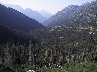
White Pass, also known as the Dead Horse Trail, is a mountain pass through the Boundary Ranges of the Coast Mountains on the border of the U.S. state of Alaska and the province of British Columbia, Canada. It leads from Skagway, Alaska, to the chain of lakes at the headwaters of the Yukon River, Crater Lake, Lake Lindeman, and Bennett Lake.

<span class="mw-page-title-main">Dyea, Alaska</span> Ghost town in Alaska, United States

Dyea is a former town in the U.S. state of Alaska. A few people live on individual small homesteads in the valley; however, it is largely abandoned. It is located at the convergence of the Taiya River and Taiya Inlet on the south side of the Chilkoot Pass within the limits of the Municipality of Skagway Borough, Alaska. During the Klondike Gold Rush prospectors disembarked at its port and used the Chilkoot Trail, a Tlingit trade route over the Coast Mountains, to begin their journey to the gold fields around Dawson City, Yukon, about 800 km (500 mi) away. Confidence man and crime boss Soapy Smith, famous for his underworld control of the neighboring town of Skagway in 1897–98 is believed to have had control of Dyea as well.

<span class="mw-page-title-main">Carcross</span> Place in Yukon, Canada

Carcross, originally known as Caribou Crossing, is an unincorporated community in Yukon, Canada, on Bennett Lake and Nares Lake. It is home to the Carcross/Tagish First Nation.

<span class="mw-page-title-main">Klondike Highway</span> Highway in Skagway, Alaska, United States and Yukon Territory, Canada

The Klondike Highway is a highway that runs from the Alaska Panhandle through the province of British Columbia and the territory of Yukon in Canada, linking the coastal town of Skagway, Alaska, to Dawson City, Yukon. Its route somewhat parallels the route used by prospectors in the 1898 Klondike Gold Rush.

<span class="mw-page-title-main">Dalton Trail</span>

The Dalton Trail is a trail that runs between Pyramid Harbor, west of Haines, Alaska in the United States, and Fort Selkirk, in the Yukon Territory of Canada, using the Chilkat Pass. It is 396 km (246 mi) long.

<span class="mw-page-title-main">Haines Highway</span> Highway in Alaska and Yukon Territory

The Haines Highway or Haines Cut-Off is a highway that connects Haines, Alaska, in the United States, with Haines Junction, Yukon, Canada, passing through the province of British Columbia. It follows the route of the old Dalton Trail from the port of Haines inland for about 180 km (110 mi) to Klukshu, Yukon, and then continues to Haines Junction. The highway is about 244 km (152 mi) long, of which 72 km (45 mi) is in Alaska.

<span class="mw-page-title-main">Chilkat Range</span>

The Chilkat Range is a mountain range in Haines Borough and the Hoonah-Angoon Census Area in the U.S. state of Alaska, west of the city of Juneau.

<span class="mw-page-title-main">Taiya River</span> River in Alaska, United States

The Taiya River is a 17-mile-long (27 km) river in the U.S. state of Alaska running from the border with British Columbia, Canada, to the Taiya Inlet of upper Lynn Canal.

<span class="mw-page-title-main">Taiya Inlet</span> Water body in Alaska, USA

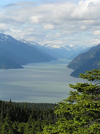
Taiya Inlet is part of the upper Lynn Canal located in the U.S. state of Alaska. Taiya Inlet is an estuary which lies in a deep valley, with Skagway, Alaska at its north end and the remainder of the Lynn Canal at its south end.

<span class="mw-page-title-main">Chilkat Inlet</span>

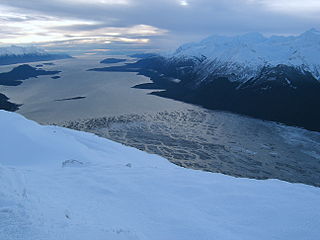
Chilkat Inlet is an inlet in Lynn Canal in the Southeast region of the U.S. state of Alaska that includes the delta for the Chilkat River and borders Haines and the Chilkat Peninsula. It was first charted in 1794 by Joseph Whidbey, master of HMS Discovery during George Vancouver's 1791–1795 expedition.

Chilkat or The Chilkat, or Chilkats, may refer to:

Samuel Hill was an American merchant sea captain and adventurer. He commanded various ships on many long voyages, often to remote parts of the world.

References

  1. U.S. Geological Survey Geographic Names Information System: Lynn Canal
  2. Malloy (1998), pp. 176–177
  3. 1 2 Malloy, Mary (1998). "Boston Men" on the Northwest Coast: The American Maritime Fur Trade 1788-1844. The Limestone Press. pp. 140–141. ISBN   978-1-895901-18-4.
  4. Malloy, Mary (2006). Devil on the deep blue sea: The notorious career of Captain Samuel Hill of Boston. Bullbrier Press. ISBN   978-0-9722854-1-4.
  5. Howay, Frederic William (1930). "The Attempt to Capture the Brig Otter". Washington Historical Quarterly. 21 (3): 179–188. JSTOR   40475341.

Alaska Fjordlines, Inc. is a wildlife day trip through the Lynn Canal. https://web.archive.org/web/20110203103152/http://www.alaskafjordlines.com/index.php

Cranny, Michael, and Garvin Moles. Counter Points: Exploring Canadian Issues. 2001. Toronto : Pearson Education Canada Inc, 2001. Print.

58°41′31″N135°05′51″W / 58.69194°N 135.09750°W / 58.69194; -135.09750