
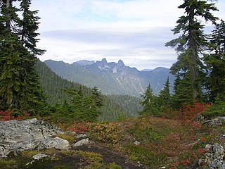
Mount Seymour is a mountain located in Mount Seymour Provincial Park in the District of North Vancouver, British Columbia, Canada. It is a part of the North Shore Mountains, rising to the north from the shores of Burrard Inlet and Indian Arm to a summit of 1,449 m (4,754 ft) above the Indian River and Deep Cove neighbourhoods. Mount Seymour is most commonly identified for its ski area of the same name, and as a popular hiking area. It is named in honour of Frederick Seymour, second governor of the Colony of British Columbia. The name is used to refer to the ridge although the main summit is one of several, and is also known as Third Peak.

The City of North Vancouver is a city on the north shore of Burrard Inlet, British Columbia, Canada. It is a suburb of Vancouver. It is the smallest in area and the most urbanized of the North Shore municipalities, although it has significant industry of its own – including shipping, chemical production, and film production. The city is served by the Royal Canadian Mounted Police, British Columbia Ambulance Service, and the North Vancouver City Fire Department.
Cypress Provincial Park is a provincial park on the North Shore of Metro Vancouver Regional District, British Columbia. The park has two sections: a 21 km2 (8.1 sq mi) southern section which is accessible by road from West Vancouver, and a 9 km2 (3.5 sq mi) northern section which is only accessible by hiking trails. The two sections are linked by a narrow strip of park along the mountainous Howe Sound Crest Trail.

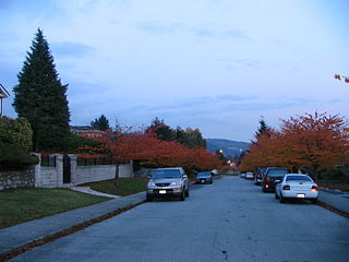
The District of North Vancouver is a district municipality in British Columbia, Canada, and is part of Metro Vancouver. It surrounds the City of North Vancouver on three sides. It is largely characterized as a relatively quiet, affluent suburban hub home to many middle and upper-middle-class families. Homes in the District of North Vancouver generally range from mid-sized family bungalows to very large luxury houses. A number of dense multi-family and mixed-use developments have popped up across the district in recent years; however, the district remains a primarily suburban municipality. It is served by the Royal Canadian Mounted Police, British Columbia Ambulance Service, and the District of North Vancouver Fire Department.

Siwash Rock is a rock outcropping in Vancouver, British Columbia, Canada's Stanley Park. A legend among the Indigenous Squamish people surrounds the rock. It is between 15 and 18 metres tall. It became known to mariners as Nine Pin Rock for its resemblance to a bowling pin.

The North Shore Mountains are a mountain range overlooking Vancouver in British Columbia, Canada. Their southernmost peaks are visible from most areas in Vancouver and form a distinctive backdrop for the city.

Lynn Canyon Park is a municipal park in the District of North Vancouver, British Columbia. When the park officially opened in 1912 it was only 12 acres (4.9 ha) in size, but it now encompasses 617 acres (250 ha). The park has many hiking trails of varying length and difficulty. The Baden-Powell Trail passes through the park crossing over the Lynn Canyon Suspension Bridge. Due to its natural landscape many TV series such as Stargate SG-1 and Stargate Atlantis used the area for filming.
The Baden-Powell Trail is a rugged but well-maintained 48 km hiking trail, that traverses from Horseshoe Bay in West Vancouver to Deep Cove in North Vancouver, British Columbia, Canada. It was named after Robert Baden-Powell, Lord Baden-Powell, founder of the world Scouting Movement.
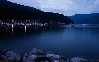
Deep Cove refers to the community in the easternmost part of the District of North Vancouver, in British Columbia, Canada, and is also the geographic name of the small bay beside the town. It is affectionately referred to as "The Cove" by local residents. Located at the foot of Mount Seymour, Deep Cove faces due east, fronting onto Indian Arm, a branch of the Burrard Inlet. The area is the traditional territory of the Tsleil-Waututh and Squamish Nations. Deep Cove is 13 kilometres (8.1 mi) from downtown Vancouver.
ȽÁU,WELṈEW̱/John Dean Provincial Park, formerly John Dean Provincial Park, is a small, densely vegetated provincial park on the Saanich Peninsula of southern Vancouver Island, British Columbia, Canada. The park is located on and around ȽÁU,WELṈEW̱, a small mountain in the traditional territory of Wsanec First Nations, itself situated 20 km north of Victoria, the provincial capital city.

Mount Fromme is one of the North Shore Mountains that overlook Burrard Inlet north of Vancouver, British Columbia. It stands just east of Grouse Mountain, and the District of North Vancouver and the City of North Vancouver lie on its lower slope where it descends to the inlet. Mount Fromme, like the other mountains of the Pacific Ranges, is covered with temperate rainforest of the Coastal Western Hemlock Zone. In the case of Mount Fromme this is largely secondary forest, since the mountain was extensively logged in the early 20th century. Outside of the Vancouver area Mount Fromme is known as a mountain biking destination.
Edgemont Village is a neighbourhood within the District of North Vancouver, in British Columbia, Canada. It is situated between several converging suburbs, centering on the intersection of Edgemont Boulevard and Highland Boulevard, where it is a minor residential and commercial center for local communities. According to the District of North Vancouver's Official Community Plan, Edgemont Village encompasses the shops and tenements along and immediately surrounding Edgemont Boulevard between West Queens Road and Ridgewood Drive. However, it is broadly recognized as taking up much of the hillside plateau between the Mackay and Mosquito creeks, bordering Ridgewood Drive to the north and the Upper Levels Highway to the south.
Parkcrest is a hillside neighbourhood in North Burnaby, British Columbia adjacent to Kensington Park which gave it its name. It has a long rectangular shape stretched north to south and is bounded by Springer Avenue to the west and Kensington Avenue to the east. To the north its border runs along Hastings Street, its southern border lies along the Lougheed Highway and Skytrain tracks. Its elevation gradually lowers to the south and ends up in Central Valley, quite low above the level of Burnaby Lake.

Lighthouse Park is a neighbourhood park located in a residential area in West Vancouver, Canada. It is a popular tourist attraction for visitors to Vancouver as it is a National Historic Site of Canada. It is a well-maintained park, and is open year-round throughout all four seasons. The park is known for the Point Atkinson Lighthouse, located at the southernmost tip of the peninsula. The park is made up of 75 hectares of mostly virgin rainforest, and was founded in 1792. The District of West Vancouver maintains and operates the park and permits visitors from 7:00 a.m. to 10:00 p.m. Visitors to this park can enjoy the various beginner level hiking trails, as well as bring their dogs for a walk or have lunch along the rocks of the beach near the Lighthouse. There are various picnic benches scattered throughout the trails of the park, yet none near the beach and the lighthouse itself.

Buntzen Lake is a 4.8 kilometres (3 mi) long lake in Anmore, British Columbia, Canada, in the Greater Vancouver area. It is named after the first general manager of the B.C. Electric Co., Johannes Buntzen. There is a smaller lake just to the north named McCombe Lake.
Lynn Valley Elementary School is a public school in Lynn Valley section of the District of North Vancouver, British Columbia, Canada. The school, part of School District 44 North Vancouver, serves children in kindergarten through seventh grade.
Lynn Headwaters Regional Park is an area of North Vancouver, British Columbia, and is the largest of twenty-two regional parks in Metro Vancouver. At 9,216.5 acres (3,729.8 ha), the park boasts a variety of trails for hikers, including easy, intermediate, and challenging. The trails are colour-coded and range from 3 kilometres (1.9 mi) to 21.4 kilometres (13.3 mi). Bikes and dogs are allowed on select trails.

Mount Seymour Provincial Park is a park in Vancouver, British Columbia's North Shore Mountains. With an area of 35 square kilometres, it is located approximately 15 kilometres north of Downtown Vancouver. The park, named after Frederick Seymour, was established in 1936. Mount Seymour Provincial Park provides visitors with a variety of recreational activities and animals with natural habitat.
The Lynn Valley Tree was one of the tallest known Coast Douglas-fir, at a measured height of 126.5 meters (415 ft). It was cut down by the Tremblay Brothers, at Argyle Road in 1902 on the property of Alfred John Nye in Lynn Valley, now part of metropolitan Vancouver, B.C. It measured 4.34 meters (14.2 ft) across the butt, and the bark was 13.5 inches in thickness. Since that time, in the lower valley where the tree grew, the entire old-growth forest has been logged, including another tree felled in the same valley that was said to have measured 107 m tall.
Capilano is a neighbourhood in the District of North Vancouver, Canada. It is primarily composed of low density single family residential (RS), but contains a small amount of low density multi-family residential (RM) along arterial roads.
