Machars

Last updated

The Machars
Machair Ghallghaidhealaibh (Scottish Gaelic)
West Coast of the Machars - geograph.org.uk - 3085411.jpg
Luce Bay coastline of The Machars, south of Auchenmalg
Location Wigtownshire, Dumfries & Galloway
Native nameMachair Ghallghaidhealaibh (Scottish Gaelic)
Highest elevation
(Mochrum Fell)
197m

The Machars (Scottish Gaelic : Machair Ghallghaidhealaibh) is a peninsula in the historical county of Wigtownshire in Galloway in the south-west of Scotland. Its name (in Scots [1] and English) is derived from the Gaelic word Machair meaning low-lying or level land, known as "links" on the east coast of Scotland. Although there are no high peaks in The Machars, it is not flat and would best be described as undulating or rolling. The North Atlantic Drift or Gulf Stream creates a mild climate, and dolphins and basking sharks are frequently seen in the seas.

Contents

Geography

The Machars peninsula is roughly defined by a northern boundary stretching from Newton Stewart to Glenluce, the only other boundary being the sea. The 40-mile (64 km) coastline has enormous variety, starting with the mud-flats of Wigtown on the east facing Wigtown Bay, down to the sandy beach at Rigg Bay in Garlieston (where the Mulberry Harbours were developed). The coastline then rises to form dramatic cliffs as it passes the ruins of Cruggleton Castle, dropping a little at Portyerrock Bay and the Isle of Whithorn, and rising again at Burrow Head (where the climax of classic cult film The Wicker Man was filmed).

Past the southern tip of the peninsula, the shoreline leaves Wigtown Bay and becomes part of Luce Bay. The cliffs continue as far as the beautiful sandy beach at Monreith ( childhood home of the author Gavin Maxwell), and on past Port William. A combination of rocky shoreline, sandy beaches and cliffs continues as far as Auchenmalg and Stairhaven before the sandy dunes approaching Glenluce. Two rivers cut through the peninsula, the River Bladnoch which rises at Loch Maberry and meets the sea just south of Wigtown, and one of its major tributaries the Tarf Water which meets the Bladnoch near Kirkcowan. Another tributary of the Bladnoch is the large stream the Water of Malzie which rises in the large expanses of peat bog near the Old Place of Mochrum before meeting the Bladnoch near Cormalzie.

Generally speaking the Eastern half of the Machars can be described as being a landscape of rolling green hills and scattered woodland which forms a perfect setting for the large scale dairy industry which can be found here. In fact up until recent decades a large scale creamery was to be found at Sorbie although this has now closed. This landscape extends to the far southern extremities of the peninsula, however the landscape to the North West is significantly different, where above the raised beaches of Luce Bay a rugged expanse of moorland and bog can be found, more reminiscent of the rough country to the north. The highest point of the Machars can be found here, Mochrum Fell, however for the most part the terrain can be characterised as a series of low, stony ridges interspersed by large expanses of peat bog and moorland and many small lochs. This part of the Machars is generally associated with large scale forestry plantations, especially of Sitka Spruce, and stock-rearing, either the hardy Belted Galloway or more typically Galloway cattle or sheep.

The other principal settlements on the peninsula are: Kirkcowan, Whithorn, Isle of Whithorn, Kirkinner, Sorbie, Mochrum, Elrig, Bladnoch and Whauphill.

There are a number of large lochs in the area including Mochrum Loch, Castle Loch and the White Loch of Myrton.

History

The area is rich in prehistoric remains, mainly in the form of standing stones and cup and ring marks. The most notable of these are Torhousekie stone circle and Drumtroddan standing stones. In Castle Loch near The Old Place of Mochrum are the remains of several crannogs.

Burrow Head (the southernmost tip of the peninsula) is about 18 miles (29 kilometres) from Point of Ayre on the Isle of Man, and trade links have long existed between the two places, much of which involved smuggling.

The primary industry in the area was agriculture, though today the tourist industry probably employs more people and generates more income.

Saint Ninian

Saint Ninian first brought Christianity to what-would-become Scotland via the Machars, founding a small church at the Isle of Whithorn from which a mediæval cathedral later sprang at Whithorn. Ninian studied under St Martin of Tours and can lay claim to bringing Christianity to Scotland long before St Columba, whose church at Iona is often mistakenly credited as the cradle of Scottish Christianity.

RAF Wigtown

The Machars is also home to the former RAF Wigtown. The airfield, which was opened in 1941 and is often referred to as Baldoon, was used in World War II as a training school - hosting the No 1 Air Observers School from September 13, 1941, to February 1, 1942, and operating in conjunction with a tracked target range near the coast to the southeast. Although the site originally consisted of grass runways, flooding of the land soon caused these to become unusable, and two concrete runways were installed during 1942. Operations at the airfield ceased in 1945, to coincide with the end of the war, and control of the site was given over to Maintenance Command which was placed in care and maintenance, transferring to No 14 Maintenance Unit from July 1, 1946, to March 1, 1948, when the airfield was finally closed. [2]

Despite considerable deterioration much of the airfield remains intact; with the original control tower still standing and nearly all the perimeter and access roads remaining. Furthermore, the concrete bases of many of the hangars and other buildings can still be seen on the ground. Today much of the land has reverted to agricultural use, with the site becoming popular for locals to conduct leisure activities – such as walking or cycling.

Related Research Articles

<span class="mw-page-title-main">Dumfries and Galloway</span> Council area of Scotland

Dumfries and Galloway is one of 32 unitary council areas of Scotland and is located in the western Southern Uplands. It covers the historic counties of Dumfriesshire, Kirkcudbrightshire, and Wigtownshire, the latter two of which are collectively known as Galloway. The administrative centre and largest settlement is the town of Dumfries. The second largest town is Stranraer, on the North Channel coast, some 57 miles (92 km) to the west of Dumfries.

<span class="mw-page-title-main">Wigtown</span> Human settlement in Scotland

Wigtown is a town and former royal burgh in Wigtownshire, of which it is the county town, within the Dumfries and Galloway region in Scotland. It lies east of Stranraer and south of Newton Stewart. It is known as "Scotland's National Book Town" with a high concentration of second-hand book shops and an annual book festival.

<span class="mw-page-title-main">Isle of Whithorn</span> Human settlement in Scotland

Isle of Whithorn is one of the most southerly villages and seaports in Scotland, lying on the coast north east of Burrow Head, about three miles from Whithorn and about thirteen miles south of Wigtown in Dumfries and Galloway. Whithorn,, is a former royal burgh in Wigtownshire, Dumfries and Galloway, with which Isle of Whithorn is frequently incorrectly amalgamated or confused. It is referred to locally as 'The Isle' - never 'the Isle of Whithorn'.

<span class="mw-page-title-main">Wigtownshire</span> Historic county in Scotland

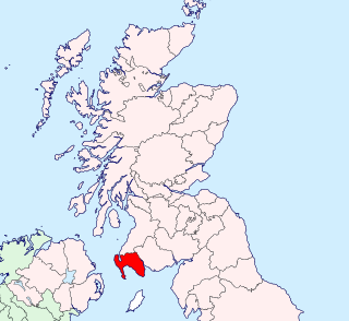
Wigtownshire or the County of Wigtown is one of the historic counties of Scotland, covering an area in the south-west of the country. Until 1975, Wigtownshire was an administrative county used for local government. Since 1975 the area has formed part of Dumfries and Galloway for local government purposes. Wigtownshire continues to be used as a territory for land registration, being a registration county. The historic county is all within the slightly larger Wigtown Area, which is one of the lieutenancy areas of Scotland and was used in local government as the Wigtown District from 1975 to 1996.

<span class="mw-page-title-main">Port William, Dumfries and Galloway</span> Human settlement in Scotland

Port William is a fishing village in the parish of Mochrum in the historical county of Wigtownshire, Dumfries and Galloway, in Scotland with a population of approximately 460.

<span class="mw-page-title-main">River Bladnoch</span>

The Bladnoch is a river in Wigtownshire in the Machars of Galloway in southwest Scotland. One of the earliest descriptions of it is given by Sir Andrew Agnew of Lochnaw and Sir David Dunbar in an appendix to Andrew Symson's work "A Large Description of Galloway" written in the 17th century. In this they state that:

Blaidzenoch which floweth from the mountnous parts of Penninghame, and runs from the north to the south. It runneth through Lochmabary, and by the way it receaveth into several waters; the most considerable is the water of Tarfe, which hath its rise from Airtfeeld, in the Muirs of Luce, and falleth into Blaidzenoch, under the house of Craighlaw. The Blaidzenoch turns to the east, and after it heth fra its source run twenty miles (32 km), it falleth into the Bay of Wigtown, near above the place of Baldone.

<span class="mw-page-title-main">Diocese of Galloway</span>

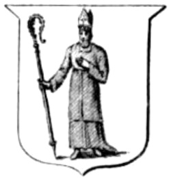
The Diocese of Galloway was one of the thirteen dioceses of the pre-1689 Scottish Church. The Diocese was led by the Bishop of Galloway and was centred on Whithorn Cathedral.

Sorbie is a small village in Wigtownshire, Machars, within the Administration area of Dumfries and Galloway Council, Scotland.

Mochrum is a coastal civil and Church of Scotland parish situated to the east of Luce Bay on the Machars peninsula and 8 miles (13 km) southwest of Wigtown and in the historical county of Wigtownshire in Galloway, Scotland. It covers 22,000 acres (8,900 ha) and is approximately 10 miles (16 km) in length and 5 miles (8.0 km) in breadth. The parish contains the eponymous village of Mochrum, as well as Port William and the clachan of Elrig.

Glasserton is a civil parish in Dumfries and Galloway, south-west Scotland. It is on the Machars peninsula, in the traditional county of Wigtownshire. The parish is about 8 miles (13 km) in length, varying in breadth from 1 to 3 miles, and contains 13,477 acres (54.54 km2).

Kirkcowan is an area about 15 miles in length, and from nearly two to nearly seven miles in breadth, comprising 30,580 acres, of which 7000 are arable, 300 woodland and plantations, and the remainder meadow, pasture in Machars, in the historical county of Wigtownshire, in Dumfries and Galloway, Scotland, with the village of Kirkcowan, bounded on the east by the river Bladnoch, on the west by the river Tarff, and is 6 miles W. by S.W. from Newton Stewart.

<span class="mw-page-title-main">Cruggleton Castle</span> Castle in Scotland

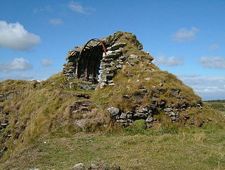
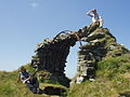
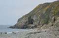
Cruggleton Castle is a multi-period archaeological site on the coast of the Machars, in the historical county of Wigtownshire in south-west Scotland. It is located at Cruggleton Point, around 4.5 kilometres (2.8 mi) east of Whithorn and 6 kilometres (3.7 mi) south-east of Sorbie. Excavations in the 1970s and 1980s revealed several periods of use, from the 1st century AD to the 17th century. The first stone tower was built in the 13th century, on an earlier motte.

<span class="mw-page-title-main">River Cree</span>

The River Cree is a river in Dumfries and Galloway, Scotland which runs through Newton Stewart and into the Solway Firth. It forms part of the boundary between the counties of Wigtownshire and Kirkcudbrightshire. The tributaries of the Cree are the Minnoch, Trool, Penkiln and Palnure which drain from the Range of the Awful Hand, the labyrinthine range of mountains and lochs, bogs, burns and crags, rising at its highest to The Merrick, Galloway, 12 miles north and visible from Newton Stewart.

<span class="mw-page-title-main">Doon of May</span>

The Doon of May is a conifer plantation associated with an Iron Age hill fort in Dumfries and Galloway, south-west Scotland. Located around 14 kilometres (8.7 mi) west of Wigtown on the Machars peninsula, it is in the parish of Mochrum in the traditional county of Wigtownshire. The plantation was purchased from the Forestry Commission by the Tinne Beag Workers’ Co-operative in 1999 and since then the co-operative has been managing the woodland for sustainable use of both timber and non-timber forest products, while increasing biodiversity and restoring native vegetation types where possible.

<span class="mw-page-title-main">Wigtown Bay</span>

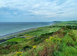
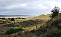
Wigtown Bay is a large inlet of the Irish Sea on the coast of Galloway in southwest Scotland. Its coastline falls entirely within the modern administrative area of Dumfries and Galloway and shared between the historical counties of Wigtownshire and Kirkcudbrightshire.

Penninghame in Wigtownshire, Dumfries and Galloway, Scotland, is a civil parish area, 8 miles from Wigtown. The area is approx 16 miles in length, and from 5 to 6 miles' width, bounded on the north and east by the River Cree, and on the west by the Bladnoch; comprising nearly 38,000 acres, of which 12,000 were arable, 600 woodland and plantations, 1600 meadow, and the remainder hill pasture, moorland, moss, etc.

Old Luce is a civil parish in Dumfries and Galloway, Scotland. It lies in the Machars peninsula, in the traditional county of Wigtownshire. The parish is around 10 miles (16 km) long and 8 miles (13 km) broad, and contains 40,350 acres (16,330 ha).

References

  1. "SND: machair". Dictionaries of the Scots Language. Dictionaries of the Scots Language. Retrieved 16 February 2022.
  2. "Secret Scotland - RAF Wigtown". www.secretscotland.org.uk.
54°49′N4°38′W / 54.82°N 4.64°W / 54.82; -4.64