Madurai district

Last updated

Madurai district
Madurei 350.jpg
Thirumalai Nayakkar Mahal in Madurai.jpg
YanamalaiJainsculptures (7).jpg
Kallazhagar (29).jpg
Kutladampatti Falls 2.jpg
Madurai in Tamil Nadu (India).svg
Location in Tamil Nadu
Madurai district
Madurai district
Coordinates: 09°50′N077°50′E / 9.833°N 77.833°E / 9.833; 77.833 [1]
Country Flag of India.svg  India
State TamilNadu Logo.svg Tamil Nadu
Municipal Corporations Madurai
Headquarters Madurai
Taluks Madurai North, Madurai South, Madurai East, Madurai West, Melur, Peraiyur, Tirumangalam, Thiruparankundram, Usilampatti, Vadipatti, Kalligudi
Government
  TypeDistrict Administration
  BodyMadurai District Collectorate
   District Collector Aneesh Sekhar, I.A.S.
   Superintendent of Police Sujit Kumar, I.P.S.
Area
  Total3,710 km2 (1,430 sq mi)
  Rank16
Population
 (2011)
  Total3,038,252
  Rank4
  Density812/km2 (2,100/sq mi)
Languages
  Official Tamil and English
Time zone UTC+5:30 (IST)
PIN
625xxx
Telephone code0452
Vehicle registration TN-58, TN-59, TN-64 [2]
Coastline0 kilometres (0 mi)
Largest city Madurai
Sex ratio -50.5% / -49.5%
Literacy81.5%
Lok Sabha constituency1
Assembly constituency 10
Website www.madurai.tn.nic.in

Madurai district is one of the 38 districts of the state of Tamil Nadu in southeastern India. [1] [3] The city of Madurai serves as the district headquarters. It houses the famous Sri Meenakshi Sundareshwarar temple and is situated on the banks of the river Vaigai. Thiruparankundram is one of the major tourist place in the district. As of 2011, the district had a population of 3,038,252 with a sex-ratio of 990 females for every 1,000 males. Aside from the city of Madurai, the larger towns are Melur, Vadipatti, Thirumangalam, Thirupparankundram, Peraiyur, and Usilampatti. [4] It is an important hub for various film shootings. Alanganallur is a popular spot in the district for Jallikattu, as are Palamedu and Avaniyapuram.

Contents

History

The famous Jallikattu at Alanganallur Bull Taming, Alanganallur, India.jpg
The famous Jallikattu at Alanganallur

Madurai is called by various nicknames like Athens of the East, Thoonga Nagaram (City that never Sleeps), Naan maada koodal (City of Four junctions), Malligai Managar (City of Jasmine), Koodal Managar (City of Junction) Koil Nagar (Temple city), etc. The main kingdoms which ruled Madurai during various times are the Pandyas and the Nayaks. [5]

Geography

The district is bounded by Theni in the west, Sivaganga in the east, Dindigul in the north, Virudhunagar in the south and small parts of Tiruchirappalli in the northeast. Madurai district witnessing hot and humid weather throughout the year and considered as hottest district of Tamil Nadu as well hottest city.

Climate

Madurai
Climate chart (explanation)
J
F
M
A
M
J
J
A
S
O
N
D
 
 
20
 
 
30
20
 
 
14
 
 
32
21
 
 
18
 
 
35
23
 
 
55
 
 
38
25
 
 
70
 
 
37
26
 
 
40
 
 
36
26
 
 
50
 
 
36
25
 
 
104
 
 
35
25
 
 
119
 
 
34
24
 
 
188
 
 
33
24
 
 
145
 
 
30
23
 
 
51
 
 
29
21
Average max. and min. temperatures in °C
Precipitation totals in mm
Imperial conversion
JFMAMJJASOND
 
 
0.8
 
 
86
68
 
 
0.5
 
 
90
70
 
 
0.7
 
 
95
73
 
 
2.2
 
 
100
77
 
 
2.8
 
 
99
79
 
 
1.6
 
 
97
79
 
 
1.9
 
 
96
77
 
 
4.1
 
 
95
77
 
 
4.7
 
 
93
75
 
 
7.4
 
 
91
75
 
 
5.7
 
 
86
73
 
 
2
 
 
84
70
Average max. and min. temperatures in °F
Precipitation totals in inches

The climate has extremes. There are three distinct periods of rainfall:

Demographics

Historical population
YearPop.±% p.a.
1901666,940    
1911769,360+1.44%
1921800,795+0.40%
1931896,876+1.14%
19411,014,602+1.24%
19511,223,574+1.89%
19611,378,734+1.20%
19711,730,109+2.30%
19812,042,704+1.67%
19912,400,339+1.63%
20012,578,201+0.72%
20113,038,252+1.66%
source: [6]
Religions in Madurai district (2011) [7]
ReligionPercent
Hinduism
90.86%
Islam
5.56%
Christianity
3.22%
Other or not stated
0.36%

According to 2011 census, Madurai district had a population of 3,038,252, [8] up from 2,578,201 in the 2001 census, [4] for a growth rate of 17.95%. It had a sex-ratio of 990 females for every 1,000 males, up from 978 in 2001, [4] and much above the national average of 929. [8] A total of 313,978 were under the age of six, constituting 162,517 males and 151,461 females. Scheduled Castes and Scheduled Tribes accounted for 13.46% and 0.37% of the population, respectively. The average literacy of the district was 74.83%, compared to the national average of 72.99%. 60.78% of the population lives in urban areas. [8]

The district had a total of 794,887 households. There were a total of 1,354,632 workers, comprising 81,352 cultivators, 287,731 main agricultural labourers, 39,753 in house hold industries, 765,066 other workers, 180,730 marginal workers, 11,367 marginal cultivators, 85,097 marginal agricultural labourers, 7,540 marginal workers in household industries and 76,726 other marginal workers. [8]

Languages of Madurai district (2011) [9]

   Tamil (92.56%)
   Saurashtra (3.20%)
   Telugu (2.58%)
  Others (1.66%)

At the time of the 2011 census, 92.56% of the population spoke Tamil, 3.20% Saurashtra and 2.58% Telugu as their first language. [9]

Politics

DistrictNo.ConstituencyNamePartyAllianceRemarks
Madurai 188 Melur Periyapullan @ P. Selvam All India Anna Dravida Munnetra Kazhagam AIADMK
189 Madurai East P. Moorthy Dravida Munnetra Kazhagam INDIA
190 Sholavandan (SC) A. Venkatesan Dravida Munnetra Kazhagam INDIA
191 Madurai North G. Thalapathi Dravida Munnetra Kazhagam INDIA
192 Madurai South M. Boominathan Dravida Munnetra Kazhagam (MDMK) INDIA
193 Madurai Central Palanivel Thiagarajan Dravida Munnetra Kazhagam INDIA
194 Madurai West Sellur K. Raju All India Anna Dravida Munnetra Kazhagam AIADMK
195 Thiruparankundram V. V. Rajan Chellappa All India Anna Dravida Munnetra Kazhagam AIADMK
196 Tirumangalam R. B. Udhayakumar All India Anna Dravida Munnetra Kazhagam AIADMK Deputy Leader of the Opposition
197 Usilampatti P. Ayyappan Independent Independent

Madurai district contains the entirety of Madurai Lok Sabha constituency, and parts of Theni and Virudhunagar Lok Sabha constituencies.

Divisions

Madurai district comprises 13 talukas and revenue blocks, same names same boundaries. Under the gram panchayat system rural administration or the district is done by panchayat villages and the taluka headquarters. The revenue blocks are further sub-divided by firkas. The three taluks, Tiruparankundram, Madurai West and Madurai East, were created in February 2014. [10] The thirteen talukas/blocks are: [11] [12] [13]

2001 census

Village house in Melur Madurai Melur.jpg
Village house in Melur

In the 2001 census, Madurai district had only seven talukas: Madurai North, Madurai South, Melur, Peraiyur, Thirumangalam, Vadipatti, and Usilampatti. [14]

Tourist attractions

Localities

See also

Related Research Articles

<span class="mw-page-title-main">Madurai</span> City in Tamil Nadu, India

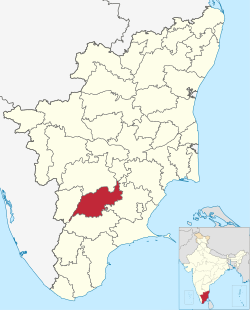
Madurai is a major city in the Indian state of Tamil Nadu. It is the cultural capital of Tamil Nadu and the administrative headquarters of Madurai District. As of the 2011 census, it was the third largest urban agglomeration in Tamil Nadu after Chennai and Coimbatore and the 33rd most populated city in India. Located on the banks of River Vaigai, Madurai has been a major settlement for two millennia and has a documented history of more than 2500 years. It is often referred to as "Thoonga Nagaram", meaning "the city that never sleeps".

<span class="mw-page-title-main">Melur</span> Municipality in Tamil Nadu, India

Melur is the Northern entrance of Madurai district. It is the town and municipality in the Madurai North in the Indian state of Tamil Nadu. Melur Old Name is Called Naduvi Nadu. The name Melur name comes from "Mela Nadu". Melur is called Thaigramam. It is the biggest taluk within the Madurai District. As of 2011, the town had a population of 40,017. Melur is an agricultural land in Madurai and the climate around the area is tropical.

<span class="mw-page-title-main">Tiruchirappalli district</span> District of Tamil Nadu in India

Tiruchirappalli District is one of the 38 districts, located along the Kaveri River, in Tamil Nadu, India. The headquarters of the district is the city of Tiruchirappalli.

<span class="mw-page-title-main">Dindigul district</span> District of Tamil Nadu in India

Dindigul District is one of the 38 districts in the state of Tamil Nadu in India. Dindigul District is the second largest district in Tamil Nadu by area after Thiruvannamalai District. The district was carved out of Madurai District in 1985. It has an area of 6266.64 km2 and comprises 3 revenue divisions, 10 taluks, and 14 panchayat unions. The district is bound by Tiruppur district in the northwest, Karur district in the north, Tiruchirappalli district in the northeast, Madurai and Theni districts in the south, and Idukki district of Kerala to the west. As of 2011, the district had a population of 2,159,775 with a sex-ratio of 998 females for every 1,000 males.

<span class="mw-page-title-main">Theni district</span> District of Tamil Nadu in India

Theni District is one of the 38 districts of Tamil Nadu state in India. Well protected by the scenic hill locks, the district is located besides Madurai district. The town of Theni is the district headquarters. The district is divided into two natural divisions: The hilly areas are constituted by parts of the five taluk's Theni, Bodinayakanur, Periyakulam, Uthamapalayam and Andipatti with thick vegetation and perennial streams from the hills on the western side and Cumbum valley which lies in Uthamapalayam taluk. As of 2011, Theni district had a population of 1,245,899 with a sex ratio of 980 females for every 1,000 males.

<span class="mw-page-title-main">Avaniapuram</span> Village in Tamil Nadu, India

Avaniapuram is a neighbourhood in Madurai in the state of Tamil Nadu, India. As of 2011, the municipality had a population of 89,635. It was annexed with the Madurai Municipal Corporation in 2011. The locality is famous for Jallikattu which happens on Pongal day.

Cumbum, natively spelt as Kambam, is a town and municipality in Theni district, an Indian state of Tamil Nadu.

Sholavandan is a panchayat town in Madurai district in the Indian state of Tamil Nadu. It is located on the left bank of the Vaigai River, sixteen miles north west of Madurai. It is one of 12 "town- panchayats" of Madurai district.

T. Kallupatti is a panchayat town in the Madurai district in the Indian state of Tamil Nadu.

Thirunagar is a neighborhood within the Madurai district in the Indian state of Tamil Nadu.

<span class="mw-page-title-main">Thiruparankundram</span> Place in Tamil Nadu, India

Thiruparankundram, also spelled Tirupparankundram or Tiruparangundram, is a neighbourhood in Madurai city in Tamil Nadu, India. It is about 7 kilometres (4.3 mi) from Periyar Bus Terminus, the centre of the city and constitutes the southwest part of the Madurai city. The town's landmark and fame is the huge monolithic rock hill that towers to a height of 1,048 feet (319 m) and has a circumference of over 2 miles (3.2 km). It is a home to many ancient and historic monuments including Jain caves, some protected as India's national monuments.

<span class="mw-page-title-main">Usilampatti</span> Town in Tamil Nadu, India

Usilampatti is a town and a second grade municipality in the Indian state of Tamil Nadu. It is also a designated taluk and revenue division.

T. Vadipatti is a panchayat town in the Madurai district in the Indian state of Tamil Nadu.and also known as "west gateway of Madurai.

<span class="mw-page-title-main">Tirumangalam, Madurai</span> Town in Tamil Nadu, India

Tirumangalam is a town and municipality in the Madurai District of the Indian state of Tamil Nadu also called as 'Thoongaa Nagarathin Thunai Nagaram' ..

Gudalur is a municipal town in Theni district in the Indian state of Tamil Nadu. As of 2011, its population was 41,915.

<span class="mw-page-title-main">Sengottai</span> Town in Tamil Nadu, India

Sengottai is a town in the Tenkasi district, of Tamil Nadu, India. It is the gateway to southern Tamil Nadu and Kerala. Spread over an area of 2.68 km2 with a population of over 26,823, the economy of the town and Sengottai Taluk revolves around the cultivation of rice,coconut,Mango,clove and pepper. Sengottai is well known in Tamil Nadu as a major market of Dosa kal. This town has lot of Black smith shops.

Mullipallam is a panchayat village in Vadipatti Taluka of Madurai district, Tamil Nadu, India, with a total of 2173 families residing.

Alanganallur revenue block in the Madurai district of Tamil Nadu, India. It has a total of 37 panchayat villages. It has the same name and boundaries as the revenue block.

Venkatachalapuram is a small village situated in Theni District, Tamil Nadu, India and with direct road connectivity to Theni and Odaipatti. The district headquarters, Theni, is situated 11 kilometres (6.8 mi) north of this village.

The Madurai Metropolitan Area, is the 31st largest metropolitan area in India and is the fourth largest metropolitan area in the state of Tamil Nadu only next to Chennai, Coimbatore and Salem. The Madurai Metropolitan Area consists of the city of Madurai and its suburbs in Madurai district.

References

  1. 1 2 Madurai (Approved) at GEOnet Names Server, United States National Geospatial-Intelligence Agency
  2. "Registration Series Allotted to Regional Transport Offices" (PDF). Government of Tamil Nadu, State Transport Authority. Archived (PDF) from the original on 12 September 2012.
  3. "Madurai District, Government of Tamilnadu | Athens of the East | India" . Retrieved 15 January 2021.
  4. 1 2 3 "Census of India 2001: Basic data Sheet: Madurai District, Tamil Nadu" (PDF). The Registrar General and Census Commissioner.
  5. "Madurai". britannica.com.
  6. Decadal Variation In Population Since 1901
  7. "Table C-01 Population by Religion: Tamil Nadu". censusindia.gov.in. Registrar General and Census Commissioner of India. 2011.
  8. 1 2 3 4 "District Census Handbook 2011 - Madurai" (PDF). Census of India . Registrar General and Census Commissioner of India.
  9. 1 2 "Table C-16 Population by Mother Tongue: Tamil Nadu". Census of India . Registrar General and Census Commissioner of India.
  10. Mariappan, Julie (12 February 2014). "23 new taluks created in Tamil Nadu". The Times of India . Archived from the original on 19 April 2014.
  11. "Map: Madurai District Blocks". Madurai District. Archived from the original on 9 July 2018. Retrieved 22 November 2010.
  12. "Reports of National Panchayat Directory: Village Panchayat Names of Madurai, Tamil Nadu". Ministry of Panchayati Raj, Government of India. Archived from the original on 13 November 2011.
  13. "Revenue Administration | Madurai District, Government of Tamilnadu | India" . Retrieved 29 November 2020.
  14. "2001 Census of India: List of Villages by Tehsil: Tamil Nadu" (PDF). Registrar General & Census Commissioner, India. pp. 245–256. Archived (PDF) from the original on 13 November 2011.
  15. Suruli Falls Suruli falls
  16. "Census of India 2001: Data from the 2001 Census, including cities, villages and towns (Provisional)". Census Commission of India. Archived from the original on 16 June 2004. Retrieved 1 November 2008.