Related Research Articles
Environmental Systems Research Institute, Inc., doing business as Esri, is an American multinational geographic information system (GIS) software company headquartered in Redlands, California. It is best known for its ArcGIS products. With 40% market share as of 2011, Esri is one of the world's leading supplier of GIS software, web GIS and geodatabase management applications.
dBase was one of the first database management systems for microcomputers and the most successful in its day. The dBase system included the core database engine, a query system, a forms engine, and a programming language that tied all of these components together.
The Microsoft Windows Script Host (WSH) is an automation technology for Microsoft Windows operating systems that provides scripting abilities comparable to batch files, but with a wider range of supported features. This tool was first provided on Windows 95 after Build 950a on the installation discs as an optional installation configurable and installable by means of the Control Panel, and then a standard component of Windows 98 and subsequent and Windows NT 4.0 Build 1381 and by means of Service Pack 4. The WSH is also a means of automation for Internet Explorer via the installed WSH engines from IE Version 3.0 onwards; at this time VBScript became means of automation for Microsoft Outlook 97. The WSH is also an optional install provided with a VBScript and JScript engine for Windows CE 3.0 and following and some third-party engines including Rexx and other forms of Basic are also available.
A GIS file format is a standard for encoding geographical information into a computer file, as a specialized type of file format for use in geographic information systems (GIS) and other geospatial applications. Since the 1970s, dozens of formats have been created based on various data models for various purposes. They have been created by government mapping agencies, GIS software vendors, standards bodies such as the Open Geospatial Consortium, informal user communities, and even individual developers.
A GIS software program is a computer program to support the use of a geographic information system, providing the ability to create, store, manage, query, analyze, and visualize geographic data, that is, data representing phenomena for which location is important. The GIS software industry encompasses a broad range of commercial and open-source products that provide some or all of these capabilities within various information technology architectures.
ArcGIS is a family of client, server and online geographic information system (GIS) software developed and maintained by Esri.
AlphaBASIC is a computer programming language created by Alpha Microsystems in 1976. The language was written by Alpha Microsystems employees Paul Edelstein, Dick Wilcox and Bob Courier.
A source-to-source translator, source-to-source compiler, transcompiler, or transpiler is a type of translator that takes the source code of a program written in a programming language as its input and produces an equivalent source code in the same or a different programming language. A source-to-source translator converts between programming languages that operate at approximately the same level of abstraction, while a traditional compiler translates from a higher level programming language to a lower level programming language. For example, a source-to-source translator may perform a translation of a program from Python to JavaScript, while a traditional compiler translates from a language like C to assembly or Java to bytecode. An automatic parallelizing compiler will frequently take in a high level language program as an input and then transform the code and annotate it with parallel code annotations or language constructs.
MapInfo Pro is a desktop geographic information system (GIS) software developed by Precisely, used for mapping and location analysis. It was formerly developed by Pitney Bowes Software and the MapInfo Corporation.
Map algebra is an algebra for manipulating geographic data, primarily fields. Developed by Dr. Dana Tomlin and others in the late 1970s, it is a set of primitive operations in a geographic information system (GIS) which allows one or more raster layers ("maps") of similar dimensions to produce a new raster layer (map) using mathematical or other operations such as addition, subtraction etc.
ArcMap is the former main component of Esri's ArcGIS suite of geospatial processing programs. Used primarily to view, edit, create, and analyze geospatial data. ArcMap allows the user to explore data within a data set, symbolize features accordingly, and create maps. This is done through two distinct sections of the program, the table of contents and the data frame. In October 2020, it was announced that there are no plans to release 10.9 in 2021, and that ArcMap would no longer be supported after March 1, 2026. Esri is encouraging their users to transition to ArcGIS Pro.
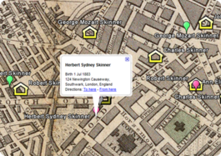
Family tree mapping is the process of geocoding places in family tree files to produce geospatial data suitable for viewing with a virtual globe or 2D mapping program.
S-BASIC was a "structured" BASIC variant, distributed with Kaypro CP/M systems. It was made by Topaz Programming is distributed by Micro-Ap.

Visual FoxPro is a programming language that was developed by Microsoft. It is a data-centric and procedural programming language with object-oriented programming (OOP) features.

Object-oriented programming (OOP) is a programming paradigm based on the concept of objects, which can contain data and code: data in the form of fields, and code in the form of procedures. In OOP, computer programs are designed by making them out of objects that interact with one another.
References
- ↑ Larry Daniel; Paula Loree; Angela Whitener (2002). Inside MapInfo Professional. Thomson Delmar Learning. ISBN 0-7668-3472-7.
| Authority control databases: National |
|---|
| | This cartography or mapping term article is a stub. You can help Wikipedia by expanding it. |
| | This programming-language-related article is a stub. You can help Wikipedia by expanding it. |