Mapping of Venus

Last updated
Global surface of Venus Venus Rotation Movie.gif
Global surface of Venus

The mapping of Venus refers to the process and results of human description of the geological features of the planet Venus. It involves surface radar images of Venus, construction of geological maps, and the identification of stratigraphic units, volumes of rock with a similar age.

Contents

Satellite radar provides imagery of the surface morphology by using the physical properties of wave reflection. Long wavelength microwaves are used to penetrate the thick, cloudy atmosphere of Venus and reach to the surface. Different surface features reflect waves with different strengths of signal, producing images from which the maps are constructed.

After collection of the images of the Venusian surface, scientists started to map and identify different geologic materials and units according to distinctive surface features. Different groups of scientists analyzed different mapping areas, schemes and interpretation of features observed, to produce a classification of the units and comparison of their mapping.

Overview

Planet Venus - old versus newly processed views (Mariner 10; 1974/2020) PIA23791-Venus-RealAndEnhancedContrastViews-20200608.jpg
Planet Venus – old versus newly processed views (Mariner 10; 1974/2020)

Before the development of radar-based observation, the thick yellow Venusian atmosphere hid surface features. [1] In the 1920s, the first Venus ultraviolet project captured the thick atmosphere of Venus, but provided no information about the surface.

Venera program

Venusian cloud structure captured by the Pioneer Venus Orbiter using ultraviolet in 1979. Venus clouds seen by Pioneer Venus Orbiter.jpg
Venusian cloud structure captured by the Pioneer Venus Orbiter using ultraviolet in 1979.

From 1961 to 1984, the Soviet Union developed the Venera probes for surface mapping by radar. The Venera 4 (on October 18, 1967) was the first lander to make a soft landing on Venus (also the first for another planetary object). The probe operated for about 23 minutes before being destroyed by the Venusian atmosphere. The Venera series space probes returned radar images of the Venusian surfaces, [2] shown as below with the landing locations of the probes.

Position of Venera landing sites and the radar topography obtained. Red points denote sites returning images from the surface, black central dots sites of surface sample analysis. VenusLanderTopo.jpg
Position of Venera landing sites and the radar topography obtained. Red points denote sites returning images from the surface, black central dots sites of surface sample analysis.

Magellan mission

Synthetic Aperture Radar (showing right-looking in this diagram). Scattometer principle.GIF
Synthetic Aperture Radar (showing right-looking in this diagram).

The global surface of Venus was first mapped by the Magellan orbiter during 1990–1991 with 50 km spatial and 100 m vertical resolution. During three orbit regimes, the surface images were transmitted back to the Earth. These three orbiting motions of the spacecraft are called mapping cycle 1, 2 and 3.

During the mapping cycle 1 (left-looking) radar surface mapping on Venus (September 15, 1990 to May 15, 1991), around 70% of the Venusian surface was mapped by synthetic aperture radar. In cycle 2 (right-looking), 54.5% of the surface was mapped, mainly the south pole regions and gaps from cycle 1 during May 15, 1991 to January 14, 1992. Combining cycle 1 and 2 results in a total coverage of 96% of Venusian surface mapped. Cycle 3 (left looking) filled remaining gaps and collected stereo imagery of approximately 21.3% of the surface, increasing the total coverage to 98%. [3] [4] [5]

SAR image on Venus. This map is a mosaic of the "left-looking" data collected during cycle 1, produced by the USGS of the Magellan images. Magellan - cycle 1 map - 1298972763463430062.580622.jpg
SAR image on Venus. This map is a mosaic of the "left-looking" data collected during cycle 1, produced by the USGS of the Magellan images.

Proposed future InSAR mapping

Hypothetical satellite using InSAR to measure small scale earthquakes NASA InSAR satellite measuring earthquakes.jpg
Hypothetical satellite using InSAR to measure small scale earthquakes

The use of Interferometric synthetic aperture radar (InSAR) for mapping Venus has been proposed. [6]

Instead of surface mapping by SAR as done by previous missions, InSAR would measure the terrain motions during events such as earthquakes or tectonic movements. By performing the radar mapping at two separated times (before and after an event) over the same area, the terrain changes could be revealed. [6] [7]

Mapping strategies

From the Magellan mission data, 3 types of images have been produced: (1) SAR images, (2) topographic images and (3) meter scale slope image. [7] [8]

SAR imaging

SAR images provide the highest resolution data set. Microwave radiation is used to penetrate the thick atmosphere and map the surface of Venus.

The SAR images are black and white images, which show the surface features using the intensity of radar return (echo), either due to surface roughness or orientation. [7] For SAR imaging, spacecraft do not point directly downward (nadir) but slightly to the side—anywhere from about 10° to 45°. If the surface being mapped is smooth, the incident radar pulse will be reflected away from the spacecraft, resulting in a weak echo, which is represented by darker regions SAR images. On the other hand, if the surface is rougher, then more of the radar wave will be backscattered, and the intensity of echo will be stronger, which are represented by brighter areas in SAR images.

SAR images do not provide the color of surface, only the intensity of reflection of radar waves on the surface at a particular incidence angle. For example, when there is a light source shining on the blue cap on the left (left-looking), there will be shadows on the other side of the cap where light waves are blocked by the cap and no reflection occurs. If the looking direction is changed to the right, the shadowing (dark on SAR image) part will be at the opposite side.

Real life example on difference in looking direction in SAR images. Same object with difference looking direction shows completely different result in SAR image. Looking direction.png
Real life example on difference in looking direction in SAR images. Same object with difference looking direction shows completely different result in SAR image.
Left (left-looking) and right (right-looking) images showing the difference in SAR images on the same location on Venus. (Venus images extracted from USGS) Leftrightvenus.jpg
Left (left-looking) and right (right-looking) images showing the difference in SAR images on the same location on Venus. (Venus images extracted from USGS)

The USGS Branch of Astrogeology [9] has produced full resolution radar maps (also known as FMAPs) of Venus from the SAR data collected from the mission, called the Magellan F-BIDRs (Full resolution Basic Image Data Records). The maps have a coverage of around 92% (combination of the 2 left-looking cycles). [3] [10] The resolution is 75 m/pixel, which is the highest resolution Venusian map.

Topographic mapping

Topographic images were collected using radar altimetry. Compared to the SAR images, the topographic images have a significantly lower resolution of around 3–5 km/pixel. These images show lower elevations with darker pixels with higher elevations are shown with brighter pixels. Despite the low resolution, it is useful to study the regional feature of Venus, including initial evidence for the existence of rift zones. [7]

Topographic Map of Venus Venus topo merc.jpg
Topographic Map of Venus

There are three types of topography on Venus

  1. Highlands with elevation greater than 3 km, cover about 10% of the surface
  2. Deposition plains with elevations around 0 to 2 km, cover more than 50% of the surface
  3. Lowlands (accumulation of eroded highlands) with negative elevation, cover the rest of the surface

The surface observation includes impact craters, volcanoes, and lava flow channels, which give clues to estimate the surface age, possible global resurfacing events, tectonic activities, internal structure and surface processes.

Unit classification and mapping schemes

Different missions have mapped different cartographic quadrangles of the surface of Venus. They applied different mapping schemes and came up with different classifications of Venusian units.

Here is a table comparing the different mapping scheme and unit identification by the Magellan science team (1994), [11] Vicki L. Hansen (2005) [12] and Mikhail A. Ivano and James W. Head (2011). [13] The possible matching of the above units are in accordance with their radar backscatter and surface features.

Mapping GroupsMagellan Science Team (1994)Mikhail A. Ivanov and James W. Head (2011)Vicki L. Hansen (2005)
Mapping SchemeGlobal-scale geologic mappingscheme

(defined by difference in radar backscatter, surface texture and topographic)

Stratigraphic ClassificationScheme

(defined to global stratigraphy with a division of geologic time)

(defined by local formations and deformations, instead of global stratigraphic)
Unit ClassificationStratigraphic Units:Stratigraphic Unit
(Tessera is not in this classification)1. Tessera (t)1. Tessera terrain

(Further classification into 7 types, according to the features in Hansen and Willis' paper in 1996 [14] )

2. Mountain belts (mb)
1. Lineated plains3. Densely lineated plains (pdl)2. Flow material from different origin locally
2. Reticulate plains4. Ridged plains (pr)
/5. Regional plains (rp, upper and lower units)
3. Bright plains/
4. Dark plains6. Smooth plains (ps)
5. Mottled plains7. Shield plains (psh)
8. Shield clusters (sc)
6. Digitate plains (lava flow fields)9. Lobate plains (pl)
Geomorphic units:Structural features
1. Complex ridged terrain (CRT or tesserae)(Tesserae is a geological material instead of structural features)
2. Ridged and fractured terrain
3. Ridge belts (including mountain belts)1. Groove belt (gb)1. Secondary Structures
4. Fracture belts
/2. Rift zones (rz)
Deposits:

- Associated with impact events

Impact Crater Forming Materials
1. Crater material1. Crater materials (c)1. Crater material
2. Bright diffuse deposits2. Impact crater flow material (cf)2. Flooded crater material
3. Dark diffuse areas

The details of the above mapping scheme and units will be discussed one by one below.

Geologic mapping scheme by the Magellan

The global-scale geologic mapping scheme by the Magellan science team was a very early mapping done by the Magellan mission (1990–1991). Instead of identifying different geological materials, it basically grouped the global surface units with different radar backscatter (white and dark in SAR images), topography and surface texture.

The mapped units and their characteristics are listed below.

Stratigraphic units

The stratigraphic units in this mapping scheme are classified as 6 types of plains:

Stratigraphic units
UnitsRadar backscatter Surface featuresInterpreted geological materials
Lineated plainsModerate and homogeneousAbundant fractures, forming grids or orthogonal patterns/
Reticulate plainsIntermediate and homogeneousAbundant and low sinuous ridges/
Dark plainsHomogeneous, dark local areasSmoothLava flow
Bright plainsHomogeneous, bright local areas/Lava flooding with extension and rifting
Mottled plainsExtensive areas with both bright and dark materialsMottled textures with abundant small shields and despoites[ clarification needed ]/
Digitate plainsBright and dark depositesIn digitate patternsLava flow fields associated with coronae

Geomorphic units

The units are defined by groups of structural features of commonly higher elevation area with ridges and deformations:

Geomorphic units
UnitsComplex ridged terrain (CRT or tesserae)Ridged and fractured terrainRidge beltsFracture belts
Surface featuresRidges and fractures with deformationsSame as CRT, but with a single direction of deformations dominateLinear, which parallel to the nearby ridgesDense parallel linear fractures, mainly around equatorial and southern regions
TopographyRegional highland areasRegional highland areasElevated ridges/
Images
Aphrodite Terra, a complex terrain Aphrodite Terra on Venus.jpg
Aphrodite Terra, a complex terrain
Lineated terrain on Alpha Regio Alpha Regio, northern part, 781-,663,-118.jpg
Lineated terrain on Alpha Regio
Northern part of the Akna Montes (mountains) with a ridge belt. Akna montes PIA00250.jpg
Northern part of the Akna Montes (mountains) with a ridge belt.
Lineated plains PIA00085-cropped.jpg
Lineated plains

Deposits

The deposits are mainly the impact crater materials and its deposits:

Deposits
UnitsRadar backscatter Surface featuresImage
Crater materialImpact ejecta (bright)/
Mapping of Venus crater based on 3 units: (1) crater material; (2) radar-bright diffuse deposits; and (3) dark diffuse deposits Crater on venus.jpg
Mapping of Venus crater based on 3 units: (1) crater material; (2) radar-bright diffuse deposits; and (3) dark diffuse deposits
Bright diffuse depositsRadar-bright materialsForming "wispy patterns"
Dark diffuse depositsRadar-dark materialsParabola in shape

Stratigraphic classification scheme

One way to do mapping on Venus and characterization on the geological units on Venus is by the stratigraphic classification scheme. [15] Mikhail A. Ivano and James W. Head (2011) mapped the area of geotraverses at 30°N [16] and 0°N. They traced and discussed the global spatial distribution of rock-stratigraphic units and structure, and suggested their time correlation and geological history. [13]

Stratigraphic units

This mapping scheme suggests that there are approximately 12 global stratigraphic units on Venus which are present on different quadrangles. [13] These stratigraphic units and landforms are listed below in terms of mechanism from the oldest to the youngest.

Tectonic units

Tectonic units are formations due to large-scale crustal processes. In this mapping scheme, these surface units are grouped into possible same set of geological materials, shown by similar surface features.

Tessera regions (t)
Outline of tessera terrain imposed on the 'GIS Map of Venus' Tessera Terrain on Venus gif.gif
Outline of tessera terrain imposed on the 'GIS Map of Venus'
Maxwell Montes's tessera (t) terrain seen in appearing as white in SAR image Maxwell Montes of planet Venus.jpg
Maxwell Montes's tessera (t) terrain seen in appearing as white in SAR image

Tesserae are regions of heavily deformed terrain, mostly located on highland areas (greater than 2 km in elevation) on Venus. This tectonic feature -or uni— is thought to be the oldest material on Venusian surface with highest level of tectonic deformation. [17] [18] It is of high topography and seen in white on the SAR images with high radar backscatter. [19] The materials composed tessa terrain, which was named as unit Tt in the mapping of V-17(Basilevsky, A. T.,1996). [20]

The intersecting of material and tectonic structures are the defined characteristic of tessera, but the sets are not always seen in the images. [13] Due to the heavy tectonic deformation, it contains both contractional features of ridges and extensional features of graben and fractures. [13]

The boundaries of tessera shows embayment by other materials of other units. By this cross-cutting relationship, it provides evidence of tessera being the oldest unit within the strata. [13]

Densely lineated plains
Densely lineated plains (pdl) on Venus PIA00085-cropped.jpg
Densely lineated plains (pdl) on Venus

The densely lineated plains unit (pdl) is defined by the dense and parallel lineaments packed on the unit. [13] They make up a small area on Venus's global surface of around 7.2 x 10⁸ km2. [13] The lineament is the pattern of deformation, which make it a typical structural–material unit. [13]

There is evidence showing the embayment of tessera by pdl's material in some tessera margins. Thus, it is possible that this unit is younger than the tessera unit. [13]

In SAR images, it also shows a high backscatter imagery, but lighter than that of tessera.

Ridged plains (pr)
The ridge belt that forms in the western part of the elevated smooth plateau of Lakshmi plain Akna montes PIA00250.jpg
The ridge belt that forms in the western part of the elevated smooth plateau of Lakshmi plain

The ridged plains unit are lava plains deformed by ridges. They have a smooth surface with relatively higher elevation than the surroundings. [13] The ridges are usually symmetrical in cross-section and collected into prominent belts. [21] [22]

There is evidence in places showing that pr unit is embaying the t and pdl unit. Also, the deformation of pr took place after the formation of t and pdl units. Thus, pr unit is possibly younger than both unit t and pdl. [13] As most of the deformation features on pr is far away from that on t and pdl units, it is difficult to tell the age relationship of deformation directly. [23] [24] [25] However, there are some tessera-like deformations additional to the ridge belts, it suggests there are some possible overlapping of formation time in unit t and pr. [13]

In SAR images, pr units have noticeably higher radar backscatter than surrounding regional plains, but lower than tessera (t) and densely lineated plains (pdl) units. Ridges planes have older ages compared to surrounding regional plains (pr) due to the difference in radar albedo and embayment relationships suggested by McGill and Campbell (2006). [26]

The major occurrence of this unit is located among Vinmara, Atalanta, Ganiki, and Vellamo Planitiae, shich in a broad fan-shape, [27] [28] [29] [30] and also appears between Ovda and Thetis Regiones and in the southern hemisphere within Lavinia Planitis. [31] [32]

Some researchers mapped ridges of the pr unit as deformed structures instead of a unit. [33] [34] [35] [36] [37]

Mountain belts (mb)
Perspective view of Ishtar Terra showing the mountain belt (mb) units with Akna Montes and Freyja Montes along the western and northwestern edge of Lakshmi Planum, and Maxwell Montes along its eastern edge PIA00093 Perspective View of Ishtar Terra.jpg
Perspective view of Ishtar Terra showing the mountain belt (mb) units with Akna Montes and Freyja Montes along the western and northwestern edge of Lakshmi Planum, and Maxwell Montes along its eastern edge

The mountain belts unit is the only real mountain range on Venus in the area surrounding Lakshmi Planum, which covers only 1.3 x 10⁶ km2 of the Venusian global surface, [27] [38] [39] [40] [41] while involves structural deformation of different materials in their formation. [13] There are in total four major mountain belts mapped on Venus, including the belts of Danu Montes, Akna Montes, Freyje Montes and Maxwell Montes (the highest mountain on Venus with elevation of around 12 km). [13]

When looking at the cross-cutting relationship, the inner ridges of the belts seems to be embayed by the material of regional plains (pr), which covered the plateau surface. There is later deformation in terms of tilting towards the belts and wrinkle ridges parallel to the belt. It suggested formation formed right before the deposition of regional plains and later deformation of the belts. [13]

Shield plains
Formation of Shield Domes. Formation of Shield Domes.gif
Formation of Shield Domes.
Accruva Formation. Evaluation Diagram of Shield plain formation from Shield Domes over time Accruva Formation - How multiple shield domes can be formed within the shield plain formation over time.png
Accruva Formation. Evaluation Diagram of Shield plain formation from Shield Domes over time

The shield plains units (psh) refers to plains with volcanic edifices of shield-like features. [42] [43] [44] In most of the psh regions. the plains are concentrated and forms a group. It is the oldest unit in the strata showing no widespread deformation, in which only little tectonic deformation is observed, such as ridges and fractures. [13] Compared to the above units, this unit seems to cover a high proportion of the Venusian surface at around 79.3 x 10⁶ km2. Although the distribution of psh is widely spread and homogeneous, there are also some regions with no psh units, including the Lakshmi Planum and some lowland of regional plains, [13] The shield plains are formed from shield domes over time and suggested that psh may be associated as volcanic plains with small sources of volcanic materials and mildly deformed by tectonics. [13]

There are embayment relationships, showing that this unit is younger than the above highly tectonized units (t and pdl) at a global scale. However, the absence of the unit in some regions makes this unit difficult to fit into the strata, especially between the highly tectonized units mentioned above, and regional plains which will be mentioned in the next section. [13]

In SAR images, the psh unit shows a higher radar backscatter compared to surrounding overlaying regional plains, still lower than units of t, pdl and pr. [13]

Regional plains (rp)

The regional plains unit (rp) is the most widespread unit on the Venusian surface of about 182.8 x 10⁶ km2. [13] It is defined as smooth and homogeneous plains, which are deformed into networks of linear subparallel or intersecting ridges. [45] This unit is interpreted as having volcanic origin with deformation of wrinkle ridges superimposed. However, the source of volcanism is not obvious in the Magellan data. [13]

Regional plains are divided into abundant lower unit (rp1, Rusalka Formation) with smooth surface and relatively low radar backscatter and upper unit (rp2, Ituana Formation) with also smooth surface, but higher radar albedo. Wrinkle ridges heavily deform the lower unit while moderately deforming the upper unit. The lower unit is heavily tectonized and embayed by lava plains and flows. The younger upper unit is lacking in large heavily tectonized tessera regions. [13]

In SAR images, they show as an intermediate level of radar backscatter.

Shield clusters
Volcanic Domes on Venus PIA00215-cropped.jpg
Volcanic Domes on Venus

The Shield clusters unit (sc) is similar to shield plains, but tectonically undeformed. Based on the analysis by Crumpler and Aubele (2000), [46] 10% of this unit shows evidence that it is younger than regional plains (rp). [47] Some of the small shield clusters are founded embaying the regional plains of both lower and upper layers, while in some regions, this unit is found on top of the rp unit and deformed together by wrinkled ridges. [13]

Smooth plains
Adivar crater. Dark (Smooth plain) deposition around the crater PIA00083-cropped.jpg
Adivar crater. Dark (Smooth plain) deposition around the crater

The Smooth plains unit (ps) belongs to Gunda Formation, which is a smooth and featureless surface without tectonic marks. It only makes up about 10.3 x 10⁶ km2 of Venusian surface. These plains are usually do not have impact craters, which is tectonic undeformed. [13] These plains are rarely with low domes. These suggested three type of setting for this unit:

(1) Many fields of smooth plains are near to the regions with young volcanism (such as Bell Regio) with the lobate plains (pl). However, the relationship of smooth and lobate plains is uncertain.

(2) Some of the unit is located as deposition around an impact crater, possibly associated with the impact events. [48] [49]

(3) small ps units are inside the tessera regions (such as Ovda Regio), which may associate with a volcanic origin,

Due to the usual higher elevation of smooth plains, it is possible that the volcanic material of smooth plains is a younger unit. [13]

Lobate plains

The Lobate plains unit (pl) is a smooth surface crossed with some extension features associated with rift zones. These features make up to around 37.8 x 10⁶ km2, which is significant. The origin of lobate plains is thought to be associated with large volcanoes, which sometimes appear with large dome-shaped rises. [13] One possible origin of this unit is from massive and multiple eruptions from large and localized volcanoes with little later extensional deformation. [13]

By cross-cutting relationships, the plains embay the wrinkle ridges containing regional plains, which suggested that lobate plains are younger. [13] However, as the lobate plains, smooth plains, shield cluster and rift zones are often seen as small fractures, it is difficult to tell their time relationship.

The SAR image shows uneven radar back-scatter flow-like pattern.

Structural Units

Structural units are formed due to deformation. The resultant properties depend on the stress applied to the formation and the stain of the rocks.

Tessera-forming structures (ridges and grooves)

Ridge structures are mainly discussed in the ridged plains (pr) part above.

Groove belts (gb) belong to the Agrona Formation, which refers to dense extensional structures. This unit appears to be sets of subparallel lineaments of fractures or grabens. [13] This deformation unit makes up to around 37.1 x 10⁶ km2 of the Venusian surface. These fractures are the most obvious and are very abundant on the surface of Venus, and crosses different units on the surface. It appears to be a younger unit on the surface. However, some vast plains units are found embaying the grooves in some areas. It suggests the formation of gb unit before the formation of plains. [13]

The major difference between grooves unit and dense lineated plains are that the former is belt-like and the latter is patch-like. [13]

It is very important to map these fractures, as sometimes the rock unit may be too deformed and is not recognizable, which it can be mapped as "fractured plains materials" according to the guidelines of Wilhelms (1990). [50]

In SAR image, these fractures are of high radar albedo, as high as that of the tessera unit. [13]

Rift zones

The Rift zones unit (rz) belongs to the Devana Formation, which is also made up of dense extensional structures with defined numbers of fissures and troughs containing flat-floors. [13]

It is found that the rift zones are usually related to the lobate plains, which may indicate that the rifting is related to the young volcanism and also young volcanic plains formed. [13]

Impact Crater Forming Materials
Dickinson Crater on Venus. The structure can be clearly seen. Venus Dickinson Crater.jpg
Dickinson Crater on Venus. The structure can be clearly seen.

Just like the impact craters on Earth and other terrestrial planetary bodies, impact craters on Venus include central peaks, rims, floors, walls, ejected deposits and outflows from the craters. There are two groups of materials, including undivided crater materials (c) and impact crater flow material (cf). [51]

The study of impact craters on Venus is important to discover its geological history. In testing the model of catastrophic and equilibrium Model (another hypothesis other than global stratigraphy [52] ) on Venus, it is found that the older regional plains (rp) are embaying only around 3% of the impact craters and the younger lobate plains (pl) are embaying around 33% of the impact crater on Venus. It suggested that there are likely to have been at least two geological periods on Venus:

(1) Earlier global volcanic regime stage (Formation of older regional plains), when the high rate of volcanic activities overwrote the marks of impact cratering

(2) Later network-rifting and volcanic regime stage (Formation of younger lobate plains), when the intensity of volcanism is reduced and allowed more impact cratering to be left on the surface.

Thus, the studying of crater distribution and randomness may give clues for Venusian geological history. [53]

Global stratigraphy

A simple Venus global strata base on Ivanov and Head's model (2011) (Note that it is just a simple global strata, not every region on Venus has this strata.) Venus strata.jpg
A simple Venus global strata base on Ivanov and Head's model (2011) (Note that it is just a simple global strata, not every region on Venus has this strata.)

Under the Global stratigraphic Classification Scheme, by correlating the units mentioned above (Mikhail A. Ivano and James W. Head, 2011), [13] the researchers suggested three phases of Venusian geological history:

(1) The earliest period, Fortunian Period, involved intensive formation of tessera (t) (building of thick crust at the same time).

(2) Then, it came to Guinevere Period, which firstly, there was formation of Atropos (dense lineated plains, pdl), Lavinia (Ridged plains, pr), Akna (Mountain belts, mb), and Agrona (groove belt, gb). Later, there was global emplacement of Accruva (shied plains, psh), Rusalka (lower regional plains, rp1), and Ituana (upper regional plains, rp2) Formations. There are events of wrinkle ridges formed around the global. Mostly of the surface of Venus was resurfaced in this period

(3) In the Altlian period, there are limited formations of smooth plains (ps), Gunda Formation, and shield clusters (sc), Boala Formation, possibly due to Atlian volcanism. There was significant reduction in the rate of volcanism and tectonism. [13] However, these proposed events, and formation of units are not yet fully explained by a complete Venus geological model, such as resurfacing of Venus or heat-pipe hypothesis.

The mapping scheme by Vicki L. Hansen (2005)

The mapping scheme applied by Vicki L. Hansen is mainly regional based, instead of using global stratigraphy as Mikhail A. Ivano and James W. Head did. This mapping scheme focuses on the regional origin of geological materials. [14]

Tectonic units

There are only two major units classified under this group. These two units are further classified below: [14]

Tessera Terrain

Tessera terrain is seen locally the oldest unit on Venus.

It can be further classified into eight groups according to the deformation features: [14]

  1. Fold Terrain
  2. "Lava Flow" Terrain
  3. S-C Terrain
  4. Extended Fold Terrain
  5. Folded Ribbon Terrain
  6. Basin-and-Dome Terrain
  7. “Star” Terrain
  8. Tessera Inliers

Some of the terrains have multiple deformations, but it is not essential for them to have complex deformation. [14]

Flow materials with different origins

The relatively low-lying plains are mapped as flows from different origins locally. These materials are thought to be thick young sediments deposited rapidly. In SAR images, the flows material can be radar-dark or bright. [14]

Structural features

Structural deformation is treated as a feature instead of a unit. [14]

There are some common features mapped, such as linear fractures, ridge and wrinkled ridge identified in many regions, and other local features only found in some regions, such as dome, belt fractures, ribbon, graben, etc. [14]

Impact crater-forming materials

The classification of impact crater-forming materials are (1) crater materials and (2) flooded crater materials, [12] which is similar to the stratigraphic classification scheme.

Differences between mapping schemes

Here are some differences on the terminology and classification of units:

(1) The term "complex ridged terrain (CRT or tesserae)"

(2) Treating tessera terrain as a global stratigraphic unit

(3) Terminology and classification of "plains"

The terminology of "complex ridged terrain (CRT or tesserae)"

Hansen (2005) suggested that the tessera terrain should not be named as "complex ridged terrain (CRT)". For the term "complex ridged terrain (CRT)" used by the Magellan science team (1994), [11] it carries confusions. [12] Ridges can be also understood as fold, which is a contractional feature. However, not all tessera deformation are due to contraction.

Treating tessera terrain as a global stratigraphic unit

For treating tessera terrain as the oldest global unit in the Stratigraphic Classification Scheme, it is questioned under Hansen (2005)'s mapping scheme. [12] Although it is commonly the oldest unit mapped in different Venusian areas, it may not be the case for everywhere. The assumption of all the tessera are formed at the same time and the oldest around the global are remained untested.

Terminology and classification of "plains"

There are a major difference in terminology between the Stratigraphic Classification Scheme and Hansen (2005)'s mapping scheme, which Hansen (2005) suggested that "fold material" should be used instead of "plains with different surface features". It can be explained by three reasons: [12]

  1. "Plains" is not used to describe geological material, but surface physical features.
  2. Also, according to fundamental geological mapping principles, secondary structure (such as lineated, ridged and wrinkled) should not be used to define geological units.
  3. There is no evidence that the Venusian plains are volcanic products resulted from extensive flood lava

Thus, in Hansen's mapping scheme (2005), plains are defined as flow from different local origins in regional mapping.

Quadrangles' mapping of Venusian geological units

Quadrangles on Venus Venus quadrangle layout.gif
Quadrangles on Venus

The quadrangles mapping and classification of geological units by different groups of researchers are mainly based on regional units mapped locally. Different groups have their own grouping of units, which are not fully coherent with others work and the proposed global stratigraphy. Also, there are some regional features being classified regionally.

Cartography

The United States Geological Survey defines sixty-two cartographic quadrangles for the surface of Venus, [54] with V-1 as the north pole region and V-62 as the south pole region. Base on the FMAPs, different groups of Venus researchers are mapping different quadrangles for the surface of Venus, resulting in different type of units defined.

Here are some examples of quadrangle mapping and their ways of classifying and grouping observed geological units. Some of them are having a similar time sequence as the global stratigraphy mentioned above and will be highlighted below.

Examples of quadrangle mapping unit classification

Here are the list of examples comparing the mapping schemes and units in quadrangles (regional mapping):

QuadranglesMapping group & year of publicationMapping schemeStratigraphic units identifiedStructural units mappedOther information
V-5 Barrymore Quadrangle Mapping [55] Elizabeth Rosenberg and George E. McGill, 2001Similar to the global stratigraphic mapping scheme with the oldest tessera, followed by dense lineated materials, up to other younger plains materials.
  • Plains materials (p, local plains and regional plains of different features)
  • Flow materials (f)
  • Corona materials (co)
  • Linear belts (bl)
  • Dense lineated materials (ld)
  • Tessera materials (t)
  • Impact crater materials (c)
  • Linear belts
  • Wrinkle ridges
  • Radar-bright
  • Linear features
  • Coronae
  • Corona-like features
/
V-13 Nemesis tesserae quadrangle mapping [51] Mikhail A. Ivanov and James E. Head, 2005Global stratigraphy units classification
  • Plains materials of dense lineated plains (pdl), ridged and grooved plains (prg), shield plains (psh), wrinkle ridged plains (pwr) and smooth plains (ps)
  • Tessera material of tessera unit (t)
  • Crater material of undivided crater materials (c) and impact crater flow material (cf)
//
V-35 Ovda Regio quadrangle mapping [56]
Ovda Regio in V-35 Ovda Regio.jpg
Ovda Regio in V-35
Leslie F. Bleamaster, III, and Vicki L. Hansen, 2005Mapping by grouping local formations and deformations, instead of global stratigraphic
  • Western regions (mainly flow materials with different origin and Ovda Regio tessera terrain )
  • Northeastern region (mainly flow materials with different origin and tessera terrain of Thetis Regio and undivided part)
  • South-central to southeastern region (mainly flow materials with different origin and Boszorkany Dorsa basal material)
  • Widespread units (Chasmata flow material, crater material, flooded crater material and tessera inlier terrain)
/
  • Regionally, the tessera unit are also the oldest unit with younger flows embaying it.
V-48 Artemis Chasma quadrangle mapping [57] Roger A.Bannister and Vicki L.Hansen, 2010Mapping by grouping local formations and deformations, instead of global stratigraphic
  • Crater materials (c)
  • Flow and shield materials (f)
  • Tectonic and fracture terrain units (fr, t)
  • Radar unit (rf)
/
  • Tectonic and fracture terrain units is the oldest unit as it is mainly the tessera unit.
  • All crater material and radar unit forms throughout the whole time period.
  • The radar units are the high backscatter radar facies marked by penetratively developed,[ clarification needed ] and it does not represent single geological units.

Examples of regional geological mapping

Here is an example of geological map in quadrangle V-20. The units are classified as (1) tessera material, (2) plains materials, (3) materials of coronae and (4) materials of domes and miscellaneous flows, with structures like ridges, wrinkle ridge and lineations.

Geological map of V-20Original SAR image of V-20
V-20 Venus geologic map V-20 Venus Geologic Map.jpg
V-20 Venus geologic map
Irnini Mons on Venus (V-20) Irnini mons on venus v-20.jpg
Irnini Mons on Venus (V-20)

Related Research Articles

<span class="mw-page-title-main">Maxwell Montes</span> Montes on Venus

Maxwell Montes is a mountain massif on the planet Venus, of which Skadi Mons is the highest point on the planet's surface.

<span class="mw-page-title-main">Geology of Venus</span> Geological structure and composition of the second planet from the Sun

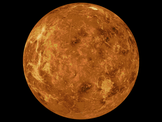
The geology of Venus is the scientific study of the surface, crust, and interior of the planet Venus. Of all the other planets in the Solar System, it is the one nearest to Earth and most like it in terms of mass, but has no magnetic field or recognizable plate tectonic system. Much of the ground surface is exposed volcanic bedrock, some with thin and patchy layers of soil covering, in marked contrast with Earth, the Moon, and Mars. Some impact craters are present, but Venus is similar to Earth in that there are fewer craters than on the other rocky planets that are largely covered by them. This is due in part to the thickness of the Venusian atmosphere disrupting small impactors before they strike the ground, but the paucity of large craters may be due to volcanic re-surfacing, possibly of a catastrophic nature. Volcanism appears to be the dominant agent of geological change on Venus. Some of the volcanic landforms appear to be unique to the planet. There are shield and composite volcanoes similar to those found on Earth. Given that Venus has approximately the same size, density, and composition as Earth, it is plausible that volcanism may be continuing on the planet today, as demonstrated by recent studies.

<span class="mw-page-title-main">Cleopatra (crater)</span> Crater on Venus

Cleopatra, initially called Cleopatra Patera, is an impact crater on Venus, in Maxwell Montes.

<span class="mw-page-title-main">Baltis Vallis</span> Vallis on Venus

Baltis Vallis is a sinuous channel on Venus ranging from 1–3 km (0.62–1.86 mi) wide and ~6,800 km (4,200 mi) long, slightly longer than the Nile and the longest known channel of any kind in the Solar System. It is thought the channel once held a river of lava. It is a single channel over most of its length, but anastomoses in several sections, for lengths of up to 400 km (250 mi). There appear to be other, smaller channels in the same area, down to the limit of resolution, some of which seem to be tributaries of Baltis Vallis.

<span class="mw-page-title-main">Geology of solar terrestrial planets</span> Geology of Mercury, Venus, Earth, Mars and Ceres

The geology of solar terrestrial planets mainly deals with the geological aspects of the four terrestrial planets of the Solar System – Mercury, Venus, Earth, and Mars – and one terrestrial dwarf planet: Ceres. Earth is the only terrestrial planet known to have an active hydrosphere.

<span class="mw-page-title-main">Victoria quadrangle</span> Quadrangle on Mercury

The Victoria quadrangle is a region on Mercury from 0 to 90° longitude and 20 to 70 ° latitude. It is designated the "H-2" quadrangle, and is also known as Aurora after a large albedo feature.

<span class="mw-page-title-main">Michelangelo quadrangle</span> Quadrangle on Mercury

The Michelangelo quadrangle is in the southern hemisphere of the planet Mercury, where the imaged part is heavily cratered terrain that has been strongly influenced by the presence of multiring basins. At least four such basins, now nearly obliterated, have largely controlled the distribution of plains materials and structural trends in the map area. Many craters, interpreted to be of impact origin, display a spectrum of modification styles and degradation states. The interaction between basins, craters, and plains in this quadrangle provides important clues to geologic processes that have formed the morphology of the mercurian surface.

<span class="mw-page-title-main">Deuteronilus Mensae</span> Mensae on Mars

Deuteronilus Mensae is a region on Mars 937 km across and centered at 43.9°N 337.4°W. It covers 344°–325° West and 40°–48° North. Deuteronilus region lies just to the north of Arabia Terra and is included in the Ismenius Lacus quadrangle. It is along the dichotomy boundary, that is between the old, heavily cratered southern highlands and the low plains of the northern hemisphere. The region contains flat-topped knobby terrain that may have been formed by glaciers at some time in the past. Deuteronilus Mensae is to the immediate west of Protonilus Mensae and Ismeniae Fossae. Glaciers persist in the region in modern times, with at least one glacier estimated to have formed as recently as 100,000 to 10,000 years ago. Recent evidence from the radar on the Mars Reconnaissance Orbiter has shown that parts of Deuteronilus Mensae do indeed contain ice.

<span class="mw-page-title-main">Ovda Regio</span>

Ovda Regio is a Venusian crustal plateau located near the equator in the western highland region of Aphrodite Terra that stretches from 10°N to 15°S and 50°E to 110°E. Known as the largest crustal plateau in Venus, the regio covers an area of approximately 15,000,000 square kilometres (5,800,000 sq mi) and is bounded by regional plains to the north, Salus Tessera to the west, Thetis Regio to the east, and Kuanja as well as Ix Chel chasmata to the south. The crustal plateau serves as a place to hold the localized tessera terrains in the planet, which makes up roughly 8% of Venus' surface area. The kinematic evolution of crustal plateaus on Venus has been a debated topic in the planetary science community. Understanding its complex evolution is expected to contribute to a better knowledge of the geodynamic history of Venus. It is named after a Marijian forest spirit that can appear as both male and female.

Fretted terrain is a type of surface feature common to certain areas of Mars and was discovered in Mariner 9 images. It lies between two different types of terrain. The surface of Mars can be divided into two parts: low, young, uncratered plains that cover most of the northern hemisphere, and high-standing, old, heavily cratered areas that cover the southern and a small part of the northern hemisphere. Between these two zones is a region called the Martian dichotomy and parts of it contain fretted terrain. This terrain contains a complicated mix of cliffs, mesas, buttes, and straight-walled and sinuous canyons. It contains smooth, flat lowlands along with steep cliffs. The scarps or cliffs are usually 1 to 2 km high. Channels in the area have wide, flat floors and steep walls. Fretted terrain shows up in northern Arabia, between latitudes 30°N and 50°N and longitudes 270°W and 360°W, and in Aeolis Mensae, between 10 N and 10 S latitude and 240 W and 210 W longitude. Two good examples of fretted terrain are Deuteronilus Mensae and Protonilus Mensae.

<span class="mw-page-title-main">Glaciers on Mars</span> Extraterrestrial bodies of ice

Glaciers, loosely defined as patches of currently or recently flowing ice, are thought to be present across large but restricted areas of the modern Martian surface, and are inferred to have been more widely distributed at times in the past. Lobate convex features on the surface known as viscous flow features and lobate debris aprons, which show the characteristics of non-Newtonian flow, are now almost unanimously regarded as true glaciers.

The common surface features of Mars include dark slope streaks, dust devil tracks, sand dunes, Medusae Fossae Formation, fretted terrain, layers, gullies, glaciers, scalloped topography, chaos terrain, possible ancient rivers, pedestal craters, brain terrain, and ring mold craters.

<span class="mw-page-title-main">Guinevere Planitia</span>

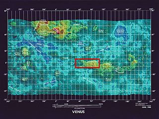
Guinevere Planitia is an expansive lowland region of Venus that lies east of Beta Regio and west of Eistla Regio. These low-lying plains, particularly in the western portion, are characterized by apparent volcanic source vents and broad regions of bright, dark, and mottled deposits. They are the only break in an equatorially connected zone of highlands and tectonic zones. The types, numbers, and patterns of mapped tectonic features and small volcanic landforms in the region provide important detail in the interpretation and evolution of venusian landscape.

<span class="mw-page-title-main">Geodynamics of Venus</span>

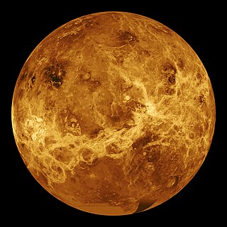
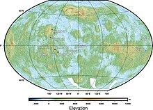
NASA's Magellan spacecraft mission discovered that Venus has a geologically young surface with a relatively uniform age of 500±200 Ma. The age of Venus was revealed by the observation of over 900 impact craters on the surface of the planet. These impact craters are nearly uniformly distributed over the surface of Venus and less than 10% have been modified by plains of volcanism or deformation. These observations indicate that a catastrophic resurfacing event took place on Venus around 500 Ma, and was followed by a dramatic decline in resurfacing rate. The radar images from the Magellan missions revealed that the terrestrial style of plate tectonics is not active on Venus and the surface appears to be immobile at the present time. Despite these surface observations, there are numerous surface features that indicate an actively convecting interior. The Soviet Venera landings revealed that the surface of Venus is essentially basaltic in composition based on geochemical measurements and morphology of volcanic flows. The surface of Venus is dominated by patterns of basaltic volcanism, and by compressional and extensional tectonic deformation, such as the highly deformed tesserae terrain and the pancake like volcano-tectonic features known as coronae. The planet's surface can be broadly characterized by its low lying plains, which cover about 80% of the surface, 'continental' plateaus and volcanic swells. There is also an abundance of small and large shield volcanoes distributed over the planet's surface. Based on its surface features, it appears that Venus is tectonically and convectively alive but has a lithosphere that is static.

<span class="mw-page-title-main">Irnini Mons</span> Mountain on Venus

Irnini Mons is a volcanic structure on the planet Venus, and is named after the Assyro-Babylonian goddess of cedar-tree mountains. It has a diameter of 475 km (295 mi), a height of 1.75 km (1.09 mi), and is located in Venus' northern hemisphere. More specifically, it is located in the central Eistla Regio region at in the V-20 quadrangle. Sappho Patera, a 225 km (140 mi) diameter wide, caldera-like, depression tops the summit of Irnini Mons. The primary structural features surrounding Irnini Mons are graben, seen as linear depressed sections of rock, radiating from the central magma chamber. Also, concentric, circular ridges and graben outline the Sappho Patera depression at the summit. The volcano is crossed by various rift zones, including the north-south trending Badb Linea rift, the Guor Linea rift extending to the northwest, and the Virtus Linea rift continuing to the southeast.

<span class="mw-page-title-main">Tessera (Venus)</span>

A tessera is a region of heavily deformed terrain on Venus, characterized by two or more intersecting tectonic elements, high topography, and subsequent high radar backscatter. Tesserae often represent the oldest material at any given location and are among the most tectonically deformed terrains on Venus's surface. Diverse types of tessera terrain exist. It is not currently clear if this is due to a variety in the interactions of Venus's mantle with regional crustal or lithospheric stresses, or if these diverse terrains represent different locations in the timeline of crustal plateau formation and fall. Multiple models of tessera formation exist and further extensive studies of Venus's surface are necessary to fully understand this complex terrain.

<span class="mw-page-title-main">Lada Terra</span>

Lada Terra is a major landmass near the south pole of Venus which is centered at 60°S and 20°E and has a diameter of 8,615 kilometres (5,353 mi). It is defined by the International Astronomical Union as one of the three "major landmasses," or terrae, of Venus. The term "landmass" is not analogous to the landmass on Earth, as there are no apparent oceans on Venus. The term here applies to a substantial portion of land that lies above the average planetary radius, and corresponds to highlands.

<span class="mw-page-title-main">Surface features of Venus</span>

The surface of Venus is dominated by geologic features that include volcanoes, large impact craters, and aeolian erosion and sedimentation landforms. Venus has a topography reflecting its single, strong crustal plate, with a unimodal elevation distribution that preserves geologic structures for long periods of time. Studies of the Venusian surface are based on imaging, radar, and altimetry data collected from several exploratory space probes, particularly Magellan, since 1961. Despite its similarities to Earth in size, mass, density, and possibly composition, Venus has a unique geology that is unlike Earth's. Although much older than Earth's, the surface of Venus is relatively young compared to other terrestrial planets, possibly due to a global-scale resurfacing event that buried much of the previous rock record. Venus is believed to have approximately the same bulk elemental composition as Earth, due to the physical similarities, but the exact composition is unknown. The surface conditions on Venus are more extreme than on Earth, with temperatures ranging from 453 to 473 °C and pressures of 95 bar. Venus lacks water, which makes crustal rock stronger and helps preserve surface features. The features observed provide evidence for the geological processes at work. Twenty feature types have been categorized thus far. These classes include local features, such as craters, coronae, and undae, as well as regional-scale features, such as planitiae, plana, and tesserae.

<span class="mw-page-title-main">Upper plains unit</span> Surface features of Mars

The upper plains unit is the remnants of a 50-100 meter thick mantling that has been discovered in the mid-latitudes of the planet Mars. It was first investigated in the Deuteronilus Mensae region, but it occurs in other places as well. The remnants consist of sets of dipping layers in impact craters, in depressions, and along mesas. Sets of dipping layers may be of various sizes and shapes—some look like Aztec pyramids from Central America.

<span class="mw-page-title-main">EnVision</span> Proposed mission to Venus

EnVision is an orbital mission to Venus being developed by the European Space Agency (ESA) that is planned to perform high-resolution radar mapping and atmospheric studies. EnVision is designed to help scientists understand the relationships between its geological activity and the atmosphere, and it would investigate why Venus and Earth took such different evolutionary paths. The probe was selected as the fifth medium mission (M5) of ESA's Cosmic Vision programme in June 2021, with launch planned for 2031. The mission will be conducted in collaboration with NASA, with the potential sharing of responsibilities currently under assessment.

References

  1. Ross, F. E. (1928). "Photographs of Venus". Astrophysical Journal. 68–92: 57
  2. Goldstein, R. M.; Carpenter, R. L. (1963). "Rotation of Venus: Period Estimated from Radar Measurements". Science. 139 (3558): 910–911.
  3. 1 2 Howington-Kraus, E., Kirk, R. L., Galuszka, D., & Redding, B. (2006). USGS Magellan stereomapping of Venus. In European Planetary Science Congress 2006 (p. 490).
  4. "Mission Information: MAGELLAN". NASA / Planetary Data System. 1994-10-12. Retrieved 2011-02-20.
  5. Grayzeck, Ed (1997-01-08). "Magellan: Mission Plan". NASA / JPL. Retrieved 2011-02-27.
  6. 1 2 Meyer, Franz J., and David T. Sandwell. "SAR interferometry at Venus for topography and change detection." Planetary and Space Science 73.1 (2012): 130–144.
  7. 1 2 3 4 Kazuo, O. "Recent Trend and Advance of Synthetic Aperture Radar with Selected Topics: Remote Sensing." (2013): 716–807.
  8. Graff, Jamie R. MAPPING AND ANALYSIS OF THE TECTONO-MAGMATIC FEATURES ALONG THE HECATE CHASMA RIFT SYSTEM, VENUS. Diss. Carleton University Ottawa, 2014.
  9. Herrick, R. R., & Sharpton, V. L. (2000). Implications from stereo‐derived topography of Venusian impact craters. Journal of Geophysical Research: Planets, 105(E8), 20245–20262.
  10. Howington-Kraus, E., et al. "USGS Magellan stereomapping of Venus." European Planetary Science Congress 2006. 2006.
  11. 1 2 Senske, D. A., Saunders, R. S., & Stofan, E. R. (1994, March). The global geology of Venus: Classification of landforms and geologic history. In Lunar and Planetary Science Conference (Vol. 25, p. 1245).
  12. 1 2 3 4 5 Hansen, V. L. (2005). Venus's shield terrain. Geological Society of America Bulletin, 117(5–6), 808–822.
  13. 1 2 3 4 5 6 7 8 9 10 11 12 13 14 15 16 17 18 19 20 21 22 23 24 25 26 27 28 29 30 31 32 33 34 35 36 37 38 Ivanov, Mikhail A., and James W. Head. "Global geological map of Venus." Planetary and Space Science 59.13 (2011): 1559–1600.
  14. 1 2 3 4 5 6 7 8 Hansen, V. L., & Willis, J. A. (1996). Structural analysis of a sampling of tesserae: Implications for Venus geodynamics. Icarus, 123(2), 296–312.
  15. Basilevsky, Alexander T., and James W. Head. "The geologic history of Venus: A stratigraphic view." Journal of Geophysical Research: Planets 103.E4 (1998): 8531–8544.
  16. Ivanov, Mikhail A., and James W. Head. "Geology of Venus: Mapping of a global geotraverse at 30 N latitude." Journal of Geophysical Research: Planets 106.E8 (2001): 17515–17566.
  17. Ivers, Carol; McGill, George. "Kinematics of a Tessera Block in the Vellamo Planitia Quadrangle". Lunar and Planetary Science. 29
  18. Hansen, Vicki; Willis, James (1998). "Ribbon Terrain Formation, Southwestern Fortuna Tessera, Venus: Implications for Lithosphere Evolution". Icarus. 132 (2): 321–343.
  19. Bindschadler, Duane; Head, James (1991). "Tessera Terrain, Venus: Characterization and Models for Origin and Evolution". Journal of Geophysical Research. 96 (B4): 5889–5907.
  20. Basilevsky, A. T. "Geologic mapping of V17 Beta Regio quadrangle: Preliminary results." Lunar and Planetary Science Conference. Vol. 27. 1996.
  21. Frank, S.L., Head, J.W., 1990. Ridge belts on Venus: morphology and origin. Earth Moon Planets 50/51, 421–470
  22. Kryuchkov, V.P., 1992. Ridge belts on plains. In: Barsukov, V.L., Basilevsky, A.T., Volkov, V.P., Zharkov, V.N. (Eds.), Venus Geology, Geochemistry, and Geophysics (Research Results from the USSR). University Arizona Press, Tucson, London, pp. 96–112
  23. Gilmore, M.S., Head, J.W., 2000. Sequential deformation of plains at the margins of Alpha Regio, Venus: implications for tessera formation. Meteoritics Planet. Sci. 35, 667–687.
  24. Ivanov, M.A., Head, J.W., 2001b. Geology of Venus: mapping of a global geotraverse at 30N latitude. J. Geophys. Res. 106, 17515–17566.
  25. Basilevsky, A.T., 2008. Geologic map of the Beta Regio quadrangle (V-17), Venus. U.S. Geological Survey Sci. Inv. Map 3023
  26. McGill, G.E., Campbell, B.A., 2006. Radar properties as clues to relative ages of ridge belts and plains on Venus. J. Geophys. Res. 111, E12006. doi:10.1029/ 2006JE002705.
  27. 1 2 Barsukov, V.L., Basilevsky, A.T., Burba, G.A., et al. (24 others), 1986. The geology and geomorphology of the Venus surface as revealed by the radar images obtained by Venera 15 and 16. J. Geophys. Res. 91, D399–D411.
  28. Frank, S.L., Head, J.W., 1990. Ridge belts on Venus: morphology and origin. Earth Moon Planets 50/51, 421–470.
  29. Kryuchkov, V.P., 1990. Ridge belts: are they compressional or extensional structures? Earth Moon Planets 50/51, 471–491.
  30. Kryuchkov, V.P., 1992. Ridge belts on plains. In: Barsukov, V.L., Basilevsky, A.T., Volkov, V.P., Zharkov, V.N. (Eds.), Venus Geology, Geochemistry, and Geophysics (Research Results from the USSR). University Arizona Press, Tucson, London, pp. 96–112.
  31. Squyres, S.W., Jankowski, D.G., Simons, M., Solomon, S.C., Hager, B.H., McGill, G.E., 1992. Plains tectonism on Venus: the deformation belts of Lavinia Planitia. J. Geophys. Res. 97, 13579–13599
  32. Ivanov, M.A., Head, J.W., 2001a. Geologic map of the Lavinia Planitia Quadrangle (V-55), Venus. U.S. Geological Survey Sci. Inv. Map I-2684.
  33. Johnson, J.R., Komatsu, G., Baker, V.R., 1999. Geologic map of the Barrymore Quadrangle (V-59), Venus. U.S. Geological Survey Sci. Inv. Map I-2610
  34. Campbell, B.A., Campbell, P.G., 2002. Geologic map of the Bell Regio Quadrangle (V-9), Venus. U.S. Geological Survey Sci. Inv. Map I-2743.
  35. Hansen, V.L., DeShon, H.R., 2002. Geologic map of the Diana Chasma Quadrangle (V-37), Venus. U.S. Geological Survey Sci. Inv. Map I-2752
  36. McGill, G.E., 2004. Geologic map of the Bereghinya Planitia Quadrangle (V-8), Venus. U.S. Geological Survey Sci. Inv. Map I-2794.
  37. Campbell, B.A., Clark, D.A., 2006. Geologic map of the Mead Quadrangle (V-21), Venus. U.S. Geological Survey Sci. Inv. Map 2897.
  38. Pettengill, G.H., Eliason, E., Ford, P.G., Loriot, G.B., Masursky, H., McGill, G.E., 1980. Pioneer Venus radar results: altimetry and surface properties. J. Geophys. Res. 85, 8261–8270
  39. Masursky, H., Eliason, E., Ford, P.G., McGill, G.E., Pettengill, G.H., Schaber, G.G., Schubert, G., 1980. Pioneer-Venus radar results: geology from the images and altimetry. J. Geophys. Res. 85, 8232–8260.
  40. Head, J.W., 1990. Formation of mountain belts on Venus: evidence for large-scale convergence, underthrusting, and crustal imbrication in Freya Montes, Ishtar Terra. Geology 18, 99–102.
  41. Pronin, A.A., 1992. The Lakshmi phenomenon. In: Barsukov, V.L., Basilevsky, A.T., Volkov, V.P., Zharkov, V.N. (Eds.), Venus Geology, Geochemistry, and Geophysics (Research Results from the USSR). University Arizona Press, Tucson, London, pp. 68–81.
  42. Aubele, J.C., Slyuta, E.N., 1990. Small domes on Venus: characteristics and origin. Earth Moon Planets 50/51, 493–532.
  43. Head, J.W., Crumpler, L.S., Aubele, J.C., Guest, J.E., Saunders, R.S., 1992. Venus volcanism: classification of volcanic features and structures, associations, and global distribution from Magellan data. J. Geophys. Res. 97, 13153–13197.
  44. Guest, J.E., Bulmer, M.H., Aubele, J., Beratan, K., Greeley, R., Head, J.W., Michaels, G., Weitz, C., Wiles, C., 1992. Small volcanic edifices and volcanism in the plains of Venus. J. Geophys. Res. 97, 15949–15966.
  45. Bilotti, F., Suppe, J., 1999. The global distribution of wrinkle ridges on Venus. Icarus 139, 137–157
  46. Crumpler, L.S., Aubele, J., 2000. Volcanismon Venus. In: Sigurdson, H., Houghton, B., Rymer, H., Stix, J., McNutt, S. (Eds.), Encyclopedia of Volcanoes. Academic Press, San Diego, San Francisco, New York, Boston, London, Sydney, Toronto, pp. 727–770
  47. Ivanov, M.A., Head, J.W., 2004b. Stratigraphy of small shield volcanoes on Venus: criteria for determining stratigraphic relationships and assessment of relative age and temporal abundance. J. Geophys. Res. 109, NE10001. doi:10.1029/ 2004JE002252
  48. Campbell, D.B., Stacy, N.J.S., Newman, W.I., Arvidson, R.E., Jones, E.M., Musser, G.S., Roper, A.Y., Schaller, C., 1992. Magellan observations of extended impact crater related features on the surface of Venus. J. Geophys. Res. 97, 16249–16278
  49. Izenberg, N.R., Arvidson, R.E., Phillips, R.J., 1994. Impact crater degradation on Venusian plains. Geophys. Res. Lett. 21, 289–292.
  50. Wilhelms, D.E., 1990. Geologic mapping. In: Greeley, R., Batson, R.M. (Eds.), Planetary Mapping. Cambridge University Press, pp. 208–260.
  51. 1 2 Ivanov, Mikhail A., and James W. Head. Geologic Map of the Nemesis Tesserae Quadrangle, V-13, Venus. US Department of the Interior, US Geological Survey, 2005.
  52. Hansen, Vicki L. "Venus's shield terrain." Geological Society of America Bulletin 117.5–6 (2005): 808–822.
  53. Ivanov, M. A., and J. W. Head. "Volcanically embayed craters on Venus: testing the catastrophic and equilibrium resurfacing models." Planetary and Space Science 106 (2015): 116–121.
  54. Tanaka, Kenneth L., et al. The Venus geologic mappers' handbook. No. 93-516. US Geological Survey, 1993.
  55. Rosenberg, Elizabeth, and George E. McGill. Geologic map of the Pandrosos Dorsa quadrangle (V-5), Venus. US Department of the Interior, US Geological Survey, 2001.
  56. Geological Survey (US), Leslie F. Bleamaster, III, and Vicki L. Hansen. Geologic map of the Ovda Regio Quadrangle (V-35), Venus. US Department of the Interior, US Geological Survey, 2005.
  57. Bannister, Roger A., and Vicki L. Hansen. Geologic map of the Artemis Chasma Quadrangle (V-48), Venus. US Department, of the Interior, US Geological Survey, 2010.