Mariaville Lake, New York

Last updated

Mariaville Lake, New York
Schenectady County New York incorporated and unincorporated areas Mariaville Lake highlighted.svg
Location in Schenectady County in the state of New York.
Coordinates: 42°49′43″N74°7′24″W / 42.82861°N 74.12333°W / 42.82861; -74.12333
Country United States
State New York
County Schenectady
Area
[1]
  Total6.00 sq mi (15.55 km2)
  Land5.63 sq mi (14.57 km2)
  Water0.38 sq mi (0.98 km2)
Elevation
1,289 ft (393 m)
Population
 (2020)
  Total666
  Density118.40/sq mi (45.71/km2)
Time zone UTC-5 (Eastern (EST))
  Summer (DST) UTC-4 (EDT)
FIPS code 36-45573
GNIS feature ID1852906

Mariaville Lake is a census-designated place (CDP) in Schenectady County, New York. The population was 666 at the 2020 census. [2] [3]

Contents

The census-designated place is in the town of Duanesburg and is named after a small lake in the eastern part of the town.

Geography

Mariaville Lake is located at 42°49′43″N74°7′24″W / 42.82861°N 74.12333°W / 42.82861; -74.12333 (42.828640, -74.123331). [4]

According to the U.S. Census Bureau, the CDP has a total area of 6.0 square miles (16 km2), of which 5.7 square miles (15 km2) is land and 0.3 square miles (0.78 km2), or 5.82%, is water.

Demographics

Historical population
CensusPop.Note
2010 722
2020 666−7.8%
U.S. Decennial Census [5]

As of the census [6] of 2000, there were 710 people, 258 households, and 188 families residing in the CDP. The population density was 125.6 inhabitants per square mile (48.5/km2). There were 341 housing units at an average density of 60.3 per square mile (23.3/km2). The racial makeup of the CDP was 99.01% White, 0.14% African American, 0.42% Asian, 0.28% from other races, and 0.14% from two or more races. Hispanic or Latino of any race were 0.99% of the population.

There were 258 households, out of which 38.0% had children under the age of 18 living with them, 58.5% were married couples living together, 9.3% had a female householder with no husband present, and 27.1% were non-families. 22.5% of all households were made up of individuals, and 7.4% had someone living alone who was 65 years of age or older. The average household size was 2.75 and the average family size was 3.23.

In the CDP, the population was spread out, with 29.4% under the age of 18, 6.2% from 18 to 24, 29.2% from 25 to 44, 25.4% from 45 to 64, and 9.9% who were 65 years of age or older. The median age was 37 years. For every 100 females, there were 107.6 males. For every 100 females age 18 and over, there were 106.2 males.

The median income for a household in the CDP was $48,269, and the median income for a family was $57,083. Males had a median income of $41,216 versus $22,269 for females. The per capita income for the CDP was $20,618. None of the population or families were below the poverty line.

Related Research Articles

<span class="mw-page-title-main">Lake San Marcos, California</span> Place in California, United States

Lake San Marcos is a unincorporated community in the North County region of the San Diego metropolitan area. For statistical purposes, the United States Census Bureau has defined the community as a census-designated place (CDP). Surrounded by the city of San Marcos, the county-governed area receives certain services from the city.

<span class="mw-page-title-main">Corralitos, California</span> Census-designated place in California, United States

Corralitos is a census-designated place (CDP) in Santa Cruz County, California, United States. It is a rural area known for its agriculture of apples and strawberries, and its notable Corralitos Market and Sausage Co. Moreover, its location near the Pacific Ocean optimizes viticulture.

<span class="mw-page-title-main">Ferndale, Florida</span> Census-designated place in Florida

Ferndale is a census-designated place (CDP) in Lake County, Florida, United States. The population was 472 at the 2010 census, up from 233 at the 2000 census. It is part of the Orlando–Kissimmee Metropolitan Statistical Area.

<span class="mw-page-title-main">Paukaa, Hawaii</span> Census-designated place in Hawaii, U.S.

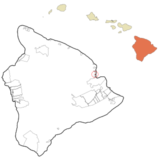
Paukaʻa is a census-designated place (CDP) in Hawaii County, Hawaii, United States. The population was 425 at the 2010 census, down from 495 at the 2000 census. The ZIP code is 96720.

Forest Lake is an unincorporated community and census-designated place (CDP) in Ela Township of Lake County, Illinois, United States. It is about 35 miles (56 km) northwest of downtown Chicago. Per the 2020 census, the population was 1,784. The community was founded in 1935 as a vacation community for Chicago residents.

Fox Lake Hills is an unincorporated community and census-designated place (CDP) in Lake Villa Township, Lake County, Illinois, United States. Per the 2020 census, the population was 2,684.

Lake Catherine is an unincorporated community and census-designated place (CDP) in Lake County, Illinois, United States. Per the 2020 census, the population was 1,279.

Long Lake is an unincorporated community and census-designated place (CDP) in Lake County, Illinois, United States. Per the 2020 census, the population was 3,663.

Venetian Village is a census-designated place (CDP) in Lake County, Illinois, United States. Per the 2020 census, the population was 2,761.

<span class="mw-page-title-main">Canada Creek Ranch, Michigan</span> Census-designated place in Michigan, United States

Canada Creek Ranch is an unincorporated community in Montmorency Township, Montmorency County, in the U.S. state of Michigan. It is a census-designated place (CDP) used for statistical purposes. The population was 258 at the 2020 census, down from 304 in 2010.

<span class="mw-page-title-main">Laurel Lake, New Jersey</span> Populated place in Cumberland County, New Jersey, US

Laurel Lake is an unincorporated community and census-designated place (CDP) located within Commercial Township, in Cumberland County, in the U.S. state of New Jersey. It is part of the Vineland-Millville-Bridgeton Primary Metropolitan Statistical Area for statistical purposes. As of the 2010 United States Census, the CDP's population was 2,989.

<span class="mw-page-title-main">Twin Lakes, New Mexico</span> CDP in New Mexico, United States

Twin Lakes is a census-designated place (CDP) in McKinley County, New Mexico, United States. The population was 1,069 at the 2000 census.

<span class="mw-page-title-main">Angola on the Lake, New York</span> Census-designated place in New York, United States

Angola on the Lake is a hamlet and census-designated place (CDP) in Erie County, New York, United States. The population was 1,675 at the 2010 census. It is part of the Buffalo–Niagara Falls Metropolitan Statistical Area.

<span class="mw-page-title-main">Duane Lake, New York</span> Census-designated place in New York, United States

Duane Lake is a census-designated place (CDP) in Schenectady County, New York, United States. The population was 323 at the 2010 census.

<span class="mw-page-title-main">Quiogue, New York</span> Hamlet and census-designated place in New York, United States

Quiogue is a hamlet and census-designated place (CDP) in the Town of Southampton, in Suffolk County, New York, United States. The population was 816 at the 2010 census. The name of the CDP was corrected from "Quioque" to "Quiogue" by the U.S. Census Bureau in 2010.

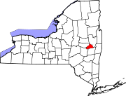
Northeast Ithaca is a census-designated place (CDP) in Ithaca (town), New York in Tompkins County, New York, United States. The population was 2,655 at the 2000 census.

<span class="mw-page-title-main">South Hill, New York</span> CDP in New York, United States

South Hill is a census-designated place (CDP) in Tompkins County, New York, United States. The population was 7,245 at the 2020 census.

<span class="mw-page-title-main">Martha Lake, Washington</span> CDP in Washington, United States

Martha Lake is a census-designated place (CDP) in Snohomish County, Washington, United States. The population was 21,129 at the 2020 census. It lies west of Mill Creek and northeast of Lynnwood, near the lake of the same name.

<span class="mw-page-title-main">Little Round Lake, Wisconsin</span> CDP in Wisconsin, United States

Little Round Lake is a census-designated place (CDP) in the town of Bass Lake, Sawyer County, Wisconsin, United States. The population was 1,081 at the 2010 census. It is the largest community on the reservation of the federally recognized tribe of the Lac Courte Oreilles Band of Lake Superior Chippewa Indians.

<span class="mw-page-title-main">Lake Wazeecha, Wisconsin</span> CDP in Wisconsin, United States

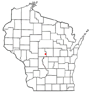
Lake Wazeecha is a census-designated place (CDP) in the town of Grand Rapids, Wood County, Wisconsin, United States. The population was 2,651 at the 2010 census.

References

  1. "ArcGIS REST Services Directory". United States Census Bureau. Retrieved September 20, 2022.
  2. "Profile of General Population and Housing Characteristics: 2010 Demographic Profile Data (DP-1): Mariaville Lake CDP, New York". United States Census Bureau . Retrieved July 5, 2012.
  3. US Census Bureau, 2020 Census Results, Mariaville Lake CDP, New York https://www.census.gov/search-results.html?searchType=web&cssp=SERP&q=Mariaville%20Lake%20CDP,%20New%20York
  4. "US Gazetteer files: 2010, 2000, and 1990". United States Census Bureau. February 12, 2011. Retrieved April 23, 2011.
  5. "Census of Population and Housing". Census.gov. Retrieved June 4, 2016.
  6. "U.S. Census website". United States Census Bureau . Retrieved January 31, 2008.