Marine Corps Air Station Tustin

Last updated

Marine Corps Air Station Tustin
Tustin, California
Tustin Blimp Hangar No 2.jpg
Hangar No. 2 (South Hangar) at the former Marine Corps Air Station in Tustin, California measures 1,072 feet (327 m) long by 292 feet (89 m) wide by 192 feet (59 m) tall. It and its sister structure (partially visible to the right) are listed on the National Register of Historic Places and designated a National Historic Civil Engineering Landmark. The two hangars, built in 1942 of Oregon Douglas fir, are among the largest free-standing wooden structures in the world. Hangar No. 1 (North Hangar) was destroyed by fire in November, 2023. [1]
Coordinates 33°42′25″N117°49′31″W / 33.70685°N 117.825217°W / 33.70685; -117.825217
TypeMilitary base
Site information
Controlled by United States Marine Corps
Site history
Builtcommencing 1 April 1942
In use7 October 1942 – 2 July 1999

Marine Corps Air Station Tustin (IATA: NTK, ICAO: KNTK, FAA LID: NTK) is a former United States Navy and United States Marine Corps air station, located in Tustin, California.

Contents

History

The Air Station was established in 1942 by the United States Navy as a lighter-than-air base, officially known as Naval Air Station Santa Ana. [2] The base was designed for blimp operations in support of the Navy's coastal patrol efforts during World War II. It was commissioned on 1 October 1942 by its commandant, Capt. Howard N. Coulter. [3] As of July 1947, the facility, under command of Capt. Benjamin May, had personnel consisting of 100 officers, 500 enlisted men and 180 civilian employees. [4] NAS Santa Ana was decommissioned in 1949. In 1951, the facility was reactivated as Marine Corps Air Facility Santa Ana [2] to support the Korean War. It was the country's first air facility developed solely for helicopter operations. It was named "Marine Corps Air Station, Santa Ana" in 1966 and renamed Marine Corps Air Station Tustin in 1979.

During the Vietnam War, the base was a center for on-going testing of radar installations (including the Sperry TPS-34) which were erected, tested, disassembled and shipped to South Vietnam. It also was a training facility for helicopter pilots.

By the early 1990s, MCAS Tustin was a major center for Marine Corps helicopter aviation and radar on the Pacific Coast. Its primary purpose was to provide support services and material for the 3rd Marine Aircraft Wing and for other units utilizing the base. About 4,500 residents once lived on the base, and the base employed nearly 5,000 military personnel and civilians. In addition to providing military support, MCAS Tustin leased 530 acres (2.1 km2) to farmers for commercial crop development. For many years, agricultural lands surrounded the facility. However beginning in the 1980s residential and light industrial/manufacturing areas developed adjacent to the station.

In 1991 and again in 1993, under the authority of the Base Realignment and Closure Act of 1990, it was announced that MCAS Tustin would be closed. Operational closure of the base occurred in July 1999. Of the approximately 1,600 acres (650 ha), some 1,294 acres (524 ha) (now known collectively as "Tustin Legacy") have been conveyed to the City of Tustin, private developers and public institutions for a combination of residential, commercial, educational, and public recreational and open-space uses. The remaining 300-plus acres (120 ha) will be conveyed to other federal agencies, the City of Tustin, and public institutions for the same uses once environmental clean-up operations have been concluded. The site of the base is now the home of the academy of the Orange County Sheriff's Department. Much of the former base has become residential housing.

The base was featured in Visiting... with Huell Howser Episode 1509. [5]

Blimp hangars

In 1993, the blimp hangars were designated a National Civil Engineering Landmark by the American Society of Civil Engineers (ASCE). [6] Worldwide Aeros Corp utilized the north hangar to build a prototype cargo airship under contract from the Pentagon and NASA. [7] In October, 2013, part of the roof collapsed, damaging the airship prototype. [8] There was interest in making one of the hangars a military museum. [9]

The blimp hangars have been used for location shooting for numerous movies and TV programs, including JAG and The X-Files . [2] [10]

Tustin Hangar No. 1 fire, 11:48 am 7 November 2023 Tustin Hangar No. 1 Fire, 11-48 am on 11.07.2023.jpg
Tustin Hangar No. 1 fire, 11:48 am 7 November 2023

On 7 November 2023 at approximately 12:53am, a three-alarm fire broke out on the roof of the North Hangar. Orange County Fire Authority units responded, adapting a defensive strategy and letting it burn due to the risk of roof collapse. An investigation has been opened into the cause of the fire. [11] [12] Several schools in Tustin Unified School District were temporarily closed when asbestos was detected near the fire on 9 November. [13] Tustin authorities plan to demolish the remainder of the hangar, [14] and demolition commenced in December. [15] The hangar site is to be completely remediated by the U.S. Navy. [16] [17]

Proposals

Plans are in the works to convert 84.5 acres (34.2 ha) of the former base into a regional park, originally scheduled to be opened in 2016. [1] In the summer of 2013, OC Parks was in the process of gathering input from the community in order to determine the features and layout of the forthcoming facilities.

Although the preservation of the hangars is one of the greatest concerns raised in surveys taken by OC Parks, the fate of the south hangar is uncertain.

The City of Tustin has met with officials from the Los Angeles Angels of Anaheim, proposing the former air base as a potential site for a new stadium for the team, whose lease with the City of Anaheim's Angel Stadium allowed the team to opt out between 2016 and 2019. [18]

In 2016, Orange County and the South Orange County Community College District arranged for a land swap of ten acres to be used to replace the aging Orange County Animal Shelter in nearby Orange. In July 2016, a ground-breaking ceremony was held. [19]

See also

Related Research Articles

<span class="mw-page-title-main">Tustin, California</span> City in Orange County, California, US

Tustin is a city located in Orange County, California, United States, within the Los Angeles metropolitan area. In 2020, Tustin had a population of 80,276. The city does not include the unincorporated community of North Tustin.

<span class="mw-page-title-main">Moffett Federal Airfield</span> Joint civil-military airport in California

Moffett Federal Airfield, also known as Moffett Field, is a joint civil-military airport located in an unincorporated part of Santa Clara County, California, United States, between northern Mountain View and northern Sunnyvale. On November 10, 2014, NASA announced that it would be leasing 1,000 acres (400 ha) of the airfield property to Google for 60 years.

<span class="mw-page-title-main">Marine Corps Air Station El Toro</span> Airport in Orange County, California

Marine Corps Air Station El Toro was a United States Marine Corps Air Station located next to the community of El Toro, near Irvine, California.

<span class="mw-page-title-main">Orange County Great Park</span> Public park in Irvine, California

The Great Park is a public park located in Irvine, California, with a focus on sports, agriculture, and the arts. It is a non-aviation reuse of the decommissioned Marine Corps Air Station (MCAS) El Toro. The Orange County park comprises 28.8% of the total area that once made up the air base. The project was approved by the voters of Orange County in 2002 at $1.1 billion.

<span class="mw-page-title-main">Marine Corps Air Station Miramar</span> USMC installation that is home to the 3rd Marine Aircraft Wing

Marine Corps Air Station Miramar, formerly Naval Auxiliary Air Station (NAAS) Miramar and Naval Air Station (NAS) Miramar, is a United States Marine Corps installation that is home to the 3rd Marine Aircraft Wing, which is the aviation element of the 1st Marine Expeditionary Force. It is located in Miramar, San Diego, California, about 14 miles (23 km) north of Downtown San Diego.

<span class="mw-page-title-main">Hangar</span> Closed structure to hold aircraft or spacecraft in protective storage

A hangar is a building or structure designed to hold aircraft or spacecraft. Hangars are built of metal, wood, or concrete. The word hangar comes from Middle French hanghart, of Germanic origin, from Frankish *haimgard, from *haim and gard ("yard"). The term, gard, comes from the Old Norse garðr.

<span class="mw-page-title-main">HMH-361</span> Military unit

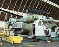
Marine Heavy Helicopter Squadron 361 (HMH-361) is a United States Marine Corps helicopter squadron consisting of CH-53E Super Stallion transport helicopters. The squadron, known as the "Flying Tigers", is based at Marine Corps Air Station Miramar, California and falls under the command of Marine Aircraft Group 16 (MAG-16) and the 3rd Marine Aircraft Wing.

<span class="mw-page-title-main">HMH-462</span> Military unit

Marine Heavy Helicopter Squadron 462 (HMH-462) is a United States Marine Corps helicopter squadron operating CH-53E Super Stallion heavy transport helicopters. The squadron, known as the "Heavy Haulers", is based at Marine Corps Air Station Miramar, California and falls under the command of Marine Aircraft Group 16 (MAG-16) and the 3rd Marine Aircraft Wing.

<span class="mw-page-title-main">VMM-164</span> Military unit

Marine Medium Tiltrotor Squadron 164 (VMM-164), is a United States Marine Corps tiltrotor squadron operating the MV-22B Osprey. Known as the Knightriders, they fall under the command Marine Aircraft Group 39 (MAG-39) and the 3rd Marine Aircraft Wing. They are based at Marine Corps Air Station Camp Pendleton.

<span class="mw-page-title-main">Marine Aviation Logistics Squadron 16</span> Military unit

Marine Aviation Logistics Squadron 16 (MALS-16) is an aviation logistics support unit of the United States Marine Corps. Known as the Immortals, they are currently based at Marine Corps Air Station Miramar and fall under the command of Marine Aircraft Group 16 (MAG-16) and the 3rd Marine Aircraft Wing.

<span class="mw-page-title-main">Santa Ana Army Air Base</span> Former military base in Orange County, California

Santa Ana Army Air Base (SAAAB) was a World War II-era air base located near Santa Ana, California. The air base was decommissioned in 1946, and part of the land was annexed by Costa Mesa in 1953. The air base was used for basic training, although it did not have planes, hangars or runways. The base was 1,336 acres (5.41 km2), and the main section of the base was located between Baker Street to the north, Harbor Boulevard to the west, Wilson Street on the south, and Newport Boulevard on the east. The land formerly occupied by the air base is today the home of John Wayne Airport, the Orange County Fairgrounds, and Orange Coast College.

<span class="mw-page-title-main">Camp Kearny</span>

Camp Kearny was a U.S. military base in San Diego County, California, on the site of the current Marine Corps Air Station Miramar. It operated from 1917 to 1946. The base was named in honor of Brigadier General Stephen W. Kearny.

<span class="mw-page-title-main">Modjeska Peak</span> Stream in the American state of California

Modjeska Peak is the northern mountain of the Saddleback landform in Orange County California. It is the second-highest peak of the Santa Ana Mountains, after Santiago Peak, whose summit is less than 0.6 mi (0.97 km) to the northwest. Modjeska lies within Cleveland National Forest and, despite being shorter than Santiago, has a smaller peak without manmade structures to obstruct views of the Pacific Ocean and San Gabriel Mountains.

<span class="mw-page-title-main">Naval Air Station South Weymouth</span> Airport in and Abington, Massachusetts

Naval Air Station South Weymouth was an operational United States Navy airfield from 1942 to 1997 in South Weymouth, Massachusetts. It was first established as a regular Navy blimp base during World War II. During the postwar era the base became part of the Naval Air Reserve Training Command, hosting a variety of Navy and Marine Corps reserve aircraft squadrons and other types of reserve units. Like most BRAC sites, environmental contamination was detected in 1986, and since 1993 numerous remedies and long term monitoring of ground water are in place. Since 2005, over 600 acres have been transferred to the affected towns for reuse, and in 2011 the Navy signed a $25 million contract to transfer its remaining land.

Aeros Corp is an American manufacturer of airships based in Los Angeles, California. It was founded in 1993 by the current CEO and Chief Engineer, Igor Pasternak, who was born in Soviet Kazakhstan, raised in Soviet Ukraine, and moved to the U.S. after the Soviet collapse to build airships there. It currently employs more than 100 workers.

<span class="mw-page-title-main">Hangar One (Moffett Federal Airfield)</span> United States historic place

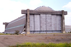
Hangar One is one of the world's largest freestanding structures, covering 8 acres at Moffett Field near Mountain View, California in the San Francisco Bay Area.

The Weeksville Dirigible Hangar is an airship manufacturing, storage and test facility originally built by the United States Navy in 1941 for servicing airships conducting anti-submarine patrols of the US coast and harbors. It is located on the former Naval Air Station Weeksville in Elizabeth City, North Carolina, approximately 2 miles southeast of the present day Coast Guard Air Station Elizabeth City.

The U.S. Naval Air Station, Sunnyvale Historic District, also known as Shenandoah Plaza, is a historic district located on 62.48 acres (25.3 ha) at Moffett Field, California.

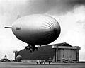
In the nation's quest to provide security along its lengthy coastlines, air reconnaissance was put forth by the futuristic Rear Admiral William A. Moffett. Through his efforts, two Naval Air Stations were commissioned in the early 1930s to port the Naval Airships (dirigibles) which he believed capable of meeting this challenge.

<span class="mw-page-title-main">Naval Air Station Los Alamitos Naval Outlying Landing Fields</span> 1940s US Navy runways in California

Naval Air Station Los Alamitos Naval Outlying Landing Fields were a set airfield near Naval Air Station Los Alamitos to support the training of US Navy pilots during World War 2. The support airfields are called Naval Outlying Landing Field (NOLF). For the war, many new trained pilots were needed. The Naval Outlying Landing Fields provided a place for pilots to practice landing and take off without other air traffic. The remotes sites offered flight training without distractions. Most of the new pilots departed to the Pacific War after training. The Outlying Landing Fields had little or no support facilities. Naval Air Station Los Alamitos opened in 1942 and was transferred to the US Army in 1977 as Los Alamitos Army Airfield. Most of the Outlying fields closed in 1945, having completed the role of training new pilots. To open the needed Outlying Landing Fields quickly, the Navy took over local crop dusting and barnstorming airfields. Naval Air Station Los Alamitos was also called Los Alamitos Naval Reserve Air Base. During the war Marine Corps Air Station El Toro also used the outlying Landing Field. The Timm N2T Tutor was the most common plane used for training on the outlying landing fields.

References

  1. 1 2 "Regional Park at Former MCAS Tustin" . Retrieved 23 May 2013.
  2. 1 2 3 Paul Freeman (8 February 2016). "Historic California Posts: Marine Corps Air Station, Tustin". California Military History Online. Retrieved 3 April 2021.
  3. Associated Press, "Dirigible Base Is Opened at Santa Ana", The San Bernardino Daily Sun, San Bernardino, California, Friday 2 October 1942, Volume 49, page 1.
  4. Associated Press, "Santa Ana to Lose Naval Air Station", The San Bernardino Daily Sun, San Bernardino, California, Monday 28 July 1947, Volume 53, page 2.
  5. "Tustin – Visiting (1509) – Huell Howser Archives at Chapman University".
  6. Fry, Hannah; Petri, Alexandra E. (7 November 2023). "Cavernous WWII-era hangar burns in Tustin, destroying a relic of Orange County's military past". Los Angeles Times. Retrieved 8 November 2023.
  7. W. J. Henningan (4 January 2013). "Construction is complete on behemoth airship; first flight planned". Los Angeles Times. Retrieved 7 January 2013.
  8. Flores, Adolfo; Bartletti, Don (7 October 2013). "WWII-era blimp hangar's partial collapse triggers helium leak". Los Angeles Times . Retrieved 20 March 2018.
  9. McKibben, Dave (3 January 2002). "Veterans Group Hopes to Convert Tustin Hangar Into an Interactive War Museum". Los Angeles Times. Retrieved 9 November 2023.
  10. Valdez, Jonah (8 November 2023). "Tustin hangar fire: Air base was a major Hollywood player in 'Star Trek,' 'Pearl Harbor' and more". Los Angeles Times. Retrieved 8 November 2023.
  11. Flores, Adolfo; Bartletti, Don (7 November 2023). "WWII-era blimp hangar's partial collapse triggers helium leak". The Guardian . Retrieved 7 November 2023.
  12. Lloyd, Jonathan (7 November 2023). "Fire burns former Tustin Air Base hangar, part of Orange County's military history". NBC Los Angeles. Retrieved 7 November 2023.
  13. "Tustin public schools closed after asbestos detected in historic hangar fire debris". ABC7 Los Angeles. 9 November 2023. Retrieved 18 November 2023.
  14. Arellano, Gustavo (15 November 2023). "Column: O.C. let its history rot. And the Tustin hangar fire is still burning". Los Angeles Times. Retrieved 18 November 2023.
  15. "The Tustin Hangar fire is out and deconstruction has begun". New Santa Ana. 6 December 2023. Retrieved 8 December 2023.
  16. "Tustin Hangar Fire: Community Update". City of Irvine. 12 November 2023. Retrieved 8 December 2023.
  17. Warner, Gary (14 May 2024). "Navy cost for fire at shuttered California blimp hangar could surpass $100M". Stars and Stripes. Retrieved 17 May 2024.
  18. DiGiovanna, Mike (15 February 2014). "Angels owner Arte Moreno meets with Tustin officials to talk stadium". Los Angeles Times. Retrieved 19 February 2014.
  19. Nissen, Dano (1 August 2016). "$35 Million Animal Shelter Replaces Tustin Marine Base". KNBC. NBC. Retrieved 2 August 2016.

Further reading

33°42′24″N117°49′18″W / 33.706777°N 117.821674°W / 33.706777; -117.821674