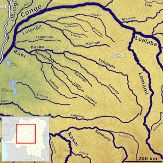
The Lulonga is a river in the Equateur province of Democratic Republic of the Congo. It is about 200 km long from its beginning at the town of Basankusu. The Lopori and the Maringa join to form the Lulonga there. The Lulonga River flows into the Congo River at the village of Lulonga.

Basankusu is a town in Équateur Province, Democratic Republic of the Congo. It is the main town and administrative centre of the Basankusu Territory. In 2004, it had an estimated population of 23,764. It has a gravel airstrip, covered and open markets, a hospital, and three cellphone networks, the first of which was installed in 2006. The town is also known as a centre for bonobo conservation efforts. Despite such developments, most inhabitants live at a subsistence level: hunting, fishing, keeping chickens and keeping a vegetable plot. In 2010, the workers at the local palm plantation would earn an average monthly salary of $40, most others would have much less.

John Thomas North was an English investor and businessman. North was born in Leeds, Yorkshire, the son of a coal merchant and a churchwarden. At the age of fifteen he was apprenticed to millwrights and engineers before working for several years as a mechanic. He moved to Chile where his first occupation was as a boiler riveter in Huasco. He later moved to the Chilean town of Iquique where he worked as a waterworks operator, importer and ship owner. The War of the Pacific (1879–1883) provided North with an opportunity to purchase large numbers of bonds in the Peruvian nitrate industry. When Chile annexed Iquique and the surrounding province of Tarapacá the Chilean government transferred ownership of the nitrate fields to the bondholders. North was thus able to take a monopoly share of the lucrative Chilean nitrate industry for a very small initial investment, becoming known as "The Nitrate King".
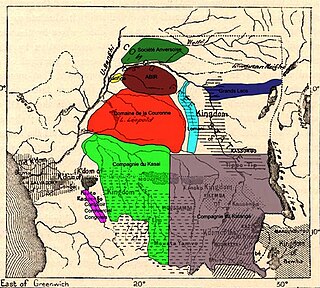
The Société Anversoise was a concession company of the Congo Free State, headquartered in Antwerp. It was, with the Lulonga Company and the Abir Congo Company, one of the main producers of rubber in the Free State. Alongside Abir and the Lulonga Company the Société Anversoise handed back control of the concession to the Congo Free State in 1906. The Société Anversoise merged with Abir in 1911 to form the Compagnie du Congo Belge with a focus of the management of rubber plantations instead of the harvesting of naturally occurring rubber. The Société Anversoise was quoted on the Antwerp Stock Exchange from 27 July 1898.
The Lulonga Company was a concession company of the Congo Free State. It was, with the Société Anversoise and the Abir Congo Company, one of the main producers of rubber in the Free State. The company's rubber production declined in the early 20th century as a result of over harvesting of the natural rubber vine and the entire concession produced just seven tons of rubber in 1905. Like Abir and the Société Anversoise, the Lulonga Company handed back control of the concession to the Congo Free State in 1906.

The Abir Congo Company was a company that exploited natural rubber in the Congo Free State, the private property of King Leopold II of Belgium. The company was founded with British and Belgian capital and was based in Belgium. By 1898 there were no longer any British shareholders and the Anglo-Belgian India Rubber Company changed its name to the Abir Congo Company and changed its residence for tax purposes to the Free State. The company was granted a large concession in the north of the country and the rights to tax the inhabitants. This tax was taken in the form of rubber obtained from a relatively rare rubber vine. The collection system revolved around a series of trade posts along the two main rivers in the concession. Each post was commanded by a European agent and manned with armed sentries to enforce taxation and punish any rebels.
Wamba is a village in the Luo Scientific Reserve, Tshuapa province of the Democratic Republic of the Congo. It is inhabited by Bongando people. The reserve is home to bonobos, threatened due to hunting.

The Bonobo Conservation Initiative is a non-profit organization based in Washington, D.C. and the Democratic Republic of the Congo that promotes conservation of the bonobo and its habitat in the tropical forests of the Congo Basin.
The Lopori river is a river in the Democratic Republic of the Congo. The Lopori, and the Maringa River to the south, join near Basankusu to form the Lulonga River, a tributary of the Congo River. The Lopori / Maringa basin is called the Maringa-Lopori-Wamba forest Landscape, an area of great ecological importance.
The Maringa river is a river in the Democratic Republic of the Congo. The Maringa, and the Lopori River to the north, join near Basankusu to form the Lulonga River, a tributary of the Congo River. The Maringa / Lopori basin contains the Maringa-Lopori-Wamba Landscape, an area of great ecological importance. The Ngando people live in the Maringa River area north of Ikela.
The Ngando people are Bantu subsistence farmers who live in eastern part of Équateur and the western part of Orientale province in the Democratic Republic of the Congo.
The African Wildlife Foundation (AWF) is an international conservation organization dedicated to the preservation of Africa's wildlife and wild lands. AWF aims to protect the continent's wild lands as well as its wildlife and natural resources.

The Bolombo River is a river in Équateur province, Democratic Republic of the Congo. The Bolombo is a tributary of the Lopori River. The Lopori River joins with the Maringa River to the south, to form the Lulonga River, a tributary of the Congo River. The Bolombo flows through the Lopori / Maringa basin, also known as the Maringa-Lopori-Wamba forest Landscape, an area of great ecological importance.
The Yekokora River is a river in Équateur province, Democratic Republic of the Congo. The Yekokora is a tributary of the Lopori River. The Lopori River joins with the Maringa River to the south, to form the Lulonga River, a tributary of the Congo River. The Yekokora flows through the Lopori / Maringa basin, also known as the Maringa-Lopori-Wamba forest Landscape, an area of great ecological importance.
The Lomako River is a river in Équateur province, Democratic Republic of the Congo. The Lomako is a tributary of the Maringa River. The Maringa River joins with the Lopori River to the north, to form the Lulonga River, a tributary of the Congo River. The Lomako flows through the Lopori / Maringa basin, also known as the Maringa-Lopori-Wamba Landscape, an area of great ecological importance.
Alice, Lady Harris was an English missionary and an early documentary photographer. Her photography helped to expose the human rights abuses in the Congo Free State under the regime of King Leopold II of the Belgians.

From 1885 to 1908, many atrocities were committed in the Congo Free State under the absolute rule of King Leopold II of Belgium. These atrocities were particularly associated with the labour policies, enforced by colonial administrators, used to collect natural rubber for export. Combined with epidemic disease, famine, and falling birth rates caused by these disruptions, the atrocities contributed to a sharp decline in the Congolese population. The magnitude of the population fall over the period is disputed, with modern estimates ranging from 1.5 million to 13 million.

Ernest Baert was a Belgian soldier, explorer and colonial administrator who was active in the Congo Free State.
The Kokolopori Bonobo Reserve is a nature reserve in the Democratic Republic of the Congo. The 4,875-square-kilometre (1,882 sq mi) reserve is a protected area for endangered bonobos and uses a community-based model of natural resource management undertaken by residents of the villages of Kokolopori and the local conservation organisation Vie Sauvage.


