Marshfield, Missouri | |
---|---|
City of Marshfield | |
Coordinates: 37°20′23″N92°54′26″W / 37.33972°N 92.90722°W | |
Country | United States |
State | Missouri |
County | Webster |
Founded | 1855 |
Incorporated | 1856 |
Named for | Marshfield, Massachusetts |
Government | |
• Mayor | Natalie McNish |
• City Administrator | Sam Rost |
Area | |
• Total | 5.53 sq mi (14.33 km2) |
• Land | 5.52 sq mi (14.30 km2) |
• Water | 0.01 sq mi (0.03 km2) |
Elevation | 1,493 ft (455 m) |
Population (2020) | |
• Total | 7,458 |
• Density | 1,350.84/sq mi (521.60/km2) |
Time zone | UTC-6 (Central (CST)) |
• Summer (DST) | UTC-5 (CDT) |
ZIP code | 65706 |
Area code | 417 |
FIPS code | 29-46388 [2] |
GNIS feature ID | 0721909 [3] |
Website | marshfieldmo.gov |
Marshfield is a city in Missouri and the county seat of Webster County, Missouri. As of the 2010 census, the city population was 6,633. [4] As of the 2020 census, Marshfield had a population of 7,458. It is part of the Springfield, Missouri, metropolitan area. [5]
Marshfield was platted in 1855, taking its name from Marshfield, Massachusetts. [6] A post office called Marshfield has been in operation since 1856. [7] Marshfield is the county seat of Webster County and sits on land donated by William T. Burford and C.F. Dryden. [8]
The Hosmer Dairy Farm Historic District and Rainey Funeral Home Building are listed on the National Register of Historic Places. [9] [10]
Marshfield is home to the only intersection of the TransAmerica Bicycle Trail and U.S. Route 66. [11]
Marshfield is the hometown of Edwin Hubble. A replica of the Hubble Space Telescope can be found in front of the Webster County Court House at 100 S Clay St.
Marshfield is located at 37°20′23″N92°54′26″W / 37.33972°N 92.90722°W (37.339599, -92.907230). [12] According to the United States Census Bureau, the city has a total area of 5.03 square miles (13.03 km2), all land. [13]
Marshfield has a humid subtropical climate (Köppen climate classification Cfa), with elements of a humid continental climate. The city experiences four distinct seasons; summers are warm and humid, while winters are cool with occasional cold spells. Rainfall is highest in the late spring. Snowfall is generally light, with an average of 5.2 inches (13 cm).
Climate data for Marshfield, Missouri (1991–2020 normals, extremes 1908–present) | |||||||||||||
---|---|---|---|---|---|---|---|---|---|---|---|---|---|
Month | Jan | Feb | Mar | Apr | May | Jun | Jul | Aug | Sep | Oct | Nov | Dec | Year |
Record high °F (°C) | 76 (24) | 82 (28) | 88 (31) | 91 (33) | 95 (35) | 102 (39) | 110 (43) | 104 (40) | 102 (39) | 93 (34) | 84 (29) | 75 (24) | 110 (43) |
Mean daily maximum °F (°C) | 42.2 (5.7) | 47.3 (8.5) | 57.0 (13.9) | 67.3 (19.6) | 75.4 (24.1) | 83.6 (28.7) | 87.9 (31.1) | 87.2 (30.7) | 79.9 (26.6) | 68.6 (20.3) | 55.8 (13.2) | 45.6 (7.6) | 66.5 (19.2) |
Daily mean °F (°C) | 31.9 (−0.1) | 36.3 (2.4) | 45.5 (7.5) | 55.5 (13.1) | 64.6 (18.1) | 73.1 (22.8) | 77.5 (25.3) | 76.4 (24.7) | 68.7 (20.4) | 57.3 (14.1) | 45.1 (7.3) | 35.8 (2.1) | 55.6 (13.1) |
Mean daily minimum °F (°C) | 21.5 (−5.8) | 25.2 (−3.8) | 34.0 (1.1) | 43.7 (6.5) | 53.9 (12.2) | 62.7 (17.1) | 67.0 (19.4) | 65.6 (18.7) | 57.5 (14.2) | 46.0 (7.8) | 34.4 (1.3) | 26.0 (−3.3) | 44.8 (7.1) |
Record low °F (°C) | −20 (−29) | −17 (−27) | −7 (−22) | 19 (−7) | 29 (−2) | 41 (5) | 47 (8) | 45 (7) | 31 (−1) | 18 (−8) | 3 (−16) | −18 (−28) | −20 (−29) |
Average precipitation inches (mm) | 2.65 (67) | 2.47 (63) | 3.73 (95) | 4.72 (120) | 5.54 (141) | 4.64 (118) | 4.45 (113) | 3.35 (85) | 4.15 (105) | 3.50 (89) | 3.64 (92) | 2.81 (71) | 45.65 (1,160) |
Average snowfall inches (cm) | 1.7 (4.3) | 0.6 (1.5) | 0.6 (1.5) | 0.0 (0.0) | 0.0 (0.0) | 0.0 (0.0) | 0.0 (0.0) | 0.0 (0.0) | 0.0 (0.0) | 0.0 (0.0) | 0.1 (0.25) | 2.2 (5.6) | 5.2 (13) |
Average precipitation days (≥ 0.01 in) | 7.9 | 7.4 | 10.3 | 10.7 | 12.5 | 10.3 | 9.6 | 8.9 | 8.1 | 8.7 | 8.5 | 7.4 | 110.3 |
Average snowy days (≥ 0.1 in) | 1.2 | 1.1 | 0.2 | 0.0 | 0.0 | 0.0 | 0.0 | 0.0 | 0.0 | 0.0 | 0.1 | 0.7 | 3.3 |
Source: NOAA [14] [15] |
Census | Pop. | Note | %± |
---|---|---|---|
1860 | 408 | — | |
1870 | 809 | 98.3% | |
1880 | 655 | −19.0% | |
1890 | 980 | 49.6% | |
1900 | 964 | −1.6% | |
1910 | 1,193 | 23.8% | |
1920 | 1,371 | 14.9% | |
1930 | 1,378 | 0.5% | |
1940 | 1,764 | 28.0% | |
1950 | 1,925 | 9.1% | |
1960 | 2,221 | 15.4% | |
1970 | 2,961 | 33.3% | |
1980 | 3,871 | 30.7% | |
1990 | 4,374 | 13.0% | |
2000 | 5,720 | 30.8% | |
2010 | 6,633 | 16.0% | |
2020 | 7,458 | 12.4% | |
U.S. Decennial Census |
At the 2010 census, 6,633 people, 2,605 households, and 1,756 families were living in the city. The population density was 1,318.7 inhabitants per square mile (509.2/km2). The 2,918 housing units had an average density of 580.1 per square mile (224.0/km2). The racial makeup of the city was 96.5% White, 0.4% African American, 0.8% Native American, 0.2% Asian, 0.5% from other races, and 1.7% from two or more races. Hispanics or Latinos of any race were 1.7%. [16]
Of the 2,605 households, 37.0% had children under 18 living with them, 49.0% were married couples living together, 14.0% had a female householder with no husband present, 4.4% had a male householder with no wife present, and 32.6% were not families. About 28.9% of households were one person, and 14.8% were one person 65 or older. The average household size was 2.47, and the average family size was 3.04.
The median age was 36.4 years. The city's age distribution was 27.6% under 18, 8.5% between 18 and 24; 24.3% from 25 to 44; 21.9% from 45 to 64; and 17.7% 65 or older. The gender makeup of the city was 47.1% male and 52.9% female.
At the 2000 census, 5,720 people, 2,256 households, and 1,534 families resided in the city. The population density was 1,182.7 inhabitants per square mile (456.6/km2). The 2,417 housing units had an average density of 499.8 per square mile (193.0/km2). The racial makeup of the city was 97.80% White, 0.19% African American, 0.42% Native American, 0.30% Asian, 0.12% from other races, and 1.17% from two or more races. Hispanics or Latinos of any race were 1.75%. [2]
Of the 2,256 households. 34.7% had children under 18 living with them, 53.2% were married couples living together, 11.4% had a female householder with no husband present, and 32.0% were not families. About 28.7% of households were one person, and 16.0% were one person 65 or older. The average household size was 2.44, and the average family size was 3.00.
The age distribution was 27.1% under 18, 9.4% from 18 to 24, 27.2% from 25 to 44, 18.2% from 45 to 64, and 18.1% 65 or older. The median age was 35 years. For every 100 females, there were 85.0 males. For every 100 females age 18 and over, there were 79.3 males.
As of 2000, The median household income was $27,753, and the median family income was $36,090. Males had a median income of $27,813 versus $20,752 for females. The per capita income for the city was $14,855. About 5.5% of families and 11.6% of the population were below the poverty line, including 10.2% of those under age 18 and 12.2% of those age 65 or over.
Marshfield has one public high school, Marshfield High School. Marshfield Christian School is a private institution.
Marshfield has a lending library, which is a branch of the Webster County Library. [17]
As of June 2021, the mayor of Marshfield is Natalie B. McNish and the city administrator is Sam Rost. [18] [19]
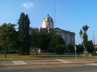
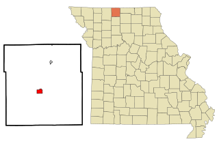
Webster County is a county located in the U.S. state of Missouri. As of the 2020 census, the population was 39,085. Its county seat is Marshfield. The county was organized in 1855 and named for U.S. Senator and U.S. Secretary of State Daniel Webster.
Lansing is a city in Leavenworth County, Kansas, United States. It is situated along the west side of the Missouri River and Kansas-Missouri state border. As of the 2020 census, the population of the city was 11,239. It is the second most populous city of Leavenworth County and is a part of the Kansas City metropolitan area. The Lansing Correctional Facility, which includes the state's main maximum-security prison, is located in Lansing.
Jackson is a city in and the county seat of Cape Girardeau County, Missouri, United States. It is a principal city of the Cape Girardeau–Jackson, MO-IL Metropolitan Statistical Area. The population of Jackson was 15,481 at the 2020 census.
Smithville is a city in Clay and Platte counties in the U.S. state of Missouri and is part of the Kansas City metropolitan area, along the Little Platte River. The population was 10,406 at the 2020 United States Census.
Lebanon is a city in and the county seat of Laclede County in Missouri. The population was 14,474 at the time of the 2010 census. It is the county seat of Laclede County. The Lebanon Micropolitan Statistical Area consists of Laclede County.
Princeton is the county seat and largest city of Mercer County, Missouri, United States. The population was 1,007 at the 2020 census, down from the 2010 census, which counted 1,166 people. Princeton was the birthplace of the famous frontierswoman Calamity Jane.
Paris is a city and county seat of Monroe County, Missouri, United States. The population was 1,161 at the 2020 census.
Laurie is a city in southern Morgan and northern Camden counties, Missouri, United States. The population was 939 at the 2020 census.
Linn is a city in Osage County, Missouri, United States. The population was 1,350 at the 2020 census. It is the county seat of Osage County. Linn is part of the Jefferson City, Missouri Metropolitan Statistical Area.
Fordland is a city in southern Webster County, Missouri, United States. The population was 800 at the 2010 census. It is part of the Springfield, Missouri Metropolitan Statistical Area.
Niangua is a city in Webster County, Missouri, United States. The population was 405 at the 2010 census. Niangua is part of the Springfield, Missouri Metropolitan Statistical Area.
Webster is a city in and the county seat of Day County, South Dakota, United States. The population was 1,728 at the 2020 census.
Honey Grove is a city in Fannin County, Texas, United States. Honey Grove bills itself as "The Sweetest Town in Texas". The population was 1,715 at the 2020 census, up from 1,668 at the 2010 census.
Marshfield is in Wood and Marathon counties in the state of Wisconsin. It is located at the intersection of U.S. Highway 10, Highway 13 and Highway 97. The largest city in Wood County, its population was 18,929 at the 2020 census. Of this, 18,119 were in Wood County, and 810 were in Marathon County. The city is part of the United States Census Bureau's Marshfield-Wisconsin Rapids Micropolitan Statistical Area, which includes all of Wood County. The portion of the city in Marathon County is part of the Wausau Metropolitan Statistical Area.
Cameron is a city in Clinton, DeKalb and Caldwell counties in the U.S. state of Missouri. The population was 8,513 at the 2020 census.
Rogersville is a city in Greene and Webster counties in the U.S. state of Missouri. The population is 3,897 as of the 2020 census. It is part of the Springfield, Missouri Metropolitan Statistical Area. Rogersville was formerly known as the "Raccoon Capital of the World". In 2006, 417 Magazine ranked Rogersville as the eighth-best place to live in Southwest Missouri.
Monroe City is a city in Marion, Monroe, and Ralls counties in the U.S. state of Missouri. The population was 2,652 at the 2020 census.
Portageville is a city in New Madrid and Pemiscot counties in the U.S. state of Missouri. The population was 2,942 according to the 2020 Census.
Hollins is a census-designated place (CDP) in Botetourt and Roanoke County, Virginia, United States. Hollins covers much of the area known locally as "North County". The population was 15,574 at the 2020 census. It is part of the Roanoke Metropolitan Statistical Area. The area is also the home of Hollins University in addition to four properties listed on the National Register of Historic Places: the Black Horse Tavern-Bellvue Hotel and Office, Harshbarger House, the Hollins College Quadrangle, and Old Tombstone.
Marshfield is a town in Plymouth County, Massachusetts, United States, on Massachusetts's South Shore. The population was 25,825 at the 2020 census.