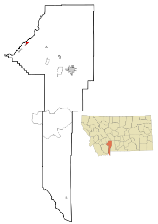
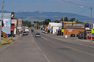
Martinsdale is an unincorporated community and census-designated place in southeastern Meagher County, Montana, United States.[2] As of the 2020 census, the population was 43.[3] The town was a station stop on the now-abandoned transcontinental main line of the Chicago, Milwaukee, St. Paul and Pacific Railroad ("the Milwaukee Road"), and is a community center for nearby ranches and farms. Martinsdale was the home of the poet Grace Stone Coates, author of Black Cherries,Mead & Mangel-Wurzel, and Portulacas in the Wheat. It was also the home of Charles M. Bair, one of the largest and most successful sheep ranchers in the United States, and the former Bair family home is now a museum.
Originally named "Gauglersville", the town changed to Martinsdale in 1878. The name was after Martin Maginnis, Montana Territory's delegate to Congress, who assisted the town in getting a post office.[5]
Wheatland County is a county in the U.S. state of Montana. As of the 2020 census, the population was 2,069. Its county seat is Harlowton. Wheatland County was established on February 22, 1917, with areas partitioned from Meagher and Sweet Grass counties. It was named for the abundant wheat-growing areas across the center portion of the new county's area.
Meagher County is a county located in the U.S. state of Montana. As of the 2020 census, the population was 1,927. Its county seat is White Sulphur Springs.
Geraldine is a town in Chouteau County, Montana, United States. The population was 207 at the 2020 census. The area around the town is an agricultural, largely wheat-producing, region.
Ismay is a town in Custer County, Montana, United States. There is a post office at Ismay, and a church, and no other businesses or services. The population was 17 at the 2020 census. The town is the least-populous incorporated municipality in the state of Montana.
Glendive is a city in and the county seat of Dawson County, Montana, United States, and home to Dawson Community College. Glendive was established by the Northern Pacific Railway when they built the transcontinental railroad across the northern tier of the western United States from Minnesota to the Pacific Coast. The town was the headquarters for the Yellowstone Division that encompassed 875 route miles (1,408 km); 546 (879) in main line and 328 (528) in branches with the main routes from Mandan, North Dakota, to Billings, Montana, and from Billings to Livingston. The town of Glendive is an agricultural and ranching hub of eastern Montana sited between the Yellowstone River and the Badlands. Makoshika State Park is located just east of Glendive.
Three Forks is a city in Gallatin County, Montana, United States and is located within the watershed valley system of both the Missouri and Mississippi rivers drainage basins — and is historically considered the birthplace or start of the Missouri River. The population was 1,989 at the 2020 census. The city of Three Forks is named so because it lies geographically near the point, in nearby Missouri Headwaters State Park, where the Jefferson, Madison, and Gallatin rivers converge to form the Missouri River — the longest single river in North America, as well as the major portion of the Missouri–Mississippi River System from the headwaters near Three Forks to its discharge into the Gulf of Mexico. Three Forks is part of the Bozeman, MT Micropolitan Statistical Area of approximately 100,000 people and located thirty miles west of Bozeman.
White Sulphur Springs is a city in and the county seat of Meagher County, Montana, United States. The population was 955 at the 2020 census.
Roundup is a city in and the county seat of Musselshell County, Montana, United States. The population was 1,742 during the 2020 census.
Harlowton is a city in and the county seat of Wheatland County, Montana, United States. The population was 955 at the 2020 census.
Ballantine is a census-designated place (CDP) in Yellowstone County, Montana, United States. It lies approximately nine miles (14 km) northeast of Billings on Interstate 94. The population was 346 at the 2000 census. Ballantine, along with the communities of Pompey's Pillar, Worden, and Huntley, is part of the Huntley Project, an irrigation district created by the United States Bureau of Reclamation. The majority of Ballantine's population lives on scattered farms and ranches surrounding the actual townsite.
Stanford is a town in and the county seat of Judith Basin County, Montana, United States. The population was at 403 as of the 2020 census.
The Musselshell River is a tributary of the Missouri River, 341.9 miles (550.2 km) long from its origins at the confluence of its North and South Forks near Martinsdale, Montana to its mouth on the Missouri River. It is located east of the Continental divide entirely within Montana in the United States. Counting its pre-confluence tributaries, it measures 425–500 miles (684–805 km) in length.
The North Fork Musselshell River is a tributary of the Musselshell River, approximately 35 miles (56 km) long, in Montana in the United States.
The South Fork Musselshell River is a tributary of the Musselshell River in south central Montana in the United States.
Sixteen is a former unincorporated community in southwestern Meagher County, Montana, United States. The town was a station stop on the transcontinental main line of the Chicago, Milwaukee, St. Paul and Pacific Railroad, and was a community center for a small number of area ranchers and homesteaders. The rail line through Sixteen was originally constructed in 1895 by the Montana Railroad, and the town served as a base camp for railway construction crews.
Charles M. Bair (1857–1943) was an early railroading businessman who also became one of the largest sheep ranchers in the United States. He had two daughters, Alberta (1895-1993) and Marguerite (1889-1976).
Copperopolis was a mining community situated in Meagher County, Montana, United States.
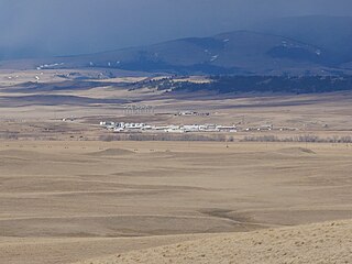
Martinsdale Colony is a Hutterite community and census-designated place (CDP) in Wheatland County, Montana, United States. It is on the western edge of the county, bordered to the west by Meagher County and 4 miles (6 km) northeast of the unincorporated community of Martinsdale. The Musselshell River forms the southern edge of the CDP.
This page is based on this Wikipedia article Text is available under the CC BY-SA 4.0 license; additional terms may apply. Images, videos and audio are available under their respective licenses.