Mason County | |
---|---|
Coordinates: 47°21′N123°11′W / 47.35°N 123.18°W | |
Country | United States |
State | Washington |
Founded | March 13, 1854 |
Named for | Charles H. Mason |
Seat | Shelton |
Largest city | Shelton |
Area | |
• Total | 1,051 sq mi (2,720 km2) |
• Land | 959 sq mi (2,480 km2) |
• Water | 92 sq mi (240 km2) 8.7% |
Population (2020) | |
• Total | 65,726 |
• Estimate (2022) | 68,166 |
• Density | 63/sq mi (24/km2) |
Time zone | UTC−8 (Pacific) |
• Summer (DST) | UTC−7 (PDT) |
Congressional district | 6th |
Website | www |
Mason County is a county located in the U.S. state of Washington. As of the 2020 census, the population was 65,726. [1] The county seat and only incorporated city is Shelton. [2] The county was formed out of Thurston County on March 13, 1854. [3] Originally named Sawamish County, it took its present name in 1864 in honor of Charles H. Mason, the first Secretary of Washington Territory. [3] [4]
Mason County comprises the Shelton micropolitan statistical area and is included in the Seattle-Tacoma combined statistical area.
According to the United States Census Bureau, the county has a total area of 1,051 square miles (2,720 km2), of which 959 square miles (2,480 km2) is land and 92 square miles (240 km2) (8.7%) is water. [5]
Oakland Bay
Census | Pop. | Note | %± |
---|---|---|---|
1860 | 162 | — | |
1870 | 289 | 78.4% | |
1880 | 639 | 121.1% | |
1890 | 2,826 | 342.3% | |
1900 | 3,810 | 34.8% | |
1910 | 5,156 | 35.3% | |
1920 | 4,919 | −4.6% | |
1930 | 10,060 | 104.5% | |
1940 | 11,603 | 15.3% | |
1950 | 15,022 | 29.5% | |
1960 | 16,251 | 8.2% | |
1970 | 20,918 | 28.7% | |
1980 | 31,184 | 49.1% | |
1990 | 38,341 | 23.0% | |
2000 | 49,405 | 28.9% | |
2010 | 60,699 | 22.9% | |
2020 | 65,726 | 8.3% | |
2022 (est.) | 68,166 | [6] | 3.7% |
U.S. Decennial Census [7] 1790–1960 [8] 1900–1990 [9] 1990–2000 [10] 2010–2020 [1] |
As of the 2000 census, there were 49,405 people, 18,912 households, and 13,389 families living in the county. The population density was 51 people per square mile (20 people/km2). There were 25,515 housing units at an average density of 26 units per square mile (10 units/km2). The racial makeup of the county was 88.46% White, 1.19% Black or African American, 3.72% Native American, 1.05% Asian, 0.45% Pacific Islander, 2.10% from other races, and 3.03% from two or more races. 4.78% of the population were Hispanic or Latino of any race. 16.7% were of German, 9.9% Irish, 9.8% English, 8.6% United States or American and 6.8% Norwegian ancestry.
There were 18,912 households, out of which 28.90% had children under the age of 18 living with them, 56.90% were married couples living together, 9.20% had a female householder with no husband present, and 29.20% were non-families. 23.30% of all households were made up of individuals, and 9.90% had someone living alone who was 65 years of age or older. The average household size was 2.49 and the average family size was 2.89.
In the county, the population was spread out, with 23.50% under the age of 18, 7.70% from 18 to 24, 26.50% from 25 to 44, 25.80% from 45 to 64, and 16.50% who were 65 years of age or older. The median age was 40 years. For every 100 females there were 107.00 males. For every 100 females age 18 and over, there were 107.30 males.
The median income for a household in the county was $39,586, and the median income for a family was $44,246. Males had a median income of $37,007 versus $25,817 for females. The per capita income for the county was $18,056. About 8.80% of families and 12.20% of the population were below the poverty line, including 17.30% of those under age 18 and 4.90% of those age 65 or over.
As of the 2010 census, there were 60,699 people, 23,832 households, and 16,057 families living in the county. [11] The population density was 63.3 inhabitants per square mile (24.4/km2). There were 32,518 housing units at an average density of 33.9 units per square mile (13.1 units/km2). [12] The racial makeup of the county was 86.1% white, 3.7% American Indian, 1.2% Asian, 1.1% black or African American, 0.4% Pacific islander, 3.4% from other races, and 4.1% from two or more races. Those of Hispanic or Latino origin made up 8.0% of the population. [11] In terms of ancestry, 19.7% were German, 13.8% were English, 13.5% were Irish, 6.7% were Norwegian, and 4.9% were American. [13]
Of the 23,832 households, 27.0% had children under the age of 18 living with them, 52.5% were married couples living together, 9.5% had a female householder with no husband present, 32.6% were non-families, and 25.3% of all households were made up of individuals. The average household size was 2.45 and the average family size was 2.87. The median age was 44.4 years. [11]
The median income for a household in the county was $48,104 and the median income for a family was $56,809. Males had a median income of $44,992 versus $33,982 for females. The per capita income for the county was $22,530. About 11.1% of families and 15.6% of the population were below the poverty line, including 21.0% of those under age 18 and 9.0% of those age 65 or over. [14]
Year | Republican | Democratic | Third party | |||
---|---|---|---|---|---|---|
No. | % | No. | % | No. | % | |
2020 | 18,710 | 50.16% | 17,269 | 46.29% | 1,324 | 3.55% |
2016 | 13,677 | 47.16% | 11,993 | 41.35% | 3,333 | 11.49% |
2012 | 12,761 | 44.79% | 14,764 | 51.82% | 964 | 3.38% |
2008 | 12,600 | 44.19% | 15,050 | 52.78% | 863 | 3.03% |
2004 | 11,987 | 47.20% | 12,894 | 50.78% | 513 | 2.02% |
2000 | 10,257 | 45.63% | 10,876 | 48.38% | 1,347 | 5.99% |
1996 | 7,149 | 34.45% | 10,088 | 48.62% | 3,513 | 16.93% |
1992 | 5,776 | 29.43% | 8,076 | 41.15% | 5,774 | 29.42% |
1988 | 7,426 | 47.77% | 7,826 | 50.34% | 293 | 1.88% |
1984 | 8,410 | 53.74% | 7,007 | 44.77% | 233 | 1.49% |
1980 | 6,745 | 49.10% | 5,241 | 38.15% | 1,751 | 12.75% |
1976 | 4,758 | 42.14% | 6,060 | 53.67% | 473 | 4.19% |
1972 | 4,873 | 53.10% | 3,907 | 42.57% | 397 | 4.33% |
1968 | 3,397 | 39.55% | 4,540 | 52.85% | 653 | 7.60% |
1964 | 2,549 | 31.58% | 5,514 | 68.32% | 8 | 0.10% |
1960 | 3,703 | 46.86% | 4,183 | 52.94% | 16 | 0.20% |
1956 | 4,026 | 51.05% | 3,840 | 48.69% | 20 | 0.25% |
1952 | 3,827 | 49.70% | 3,830 | 49.74% | 43 | 0.56% |
1948 | 2,524 | 38.82% | 3,613 | 55.58% | 364 | 5.60% |
1944 | 1,976 | 36.61% | 3,379 | 62.61% | 42 | 0.78% |
1940 | 1,775 | 33.20% | 3,465 | 64.81% | 106 | 1.98% |
1936 | 1,015 | 23.08% | 3,087 | 70.19% | 296 | 6.73% |
1932 | 995 | 25.50% | 2,181 | 55.89% | 726 | 18.61% |
1928 | 1,745 | 62.95% | 992 | 35.79% | 35 | 1.26% |
1924 | 902 | 49.02% | 179 | 9.73% | 759 | 41.25% |
1920 | 997 | 56.04% | 383 | 21.53% | 399 | 22.43% |
1916 | 764 | 44.32% | 779 | 45.19% | 181 | 10.50% |
1912 | 439 | 24.42% | 522 | 29.03% | 837 | 46.55% |
1908 | 553 | 56.60% | 318 | 32.55% | 106 | 10.85% |
1904 | 661 | 63.50% | 315 | 30.26% | 65 | 6.24% |
1900 | 514 | 51.40% | 455 | 45.50% | 31 | 3.10% |
1896 | 397 | 36.86% | 667 | 61.93% | 13 | 1.21% |
1892 | 352 | 42.00% | 356 | 42.48% | 130 | 15.51% |
Mason County has one hospital, Mason General Hospital, in Shelton, operated by Washington Public Hospital District No. 1. [20] [21] [22]
Skagit County is a county in the U.S. state of Washington. As of the 2020 census, the population was 129,523. The county seat and largest city is Mount Vernon. The county was formed in 1883 from Whatcom County and is named for the Skagit Indian tribe, which has been indigenous to the area prior to European-American settlement.
Lincoln County is a county located in the U.S. state of Washington. As of the 2020 census, the population was 10,876, making it the fifth-least populous county in the state. The county seat and largest city is Davenport.
Douglas County is a county located in the U.S. state of Washington. As of the 2020 census, its population was 42,938. The county seat is Waterville, while its largest settlement is East Wenatchee. The county was created out of Lincoln County on November 28, 1883 and is named for American statesman Stephen A. Douglas.
Chelan County is a county in the U.S. state of Washington. As of the 2020 census, its population was 79,074. The county seat and largest city is Wenatchee. The county was created out of Okanogan and Kittitas Counties on March 13, 1899. It derives its name from a Chelan Indian word meaning "deep water," likely a reference to 55-mile (89 km)-long Lake Chelan, which reaches a maximum depth of 1,486 feet (453 m).
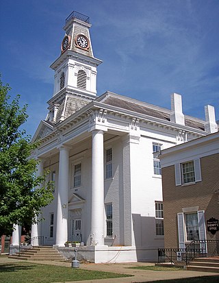
Morgan County is a county located in the U.S. state of Ohio. As of the 2020 census, the population was 13,802, making it the third-least populous county in Ohio. Its county seat is McConnelsville. The county was created in 1817 and later organized in 1819. It is named for Daniel Morgan, an officer in the American Revolutionary War.
Henry County is a county located in the U.S. state of Ohio. As of the 2020 census, the population was 27,662. Its county seat is Napoleon. The county was created in 1820 and later organized in 1834. It is named for American Founding Father Patrick Henry, the Virginian famous for his "give me liberty, or give me death!" speech.
Gallia County is a county located in the U.S. state of Ohio. As of the 2020 census, the population was 29,220. Its county seat and largest village is Gallipolis.
Defiance County is a county located in the U.S. state of Ohio. As of the 2020 census, the population was 38,286. Its county seat and largest city is Defiance. The county was named after an early Army fortification, Fort Defiance, which was so named by Mad Anthony Wayne to signify the settlers' "defiance" of the Indians. The Defiance, OH Micropolitan Statistical Area includes all of Defiance County.
Washington County is a county located in the U.S. state of Maine. As of the 2020 census, its population was 31,095, making it the third-least populous county in Maine. Its county seat is Machias. The county was established on June 25, 1789. It borders the Canadian province of New Brunswick.
Penobscot County is a county in the U.S. state of Maine, named for the Penobscot people in Wabanakik. As of the 2020 census, the population was 152,199, making it the third-most-populous county in Maine. Its county seat is Bangor. The county was established on February 15, 1816, from part of Hancock County when the area was still part of Massachusetts. Penobscot County is home to the University of Maine.
Beddington is a town in Washington County, Maine, United States. The population was 60 at the 2020 census. It is the third-smallest organized town in Maine after Frye Island and Frenchboro.
Princeton is a town in Washington County, Maine, United States. The town was named after Princeton, Massachusetts. The population was 745 at the 2020 census.
Talmadge is a town in Washington County, Maine, United States. The town was named after landowner Benjamin Tallmadge. The population was 70 at the 2020 census.
Scottville is a city in Mason County in the U.S. state of Michigan. The population was 1,356 at the 2020 census.
Herman is a village in Washington County, Nebraska, United States. The population was 268 at the 2010 census.
Washington is a village in Washington County, Nebraska, United States. The population was 150 at the 2010 census.
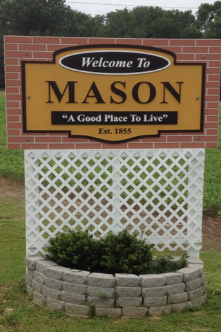
Mason is a town in Tipton County, Tennessee. The population was 1,609 at the 2010 census. Mason is located along U.S. Route 70, and is home to a federal detention facility.
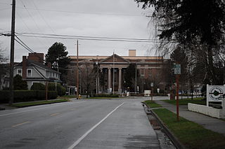
Shelton is a city in and the county seat of Mason County, Washington, United States. Shelton is the westernmost city on Puget Sound. The population was 10,371 at the 2020 census. Shelton has a council–manager form of government and was the last city in Washington to use a mayor–commission form of government.
Mason, also known as Mason City, is a town in Mason County, West Virginia, United States. The population was 865 at the 2020 census. It is part of the Point Pleasant, WV–OH Micropolitan Statistical Area.
Mason is a village in Bayfield County, Wisconsin, United States. The population was 93 at the 2010 census. The village is located within the Town of Mason.