
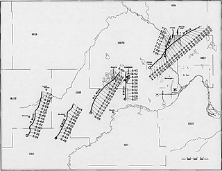
On March 18, 1925, one of the deadliest tornado outbreaks in recorded history generated at least twelve significant tornadoes and spanned a large portion of the midwestern and southern United States. In all, at least 751 people were killed and more than 2,298 were injured, making the outbreak the deadliest tornado outbreak, March 18 the deadliest tornado day, and 1925 the deadliest tornado year in U.S. history. The outbreak generated several destructive tornadoes in Missouri, Illinois, and Indiana on the same day, as well as significant tornadoes in Alabama and Kansas. In addition to confirmed tornadoes, there were undoubtedly others with lesser impacts, the occurrences of which have been lost to history.

From April 9–11, 1947, a significant tornado outbreak produced catastrophic effects over portions of the southern Great Plains, in the contiguous United States. The outbreak generated at least 12, and possibly 17 or more, tornadoes, many of which were significant. On Wednesday, April 9, a series of related tornadoes spawned by a single supercell, dubbed the Glazier–Higgins–Woodward tornadoes, swept through the U.S. states of Texas, Oklahoma, and Kansas. Most of the damage and nearly all of the deaths are still blamed on one large tornado, known as the Glazier–Higgins–Woodward tornado, that traveled 98 mi (158 km) from Texas to Oklahoma, beginning over the South Plains. This event, up to nearly 2 mi (3.2 km) in width, was often compared to the Tri-State tornado, because it was originally thought to have left a 198-to-221-mile-long path, was similarly large and intense for much of its path, and was also retroactively rated F5 on the modern-day Fujita scale, but it is now believed to have been part of a 125-to-170-mile-long family of nine or 10 tornadoes.
On May 5–8, 1965, a significant tornado outbreak affected much of the Central United States. For four consecutive days, tornado outbreaks produced at least three significant (F2+) tornadoes each day, and at least two violent (F4–F5) tornadoes on three of the four days. The entire sequence generated 37 significant tornadoes, including at least nine violent tornadoes, one of which was rated F5. On May 5, two F4s struck Iowa, including a long-tracked tornado family that injured 11 people. On May 6, an outbreak of six strong tornadoes, four of them violent F4s, affected Minneapolis and St. Paul, Minnesota, and has been nicknamed "The Longest Night", killing 13 people and causing major damages—at the time the most damaging single weather event in Minnesota history. Three of the six tornadoes occurred on the ground simultaneously, and two of them hit the section of Minnesota State Highway 100 and University Avenue in the city of Fridley. Both Fridley tornadoes damaged 1,100 homes and destroyed about 425; total losses reached $14.5 million, $5 million of which was to the Fridley school system.

On February 21–22, 1971, a devastating tornado outbreak, colloquially known as the Mississippi Delta outbreak, struck portions of the Lower Mississippi and Ohio River valleys in the Southern and Midwestern United States. The outbreak generated strong tornadoes from Texas to Ohio and North Carolina. The two-day severe weather episode produced at least 19 tornadoes, and probably several more, mostly brief events in rural areas; killed 123 people across three states; and wrecked entire communities in the state of Mississippi. The strongest tornado of the outbreak was an F5 that developed in Louisiana and crossed into Mississippi, killing 48 people, while the deadliest was an F4 that tracked across Mississippi and entered Tennessee, causing 58 fatalities in the former state. The former tornado remains the only F5 on record in Louisiana, while the latter is the deadliest on record in Mississippi since 1950. A deadly F4 also affected other parts of Mississippi, causing 13 more deaths. Other deadly tornadoes included a pair of F3s—one each in Mississippi and North Carolina, respectively—that collectively killed five people.

The tornado outbreak sequence of May 1896 was a series of violent and deadly tornado outbreaks that struck much of the Central and Southern United States from May 15 to 28, 1896. It is considered one of the worst tornado outbreak sequences on record with tornado expert Tom Grazulis stating that the week of May 24–28 was "perhaps the most violent single week of tornado activity in United States history". There were four particularly notable tornado outbreaks during the two-week period. It produced three F5 tornadoes as well as the third deadliest tornado ever in United States history. A total of at least 484 people were killed during the entire outbreak sequence by at least 38 different tornadoes which struck Texas, Oklahoma, Kansas, Nebraska, Kentucky, Iowa, Illinois, Michigan, Missouri, Pennsylvania, New Jersey and Maryland.
Ruskin Heights is a neighborhood in southeast Kansas City, Missouri, Jackson County. This neighborhood was made in the early 1950s as a postwar suburb on former farmland. It had a total population of 23,874 people in 2020, making it one of the most densely populated neighborhoods of Kansas City. It has a total land area of approximately 0.794 square miles (2.06 km2). It is mostly flat, but slightly elevated at some points. The ZIP Code is 64134.
On December 18–20, 1957, a significant tornado outbreak sequence affected the southern Midwest and the South of the contiguous United States. The outbreak sequence began on the afternoon of December 18, when a low-pressure area approached the southern portions of Missouri and Illinois. Supercells developed and proceeded eastward at horizontal speeds of 40 to 45 miles per hour, yielding what was considered the most severe tornado outbreak in Illinois on record so late in the calendar year. Total losses in the state were estimated to fall within the range of $8–$10 million.

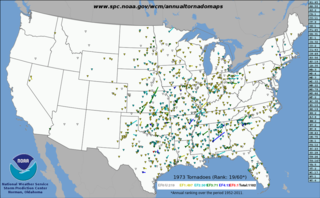
This page documents the tornadoes and tornado outbreaks of 1974, primarily in the United States. Most tornadoes form in the U.S., although some events may take place internationally. Tornado statistics for older years like this often appear significantly lower than modern years due to fewer reports or confirmed tornadoes.
This page documents notable tornadoes and tornado outbreaks worldwide in 1973, but mostly features events in the United States. According to tornado researcher Thomas P. Grazulis, documentation of tornadoes outside the United States was historically less exhaustive, owing to the lack of monitors in many nations and, in some cases, to internal political controls on public information. Most countries only recorded tornadoes that produced severe damage or loss of life. Consequently, available documentation in 1973 mainly covered the United States. On average, most recorded tornadoes, including the vast majority of significant—F2 or stronger—tornadoes, form in the U.S., although as many as 500 may take place internationally. Some locations, like Bangladesh, are as prone to violent tornadoes as the U.S., meaning F4 or greater events on the Fujita scale.

This page documents the tornadoes and tornado outbreaks of 1971, primarily in the United States. Most tornadoes form in the U.S., although some events may take place internationally. Tornado statistics for older years like this often appear significantly lower than modern years due to fewer reports or confirmed tornadoes.

From April 2–3, 1982, a major tornado outbreak resulted in over 60 tornadoes and 30 fatalities, primarily over portions of Northeast Texas and Southwest Arkansas, as well as Southeastern Oklahoma. Three of the tornadoes were rated F4, and one officially was recorded as an F5 near Broken Bow, Oklahoma, all on April 2. Beginning on April 2, a series of tornado-producing supercells formed across portions of northeastern Texas and southeastern Oklahoma. One produced an F5 tornado, the first since April 4, 1977, which crossed mostly rural areas near Speer and Broken Bow, and deposited a motel sign from Broken Bow 30 miles (48 km) away in Arkansas. The F5 tornado resulted in no fatalities, but an F4 tornado in Paris, Texas, resulted in 10 fatalities and 170 injuries. Additionally, the Storm Prediction Center, known then as the Severe Local Storms Unit, issued its first officially documented high risk on April 2 as well as the first tornado watch to contain the wording Particularly Dangerous Situation (PDS).
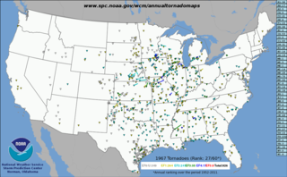
This page documents the tornadoes and tornado outbreaks of 1967, primarily in the United States. Most tornadoes form in the U.S., although some events may take place internationally. Tornado statistics for older years like this often appear significantly lower than modern years due to fewer reports or confirmed tornadoes.

This page documents the tornadoes and tornado outbreaks of 1958, primarily in the United States. Most tornadoes form in the U.S., although some events may take place internationally. Tornado statistics for older years like this often appear significantly lower than modern years due to fewer reports or confirmed tornadoes.

This page documents the tornadoes and tornado outbreaks of 1957, primarily in the United States. Most tornadoes form in the U.S., although some events may take place internationally. Tornado statistics for older years like this often appear significantly lower than modern years due to fewer reports or confirmed tornadoes.
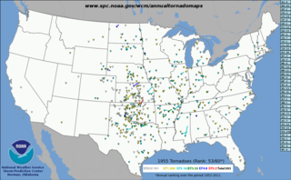
This page documents the tornadoes and tornado outbreaks of 1955, primarily in the United States. Most tornadoes form in the U.S., although some events may take place internationally. Tornado statistics for older years like this often appear significantly lower than modern years due to fewer reports or confirmed tornadoes.

This page documents the tornadoes and tornado outbreaks of 1954, primarily in the United States. Most tornadoes form in the U.S., although some events may take place internationally. Tornado statistics for older years like this often appear significantly lower than modern years due to fewer reports or confirmed tornadoes.

A deadly and destructive outbreak sequence of 23 tornadoes struck parts of the Great Plains and the Great Lakes in late-June 1957. At least seven significant tornadoes (F2+) touched down during the outbreak sequence. The most devastating storm was a large, violent, and catastrophic 500-yard-wide F5 tornado family that struck Fargo, North Dakota on Thursday, June 20, 1957, killing 10 people and becoming the deadliest tornado ever recorded in North Dakota. The outbreak caused 11 fatalities, 105 injuries, and $25.883 million in damage.

This page documents the tornadoes and tornado outbreaks of 1949, primarily in the United States. Most recorded tornadoes form in the U.S., although some events may take place internationally. Tornado statistics for older years like this often appear significantly lower than modern years due to fewer reports or confirmed tornadoes.
This page documents the tornadoes and tornado outbreaks of 1947, primarily in the United States. Most recorded tornadoes form in the U.S., although some events may take place internationally. Tornado statistics for older years like this often appear significantly lower than modern years due to fewer reports or confirmed tornadoes.


