McCarthy, Alaska

Last updated

McCarthy, Alaska
CDP
McCarthy Alaska.jpg
The old McCarthy hardware store
AKMap-doton-McCarthy.PNG
Location of McCarthy, Alaska
Coordinates: 61°25′58″N142°54′39″W / 61.43278°N 142.91083°W / 61.43278; -142.91083 [1]
CountryUnited States
State Alaska
Census Area Copper River
Government
   State senator Click Bishop (R)
   State rep. Mike Cronk (R)
Area
[2]
  Total149.47 sq mi (387.14 km2)
  Land149.47 sq mi (387.14 km2)
  Water0.00 sq mi (0.00 km2)
Elevation
1,401 ft (427 m)
Population
 (2020)
  Total107
  Density0.72/sq mi (0.28/km2)
Time zone UTC-9 (Alaska (AKST))
  Summer (DST) UTC-8 (AKDT)
Area code 907
FIPS code 02-45790
GNIS feature ID1406098

McCarthy is a census-designated place (CDP) in Copper River Census Area, Alaska, United States. It is in Wrangell-St. Elias National Park and Preserve. The population was 107 at the 2020 census, up from 28 in 2010. [3]

Contents

Geography and location

Aerial image from the 1930s Alaska - McCarthy through Kodiak - NARA - 23939741.jpg
Aerial image from the 1930s
McCarthy in 1939 Landing Fields - Alaska - Manley Hot Springs through McCarthy - NARA - 68158888 (cropped).jpg
McCarthy in 1939

McCarthy is 120 mi (190 km) northeast of Cordova at the foot of the Wrangell Mountains. According to the United States Census Bureau, the CDP of McCarthy has a total area of 148.3 square miles (384 km2). None of the area is covered with water. It is connected to the outside world via the McCarthy Road spur of the Edgerton Highway from Chitina, and must be passed through to reach Kennecott, which is also within the McCarthy CDP. Historically, from the end of the road one had to cross the Kennecott River and then a smaller stream using manually propelled ropeways, but a footbridge was built in 1997. Visitors can walk to McCarthy in about 15 minutes, although shuttle vans and buses are available during the tourist season from the bridge to both McCarthy and Kennecott. [4] A private service bridge for vehicle traffic was constructed in 2004 downstream from the footbridge, but use is only available to residents, businesses, and the National Park Service for an annual fee. [5]

Climate

McCarthy has a subarctic climate (Köppen: Dsc).

Climate data for McCarthy, Alaska (1991–2020 normals, extremes 1984–2017)
MonthJanFebMarAprMayJunJulAugSepOctNovDecYear
Record high °F (°C)44
(7)
54
(12)
56
(13)
71
(22)
86
(30)
90
(32)
90
(32)
86
(30)
72
(22)
75
(24)
58
(14)
56
(13)
90
(32)
Mean maximum °F (°C)34.6
(1.4)
42.0
(5.6)
48.3
(9.1)
59.0
(15.0)
74.7
(23.7)
82.5
(28.1)
82.5
(28.1)
78.6
(25.9)
66.7
(19.3)
54.6
(12.6)
39.7
(4.3)
37.4
(3.0)
84.4
(29.1)
Mean daily maximum °F (°C)6.0
(−14.4)
20.7
(−6.3)
32.9
(0.5)
47.7
(8.7)
62.2
(16.8)
69.7
(20.9)
71.4
(21.9)
66.8
(19.3)
55.5
(13.1)
38.6
(3.7)
17.3
(−8.2)
9.2
(−12.7)
41.5
(5.3)
Daily mean °F (°C)−1.6
(−18.7)
9.7
(−12.4)
18.2
(−7.7)
34.6
(1.4)
46.6
(8.1)
54.3
(12.4)
57.3
(14.1)
53.5
(11.9)
44.3
(6.8)
29.4
(−1.4)
9.7
(−12.4)
2.3
(−16.5)
29.9
(−1.2)
Mean daily minimum °F (°C)−9.1
(−22.8)
−1.3
(−18.5)
3.5
(−15.8)
21.6
(−5.8)
30.9
(−0.6)
38.9
(3.8)
43.3
(6.3)
40.2
(4.6)
33.1
(0.6)
20.2
(−6.6)
2.0
(−16.7)
−4.5
(−20.3)
18.2
(−7.7)
Mean minimum °F (°C)−40.6
(−40.3)
−28.5
(−33.6)
−23.9
(−31.1)
0.7
(−17.4)
19.7
(−6.8)
28.3
(−2.1)
34.0
(1.1)
28.0
(−2.2)
17.3
(−8.2)
−4.7
(−20.4)
−27.4
(−33.0)
−32.9
(−36.1)
−46.9
(−43.8)
Record low °F (°C)−55
(−48)
−49
(−45)
−41
(−41)
−21
(−29)
−1
(−18)
24
(−4)
28
(−2)
18
(−8)
6
(−14)
−22
(−30)
−46
(−43)
−50
(−46)
−55
(−48)
Average precipitation inches (mm)0.93
(24)
1.11
(28)
0.40
(10)
0.31
(7.9)
0.93
(24)
1.63
(41)
2.45
(62)
2.65
(67)
2.56
(65)
2.22
(56)
1.45
(37)
1.06
(27)
17.70
(450)
Average snowfall inches (cm)13.2
(34)
7.9
(20)
5.4
(14)
2.5
(6.4)
0.6
(1.5)
0.0
(0.0)
0.0
(0.0)
0.0
(0.0)
2.7
(6.9)
9.4
(24)
13.5
(34)
11.3
(29)
66.5
(169)
Average precipitation days (≥ 0.01 in)8.77.14.72.87.011.314.016.415.411.210.19.3118.0
Average snowy days (≥ 0.1 in)8.86.64.42.20.40.00.00.01.25.29.38.646.7
Source: NOAA [6] [7]

Demographics

Historical population
CensusPop.Note
1920 127
1930 115−9.4%
1940 49−57.4%
1990 25
2000 4268.0%
2010 28−33.3%
2020 107282.1%
U.S. Decennial Census [8]

McCarthy first reported on the 1920 U.S. Census as an unincorporated village. With the closure of the post office in 1943, [9] it did not report on the census from 1950 to 1980, though it unofficially returned 22 residents in 1980. It returned again beginning in 1990 when it was made a census-designated place (CDP).

As of the census [10] of 2000, there were 42 people, 26 households, and 6 families residing in the CDP. The population density was 0.3 inhabitants per square mile (0.12/km2). There were 47 housing units at an average density of 0.3 per square mile (0.12/km2). The racial makeup of the CDP was 100.00% White.

There were 26 households, out of which 15.4% had children under the age of 18 living with them, 15.4% were married couples living together, 3.8% had a female householder with no husband present, and 73.1% were non-families. 53.8% of all households were made up of individuals, and none had someone living alone who was 65 years of age or older. The average household size was 1.62 and the average family size was 2.14.

Drawn by an increase in tourism since the founding of Wrangell St. Elias National Park and Preserve, a significant portion of McCarthy's summer population resides elsewhere in the winter. This results in them not being counted during the censuses.

In the CDP, the age distribution of the population shows 9.5% under the age of 18, 9.5% from 18 to 24, 28.6% from 25 to 44, 47.6% from 45 to 64, and 4.8% who were 65 years of age or older. The median age was 46 years. For every 100 females, there were 147.1 males. For every 100 females age 18 and over, there were 153.3 males.

The median income for a household in the CDP was $17,188, and the median income for a family was $20,000. The per capita income for the CDP was $16,045. There were no families and 15.2% of the population living below the poverty line, including no under eighteens and none of those over 65.

History

1917 map depicting copper and gold mining in the area. "x" depicts copper while "o" depicts gold. McCarthy, Alaska.PNG
1917 map depicting copper and gold mining in the area. "x" depicts copper while "o" depicts gold.
Railroads at McCarthy Alaska - McCarthy through Kodiak - NARA - 23939743.jpg
Railroads at McCarthy

For centuries, Athabascans hunted in the area of McCarthy. Chief Nikolai and his band of Athabaskan Natives had a summer camp at Dan Creek, 15 miles east of McCarthy, where they collected copper nuggets from Dan Creek. Their permanent camp was on the Copper River at the village of Taral near Chitina where they fished for salmon.

Copper was discovered between the Kennicott Glacier and McCarthy Creek in 1900, after which Kennicott Mine, Kennecott Mining Company, and company town of Kennecott were created. Due to a clerical error, the corporation and town used the spelling of Kennecott instead of Kennicott, named for Kennicott Glacier in the valley below the town. The glacier was named after Robert Kennicott, a naturalist who explored in Alaska in the mid-1800s.

Partly because alcoholic beverages and prostitution were forbidden in Kennecott, McCarthy grew as an area to provide illicit services not available in the company town. It grew quickly into a major town with a gymnasium, a hospital, a school, a bar and a brothel. The Copper River and Northwestern Railway reached McCarthy in 1911.

The bulk of McCarthy's main road Main Street of McCarthy (Alaska).JPG
The bulk of McCarthy's main road

In 1938, the copper deposits were mostly gone and the town was mostly abandoned. The railroad discontinued service that year. Over its 30-year operation, U.S. $200 million in ore was extracted from the mine, making it the richest concentration of copper ore in the world.

The population of McCarthy and Kennecott fell to almost zero until the 1970s, when the area began to draw young people from the many who came to Alaska in the '70s for adventure and the big money of the Trans Alaska Pipeline project. In the '80s, after the area was designated Wrangell-St. Elias National Park (1980), it began to draw some adventurous tourists to the new national park. The few people that lived there began to provide a variety of tourist services. There has always been at least one family living in the McCarthy area since 1953.

The old mine buildings, artifacts, and colorful history attract visitors during the summer months. The Kennecott and McCarthy area ranks as one of the United States' most endangered landmarks by the National Trust for Historic Places. Emergency stabilization of the old buildings has been done and more will be required.

In 2014, the TV show Edge of Alaska premiered on Discovery Channel. [11] The show has caused controversy though, as many town residents feel the town is portrayed in a bad light due to the troublesome incidents that have occurred there.

1983 shooting

In an attempt to disrupt the Alaska pipeline, [12] 39-year-old Louis D. Hastings, armed with a .223-caliber Ruger Mini-14 semi-automatic rifle, [13] murdered six of the 22 citizens of McCarthy on March 1, 1983. The victims were Maxine Edwards, Harley King, Les and Flo Hegland, Tim Nash and Amy Lou Ashenden Nash. [12] He also wounded two people. In July 1984, Hastings was sentenced to 634 years in prison. [14]

This was the worst mass shooting in the history of Alaska.

This case, and the town of McCarthy, were showcased on the Discovery Channel's Alaska Ice Cold Killers episode "Frozen Terror". [15]

Related Research Articles

<span class="mw-page-title-main">Valdez–Cordova Census Area, Alaska</span> Census area in Alaska, United States

Valdez–Cordova Census Area was a census area located in the state of Alaska, United States. As of the 2010 census, the population was 9,636. It was part of the Unorganized Borough and therefore had no borough seat. On January 2, 2019, it was abolished and replaced by the Chugach Census Area and the Copper River Census Area.

<span class="mw-page-title-main">Yakutat, Alaska</span> Consolidated city-borough in Alaska, United States

The City and Borough of Yakutat is a borough in the state of Alaska. Yakutat was also the name of a former city within the borough. The name in Tlingit is Yaakwdáat. It is derived from an Eyak name, diyaʼqudaʼt, and was influenced by the Tlingit word yaakw.

<span class="mw-page-title-main">Chitina, Alaska</span> CDP in Alaska, United States

Chitina is a census-designated place (CDP) in Copper River Census Area, Alaska, United States. At the 2010 census the population was 126, up from 123 in 2000.

<span class="mw-page-title-main">Glennallen, Alaska</span> Town in Alaska

Glennallen is a census-designated place (CDP) in the Copper River Census Area in the Unorganized Borough of the U.S. state of Alaska. As of the 2020 census, the population of the CDP was 439, down from 483 in 2010. It is the most populated community in the census area.

<span class="mw-page-title-main">Slana, Alaska</span> CDP in Alaska, United States

Slana is a census-designated place (CDP) in the Copper River Census Area in the Unorganized Borough of the U.S. state of Alaska. As of the 2020 census, the population of the CDP was 116, down from 147 in 2010.

<span class="mw-page-title-main">Copper River (Alaska)</span> River in Alaska, United States

The Copper River or Ahtna River, Ahtna Athabascan ‘Atna’tuu, "river of the Ahtnas", Tlingit Eeḵhéeni, "river of copper", is a 290-mile (470 km) river in south-central Alaska in the United States. It drains a large region of the Wrangell Mountains and Chugach Mountains into the Gulf of Alaska. It is known for its extensive delta ecosystem, as well as for its prolific runs of wild salmon, which are among the most highly prized stocks in the world. The river is the tenth largest in the United States, as ranked by average discharge volume at its mouth.

<span class="mw-page-title-main">Wrangell–St. Elias National Park and Preserve</span> National park and wilderness preserve in Alaska, United States

Wrangell–St. Elias National Park and Preserve is an American national park and preserve managed by the National Park Service in south central Alaska. The park and preserve were established in 1980 by the Alaska National Interest Lands Conservation Act. The protected areas are included in an International Biosphere Reserve and are part of the Kluane/Wrangell–St. Elias/Glacier Bay/Tatshenshini-Alsek UNESCO World Heritage Site. The park and preserve form the largest area managed by the National Park Service with a total of 13,175,799.07 acres, an expanse larger than nine U.S. states and around the same size as Bosnia and Herzegovina or Croatia. 8,323,147.59 acres are designated as the national park, and the remaining 4,852,652.14 acres are designated as the preserve. The area designated as the national park alone is larger than the 47 smallest American national parks combined and is more than twice the size of all but two other national parks. Its area makes up over 15% of all national park designated land in the United States.

<span class="mw-page-title-main">Chitina River</span> River in Alaska, United States

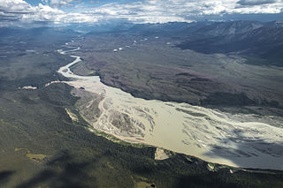
The Chitina River is a 274 km (170 mi) tributary of the Copper River in the U.S. state of Alaska. It begins in the Saint Elias Mountains at the base of Chitina Glacier and flows generally northwest through the Wrangell–St. Elias National Park and Preserve to meet the smaller river near Chitina. The watershed was once a major copper mining region.

<span class="mw-page-title-main">Kennecott, Alaska</span> United States historic place

Kennecott, also known as Kennicott and Kennecott Mines, is an abandoned mining camp in the Copper River Census Area in the U.S. state of Alaska that was the center of activity for several copper mines. It is located beside the Kennicott Glacier, northeast of Valdez, inside Wrangell-St. Elias National Park and Preserve. The camp and mines are now a National Historic Landmark District administered by the National Park Service.

<span class="mw-page-title-main">Copper River and Northwestern Railway</span> United States historic place

The Copper River and Northwestern Railway (CR&NW) consisted of two rail lines, the Copper River line and the Northwestern line. Michael James Heney had secured the right-of-way up the Copper River in 1904. He started building the railway from Cordova, Alaska in 1906. The town of Cordova, Alaska, was actually named by Heney on March 13, 1906, based on the original name given by Salvador Fidalgo. Both these railroads were abandoned and little remains of them. A 0-4-0 locomotive, "Ole", located near Goose City on a siding of the Alaska Anthracite Railroad Company is the only equipment left. Many of the holdings of the CR&NW railroad including Ole were acquired for this railroad by Mr. Clark Davis and his partners in 1908 after a major storm destroyed the Katalla area facilities in 1907. The town of Cordova would like to move Ole to a memorial site in Cordova to celebrate its role in these railroads. Ole was declared eligible for the National Register of Historic Places in 1988.

<span class="mw-page-title-main">Mount Blackburn</span> Volcano

Mount Blackburn is the highest peak in the Wrangell Mountains of Alaska in the United States. It is the fifth-highest peak in the United States and the twelfth-highest peak in North America. The mountain is an old, eroded shield volcano, the second-highest volcano in the U.S. behind Mount Bona and the fifth-highest in North America. It was named in 1885 by Lt. Henry T. Allen of the U.S. Army after Joseph Clay Stiles Blackburn, a U.S. senator from Kentucky. It is located in the heart of Wrangell – St. Elias National Park, the largest national park in the country.

<span class="mw-page-title-main">Kennicott Glacier</span> Glacier in Alaska

Kennicott Glacier is a glacier in the U.S. state of Alaska. It trends southeast 43 km (27 mi) from Mount Blackburn to its terminus at the head of the Kennicott River in the Wrangell Mountains. It is located in Wrangell-St. Elias National Park near the small town of McCarthy, Alaska and the historic ghost town of Kennecott, Alaska.

<span class="mw-page-title-main">McCarthy Road</span>

The McCarthy Road is a gravel-surfaced road that runs from the end of the Edgerton Highway in Chitina, Alaska, to about 1 mile (1.6 km) outside of McCarthy, Alaska.

<span class="mw-page-title-main">Nizina River</span>

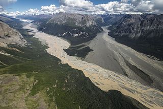
Nizina River is the largest tributary of the Chitina River in the U.S. state of Alaska. It is located in the Wrangell–St. Elias National Park and Preserve.

In an effort to thwart statehood and Alaskan home rule from Washington D.C., the Alaska Syndicate, was formed in 1906 by J. P. Morgan and Simon Guggenheim. The Syndicate purchased the Kennicott-Bonanza copper mine and had majority control of the Alaskan steamship and rail transportation. The syndicate also was in charge of a large part of the salmon industry.

The McCarthy Power Plant, also known as the Mother Lode Coalition Mining Company Power House and the Mother Lode Plant, is a historic power plant building in the small community of McCarthy, Alaska, in the heart of Wrangell-St. Elias National Park and Preserve. It is a three-story wood-frame structure with a clerestory roof, located on the banks of McCarthy Creek. It was built in 1917, after the arrival of the Copper River and Northwestern Railway in the area kicked of a building boom. The coal-fired power plant was built to provide electricity for the operation of a tramway and other facilities of the Kennecott mines. Most of the transmission lines and the tramway were destroyed by avalanches in 1919, and other changes made soon afterward made the power plant unnecessary, and its turbine was moved up to Kennecott.

<span class="mw-page-title-main">Donoho Peak</span> Mountain in Alaska

Donoho Peak is a 6,696-foot-elevation mountain summit located in the Wrangell Mountains, in the U.S. state of Alaska. The peak is situated in Wrangell-St. Elias National Park and Preserve, 6 mi (10 km) north-northwest of Kennecott, and 9 mi (14 km) north of McCarthy, at the confluence of the Kennicott Glacier and Root Glacier. The peak's name was reported in 1931 by the United States Geological Survey. The mountain lies within the Copper River drainage basin. Bears frequent the Donoho Peak and Donoho Lakes area. An ascent of the mountain involves 14 miles round-trip from Kennecott to the summit, including crossing the Root Glacier and gully scramble via the south aspect of the mountain. Ruins of the Regal Mine remain at an elevation of 5,440 feet on the south slope of the mountain. Only small amounts of copper ore were ever produced, however. On a clear day the summit of Donoho Peak offers views of Mount Blackburn to the northwest and the Stairway Icefall on Regal Mountain to the north-northeast.

<span class="mw-page-title-main">Fireweed Mountain</span> Mountain summit in Alaska, U.S.

Fireweed Mountain is a prominent 6,956-foot mountain summit located in the Wrangell Mountains, in the U.S. state of Alaska. The peak is situated in Wrangell-St. Elias National Park and Preserve, immediately west of the terminus of the Kennicott Glacier, and 5 mi (8 km) west-northwest of McCarthy. Precipitation runoff from the eight-mile-long by five-mile-wide mountain drains into tributaries of the Chitina River, which in turn is part of the Copper River drainage basin. The mountain's name was given in the 1920s by Molly Gilmore, a lifelong resident of the McCarthy area, who at age 17, named the mountain for the abundance of fireweed which grew on the mountain following forest fires. Although fireweed is the most common and well-known flower in Alaska, it is not commemorated on any other Alaskan mountain. The mountain's name was officially adopted in 1966 by the U.S. Board on Geographic Names. On a clear day the summit of Fireweed Mountain offers views of Mount Blackburn to the northwest, and Regal Mountain to the northeast.

<span class="mw-page-title-main">Porphyry Mountain</span> Mountain in Alaska

Porphyry Mountain is a prominent 6,375-foot mountain summit located in the Wrangell Mountains, in the U.S. state of Alaska. The peak is situated in Wrangell-St. Elias National Park and Preserve, immediately southeast of Kennecott, 4 mi (6 km) northeast of McCarthy, and, 5 mi (8 km) northwest of Sourdough Peak. Precipitation runoff from the mountain drains into tributaries of the Nizina River, which in turn is part of the Copper River drainage basin. The peak is notable for a rock glacier on its north slope. The mountain was so named because it is largely composed of porphyry, which is a very hard igneous rock. The mountain's local name was reported in 1908 by the U.S. Geological Survey. On a clear day the summit of Porphyry Mountain offers views of Donoho Peak, Kennicott Glacier, and Mount Blackburn to the northwest, and Fireweed Mountain to the west.

<span class="mw-page-title-main">Bonanza Peak (Alaska)</span> Mountain in Alaska

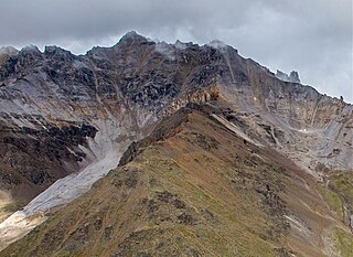
Bonanza Peak is a 6,983-foot mountain summit located in the Wrangell Mountains, in the U.S. state of Alaska. The peak was notable for its abundance of copper deposits which were mined from 1909 through 1938. The peak is situated in Wrangell-St. Elias National Park and Preserve, immediately northeast of Kennecott, 7 mi (11 km) northeast of McCarthy, 3.46 mi (6 km) north of Porphyry Mountain, and 5.2 mi (8 km) southeast of Donoho Peak. The confluence of the Kennicott and Root Glaciers lies below the mountain's west slope. Precipitation runoff from the mountain drains into tributaries of the Nizina River, which in turn is part of the Copper River drainage basin. The mountain's local name was reported in 1914 by the U.S. Geological Survey. On a clear day the summit of Bonanza Peak offers views of Sourdough Peak, Mount Blackburn, and Fireweed Mountain.

References

  1. "US Gazetteer files: 2010, 2000, and 1990". United States Census Bureau. February 12, 2011. Retrieved April 23, 2011.
  2. "2020 U.S. Gazetteer Files". United States Census Bureau. Retrieved October 29, 2021.
  3. "2020 Census Data – Cities and Census Designated Places" (Web). State of Alaska, Department of Labor and Workforce Development. Retrieved December 5, 2021.
  4. Staff (2007). "McCarthy Road". The Milepost (59th ed.). Augusta, Georgia: Morris Communications. p. 487. ISBN   978-1-892154-21-7.
  5. Rowland, Laurie. "Kennicott River Bridge". vlrc.org. Retrieved January 29, 2023.
  6. "Summary of Monthly Normals 1991–2020". National Oceanic and Atmospheric Administration . Retrieved June 17, 2021.
  7. "xmACIS2". National Oceanic and Atmospheric Administration . Retrieved August 8, 2023.
  8. "U.S. Decennial Census". Census.gov. Retrieved June 6, 2013.
  9. "Geological Survey Professional Paper". 1949.
  10. "U.S. Census website". United States Census Bureau . Retrieved January 31, 2008.
  11. "Edge of Alaska | Watch Full Episodes & More!".
  12. 1 2 Kizzia, Tom (July 28, 1984). "McCarthy killer gets 634 years". Anchorage Daily News . pp. a–1, a–16. Archived from the original on January 24, 2013. Retrieved August 13, 2012 via Google News Archive.
  13. "Weapon list found in mass murder case". The Gainesville Sun . Associated Press. March 10, 1983. p. 3A. Retrieved August 13, 2012 via Google News Archive.
  14. "Killer of six Alaskans gets a 634-year term". The New York Times . United Press International. July 30, 1984. Retrieved August 13, 2012.
  15. "Discovery – Official Site". www.discovery.com.