Big Bend National Park is an American national park located in West Texas, bordering Mexico. The park has national significance as the largest protected area of Chihuahuan Desert topography and ecology in the United States, and was named after a large bend in the Rio Grande/Río Bravo. The park protects more than 1,200 species of plants, more than 450 species of birds, 56 species of reptiles, and 75 species of mammals. Additional park activities include scenic drives, programs led by Big Bend park rangers, and stargazing.

The Chihuahuan Desert is a desert ecoregion designation covering parts of northern Mexico and the southwestern United States. It occupies much of far West Texas, the middle to lower Rio Grande Valley and the lower Pecos Valley in New Mexico, and a portion of southeastern Arizona, as well as the central and northern portions of the Mexican Plateau. It is bordered on the west by the Sonoran Desert, the Colorado Plateau, and the extensive Sierra Madre Occidental range, along with northwestern lowlands of the Sierra Madre Oriental range. Its largest, continual expanse is located in Mexico, covering a large portion of the state of Chihuahua, along with portions of Coahuila, north-eastern Durango, the extreme northern part of Zacatecas, and small western portions of Nuevo León. With an area of about 501,896 km2 (193,783 sq mi), it is the largest hot desert in North America. The desert is fairly young, existing for only 8000 years.

Guadalupe Mountains National Park is an American national park in the Guadalupe Mountains, east of El Paso, Texas. The mountain range includes Guadalupe Peak, the highest point in Texas at 8,751 feet (2,667 m), and El Capitan used as a landmark by travelers on the route later followed by the Butterfield Overland Mail stagecoach line. The ruins of a stagecoach station stand near the Pine Springs visitor center. The restored Frijole Ranch contains a small museum of local history and is the trailhead for Smith Spring. The park covers 86,367 acres in the same mountain range as Carlsbad Caverns National Park, about 25 miles (40 km) to the north in New Mexico. The Guadalupe Peak Trail winds through pinyon pine and Douglas-fir forests as it ascends over 3,000 feet (910 m) to the summit of Guadalupe Peak, with views of El Capitan and the Chihuahuan Desert.

Wallace Everette Pratt (1885–1981) was a pioneer American petroleum geologist. He is also notable for helping establish Guadalupe Mountains National Park through his donation of McKittrick Canyon. He is also notable for his marriage to Iris Calderhead, prominent advocate for sex equality and his classmate from the University of Kansas, in 1931.

West Texas is a loosely defined region in the U.S. state of Texas, generally encompassing the arid and semiarid lands west of a line drawn between the cities of Wichita Falls, Abilene, and Del Rio.
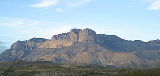
The Guadalupe Mountains are a mountain range located in West Texas and southeastern New Mexico. The range includes the highest summit in Texas, Guadalupe Peak, 8,751 ft (2,667 m), and the "signature peak" of West Texas, El Capitan, both of which are located within Guadalupe Mountains National Park. The Guadalupe Mountains are bordered by the Pecos River valley and Llano Estacado to the east and north, Delaware Mountains to the south, and Sacramento Mountains to the west. One of the clearest exposures of a prehistoric reef is preserved in the mountain range's bedrock geology. Bedrock contains fossils of reef-dwelling organisms from the Permian period, and the geology is widely studied, mostly by stratigraphers, paleontologists, and Paleoecologists.

Tonto National Monument is a National Monument in the Superstition Mountains, in Gila County of central Arizona. The area lies on the northeastern edge of the Sonoran Desert ecoregion, an arid habitat with annual rainfall of about 16 inches (400 mm). The Salt River runs through this area, providing a rare, year-round source of water.

Agave lechuguilla is an Agave species found only in the Chihuahuan Desert. The plant flowers once in its life and then dies.

The Franklin Mountains of Texas are a small range 23 miles (37 km) long, 3 miles (5 km) wide that extend from El Paso, Texas, north into New Mexico. The Franklins were formed due to crustal extension related to the Cenozoic Rio Grande rift. Although the present topography of the range and adjoining basins is controlled by extension during rifting in the last 10 million years, faults within the range also record deformation during the Laramide orogeny, between 85 and 45 million years ago.

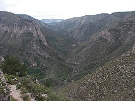
The Trans-Pecos, as originally defined in 1887 by the Texas geologist Robert T. Hill, is the distinct portion of Texas that lies west of the Pecos River. The term is considered synonymous with Far West Texas, a subdivision of West Texas. The Trans-Pecos is part of the Chihuahuan Desert, the largest desert in North America. It is the most mountainous and arid portion of the state, and most of its vast area is sparsely populated. Among the nine counties in the region are the five largest counties by area in Texas and eight of the eleven largest in the state. The area is known for the natural environment of the Big Bend and the gorge of the Rio Grande, part of which has been designated a National Wild and Scenic Rivers System. With the notable exceptions of Big Bend Ranch State Park, Big Bend National Park and the Guadalupe Mountains National Park, the vast majority of the Trans-Pecos region consists of privately owned ranchland. However, most of the region's population reside in the El Paso metropolitan area. Besides El Paso and its metropolitan area, the major cities are Pecos (12,916), Fort Stockton (8,466), and Alpine (6,035). All other settlements have under 5,000 people.

Aridoamerica denotes an ecological region spanning Northern Mexico and the Southwestern United States, defined by the presence of the culturally significant staple foodstuff Phaseolus acutifolius, a drought-resistant bean. Its dry, arid climate and geography stand in contrast to the verdant Mesoamerica of present-day central Mexico into Central America to the south and east, and the higher, milder "island" of Oasisamerica to the north. Aridoamerica overlaps with both.

The Solitario is a large geologic formation in Big Bend Ranch State Park in West Texas. When viewed from above, it suggests an impact crater; though it is actually the eroded remains of a laccolith. The approximate center of the Solitario is located 56.8 km (35.3 mi) east southeast of Presidio, Texas, just west of the line dividing Brewster County, Texas and Presidio County, Texas. The formation covers a circular area of approximately 135 km2 (52 sq mi). The geology of the Solitario is complex. In 1988, the state of Texas purchased the property containing the Solitario and created Big Bend Ranch State Park.

The white-throated woodrat is a species of rodent in the family Cricetidae. It is found from central Mexico north to Utah and Colorado in the United States. It is primarily a western species in the United States, extending from central Texas west to southeastern California. Populations east of the Rio Grande in New Mexico and Trans-Pecos Texas, previously considered to be variants of the white-throated woodrat, have since 1988 been assigned to the white-toothed woodrat.

Big Bend Ranch State Park is a 311,000-acre (126,000 ha) state park located on the Rio Grande in Brewster and Presidio counties, Texas. It is the largest state park in Texas. The closest major town is Presidio, Texas. The state park's head office is located in Lajitas, Texas at the Barton Warnock Visitor Center. It includes Colorado Canyon.
The Reserva Ecológica Municipal Sierra y Cañón de Jimulco is a protected natural area in Torreón, Coahuila, Mexico. Jimulco has a high mountain range of over 10,000 ft, a riparian area formed by the Aguanaval River, an endorrheic basin and an extensive valley with the characteristic flora and fauna of the Chihuahuan Desert. El Cañon del Realito and El Cañon de la Cabeza are two small canyons of great beauty formed by the Aguanaval.

Sclerocactus mariposensis, synonyms including Echinomastus mariposensis and Neolloydia mariposensis, is a rare species of cactus known by the common names Lloyd's fishhook cactus, golfball cactus, silver column cactus, and Mariposa cactus. It is native to a section of territory straddling the border between Brewster County, Texas, in the United States, and the states of Coahuila and Nuevo León in northeastern Mexico. It has been federally listed as a threatened species in the United States since 1979.
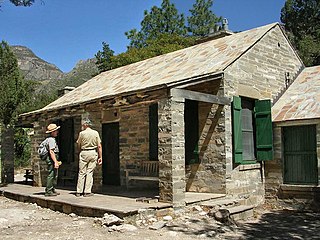
The Wallace Pratt Lodge was the summer residence of Wallace Pratt, the principal donor of the lands that would become Guadalupe Mountains National Park. Pratt was a petroleum geologist employed by the Humble Oil Company, scouting for oilfield leases in west Texas. Pratt visited the Guadalupe Mountains in 1921, and taking a liking to the place, he bought a quarter share of the McCombs Ranch. In 1929 Pratt bought out his partners, ending up owning a large portion of the canyon, which featured waterfalls flowing over travertine dams, a lush, quiet place in the high desert.
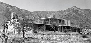
The Wallace E. Pratt House, also known as Ship on the Desert, was the residence of Wallace Pratt in what is now Guadalupe Mountains National Park in far western Texas. Pratt, a petroleum geologist for the Humble Oil & Refining Company, had previously built the Wallace Pratt Lodge in McKittrick Canyon a couple of miles to the north in the Guadalupe Mountains. Finding the cabin site to be remote and prone to being cut off by flooding, Pratt started construction of a new, modern residence on the east slope of the mountains. Work on the residence started in 1941. The house was designed by Long Island architect Newton Bevin, who lived for a time at the site with his wife, and built by contractor Ed Birdsall. Work was stopped by World War II, but resumed in 1945 and was completed the same year. In contrast to Pratt's rustic canyon cabin, the house, which Pratt named the Ship On The Desert, is an International Style house with horizontal lines and extensive glazing. Only 16 feet (4.9 m) wide and 110 feet (34 m) long, the house provides broad views to the east over the plains and the west to the mountains. The majority of the house is on a single level, with a "captain's bridge" over the dining room giving access to a rooftop terrace. A detached garage contained a guest bedroom. Apart from glass, the predominant material was local limestone in several shades.

The Sierra del Carmen, also called the Sierra Maderas del Carmen, is a northern finger of the Sierra Madre Oriental in the state of Coahuila, Mexico. The Sierra begins at the Rio Grande at Big Bend National Park and extends southeast for about 72 kilometres (45 mi), reaching a maximum elevation of 2,720 metres (8,920 ft). Part of the Sierra del Carmen is protected in the Maderas del Carmen Biosphere Reserve as part of a bi-national effort to conserve a large portion of the Chihuahua Desert in Mexico and Texas.

The Cañón de Santa Elena Flora and Fauna Protection Area is a protected area for plants and wildlife in the Mexican municipalities of Manuel Benavides and Ojinaga, in the state of Chihuahua. It was founded on November 7, 1994 and has an area of 277,209 hectares.