Mellingen is first mentioned in 1045 as Mellingen though this comes from a 16th-century copy of the original. Around 1217–39 it was mentioned as Menelingen.[3]
Geography
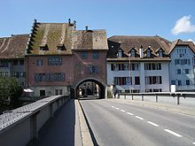
Reuss bridge from 1928 (first mentioned 1253) with the portal from 1526
Mellingen has an area, as of 2006[update], of 4.8km2 (1.9sqmi). Of this area, 36.2% is used for agricultural purposes, while 32.4% is forested. Of the rest of the land, 26.7% is settled (buildings or roads) and the remainder (4.8%) is non-productive (rivers or lakes).[4]
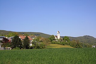
The municipality is located in the Baden district. The compact, walled medieval city center straddles the river Reuss. The old city is surrounded by a number of newer settlements. It has grown into a center of the small Unteres Reusstal region.
Coat of arms
The blazon of the municipal coat of arms is "Or a Lion rampant Gules and in chief of the last a Bar[rulet] Argent."[5]
Demographics
Mellingen has a population (as of 31 December 2020) of 5,865.[6]As of 2008[update], 29.6% of the population was made up of foreign nationals.[7] Over the last 10 years the population has grown at a rate of 10.1%. Most of the population (as of 2000[update]) speaks German (83.0%), with Italian being second most common ( 4.9%) and Albanian being third ( 2.6%).[4]
The age distribution, as of 2008[update], in Mellingen is; 475 children or 10.4% of the population are between 0 and 9 years old and 552 teenagers or 12.1% are between 10 and 19. Of the adult population, 680 people or 14.9% of the population are between 20 and 29 years old. 681 people or 14.9% are between 30 and 39, 751 people or 16.4% are between 40 and 49, and 626 people or 13.7% are between 50 and 59. The senior population distribution is 489 people or 10.7% of the population are between 60 and 69 years old, 205 people or 4.5% are between 70 and 79, there are 90 people or 2.0% who are between 80 and 89, and there are 19 people or 0.4% who are 90 and older.[8]
As of 2000[update], there were 179 homes with 1 or 2 persons in the household, 876 homes with 3 or 4 persons in the household, and 574 homes with 5 or more persons in the household. The average number of people per household was 2.50 individuals.[9]In 2008[update] there were 562 single family homes (or 28.1% of the total) out of a total of 2,002 homes and apartments.[10]
In the 2007 federal election the most popular party was the SVP which received 37.5% of the vote. The next three most popular parties were the FDP (18.7%), the CVP (16.3%) and the SP (13.6%).[4]
As of 2007[update], Mellingen had an unemployment rate of 2.9%. As of 2005[update], there were 41 people employed in the primary economic sector and about 10 businesses involved in this sector. 497 people are employed in the secondary sector and there are 60 businesses in this sector. 956 people are employed in the tertiary sector, with 174 businesses in this sector.[4]
As of 2000[update] there were 2,373 total workers who lived in the municipality. Of these, 1,769 or about 74.5% of the residents worked outside Mellingen while 896 people commuted into the municipality for work. There were a total of 1,500 jobs (of at least 6 hours per week) in the municipality.[12]
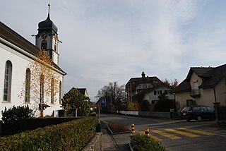
Religion
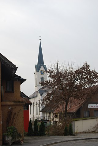
City Church of Mellingen
From the 2000 census[update], 1,961 or 46.3% are Roman Catholic, while 1,175 or 27.7% belonged to the Swiss Reformed Church. Of the rest of the population, there are 2 individuals (or about 0.05% of the population) who belong to the Christian Catholic faith.[9]
Birmenstorf is a municipality in the district of Baden in the canton of Aargau in Switzerland.
Ennetbaden is a municipality in the district of Baden in the canton of Aargau in Switzerland, located in the Limmat Valley.
Fischbach-Göslikon is a municipality in the district of Bremgarten in the canton of Aargau in Switzerland.
Fislisbach is a municipality in the district of Baden in the canton of Aargau in Switzerland.
Rudolfstetten-Friedlisberg is a municipality in the district of Bremgarten in the canton of Aargau in Switzerland. Prior to 1953, the municipality was officially known simply as Rudolfstetten.
Zufikon is a municipality in the district of Bremgarten in the canton of Aargau in Switzerland.
Oberrüti is a municipality in the district of Muri in the canton of Aargau in Switzerland.
Gebenstorf is a municipality in the district of Baden in the canton of Aargau in Switzerland.
Künten is a municipality in the district of Baden in the canton of Aargau in Switzerland. It lies on the Reuss River and includes the previously independent community of Sulz, which merged with Künten in 1973.
Mägenwil is a municipality in the district of Baden in the canton of Aargau in Switzerland.
Obersiggenthal is a municipality located in the Limmat Valley, within the district of Baden, in the canton of Aargau, Switzerland.
Remetschwil is a municipality in the district of Baden in the canton of Aargau in Switzerland.
Stetten is a municipality in the district of Baden in the canton of Aargau in Switzerland.
Untersiggenthal is a municipality in the district of Baden in the canton of Aargau in Switzerland, located in the Limmat Valley.
Wohlenschwil is a municipality in the district of Baden in the canton of Aargau in Switzerland.
Küttigen is a municipality in the district of Aarau of the canton of Aargau in Switzerland.
Niederwil is a municipality in the district of Bremgarten in the canton of Aargau in Switzerland.
Tägerig is a municipality in the district of Bremgarten in the canton of Aargau in Switzerland.
Birrhard is a municipality in the district of Brugg in canton of Aargau in Switzerland.
Zetzwil is a municipality in the district of Kulm in the canton of Aargau in Switzerland.
This page is based on this Wikipedia article Text is available under the CC BY-SA 4.0 license; additional terms may apply. Images, videos and audio are available under their respective licenses.