Miles City Airport

Last updated
Miles City Airport

Frank Wiley Field
Summary
Airport typePublic
OwnerMiles City
Serves Miles City, Montana
Elevation  AMSL 2,630 ft / 802 m
Coordinates 46°25′41″N105°53′10″W / 46.42806°N 105.88611°W / 46.42806; -105.88611
Map
USA Montana relief location map.jpg
Airplane silhouette.svg
MLS
Location in Montana
Usa edcp relief location map.png
Airplane silhouette.svg
MLS
Location in the United States
Runways
Direction LengthSurface
ftm
4/225,6801,731Asphalt
13/315,6281,715Asphalt
Statistics (2009)
Aircraft operations11,200
Based aircraft20
Sources: Airport [1] and FAA [2]

Miles City Airport [1] or Frank Wiley Field [2] ( IATA : MLS, ICAO : KMLS, FAA LID : MLS) is a city-owned airport two miles northwest of Miles City, in Custer County, Montana, United States. [2] The airport was served by one airline, subsidized by the Essential Air Service program. EAS subsidies ended on July 15, 2013, due to subsidy per passenger exceeding $1000, leaving Miles City without scheduled air service. [3]

Contents

Federal Aviation Administration records say the airport had 264 passenger boardings (enplanements) in calendar year 2008, [4] 891 in 2009 and 1,033 in 2010. [5] The National Plan of Integrated Airport Systems for 2011–2015 called it a general aviation airport (the commercial service category requires 2,500 enplanements per year). [6]

Scheduled air service temporarily ceased on March 8, 2008, when Big Sky Airlines ended operations in bankruptcy. Great Lakes Airlines was given USDOT approval to take over Essential Air Service (EAS) [7] and flights began in 2009. From 2011 to 2013, service had been provided under EAS contract by Silver Airways (formerly Gulfstream International Airlines).

Facilities

Frank Wiley Field covers 1,640 acres (2.56 sq mi; 6.6 km2) at an elevation of 2,630 feet (802 m) above sea level. It has two asphalt runways: 4/22 is 5,680 by 75 feet (1,731 by 23 m) and 13/31 is 5,628 by 100 feet (1,715 by 30 m). [2]

In 2009, the airport had 11,200 aircraft operations, average 30 per day: 71% general aviation and 29% air taxi. 20 aircraft were then based at this airport: 90% single-engine and 10% multi-engine. [2]

Historical airline service

The first known commercial air service to Miles City was provided by Mamer Air Transport in 1930. Mamer used Ford trimotor aircraft on a route between Spokane and Minneapolis/St. Paul making multiple stops.

Northwest Airlines then served Miles City as one of multiple stops along the carrier's mainline route between Seattle and Chicago from the early 1930s until 1954. The mainline route was extended eastward to New York and Washington D.C. by 1950. Northwest flew Lockheed Model 10 Electra followed by Douglas DC-3 aircraft for its service to Miles City.

Frontier Airlines (1950-1986) served the airport from 1954 until 1980 with flights to Billings and Bismarck. Some flights to Billings would continue onto Salt Lake City via multiple stops. Douglas DC-3 prop and Convair 580 turboprop aircraft were used. Combs Aviation also provided service to Miles City from 1968 through 1970 with Aero Commander 500 twin prop aircraft on behalf of Frontier via a contract agreement, [8] [9] and for a period in 1970, Frontier contracted all of its Miles City service to Combs. Combs then ended their contract service and Frontier returned in 1971 using de Havilland Canada DHC-6 Twin Otter turboprop aircraft.

Big Sky Airlines provided turboprop service to Billings from 1980 until 2008 using Fairchild Swearingen Metroliner commuter aircraft followed by Beech 1900D commuter aircraft.

Great Lakes Airlines flew from Miles City to Denver with one stop at Gillette, WY using Beech 1900D aircraft from 2008 through mid-2011. [7]

Silver Airways was the final carrier providing service to Billings from 2011 until all service ended on July 15, 2013, after government subsidies were cancelled due to a lack of passenger traffic. Silver also flew Beech 1900D aircraft. [10]

Accidents

See also

Related Research Articles

<span class="mw-page-title-main">Glasgow Valley County Airport</span> Airport

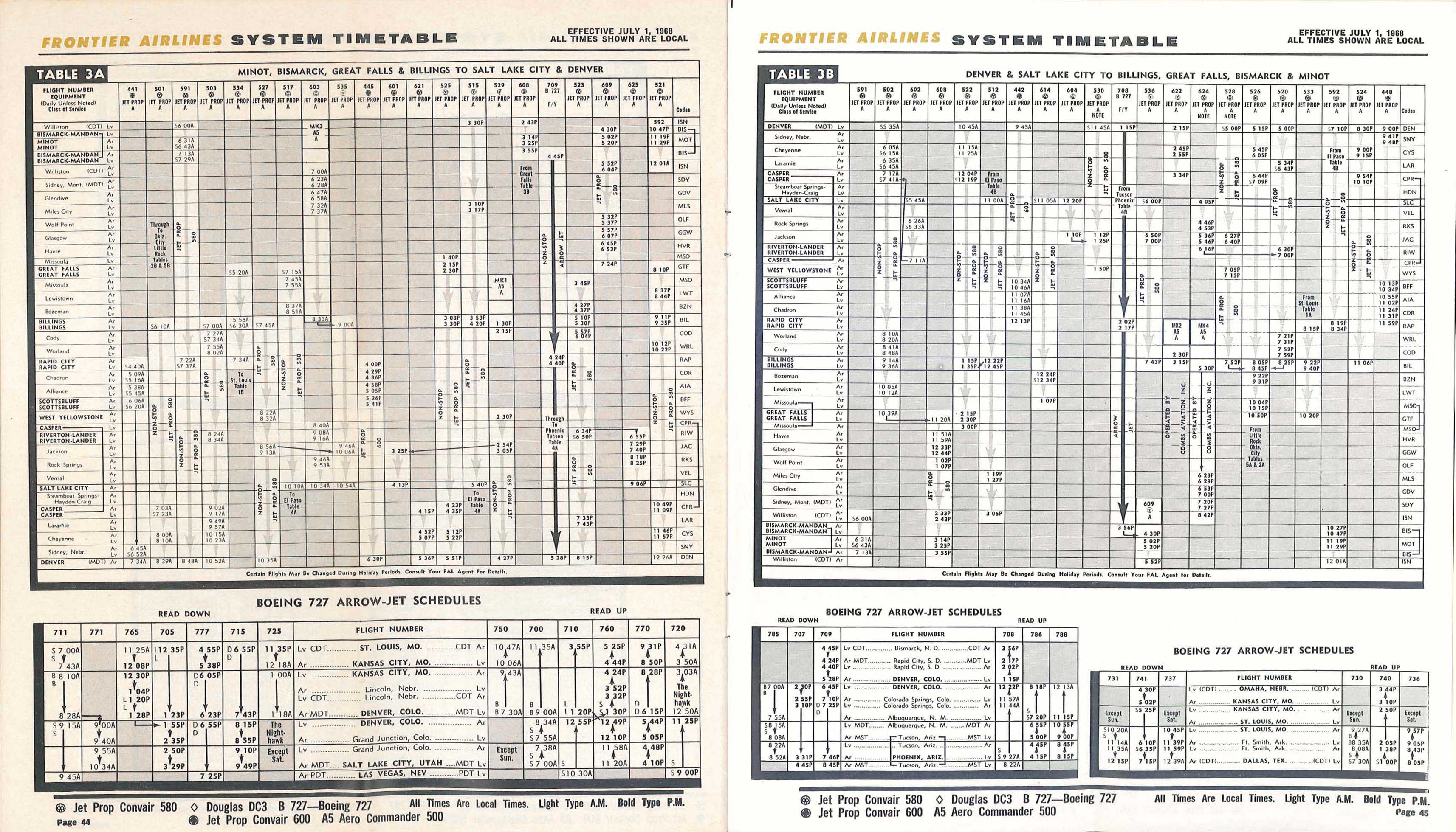
Glasgow Valley County Airport IATA: GGW, ICAO: KGGW, FAA LID: GGW) is a public airport a mile northeast of Glasgow, in Valley County, Montana, United States. It is served by one airline, subsidized by the Essential Air Service program.

Cortez Municipal Airport is three miles southwest of Cortez, in Montezuma County, Colorado, United States. It is served by one airline operating scheduled passenger service, Plane and crew by Key Lime Air DBA Denver Air Connection.

Sheridan County Airport is in Sheridan County, Wyoming, two miles southwest of Sheridan, Wyoming.

<span class="mw-page-title-main">Cedar City Regional Airport</span> Airport in Utah

Cedar City Regional Airport is two miles northwest of Cedar City, in Iron County, Utah. It is owned by the Cedar City Corporation. Airline flights are subsidized by the Essential Air Service program.

<span class="mw-page-title-main">Kearney Regional Airport</span> Airport in Buffalo County, Nebraska

Kearney Regional Airport is an airport five miles northeast of Kearney in Buffalo County, Nebraska. Denver Air Connection provides scheduled passenger service to Denver which is supported by the Essential Air Service.

Grant County Airport is a county-owned, public-use airport in Grant County, New Mexico, United States. It is located 10 nautical miles southeast of the central business district of Silver City, New Mexico. The airport is mostly used for general aviation, but is also served by one commercial airline. Service is subsidized by the Essential Air Service program.

Clovis Regional Airport is a city-owned, public-use airport located six nautical miles east of the central business district of Clovis, a city in Curry County, New Mexico, United States. The facility opened in April, 1959 and is mostly used for general aviation, but is also served by one commercial airline. Current scheduled passenger service is subsidized by the Essential Air Service program. The airport was previously known as Clovis Municipal Airport but underwent a name change to Clovis Regional Airport in 2021 when it was upgraded to Part 121 status.

<span class="mw-page-title-main">Waynesville-St. Robert Regional Airport</span> Airport in Fort Leonard Wood

Waynesville-St. Robert Regional Airport, also known as Forney Field, is a public and military use airport located at Fort Leonard Wood in Pulaski County, Missouri, United States. The airport's passenger terminal is operated under the control of the U.S. Army and general aviation is under the direction of a board named by the cities of Waynesville and St. Robert. Formerly known as Waynesville Regional Airport at Forney Field, it is served by one commercial airline with scheduled service subsidized by the Essential Air Service program.

<span class="mw-page-title-main">Watertown International Airport</span> Airport in Watertown, New York

Watertown International Airport is in the Town of Hounsfield in Jefferson County, New York, United States, 6 mi west of Watertown. The airport is used for general aviation, but has scheduled passenger service subsidized by the Essential Air Service program. The airport has no scheduled international passenger flights, but is available as an international port of entry for private aircraft on two hours' advance notice from pilots.

<span class="mw-page-title-main">Johnstown–Cambria County Airport</span> Airport

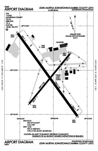
John Murtha Johnstown–Cambria County Airport is a civil-military airport three miles (5 km) northeast of Johnstown, in Cambria County, Pennsylvania. It is owned by Johnstown–Cambria County Airport Authority and is named after the late Congressman John Murtha. It sees one airline, subsidized by the Essential Air Service.

Dawson Community Airport is five miles northwest of Glendive, in Dawson County, Montana, United States. The airport has one airline, subsidized by the Essential Air Service program.

Havre City–County Airport is a public use airport located three nautical miles (6 km) west of the central business district of Havre, a city in Hill County, Montana, United States. It is owned by the City of Havre and Hill County. The airport is served by one commercial airline, subsidized by the Essential Air Service program.

<span class="mw-page-title-main">Lewistown Municipal Airport</span> Airport

Lewistown Municipal Airport is two miles southwest of Lewistown, in Fergus County, Montana. It is owned by the city and county.

<span class="mw-page-title-main">Sidney–Richland Municipal Airport</span> Airport

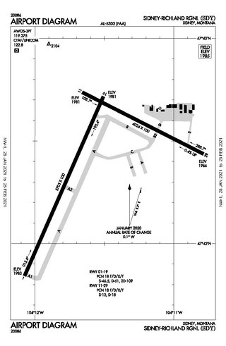
Sidney–Richland Municipal Airport is a mile west of Sidney, in Richland County, Montana, United States. The airport is served by one airline, subsidized by the federal government's Essential Air Service program at a cost of $3,777,579.

L. M. Clayton Airport is a public airport three miles east of Wolf Point, in Roosevelt County, Montana, United States. The airport is served by one airline, subsidized by the Essential Air Service program. Reportedly, it is the smallest airport in the 48 contiguous states with scheduled air service.

<span class="mw-page-title-main">Veterans Airport of Southern Illinois</span> Airport

Veterans Airport of Southern Illinois , also known as Williamson County Regional Airport, is five miles west of Marion, in Williamson County, Illinois, United States. The airport is owned by the Williamson County Airport Authority. It sees one airline, subsidized by the federal government's Essential Air Service program at an annual cost of $2,562,819 or $141 per passenger. On November 11, 2016 during the grand opening ceremony for the new terminal, the airport was renamed to "Veterans Airport of Southern Illinois" to honor veterans and better reflect the regional nature of the airport.

<span class="mw-page-title-main">Massena International Airport</span> Airport

Massena International Airport is in St. Lawrence County, New York. It is two nautical miles (3.7 km) east of the village of Massena. The airport sees one airline, subsidized by the Essential Air Service program.

<span class="mw-page-title-main">Ogdensburg International Airport</span> Public airport in Upstate New York

Ogdensburg International Airport is a public airport located in the town of Oswegatchie, 2 miles (3.2 km) southeast of Ogdensburg, in St. Lawrence County, New York. It is owned by the Ogdensburg Bridge & Port Authority, which also owns and operates the Ogdensburg–Prescott International Bridge, Port of Ogdensburg-Marine Terminal Facility, Commerce Park, Port of Waddington, a medium-heavy industrial park and two short line railroads. The Ogdensburg Bridge and Port Authority is a New York State public-benefit corporation. The international airport is just outside the city limits on NY 812. It is used for general aviation and commercial service. Scheduled commercial flights are operated by one airline: Contour Airlines.

<span class="mw-page-title-main">Alamogordo–White Sands Regional Airport</span> Airport

Alamogordo–White Sands Regional Airport is a city-owned public-use airport located four nautical miles southwest of the central business district of Alamogordo, a city in Otero County, New Mexico. It was formerly known as Alamogordo Municipal Airport and opened in late 1959.

<span class="mw-page-title-main">Brownwood Regional Airport</span> Airport

Brownwood Regional Airport is six miles north of Brownwood, in Brown County, Texas. The National Plan of Integrated Airport Systems for 2011–2015 categorized it as a general aviation facility. The 21st Cavalry Brigade of the III Corps, U.S. Army use the airport for training in Apache and Blackhawk helicopters.

References

  1. 1 2 "Miles City Airport (Frank Wiley Field)". Miles City government website. Retrieved September 8, 2009.
  2. 1 2 3 4 5 FAA Airport Form 5010 for MLS PDF . Federal Aviation Administration. Effective April 5, 2012.
  3. Falstad, Jan. Lewistown, Miles City losing airline subsidies, Billings Gazette, June 13, 2013, Retrieved 2013-06-13
  4. "Enplanements for CY 2008" (PDF, 1.0 MB). CY 2008 Passenger Boarding and All-Cargo Data. Federal Aviation Administration. December 18, 2009.
  5. "Enplanements for CY 2010" (PDF, 189 KB). CY 2010 Passenger Boarding and All-Cargo Data. Federal Aviation Administration. October 4, 2011.
  6. "2011–2015 NPIAS Report, Appendix A" (PDF). National Plan of Integrated Airport Systems. Federal Aviation Administration. October 4, 2010. Archived from the original (PDF, 2.03 MB) on September 27, 2012.
  7. 1 2 "Great Lakes prepares for Montana routes". Sidney Herald. Montana. December 30, 2007. Retrieved February 3, 2008.
  8. https://www.timetableimages.com/ttimages/fl/fl6807/fl6807-1.jpg
  9. https://www.timetableimages.com/ttimages/fl/fl6807/fl6807-4.jpg
  10. Official Airline Guide
  11. "Sergeant's quick thinking saves 11 lives in airliner crash". Spokane Daily Chronicle. (Washington). Associated Press. May 13, 1942. p. 1.
  12. "Save passengers but pilots die". Spokane Daily Chronicle. (Washington). Associated Press. May 13, 1942. p. 2.
  13. "Montana crash takes 5 lives". Spokane Daily Chronicle. (Washington). Associated Press. March 13, 1964. p. 2.

Other sources