
Crosby is a city in Crow Wing County, Minnesota, United States. The population was 2,386 at the 2010 census. It is part of the Brainerd Micropolitan Statistical Area. Crosby is adjacent to its twin city of Ironton, in the Cuyuna iron range.
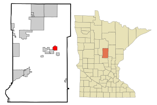
Cuyuna is a city in Crow Wing County, Minnesota, United States. The population was 332 at the 2010 census. It is part of the Brainerd Micropolitan Statistical Area.

The Mesabi Iron Range is a mining district in northeastern Minnesota following an elongate trend containing large deposits of iron ore. It is the largest of four major iron ranges in the region collectively known as the Iron Range of Minnesota. First described in 1866, it is the chief iron ore mining district in the United States. The district is located largely in Itasca and Saint Louis counties. It has been extensively worked since 1892, and has seen a transition from high-grade direct shipping ores through gravity concentrates to the current industry exclusively producing iron ore (taconite) pellets. Production has been dominantly controlled by vertically integrated steelmakers since 1901, and therefore is dictated largely by US ironmaking capacity and demand.
The Iron Range is collectively or individually a number of elongated iron-ore mining districts around Lake Superior in the United States and Canada. Much of the ore-bearing region lies alongside the range of granite hills formed by the Giants Range batholith. These cherty iron ore deposits are Precambrian in the Vermilion Range and middle Precambrian in the Mesabi and Cuyuna ranges, all in Minnesota. The Gogebic Range in Wisconsin and the Marquette Iron Range and Menominee Range in Michigan have similar characteristics and are of similar age. Natural ores and concentrates were produced from 1848 until the mid-1950s, when taconites and jaspers were concentrated and pelletized, and started to become the major source of iron production.

Vale S.A., formerly Companhia Vale do Rio Doce is a Brazilian multinational corporation engaged in metals and mining and one of the largest logistics operators in Brazil. Vale is the largest producer of iron ore and nickel in the world. It also produces manganese, ferroalloys, copper, bauxite, potash, kaolin, and cobalt, currently operating nine hydroelectricity plants, and a large network of railroads, ships, and ports used to transport its products.
The Vermilion Range exists between Tower, Minnesota and Ely, Minnesota, and contains significant deposits of iron ore. Together with the Mesabi and Cuyuna Ranges, these three constitute the Iron Ranges of northern Minnesota. While the Mesabi Range had iron ore close enough to the surface to enable pit mining, mines had to be dug deep underground to reach the ore of the Vermilion and Cuyuna ranges. The Soudan mine was nearly 1/2 mile underground and required blasting of Precambrian sedimentary bedrock.
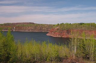
The Cuyuna Range is an inactive iron range to the southwest of the Mesabi Range, largely within Crow Wing County, Minnesota. It lies along a 68-mile-long (109 km) line between Brainerd, Minnesota, and Aitkin, Minnesota. The width ranges from 1 to 10 miles.

Cuyuna Country State Recreation Area (CCSRA) is a state park unit of Minnesota, USA, being developed to rehabilitate a portion of the Cuyuna Range where mining pits and piles of waste rock were left behind after decades of open-pit mining for iron ore. Abandoned by mining companies more than 20 years ago, the state recreation area consists of regenerated vegetation and clear lakes that draw a wide range of recreation enthusiasts. The park is located off Minnesota State Highway 210, near the towns of Crosby, Ironton and Cuyuna. The Croft Mine Historical Park, formerly city-run, is now part of the state recreation area.
The Cliffs Shaft Mine Museum is a former iron mine, now a heritage museum, located on Euclid Street between Lakeshore Drive and Spruce Street in Ishpeming, Michigan. The museum, operated by "Marquette Range Iron Mining Heritage Theme Park Inc.", celebrates the history of the Marquette Iron Range. The site was designated a state of Michigan historic site in 1973 and placed on the National Register of Historic Places in 1992.

The Hull–Rust–Mahoning Open Pit Iron Mine in Hibbing, Minnesota, United States, is the largest operating open-pit iron mine in Minnesota. The pit stretches more than three miles (5 km) long, two miles (3 km) wide, and 535 feet (163 m) deep. It was established in 1895 and was one of the world's first mechanized open-pit mines.

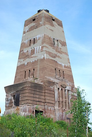
The Cuyuna Iron Range Municipally-Owned Elevated Metal Water Tanks are a group of five water towers within the Cuyuna Range in Crow Wing County, Minnesota. The water tanks, built between 1912 and 1918, were listed on the National Register of Historic Places because they represent the historical period of community planning, public works, and engineering that supported the development of the Cuyuna Range. Their construction was made possible by a favorable property tax arrangement on the iron mines that brought significant revenues to the towns of Crosby, Cuyuna, Deerwood, Ironton, and Trommald. The communities began around 1910, when iron mining started on the Range. The peak of mining employment was around 1920, and it started to decline around 1930. By the 1950s, iron mining was well in decline on the Cuyuna Range. As of 2022, it appears only two of the water tanks survive at their original locations.

Crosby station is a historic former train station in Crosby, Minnesota, United States. It was established in 1910. It was listed on the National Register of Historic Places in 1980 as the Crosby Railroad Depot for having local significance in the themes of commerce, industry, and transportation. The depot was nominated for being an essential conduit for the arrival of goods and people and the export of iron ore during central Crow Wing County's economic boom years.
Mountain Iron Mine is a former mine in Mountain Iron, Minnesota, United States. Opened in 1892, it was the first mine on the Mesabi Range, which has proved to be the largest iron ore deposit ever discovered in the United States. Mining operations at the site ceased in 1956. The bottom of the open-pit mine has filled with water but its dimensions are readily visible. The city maintains an overlook in Mountain Iron Locomotive Park.

Manganese is a ghost town and former mining community in the U.S. state of Minnesota that was inhabited between 1912 and 1960. It was built in Crow Wing County on the Cuyuna Iron Range in sections 23 and 28 of Wolford Township, about 2 miles (3 km) north of Trommald, Minnesota. After its formal dissolution, Manganese was absorbed by Wolford Township; the former town site is located between Coles Lake and Flynn Lake. First appearing in the U.S. Census of 1920 with an already dwindling population of 183, the village was abandoned by 1960.

The Jackson Mine is an open pit iron mine in Negaunee, Michigan, extracting resources from the Marquette Iron Range. The first iron mine in the Lake Superior region, Jackson Mine was designated as a Michigan State Historic Site in 1956 and listed on the National Register of Historic Places in 1971. The Lake Superior Mining Institute said, the mine "is attractive in the iron ore region of Michigan and the entire Lake Superior region, because of the fact it was here that the first discovery of iron ore was made, here the first mining was done, and from its ore the first iron was manufactured." Multiple other mines soon followed the Jackson's lead, establishing the foundation of the economy of the entire region. The mine is located northwest of intersection of Business M-28 and Cornish Town Road.

Ironton Sintering Plant Complex is a group of buildings north of Crosby, Minnesota, United States, listed on the National Register of Historic Places. The plant was built in 1924 by the Hanna Mining Company to sintering iron ore mined in the Cuyuna Range. The mining industry, after 1900, was seeking to exploit lower-grade iron deposits to meet the increasing demand of the iron and steel industry. To bring the ore to customers' specifications, the mines sought to "beneficiate" the ore through sintering, crushing, and washing. The sintering process was unique to the Cuyuna Range and made it possible to economically support mining.
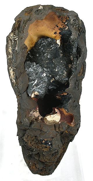
Groutite is a manganese oxide mineral with formula Mn3+O(OH). It is a member of the diaspore group and is trimorphous with manganite and feitknechtite. It forms lustrous black crystals in the orthorhombic system.
The Oliver Iron Mining Company was a mining company operating in Minnesota, United States. It was one of the most prominent companies in the early decades of mining on the Mesabi Range. As a division of U.S. Steel, Oliver dwarfed its competitors—in 1920, it operated 128 mines across the region, while its largest competitor operated only 65.
The Cuyuna Range mine is a mine located in the north of the United States in Minnesota. Cuyuna Range represents one of the largest manganese reserve in the United States having estimated reserves of 247 million tons of manganese ore grading 8% manganese metal.
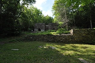
Mine Hills Preserve is a natural and historical conservation area on Mine Hills Road in northwestern Roxbury, Connecticut. Owned by the Roxbury Land Trust, it protects the site of a well-preserved 19th-century iron mine and furnace works. Several miles of trails provide access to abandoned quarry areas and the preserved remains of the iron works, whose uses are explained by informational panels. The preserve is open from dawn to dusk. The 360-acre (150 ha) preserve was listed on the National Register of Historic Places in 1979.


