Millwood, Washington

Last updated

Millwood
Millwood City Hall.png
Spokane County Washington Incorporated and Unincorporated areas Millwood Highlighted.svg
Location of Millwood, Washington
Coordinates: 47°41′8″N117°17′3″W / 47.68556°N 117.28417°W / 47.68556; -117.28417
Country United States
State Washington
County Spokane
Area
[1]
  Total0.70 sq mi (1.82 km2)
  Land0.70 sq mi (1.80 km2)
  Water0.01 sq mi (0.01 km2)
Elevation
1,972 ft (601 m)
Population
 (2010) [2]
  Total1,786
  Estimate 
(2019) [3]
1,800
  Density2,586.21/sq mi (998.38/km2)
Time zone UTC-8 (Pacific (PST))
  Summer (DST) UTC-7 (PDT)
ZIP code
99212
Area code 509
FIPS code 53-45985
GNIS feature ID1512466 [4]
Website millwoodwa.us

Millwood is a city in Spokane County, Washington, United States. The population was 1,786 at the 2010 census. Millwood is a suburb of Spokane, and is surrounded on three sides by the city of Spokane Valley. The Spokane River flows along the northern edge of the city. The city is home to the National Register of Historic Places listed Millwood Historic District.

Contents

Government

The city government is organized using the Mayor-Council form. The mayor as of November 2022 is Kevin Freeman, who was first elected in November 2013 and took office in January 2014. In November 2017, he was elected to his second term. Freeman is simultaneously a member of the board of directors for the Spokane Regional Health District, and the Spokane Regional Clean Air Agency. The city council consists of five members, who are elected to serve terms of four years. [5]

History

The Inland Empire Paper Company facility in Millwood, the town's namesake Millwood8.png
The Inland Empire Paper Company facility in Millwood, the town's namesake

Millwood was officially incorporated on October 26, 1927. It was named for the local sawmill. [6]

According to the Tacoma Public Library's Washington Place Names database: "In 1900, it was chosen as a station by the Spokane-Coeur d'Alene Electric Railway, and was named Woodard's for the family who owned the land along the railway route. When Inland Empire Paper Company built a paper mill they requested a name change to Milltown. Railway officials refused the change unless the Woodard family agreed. A compromise resulted, using the word mill combined with the first four letters of Woodard. It was incorporated October 27, 1927." [7]

The Rosebush House, located in the center of Millwood, "is one of Millwood's best preserved homes" and is listed on the U.S. National Register of Historic Places. [8]

Geography

Dalton Avenue is one of Millwood's many tree-lined streets. Millwood Dalton Ave.png
Dalton Avenue is one of Millwood's many tree-lined streets.

Millwood is located at 47°41′8″N117°17′3″W / 47.68556°N 117.28417°W / 47.68556; -117.28417 (47.685693, -117.284297). [9]

According to the United States Census Bureau, the town has a total area of 0.73 square miles (1.89 km2), of which, 0.70 square miles (1.81 km2) is land and 0.03 square miles (0.08 km2) is water. [10]

The topography of the city is mostly flat as it lies on the floor of the Spokane Valley, though it does slope gently down towards the north. The northern edge of town is defined by the Spokane River, where the terrain promptly drops about 20 feet down to the river bank.

Two major arterials pass through Millwood. Argonne Road bisects the city before crossing the Spokane River, providing the only river crossing for automobiles between Greene Street in Spokane, five miles to the west, and Trent Avenue three miles to the east. Trent Avenue, carrying Washington State Route 290, marks the southern limit of the city. The intersection of Argonne and Trent is home to a shopping center. The Argonne exit of Interstate 90 is located half-a-mile south of Millwood.

West Valley High School, which serves Millwood and surrounding areas, [11] is located on the western boundary of the town.

Climate

This region experiences warm (but not hot) and dry summers, with no average monthly temperatures above 71.6 °F. According to the Köppen Climate Classification system, Millwood has a warm-summer Mediterranean climate, abbreviated "Csb" on climate maps. [12]

Demographics

Historical population
CensusPop.Note
1930 493
1940 71745.4%
1950 1,24072.9%
1960 1,77643.2%
1970 1,770−0.3%
1980 1,717−3.0%
1990 1,559−9.2%
2000 1,6495.8%
2010 1,7868.3%
2020 1,8815.3%
U.S. Decennial Census [13]

2010 census

As of the 2010 census, [2] there were 1,786 people, 751 households, and 467 families living in the town. The population density was 2,551.4 inhabitants per square mile (985.1/km2). There were 793 housing units at an average density of 1,132.9 per square mile (437.4/km2). The racial makeup of the town was 94.4% White, 0.6% African American, 1.3% Native American, 1.1% Asian, 0.3% Pacific Islander, 0.6% from other races, and 1.7% from two or more races. Hispanic or Latino of any race were 1.9% of the population.

There were 751 households, of which 30.2% had children under the age of 18 living with them, 46.2% were married couples living together, 11.2% had a female householder with no husband present, 4.8% had a male householder with no wife present, and 37.8% were non-families. 31.2% of all households were made up of individuals, and 10.8% had someone living alone who was 65 years of age or older. The average household size was 2.37 and the average family size was 2.94.

The median age in the town was 40.1 years. 22.6% of residents were under the age of 18; 7.3% were between the ages of 18 and 24; 27.5% were from 25 to 44; 29.6% were from 45 to 64; and 13% were 65 years of age or older. The gender makeup of the town was 49.8% male and 50.2% female.

2000 census

As of the 2000 census, there were 1,649 people, 741 households, and 457 families living in the town. The population density was 2,395.7 inhabitants per square mile (922.7/km2). There were 779 housing units at an average density of 1,131.7 per square mile (435.9/km2). The racial makeup of the town was 95.27% White, 0.55% African American, 0.42% Native American, 1.03% Asian, 0.12% Pacific Islander, 0.49% from other races, and 2.12% from two or more races. Hispanic or Latino of any race were 1.46% of the population.

There were 741 households, out of which 24.2% had children under the age of 18 living with them, 46.7% were married couples living together, 10.9% had a female householder with no husband present, and 38.2% were non-families. 31.2% of all households were made up of individuals, and 12.1% had someone living alone who was 65 years of age or older. The average household size was 2.23 and the average family size was 2.79.

In the town the population was spread out, with 20.8% under the age of 18, 7.9% from 18 to 24, 30.1% from 25 to 44, 25.3% from 45 to 64, and 15.9% who were 65 years of age or older. The median age was 40 years. For every 100 females, there were 93.5 males. For every 100 females age 18 and over, there were 91.8 males.

The median income for a household in the town was $34,565, and the median income for a family was $40,441. Males had a median income of $31,292 versus $22,500 for females. The per capita income for the town was $17,911. About 8.0% of families and 11.0% of the population were below the poverty line, including 18.2% of those under age 18 and 5.6% of those age 65 or over.

Related Research Articles

<span class="mw-page-title-main">Post Falls, Idaho</span> City in Idaho, United States

Post Falls is a city in Kootenai County, Idaho, United States. It is the gateway city to North Idaho on I-90 just west of Coeur d'Alene and east of Spokane, Washington. The population was 38,485 at the 2020 census, making it Idaho's ninth-largest city and the second largest city in North Idaho behind Coeur d’Alene.

<span class="mw-page-title-main">Priest River, Idaho</span> City in Idaho, United States

Priest River is a city in Bonner County, Idaho. The population was 1,696 at the 2020 census, and 1,751 at the 2010 census. Located in the Idaho Panhandle region of the state, the city is at the mouth of the Priest River on the Pend Oreille River.

<span class="mw-page-title-main">Arco, Idaho</span> City in Idaho, United States

Arco is a city in Butte County, Idaho, United States. The population was 879 as of the 2020 United States census, down from 995 at the 2010 census. Arco is the county seat and largest city in Butte County.

<span class="mw-page-title-main">Stites, Idaho</span> City in Idaho, United States

Stites is a city in Idaho County, Idaho, United States. In the lower canyon of the South Fork of the Clearwater River, it is about four miles (6 km) upstream and south of Kooskia on State Highway 13. The population was 221 at the 2010 census, down from 226 in 2000.

<span class="mw-page-title-main">Stateline, Idaho</span> City in Idaho, United States

Stateline, officially the City of State Line, and historically known as State Line Village, is a city in Kootenai County, Idaho, United States, and is both the easternmost suburb of Spokane, Washington and the westernmost suburb of Coeur d'Alene, Idaho. The population was 39 at the 2020 census. The city is known for the adult services it provides which attract business from nearby Spokane and Coeur d'Alene. The unincorporated community of Spokane Bridge, Washington is located across the Spokane River to the southwest.

<span class="mw-page-title-main">Deary, Idaho</span> City in Idaho, United States

Deary is a city in Latah County, Idaho. The population was 506 at the time of the 2010 census, down from 552 in 2000. It is located 24 miles (39 km) east of Moscow and 43 miles (69 km) northeast of Lewiston.

<span class="mw-page-title-main">Spokane, Missouri</span> Census-designated place in Missouri, United States

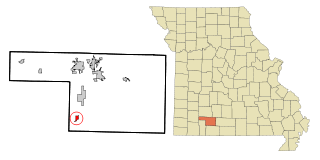
Spokane is a census-designated place in Christian County, Missouri, United States. The population was 177 at the 2010 census. It is part of the Springfield, Missouri, Metropolitan Statistical Area.

<span class="mw-page-title-main">New Castle, New York</span> Town in New York, United States

New Castle is a town in Westchester County, New York, United States. The population was 18,311 in the 2020 United States census, an increase over 17,569 at the 2010 census. It includes the named hamlets of Chappaqua and Millwood, but residents and businesses in the Town of New Castle can also have a designated city address of Ossining, or Millwood as well as Chappaqua or even Mt. Kisco.

<span class="mw-page-title-main">Lake Aluma, Oklahoma</span> Town in Oklahoma, United States

Lake Aluma is a town in Oklahoma County, Oklahoma, United States, and a part of the Oklahoma City Metropolitan Area. The population was 88 at the 2010 census.

<span class="mw-page-title-main">Oroville, Washington</span> City in Washington, United States

Oroville is a city located in the northern bulk of the Okanogan Highlands in north-central Washington, United States. Oroville is a member municipality of Okanogan County, Washington, situated between Omak and Penticton. The population was 1,795 at the 2020 census.

<span class="mw-page-title-main">Fairfield, Washington</span> Town in Washington, United States

Fairfield is a town in Spokane County, Washington, United States. The population was 589 at the 2020 census.

<span class="mw-page-title-main">Latah, Washington</span> Town in Washington, United States

Latah is a town in Spokane County, Washington, United States. The population was 185 at the 2020 census. It was named for the nearby creek, Latah Creek, from the native word for fish. The town was formerly called, Hangman's Creek and Alpha.

<span class="mw-page-title-main">Medical Lake, Washington</span> City in Washington, United States

Medical Lake is a small city in Spokane County, eastern Washington, United States. At the 2020 census, the population was 4,874. The city is the site of a psychiatric hospital, Eastern State Hospital, and of Fairchild Air Force Base, two major employers.

<span class="mw-page-title-main">Rockford, Washington</span> Town in Washington, United States

Rockford is a town in Spokane County, Washington, United States. The population was 522 at the 2020 census.

<span class="mw-page-title-main">Spangle, Washington</span> City in Washington, United States

Spangle is a city in Spokane County, Washington, United States. The population was 278 at the 2010 census. The name comes from William Spangle, an early pioneer.

<span class="mw-page-title-main">Veradale, Washington</span> Locale in Washington, United States

Veradale—originally known as Vera—is a locale and former census-designated place in Spokane County, Washington, United States. The population was 9,387 at the 2000 census. Veradale retains its own post office.

<span class="mw-page-title-main">Lamont, Washington</span> Town in Washington, United States

Lamont is a town in Whitman County, Washington, United States. The population was 79 at the 2020 census.

<span class="mw-page-title-main">Glasgow, West Virginia</span> Town in West Virginia, United States

Glasgow is a town in Kanawha County, West Virginia, United States, situated along the Kanawha River. The population was 708 at the 2020 census. Glasgow was incorporated on June 20, 1920. Folk etymology derives its name from a combination of the word "glass" with the word "company" for a glass factory that was built there many years ago, but the presence of many Scottish immigrants to this part of Appalachia, particularly from the Strathclyde region, indicates that the town was most likely named after the Scottish city of Glasgow in Strathclyde. Other Virginia and West Virginia locations named for places in Strathclyde include Dumbarton, Argyle, Loudoun County, Hamilton in Loudoun County, Lanark and Renfrew.

<span class="mw-page-title-main">Belmont, West Virginia</span> Town in West Virginia, United States

Belmont is a town in Pleasants County, West Virginia, United States. It is part of the Parkersburg–Vienna metropolitan area. The population was 872 at the 2020 census. Belmont was incorporated on April 19, 1946, by the Circuit Court of Pleasants County. The city was named for the beautiful hills in the area.

<span class="mw-page-title-main">Argonne, Wisconsin</span> Town in Wisconsin, United States

Argonne is a town in Forest County, Wisconsin, United States. The population was 512 at the 2010 census. The census-designated place of Argonne is located in the town. The unincorporated community of Wisconsin Junction is also located in the town.

References

  1. "2019 U.S. Gazetteer Files". United States Census Bureau. Retrieved August 7, 2020.
  2. 1 2 "U.S. Census website". United States Census Bureau . Retrieved December 19, 2012.
  3. "Annual Estimates of the Resident Population for Incorporated Places in Washington: April 1, 2010 to July 1, 2019". United States Census Bureau. May 2020. Retrieved May 27, 2020.
  4. "US Board on Geographic Names". United States Geological Survey. October 25, 2007. Retrieved January 31, 2008.
  5. "City of Millwood". cityofmillwood.org. Retrieved October 29, 2018.
  6. Sullivan, Julie (March 16, 1989). "Architect builds historical interest with trivia". Spokane Chronicle. pp. S9. Retrieved May 2, 2015.
  7. Washington Place Names
  8. Linda Yeomans (April 19, 2000). "National Register of Historic Places Registration: Rosebush House". and accompanying photos
  9. "US Gazetteer files: 2010, 2000, and 1990". United States Census Bureau. February 12, 2011. Retrieved April 23, 2011.
  10. "US Gazetteer files 2010". United States Census Bureau. Archived from the original on January 25, 2012. Retrieved December 19, 2012.
  11. https://1.cdn.edl.io/wWTVRQoQGdBvV1jD4ENLojgMcwZHKSaDxinoo0Wh5o9YF195.pdf [ bare URL PDF ]
  12. "Millwood, Washington Köppen Climate Classification (Weatherbase)". Weatherbase.
  13. United States Census Bureau. "Census of Race" . Retrieved November 6, 2022.