Milton Park, Montreal

Last updated
Milton Park
Street of the Ghetto McGill, Montreal 2005-08-30.jpg
Aylmer looking north from the corner with Milton, in August.
Montreal-blank.png
Red pog.svg
Milton Park
Location of Milton Park in Montreal
Coordinates: 45°30′30″N73°34′29″W / 45.5083°N 73.5747°W / 45.5083; -73.5747
Country Canada
Province Quebec
City Montreal
Borough Le Plateau-Mont-Royal
Area
  Total0.52 km2 (0.20 sq mi)
  Land0.52 km2 (0.20 sq mi)
Population
  Total10,948
  Density21,000/km2 (55,000/sq mi)
Postal Code
H2X
Area code(s) 514, 438

Milton Park (French : Milton-Parc), commonly known as the McGill Ghetto , is a neighbourhood in Montreal, Quebec, Canada. It is situated directly to the east of the McGill University campus in the borough of Plateau-Mont-Royal. It is named after the neighbourhood's two main streets, Milton Street and Park Avenue. Many McGill students live in this area, which is characterized by a mix of rowhouses and low- to mid-rise apartment buildings. The area is roughly bordered by University Street and the university campus to the west, Sherbrooke Street to the south, Pine Avenue to the north, and Park Avenue and the Lower Plateau neighbourhood to the east, though McGill University considers this area to extend as far east as Saint Laurent Boulevard or just short of Saint-Louis Square.

Contents

The neighbourhood has many historic townhouses built in the late 19th century, which housed affluent businessmen and their families. The area remained a wealthy enclave throughout the early half of the 20th century. Eventually, many of the affluent residents of the area moved to other boroughs such as Westmount or to the suburbs.

While the space is colloquially known as the "Ghetto", the name for the area is used with the original definition of the word "ghetto": an inner-city neighbourhood segregated from the rest of the population. The McGill Ghetto's population mostly consists of monolingual students coming from other Canadian provinces and English speaking foreign students who tend to stay in the "Ghetto" and avoid mixing with the local francophone population. The word "ghetto" is thus used ironically because this area is not segregated due to economic pressure but because its population chooses to isolate itself from the rest of the city due to cultural and linguistic barriers. There is a movement against this nomenclature because it suggests that the area is completely inhabited by extra-provincial anglophone students, while it is also home to many families, working professionals and long-term residents. Montreal's historic Jewish "Ghetto" coincides in part with the present student Ghetto, meeting at the intersection of Duluth and Saint Laurent. [5]

The area has many small businesses catering to the needs of the local McGill community including The Word Bookstore, Café Lola Rosa, and several small convenience stores, as well as many "third place" hangouts. [6]

Development and preservation

Marlborough Apartments Montreal Les appartements Marlborough.jpg
Marlborough Apartments

In the 1970s, community activists were concerned that the vast La Cité mixed-use complex (consisting of apartments, offices, a mall, and a hotel - now McGill's New Residence) would destroy the neighbourhood's character. [7] A campaign to stop further redevelopment was led by a residents' coalition and the then-newly formed historic preservation group Heritage Montreal. [8]

When McGill University acquired the hotel component of La Cité (at Park and Prince Arthur) and transformed it into an undergraduate student residence (called New Residence Hall), the student population in Milton Park increased by 650 people. La Cité also has a gym Club La Cité with an outdoor pool open year long and crosstraining facilities. [9] In 2009, McGill University purchased a second hotel (Four-Points on Sherbrooke) and transformed it into another student residence for use starting in the 2009-2010 school year. [10]

Exhibitions

See also

Related Research Articles

<span class="mw-page-title-main">Notre-Dame-de-Grâce</span> Neighbourhood in Montreal, Quebec, Canada

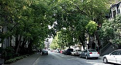
Notre-Dame-de-Grâce, also nicknamed NDG, is a residential neighbourhood of Montreal in the city's West End, with a population of 166,520 (2016). An independent municipality until annexed by the City of Montreal in 1910, NDG is today one half of the borough of Côte-des-Neiges–Notre-Dame-de-Grâce. It comprises two wards, Loyola to the west and Notre-Dame-de-Grâce to the east. NDG is bordered by four independent enclaves; its eastern border is shared with the City of Westmount, Quebec, to the north and west it is bordered by the cities of Montreal West, Hampstead and Côte-Saint-Luc. NDG plays a pivotal role in serving as the commercial and cultural hub for Montreal's predominantly English-speaking West End, with Sherbrooke Street West running the length of the community as the main commercial artery. The community is roughly bounded by Claremont Avenue to the east, Côte-Saint-Luc Road to the north, Brock Avenue in the west, and Highway 20 and the Saint-Jacques Escarpment to the south.

<span class="mw-page-title-main">Sherbrooke</span> City in Quebec, Canada

Sherbrooke is a city in southern Quebec, Canada. It is at the confluence of the Saint-François and Magog rivers in the heart of the Estrie administrative region. Sherbrooke is also the name of a territory equivalent to a regional county municipality (TE) and census division (CD) of Quebec, coextensive with the city of Sherbrooke. With 172,950 residents at the Canada 2021 Census, it is the sixth largest city in the province and the 30th largest in Canada. The Sherbrooke Census Metropolitan Area had 227,398 inhabitants, making it the fourth largest metropolitan area in Quebec and 19th in Canada.

<span class="mw-page-title-main">North Glengarry</span> Township in Ontario, Canada

North Glengarry is a township in eastern Ontario, Canada, in the United Counties of Stormont, Dundas and Glengarry. It is a predominantly rural area located between Ottawa-Gatineau, Montreal and Cornwall.

<span class="mw-page-title-main">L'Île-Bizard, Quebec</span> Former city in Quebec, Canada

L'Île-Bizard is a former municipality current borough located on Île Bizard, an island northwest of the Island of Montreal. It was originally incorporated as a municipality on 1 July 1855 as Paroisse de Saint-Raphael-de l'Ile-Bizard.

<span class="mw-page-title-main">Griffintown</span> Neighbourhood in Montreal, Quebec, Canada

Griffintown is a historic neighbourhood of Montreal, Quebec, southwest of downtown. The area existed as a functional neighbourhood from the 1820s until the 1960s, and was mainly populated by Irish immigrants and their descendants. Mostly depopulated since then, the neighbourhood has been undergoing redevelopment since the early 2010s.

<span class="mw-page-title-main">Hull—Aylmer</span> Federal electoral district in Quebec, Canada

Hull—Aylmer is a federal electoral district in Quebec, Canada, that has been represented in the House of Commons of Canada since 1917.

<span class="mw-page-title-main">Ville-Marie, Montreal</span> Borough of Montreal in Quebec, Canada

Ville-Marie is the name of a borough (arrondissement) in the centre of Montreal, Quebec. The borough is named after Fort Ville-Marie, the French settlement that would later become Montreal, which was located within the present-day borough. Old Montreal is a National Historic Site of Canada.

<span class="mw-page-title-main">Chinatown, Montreal</span> Neighbourhood in Montreal, Quebec, Canada

Chinatown in Montreal is located in the area of De la Gauchetière Street in Montreal. The neighbourhood contains many Asian restaurants, food markets, and convenience stores as well being home to many of Montreal's East Asian community centres, such as the Montreal Chinese Hospital and the Montreal Chinese Community and Cultural Centre.

<span class="mw-page-title-main">Le Plateau-Mont-Royal</span> Borough of Montreal in Quebec, Canada

Le Plateau-Mont-Royal is a borough (arrondissement) of the city of Montreal, Quebec, Canada.

<span class="mw-page-title-main">Bells Corners</span> Community in Ontario, Canada

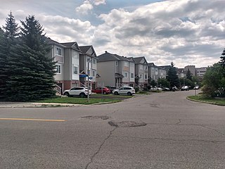
Bells Corners is a suburban neighbourhood in Ottawa, Ontario, Canada. It is located along Robertson Road west of downtown, within Ottawa's western Greenbelt, in College Ward. As of the Canada 2016 Census, the community had a population of 9,272.

<span class="mw-page-title-main">Downtown Montreal</span> Neighbourhood, central business district of Montreal in Quebec, Canada

Downtown Montreal is the central business district of Montreal, Quebec, Canada.

<span class="mw-page-title-main">Little Portugal, Montreal</span> Neighbourhood in Montreal, Quebec, Canada

Little Portugal is a neighbourhood in Montreal, Quebec, Canada. It is situated in the western portion of the borough of Le Plateau Mont-Royal.

<span class="mw-page-title-main">Montreal</span> Largest city in Quebec, Canada

Montreal is the second most populous city in Canada, the tenth most populous city in North America, and the most populous city in the province of Quebec. Founded in 1642 as Ville-Marie, or "City of Mary", it is named after Mount Royal, the triple-peaked hill around which the early city of Ville-Marie was built. The city is centred on the Island of Montreal, which obtained its name from the same origin as the city, and a few much smaller peripheral islands, the largest of which is Île Bizard. The city is 196 km (122 mi) east of the national capital Ottawa, and 258 km (160 mi) southwest of the provincial capital, Quebec City.

<span class="mw-page-title-main">Park Extension</span> Neighbourhood in Montréal, Québec, Canada

Park Extension is a neighbourhood in the city of Montréal, Québec. It is located in the borough of Villeray–Saint-Michel–Parc-Extension and has a population of 33,800 and an area of 1.6 km². The name derives from the fact that it is situated at the north end of Park Avenue and is literally an "extension" of the artery. The area is known by locals as "Park Ex."

<span class="mw-page-title-main">Sherbrooke Street</span> Street in Montreal, Canada

Sherbrooke Street is a major east–west artery and at 31.3 kilometres (19.4 mi) in length, is the second longest street on the Island of Montreal, Canada. The street begins in the town of Montreal West and ends on the extreme tip of the island in Pointe-aux-Trembles, intersecting Gouin Boulevard and joining up with Notre-Dame Street. East of Cavendish Boulevard this road is part of Quebec Route 138.

<span class="mw-page-title-main">Little Burgundy</span> Neighbourhood in Montreal, Quebec, Canada

Little Burgundy is a neighbourhood in the South West borough of the city of Montreal, Quebec, Canada.

<span class="mw-page-title-main">Goose Village</span> Former Neighborhood of Montreal in Quebec, Canada

Goose Village was a neighbourhood in Montreal, Quebec, Canada. Its official but less commonly used name was Victoriatown, after the adjacent Victoria Bridge. The neighbourhood was built on an area formerly known as Windmill Point, where thousands of Irish immigrants died from disease in 1847 and 1848. The entire neighborhood was demolished in 1964 as part of preparations for Expo 67, to be replaced by a football stadium and parking lot.

Dimitrios I. Roussopoulos is a Canadian political activist and publisher.

<span class="mw-page-title-main">Central Park, Ottawa</span> Neighbourhood in Ottawa, Ontario, Canada

Central Park is a neighbourhood in River Ward in the west end of Ottawa, Ontario, Canada. It is bounded on the east by Merivale Road, on the south by Baseline Road, on the west by Clyde Avenue and on the north by the Carlington neighbourhood. The population of the neighbourhood in 2016 was 3,888 in an area of 0.91 km2. It more than doubled its population between 2001 and 2006 as the neighbourhood expanded. Excluding the residences south of Baseline which are included in the Census Tract, the population of the neighbourhood is 3,760.

References

  1. 1 2 "4620130.00 [Census tract], Quebec and Montréal, TÉ [Census division], Quebec (table)" (Statistics Canada Catalogue no. 98-316-X2016001). Canada 2016 Census . Ottawa: Statistics Canada. 2017-11-29. Retrieved 31 December 2018.
  2. 1 2 "4620131.00 [Census tract], Quebec and Montréal, TÉ [Census division], Quebec (table)" (Statistics Canada Catalogue no. 98-316-X2016001). Canada 2016 Census . Ottawa: Statistics Canada. 2017-11-29. Retrieved 31 December 2018.
  3. 1 2 "4620131.00 [Census tract], Quebec and Montréal, TÉ [Census division], Quebec (table)" (Statistics Canada Catalogue no. 98-316-X2016001). Canada 2016 Census . Ottawa: Statistics Canada. 2017-11-29. Retrieved 31 December 2018.
  4. "Milton-Parc What/Where is Milton Parc?". SSMU External Affairs. Students' Society of McGill University. 18 October 2017. Retrieved 31 December 2018.
  5. Foran, Charles. Mordecai: The Life and Times. Toronto: Random House of Canada, 2010, p. 36.
  6. Askren, Hana (2007). "The rhythm of student life". Montreal Magazine.
  7. Gravenor, Kristian (2008-02-26). "Dashed projects". Coolopolis. Retrieved 2008-02-26.
  8. John Pierce, Ann Dale, ed. (2000-05-01). Communities, Development, and Sustainability Across Canada. UBC Press. p. 20. ISBN   0-7748-0722-9.
  9. "Residence Renaissance" Archived 2011-06-11 at the Wayback Machine , "McGill News", Summer 2003. Accessed October 18, 2010.
  10. "McGill acquires Four Points" Archived 2010-12-18 at the Wayback Machine , "McGill Daily", March 9, 2009. Accessed October 18, 2010.

Further reading