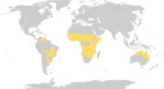
Tropical and subtropical grasslands, savannas, and shrublands is a terrestrial biome defined by the World Wide Fund for Nature. The biome is dominated by grass and/or shrubs located in semi-arid to semi-humid climate regions of subtropical and tropical latitudes. Tropical grasslands are mainly found between 5 degrees and 20 degrees in both North and south of the Equator.

Acacia aneura, commonly known as mulga or true mulga, is a shrub or small tree native to arid outback areas of Australia. It is the dominant tree in the habitat to which it gives its name (mulga) that occurs across much of inland Australia. Specific regions have been designated the Western Australian mulga shrublands in Western Australia and Mulga Lands in Queensland.

The Llanos is a vast tropical grassland plain situated to the east of the Andes in Colombia and Venezuela, in northwestern South America. It is an ecoregion of the tropical and subtropical grasslands, savannas, and shrublands biome.

The Barkly Tableland is a region in the Central East if the Northern Territory, extending into Western Queensland. The region was named after Sir Henry Barkly. The epithet “Tableland” is inaccurate, since the region is neither elevated relative to adjacent landforms, nor are the boundaries marked by a distinct change in elevation

Western Australia occupies nearly one third of the Australian continent. Due to the size and the isolation of the state, considerable emphasis has been made of these features; it is the second largest administrative territory in the world, after Yakutia in Russia, despite the fact that Australia is only the sixth largest country in the world by area, and no other regional administrative jurisdiction in the world occupies such a high percentage of a continental land mass.

The South Saharan steppe and woodlands, also known as the South Sahara desert, is a deserts and xeric shrublands ecoregion of northern Africa. This band is a transitional region between the Sahara's very arid center to the north, and the wetter Sahelian Acacia savanna ecoregion to the south. In pre-modern times, the grasslands were grazed by migratory gazelles and other ungulates after the rainfalls. More recently, over-grazing by domestic livestock have degraded the territory. Despite the name of the ecoregion, there are few 'woodlands' in the area; those that exist are generally acacia and shrubs along rivers and in wadis.

The Brigalow Belt is a wide band of acacia-wooded grassland that runs between tropical rainforest of the coast and the semi-arid interior of Queensland and northern New South Wales, Australia. The Interim Biogeographic Regionalisation for Australia (IBRA) divides the Brigalow Belt into two IBRA regions, or bioregions, Brigalow Belt North (BBN) and Brigalow Belt South (BBS). The North and South Brigalow Belt are two of the 85 bioregions across Australia and the 15 bioregions in Queensland. Together they form most of the Brigalow tropical savanna ecoregion.

The Lake Chad flooded savanna is a flooded grasslands and savannas ecoregion in Africa. It includes the seasonally- and permanently-flooded grasslands and savannas in the basin of Lake Chad in Central Africa, and covers portions of Cameroon, Chad, Niger, and Nigeria.

The Carpentaria tropical savanna is a tropical and subtropical grasslands, savannas, and shrublands ecoregion in northern Australia.

The Kimberley tropical savanna is a tropical and subtropical grasslands, savannas, and shrublands ecoregion in northwestern Australia, covering portions of Western Australia and the Northern Territory south of the Timor Sea.

The Einasleigh Uplands is an interim Australian bioregion, with vegetation consisting of savanna and woodland located on a large plateau in inland Queensland, Australia. It corresponds to the Einasleigh Uplands savanna ecoregion, as identified by the World Wildlife Fund.

The Victoria Plains tropical savanna is a tropical and subtropical grasslands, savannas, and shrublands ecoregion in northwestern Australia.

The Mulga Lands are an interim Australian bioregion of eastern Australia consisting of dry sandy plains with low mulga woodlands and shrublands that are dominated by Acacia aneura (mulga). The Eastern Australia mulga shrublands ecoregion is coterminous with the Mulga Lands bioregion.

The Southeast Australia temperate savanna ecoregion is a large area of grassland dotted with eucalyptus trees running north–south across central New South Wales, Australia.

The Coolgardie woodlands is an ecoregion in southern Western Australia. The predominant vegetation is woodlands and mallee scrub. The ecoregion is a transitional zone between the Mediterranean-climate forests, woodlands, and shrublands of Southwest Australia and the deserts and dry scrublands of the Australian interior.
The Mount Lofty woodlands, or the Peppermint Box Grassy Woodland of South Australia, is an ecoregion in South Australia, which includes woodlands, shrublands, and grasslands in the Mount Lofty Ranges, Fleurieu Peninsula, and Kangaroo Island.

The West Sudanian savanna is a tropical savanna ecoregion that extends across West Africa.

The Pilbara shrublands is a deserts and xeric shrublands ecoregion in Western Australia. It is coterminous with the Pilbara IBRA region. For other definitions and uses of "Pilbara region" see Pilbara.

The Somali Acacia–Commiphora bushlands and thickets is a semi-arid tropical grasslands, savannas, and shrublands ecoregion in the Horn of Africa. It is home to diverse communities of plants and animals, including several endemic species.

