Moeraki Boulders

Last updated
Boulders of varying sphericity broaching the Otago coast Moeraki Boulders.jpg
Boulders of varying sphericity broaching the Otago coast
The boulders at sunrise MoerakiBouldersSunrise.jpg
The boulders at sunrise

The Moeraki Boulders (officially Moeraki Boulders / Kaihinaki) are unusually large spherical boulders lying along a stretch of Koekohe Beach on the wave-cut Otago coast of New Zealand between Moeraki and Hampden. They occur scattered either as isolated or clusters of boulders within a stretch of beach where they have been protected in a scientific reserve. These boulders are grey-colored septarian concretions, which have been exhumed from the mudstone and bedrock enclosing them and concentrated on the beach by coastal erosion. [1] [2] [3] [4] Especially in recent years, the boulders have been a popular tourist attraction. [3] [5] [6]

Contents

Description

The most striking aspect of the boulders is their unusually large size and spherical shape, with a distinct bimodal size distribution. Approximately one-third of the boulders range in size from about 0.5 to 1.0 metre (1.6 to 3.3 ft) in diameter, the other two-thirds from 1.5 to 2.2 metres (4.9 to 7.2 ft). Most are spherical or almost spherical, but a small proportion are slightly elongated parallel to the bedding plane of the mudstone that once enclosed them. [1] [3] [4]

Neither the spherical to subspherical shape or large size of the Moeraki Boulders is unique to them. Virtually identical spherical boulders, called Koutu Boulders, are found on the beaches, in the cliffs, and beneath the surface inland of the shore of Hokianga Harbour, North Island, New Zealand, between Koutu and Kauwhare points. Like the Moeraki Boulders, the Koutu Boulders are large, reaching 3 metres (10 ft) in diameter, and almost spherical. Similar boulder-size concretions, known as Katiki Boulders, are also found on the north-facing shore of Shag Point some 19 kilometres (12 mi) south of where the Moeraki Boulders are found. These concretions occur as both spherical cannonball concretions and flat, disk-shaped or oval concretions. Unlike the Moeraki boulders, some of these concretions contain the bones of mosasaurs and plesiosaurs. [3]

Similar large spherical concretions have been found in many other countries.[ citation needed ]

Composition

A cracked boulder displaying its hollow interior Moeraki-boulder-split b.jpg
A cracked boulder displaying its hollow interior

Detailed analysis of the fine-grained rock using optical mineralogy, X-ray crystallography, and electron microprobe has determined that the boulders consist of mud, fine silt and clay, cemented by calcite. The degree of cementation varies from being relatively weak in the interior of a boulder to quite hard at its outside rim. The outside rims of the larger boulders consist of as much as 10 to 20% calcite because the calcite not only tightly cements the silt and clay but has also replaced it to a significant degree. [1] [4]

The rock comprising the bulk of a boulder is riddled with large cracks called septaria that radiate outward from a hollow core lined with scalenohedral calcite crystals. The process or processes that created septaria within Moeraki Boulders, and in other septarian concretions, remain an unresolved matter for which a number of possible explanations have been proposed. These cracks radiate and thin outward from the centre of the typical boulder and are typically filled with an outer (early stage) layer of brown calcite and an inner (late stage) layer of yellow calcite spar, which often, but not always, completely fills the cracks. Rare Moeraki Boulders have a very thin innermost (latest stage) layer of dolomite and quartz covering the yellow calcite spar. [1] [3] [4]

The composition of the Moeraki Boulders and the septaria that they contain are typical of, often virtually identical to, septarian concretions that have been found in exposures of sedimentary rocks in New Zealand and elsewhere. Smaller but otherwise very similar septarian concretions are found within exposures of sedimentary rocks elsewhere in New Zealand. [7] [8] Similar septarian concretions have been found in the Kimmeridge Clay and Oxford Clay of England, and at many other locations worldwide. [9] [10]

Origin

The Moeraki Boulders are concretions created by the cementation of the Paleocene mudstone of the Moeraki Formation, from which they have been exhumed by coastal erosion. The main body of the boulders started forming in what was then marine mud, near the surface of the Paleocene sea floor. This is demonstrated by studies of their composition; specifically the magnesium and iron content, and stable isotopes of oxygen and carbon. Their spherical shape indicates that the source of calcium was mass diffusion, as opposed to fluid flow. The larger boulders, 2 metres (6.6 ft) in diameter, are estimated to have taken 4 to 5.5 million years to grow while 10 to 50 metres (33 to 164 ft) of marine mud accumulated on the seafloor above them. After the concretions formed, large cracks known as septaria formed in them. Brown calcite, yellow calcite, and small amounts of dolomite and quartz progressively filled these cracks when a drop in sea level allowed fresh groundwater to flow through the mudstone enclosing them. [1] [3] [4] [7]

Documentation and oral tradition

Albert Percy Godber portrait among the boulders (circa 1925) Moeraki boulders, circa 1925. ATLIB 292318.png
Albert Percy Godber portrait among the boulders (circa 1925)

Local Māori legends explained the boulders as the remains of eel baskets, calabashes, and kūmara washed ashore from the wreck of Āraiteuru, a large sailing canoe. This legend tells of the rocky shoals that extend seaward from Shag Point as being the petrified hull of this wreck and a nearby rocky promontory as being the body of the canoe's captain. Their reticulated patterning on the boulders, according to this legend, are the remains of the canoe's fishing nets. [5]

In 1848, Walter Mantell sketched the beach and its boulders, more numerous than now. The picture is now in the Alexander Turnbull Library in Wellington. [5]

See also

Related Research Articles

<span class="mw-page-title-main">Sandstone</span> Type of sedimentary rock

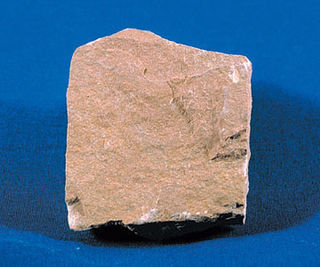
Sandstone is a clastic sedimentary rock composed mainly of sand-sized silicate grains. Sandstones comprise about 20–25% of all sedimentary rocks.

<span class="mw-page-title-main">Shale</span> Fine-grained, clastic sedimentary rock

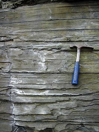
Shale is a fine-grained, clastic sedimentary rock formed from mud that is a mix of flakes of clay minerals (hydrous aluminium phyllosilicates, e.g. kaolin, Al2Si2O5(OH)4) and tiny fragments (silt-sized particles) of other minerals, especially quartz and calcite. Shale is characterized by its tendency to split into thin layers (laminae) less than one centimeter in thickness. This property is called fissility. Shale is the most common sedimentary rock.

<span class="mw-page-title-main">Sedimentary rock</span> Rock formed by the deposition and cementation of particles

Sedimentary rocks are types of rock that are formed by the accumulation or deposition of mineral or organic particles at Earth's surface, followed by cementation. Sedimentation is the collective name for processes that cause these particles to settle in place. The particles that form a sedimentary rock are called sediment, and may be composed of geological detritus (minerals) or biological detritus. The geological detritus originated from weathering and erosion of existing rocks, or from the solidification of molten lava blobs erupted by volcanoes. The geological detritus is transported to the place of deposition by water, wind, ice or mass movement, which are called agents of denudation. Biological detritus was formed by bodies and parts of dead aquatic organisms, as well as their fecal mass, suspended in water and slowly piling up on the floor of water bodies. Sedimentation may also occur as dissolved minerals precipitate from water solution.

<span class="mw-page-title-main">Boulder</span> Natural rock fragment larger than 10 inches

In geology, a boulder is a rock fragment with size greater than 25.6 centimetres (10.1 in) in diameter. Smaller pieces are called cobbles and pebbles. While a boulder may be small enough to move or roll manually, others are extremely massive. In common usage, a boulder is too large for a person to move. Smaller boulders are usually just called rocks or stones. The word boulder derives from boulder stone, from the Middle English bulderston or Swedish bullersten.

Sedimentology encompasses the study of modern sediments such as sand, silt, and clay, and the processes that result in their formation, transport, deposition and diagenesis. Sedimentologists apply their understanding of modern processes to interpret geologic history through observations of sedimentary rocks and sedimentary structures.

<span class="mw-page-title-main">Concretion</span> Compact mass formed by precipitation of mineral cement between particles

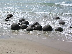
A concretion is a hard, compact mass formed by the precipitation of mineral cement within the spaces between particles, and is found in sedimentary rock or soil. Concretions are often ovoid or spherical in shape, although irregular shapes also occur. The word 'concretion' is derived from the Latin concretio "(act of) compacting, condensing, congealing, uniting", itself from con meaning 'together' and crescere meaning "to grow". Concretions form within layers of sedimentary strata that have already been deposited. They usually form early in the burial history of the sediment, before the rest of the sediment is hardened into rock. This concretionary cement often makes the concretion harder and more resistant to weathering than the host stratum.

<span class="mw-page-title-main">Geode</span> Hollow formation inside a rock

A geode is a geological secondary formation within sedimentary and volcanic rocks. Geodes are hollow, vaguely spherical rocks, in which masses of mineral matter are secluded. The crystals are formed by the filling of vesicles in volcanic and subvolcanic rocks by minerals deposited from hydrothermal fluids; or by the dissolution of syn-genetic concretions and partial filling by the same or other minerals precipitated from water, groundwater, or hydrothermal fluids.

<span class="mw-page-title-main">Siltstone</span> Sedimentary rock which has a grain size in the silt range

Siltstone, also known as aleurolite, is a clastic sedimentary rock that is composed mostly of silt. It is a form of mudrock with a low clay mineral content, which can be distinguished from shale by its lack of fissility.

<span class="mw-page-title-main">Rock City, Kansas</span>

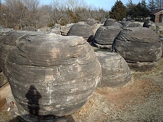
Rock City is a park located on hillsides overlooking the Solomon River in Ottawa County, Kansas. It is 3.6 miles south of Minneapolis, Kansas and just over 0.5 mile west of Kansas highway K-106 and the Minneapolis City County Airport on Ivy Road. In a patch of prairie about 500 meters long and 40 meters wide, Rock City contains three clusters of large spherical boulders. These three clusters contain a total of 200 spherical boulders. It has been designated as a National Natural Landmark.

<span class="mw-page-title-main">Boulder clay</span> Geological deposit of clay

Boulder clay is an unsorted agglomeration of clastic sediment that is unstratified and structureless and contains gravel of various sizes, shapes, and compositions distributed at random in a fine-grained matrix. The fine-grained matrix consists of stiff, hard, pulverized clay or rock flour. Boulder clay is also known as either known as drift clay; till; unstratified drift, geschiebelehm (German); argile á blocaux (French); and keileem (Dutch).

<span class="mw-page-title-main">Moeraki</span> Village in Otago, New Zealand

Moeraki is a small fishing village on the east coast of the South Island of New Zealand. It was once the location of a whaling station. In the 1870s, local interests believed it could become the main port for the north Otago area and a railway line, the Moeraki Branch, was built to the settlement and opened in 1877. However, the port could not compete with Oamaru and the lack of traffic as well as stability problems caused by difficult terrain led to the closure of the railway in 1879 after only two years' operation.

<span class="mw-page-title-main">Clastic rock</span> Sedimentary rocks made of mineral or rock fragments

Clastic rocks are composed of fragments, or clasts, of pre-existing minerals and rock. A clast is a fragment of geological detritus, chunks, and smaller grains of rock broken off other rocks by physical weathering. Geologists use the term clastic to refer to sedimentary rocks and particles in sediment transport, whether in suspension or as bed load, and in sediment deposits.

<span class="mw-page-title-main">Red Rock Coulee</span> Nature preserve in Canada

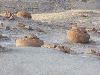
Red Rock Coulee is a Provincial Natural Area in southeastern Alberta, Canada, 54 kilometres (30 mi) south-southwest of the city of Medicine Hat and 26 kilometres (20 mi) south of the hamlet of Seven Persons on Alberta Highway 887. The main feature of this natural landscape is the large spherical reddish boulders (concretions), some of which measure 2.5 metres (8.2 ft) in diameter. They are scattered across the badlands and coulees, and can be seen along the hiking trails, as well as from the viewpoint on Highway 887.

This glossary of geology is a list of definitions of terms and concepts relevant to geology, its sub-disciplines, and related fields. For other terms related to the Earth sciences, see Glossary of geography terms.

<span class="mw-page-title-main">Achilles Point</span>

Achilles Point is a rocky point on the headland at the eastern end of the small sandy beach named Ladies Bay, Auckland, New Zealand. The name 'Te Pane o Horoiwi' can also sometimes refer to the whole headland between St Heliers and Tamaki River estuary. Achilles Point is named after a ship called HMNZS Achilles (70) which defeated the German pocket battleship Admiral Graf Spee in 1939. The headland, from the point round to the Tamaki heads, was previously known as Te Pane o Horoiwi, named after Horoiwi who arrived in New Zealand on the Tainui canoe (waka).

Igneous rocks are found in Bukit Timah, Woodlands, and Pulau Ubin island. Granite makes up the bulk of the igneous rock. Gabbro is also found in the area and is found in an area called Little Guilin, named for its resemblance to Guilin in South China. This area is in Bukit Gombak. Sedimentary rocks are found on the western part of Singapore, which is mainly made of sandstone and mudstones. It also includes the southwestern area. Metamorphic rocks are found in the northeastern part of Singapore, and also on Pulau Tekong, off the east coast of Singapore. The rocks are mainly made up of quartzite, and also make up the Sajahat Formation.

<span class="mw-page-title-main">Gad Cliff</span>

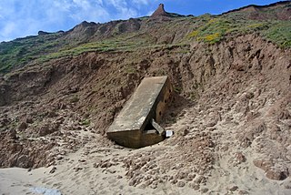
Gad Cliff is a south-facing cliff face, immediately to the east of Worbarrow Tout and Pondfield Cove, on the south coast of the Isle of Purbeck in Dorset, England. Behind it is Gold Down, part of the Lulworth Ranges.

<span class="mw-page-title-main">Shallow water marine environment</span>

Shallow water marine environment refers to the area between the shore and deeper water, such as a reef wall or a shelf break. This environment is characterized by oceanic, geological and biological conditions, as described below. The water in this environment is shallow and clear, allowing the formation of different sedimentary structures, carbonate rocks, coral reefs, and allowing certain organisms to survive and become fossils.

<span class="mw-page-title-main">Ward Beach</span> Beach in New Zealand

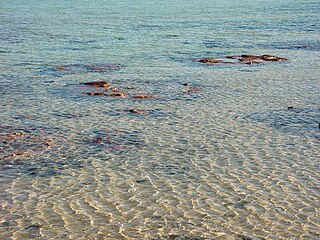
Ward Beach is a section of rugged coastline in the Marlborough Region of New Zealand that is known for unusual rock formations. The geological features include the exposed reef platforms that were uplifted by 2 m or more during the 2016 Kaikōura earthquake, and the spherical concretions known as the Ward Beach boulders. Another formation known as the Chancet Rocks is located in a scientific reserve about 1.5 km to the north of the Ward Beach roadend. They contain unusual trace fossils and provide amongst the best on-land evidence of the Cretaceous–Paleogene boundary in marine sediments in the Southern Hemisphere.

References

  1. 1 2 3 4 5 Boles, J. R., C. A. Landis, and P. Dale, 1985, The Moeraki Boulders; anatomy of some septarian concretions, Journal of Sedimentary Petrology, vol. 55, n. 3, p. 398-406.
  2. Fordyce, E., and P. Maxwell, 2003, Canterbury Basin Paleontology and Stratigraphy, Geological Society of New Zealand Annual Field Conference 2003 Field Trip 8, Miscellaneous Publication 116B, Geological Society of New Zealand, Dunedin, New Zealand. ISBN   0-908678-97-5
  3. 1 2 3 4 5 6 Forsyth, P.J., and G. Coates, 1992, The Moeraki boulders. Institute of Geological & Nuclear Sciences, Information Series no. 1, (Lower Hutt, New Zealand)
  4. 1 2 3 4 5 Thyne, G.D., and J.R. Boles, 1989, Isotopic evidence for origin of the Moeraki septarian concretions, New Zealand, Journal of Sedimentary Petrology. v. 59, n. 2, p. 272-279.
  5. 1 2 3 C. Dann and N. Peat, 1989, Dunedin, North and South Otago. GP Books. Wellington, New Zealand. ISBN   0-477-01438-0.
  6. Mutch, A. R., 1966, Moeraki Boulders in A. H. McLintock, ed., An Encyclopaedia of New Zealand. Government Printer, Wellington, New Zealand.
  7. 1 2 Pearson, M.J., and C.S. Nelson, 2005, Organic geochemistry and stable isotope composition of New Zealand carbonate concretions and calcite fracture fills Archived 2008-07-09 at the Wayback Machine , New Zealand Journal of Geology & Geophysics. v. 48, p. 395-414.
  8. Pearson, M.J.; Nelson, C.S. (2006). "Organic chemical signatures of New Zealand carbonate concretions and calcite fracture fills as potential fluid migration indicators". New Zealand Petroleum Conference Proceedings. Crown Minerals Group, Auckland, New Zealand.
  9. Scotchman, I.C., 1991, The geochemistry of concretions from the Kimmeridge Clay Formation of southern and eastern England, Sedimentology. v. 38, p. 79-106.
  10. Hudson, J.D., M.L. Coleman, B.A. Barreiro and N.T.J. Hollingworth, 2001, Septarian concretions from the Oxford Clay (Jurassic, England, UK): involvement of original marine and multiple external pore fluids, Sedimentology. v. 48, p. 507-531.

Further reading

45°20′42.99″S170°49′33.82″E / 45.3452750°S 170.8260611°E / -45.3452750; 170.8260611