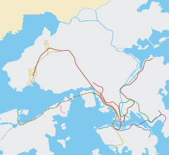
The Mass Transit Railway (MTR) is a major public transport network serving Hong Kong. Operated by the MTR Corporation (MTRCL), it consists of heavy rail, light rail, and feeder bus service centred on a 10-line rapid transit network serving the urbanised areas of Hong Kong Island, Kowloon, and the New Territories. The system included 245.3 km (152.4 mi) of rail as of December 2022 with 179 stations, including 99 heavy rail stations, 68 light rail stops and 1 high-speed rail terminus.

Yau Tsim Mong District is one of 18 districts of Hong Kong, located on the western part of Kowloon Peninsula. It is the core urban area of Kowloon. The district has the second highest population density of all districts, at 49,115 km2 (18,963 sq mi). The 2016 By-Census recorded the total population of Yau Tsim Mong District at 342,970.

The Tsuen Wan line is one of the ten lines of the metro network in Hong Kong's MTR. It is indicated in red on the MTR map.

The Kwun Tong line is a rapid transit line of the MTR network in Hong Kong, coloured green on the MTR map. Starting at Whampoa in Hung Hom and ending at Tiu Keng Leng in Tseung Kwan O, Sai Kung, the route has 17 stations and takes 35 minutes to complete. The Kwun Tong line is one of the busiest railway lines on the network connecting the central and the eastern portions of Kowloon via Wong Tai Sin. The line is mostly underground, but includes a lengthy elevated section, and runs generally in an east-west direction. During the morning rush hour, the Kwun Tong line utilises 33 trains running at 29tph to achieve a route capacity of 85,000 pphpd.

Prince Edward is an area of Mong Kok south of Tong Mi surrounding Prince Edward station in Kowloon, Hong Kong. Named after Prince Edward Road West, the Prince Edward station of the MTR rapid transit system is an interchange station on the Tsuen Wan and the Kwun Tong lines.

Mei Foo is a Hong Kong MTR station located in Mei Foo Sun Chuen, Lai Chi Kok, New Kowloon. It is the only interchange station between the Tsuen Wan line and the Tuen Ma line, situated between Lai Chi Kok and Lai King stations on the Tsuen Wan line and Nam Cheong and Tsuen Wan West stations on the Tuen Ma line. Mei Foo station's colour is blue.

Prince Edward is a station of the MTR rapid transit system in Hong Kong. It is located in Mong Kok, Kowloon, under the intersection of Nathan Road and Prince Edward Road West, after which it is named.

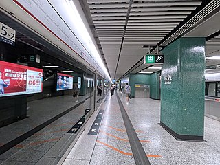
Yau Ma Tei, formerly named Waterloo after Waterloo Road, is an MTR station located in Yau Ma Tei, Kowloon. It is served by the Kwun Tong line and the Tsuen Wan line. The station opened on 22 December 1979 and was renamed as Yau Ma Tei on 31 May 1985 along with Argyle and Chater (Central).

Central is an MTR station located in the Central area of Hong Kong Island. The station's livery is firebrick red but brown on the Tsuen Wan line platforms. The station is the southern terminus of the Tsuen Wan line, a stop on the Island line, and connects to Hong Kong station, which serves the Tung Chung line and the Airport Express.

Admiralty is a station of the MTR rapid transit system in Admiralty, Hong Kong.

Nathan Road is the main thoroughfare in Kowloon, Hong Kong, aligned south–north from Tsim Sha Tsui to Sham Shui Po. It is lined with shops and restaurants and throngs with visitors, and was known in the post–World War II years as the Golden Mile, a name that is now rarely used. It starts on the southern part of Kowloon at its junction with Salisbury Road, a few metres north of Victoria Harbour, and ends at its intersection with Boundary Street in the north. Portions of the Kwun Tong and Tsuen Wan lines run underneath Nathan Road. The total length of Nathan Road is about 3.6 km (2.2 mi).

Kowloon Tong is a station on MTR's Kwun Tong line and East Rail line in New Kowloon, Hong Kong. The station serves Kowloon Tong and its vicinity, including Yau Yat Tsuen, the Festival Walk shopping centre, City University of Hong Kong and Hong Kong Baptist University.

Kwun Tong is a station on the MTR Kwun Tong line in Hong Kong. The station opened on 1 October 1979 as the eastern terminus of the first phase of the Kwun Tong line, until the Eastern Harbour Crossing to Quarry Bay opened on 6 August 1989. It is located in the Kwun Tong area, between Lam Tin and Ngau Tau Kok stations.

Ho Man Tin is an underground MTR rapid transit station on the Kwun Tong line and the Tuen Ma line, located beneath Valley Road in Lo Lung Hang, as part of the Sha Tin to Central Link project. The station's lower platforms opened on 23 October 2016 along with Whampoa station as part of the Kwun Tong line extension, while the upper platforms of the Tuen Ma line opened on 27 June 2021.
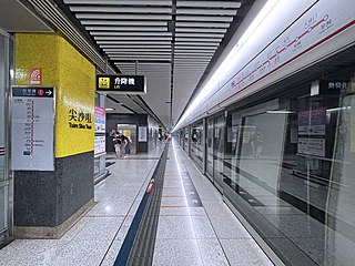
Tsim Sha Tsui is an MTR station on the Tsuen Wan line. The station, originally opened on 16 December 1979 on the Tsuen Wan line, serves the area of Tsim Sha Tsui.
Jordan is a station on the Hong Kong MTR Tsuen Wan line. It has dark green and light green livery. It is named after Jordan Road.
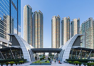
Kowloon is a station on the Tung Chung line and the Airport Express of Hong Kong's MTR. It is one of the two Airport Express stations providing in-town check-in services for passengers departing from Hong Kong International Airport and free shuttle bus services to most major hotels in the Tsim Sha Tsui and Yau Ma Tei areas.

Mong Kok East station – formerly Mong Kok railway station and Yaumati railway station – is a station on Hong Kong's East Rail line. Only out-of-system interchange is available with Kwun Tong line and Tsuen Wan line at Mong Kok station via a footbridge. The station is connected to Grand Century Place, a large shopping mall.

Argyle Street is a four-lane dual-way thoroughfare in Kowloon, Hong Kong, connecting the districts of Mong Kok, Ho Man Tin, Ma Tau Wai and Kowloon City. It runs on an east-west alignment starting at its intersection with Cherry Street, Ferry Street and Tong Mi Road in the west, and ending near the former Kai Tak Airport in the east. Due to the street's proximity with the latter, a variety of aircraft could be seen from this street and thus photographers seized the opportunity to capture landing aircraft.

The Hong Kong Strategic Route and Exit Number System is a system adopted by the Transport Department of the Hong Kong Government to organise the major roads in the territory into routes 1 to 10 for the convenience of drivers. When the system was implemented in 2004, the government promoted it with a major public campaign, including the slogan "Remember the Numbers; Make Driving Easier".


 Exit C3 access to Langham Place (2020)
 Station concourse (2020)
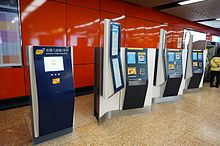 Ticket sales and Octopus card top-up machines in the unpaid area of the concourse (2017)
 Platform 1 in February 2014
 Exit D2 in March 2006