
Alberta is one of the thirteen provinces and territories of Canada. Located in Western Canada, the province has an area of 661,190 km2 (255,290 sq mi) and is bounded to the south by the United States state of Montana along 49° north for 298 km (185 mi); to the east at 110° west by the province of Saskatchewan for 1,223 km (760 mi); and at 60° north the Northwest Territories for 644 km (400 mi). The southern half of the province borders British Columbia along the Continental Divide of the Americas on the peaks of the Rocky Mountains, while the northern half borders British Columbia along the 120th meridian west. Along with Saskatchewan it is one of only two landlocked provinces or territories.

Kootenay National Park is a national park of Canada located in southeastern British Columbia. The park consists of 1,406 km2 (543 sq mi) of the Canadian Rockies, including parts of the Kootenay and Park mountain ranges, the Kootenay River and the entirety of the Vermilion River. While the Vermilion River is completely contained within the park, the Kootenay River has its headwaters just outside the park boundary, flowing through the park into the Rocky Mountain Trench and eventually joining the Columbia River. The park ranges in elevation from 918 m (3,012 ft) at the southwestern park entrance to 3,424 m (11,234 ft) at Deltaform Mountain.

The North Cascades are a section of the Cascade Range of western North America. They span the border between the Canadian province of British Columbia and the U.S. state of Washington and are officially named in the U.S. and Canada as the Cascade Mountains. The portion in Canada is known to Americans as the Canadian Cascades, a designation that also includes the mountains above the east bank of the Fraser Canyon as far north as the town of Lytton, at the confluence of the Thompson and Fraser Rivers.

The Okanagan, also known as the Okanagan Valley and sometimes as the Okanagan Country, is a region in the Canadian province of British Columbia defined by the basin of Okanagan Lake and the Canadian portion of the Okanagan River. It is part of the Okanagan Country, extending into the United States as Okanogan County in north-central Washington. According to the 2016 Canadian census, the region's population is 362,258. The largest populated cities are Kelowna, Penticton, Vernon and West Kelowna.
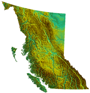
British Columbia is the westernmost province of Canada, bordered by the Pacific Ocean. With an area of 944,735 km2 (364,764 sq mi) it is Canada's third-largest province. The province is almost four times the size of the United Kingdom and larger than every United States state except Alaska. It is bounded on the northwest by the U.S. state of Alaska, directly north by Yukon and the Northwest Territories, on the east by Alberta, and on the south by the U.S. states of Washington, Idaho, and Montana. Formerly part of the British Empire, the southern border of British Columbia was established by the 1846 Oregon Treaty. The province is dominated by mountain ranges, among them the Canadian Rockies but dominantly the Coast Mountains, Cassiar Mountains, and the Columbia Mountains. Most of the population is concentrated on the Pacific coast, notably in the area of Vancouver, located on the southwestern tip of the mainland, which is known as the Lower Mainland. It is the most mountainous province of Canada.
The North American Cordillera, sometimes also called the Western Cordillera of North America, the Western Cordillera or the Pacific Cordillera, is the North American portion of the American Cordillera, the mountain chain system (cordillera) along the western coast of the Americas. The North American Cordillera covers an extensive area of mountain ranges, intermontane basins and plateaus in Western/Northwestern Canada, Western United States and Mexico, including much of the territory west of the Great Plains.
British Columbia mainland coastal forests is a temperate coniferous forest ecoregion the Pacific coast of North America, as defined by the World Wildlife Fund (WWF) categorization system.

The Creston Valley Wildlife Management Area is a Canadian river delta wetland and Wildlife Management Area near Creston in south-central British Columbia, on the floodplain of the Kootenay River at the south end of Kootenay Lake. Predominantly marshland, it was classified as a wetland of international importance on February 21, 1994, and is also a globally significant Important Bird Area. It is one of the "few significant agricultural areas of the province", and is in the Montane Cordillera. It stretches north along Kootenay Lake for approximately 20 km, and south to the United States border. It is both the only breeding site of the Forster's tern and the only site with leopard frogs in the province, as well as one of the few Canadian habitats for the Coeur D'Alene salamander. Creston Valley provides staging and nesting areas for migratory birds on the Pacific Flyway.
The Atlantic Maritime Ecozone, as defined by the Commission for Environmental Cooperation (CEC), is an ecozone which covers the Canadian provinces of Prince Edward Island, Nova Scotia, and New Brunswick, as well as the Gaspé Peninsula of Quebec. It is adjacent to the Atlantic Marine Ecozone to the east, and the Mixedwood Plains to the west. The roughly-corresponding Level I Ecoregion to this ecozone in the United States Environmental Protection Agency's classification, which is also part of the CEC system, is the Northern Forests ecoregion, though that classification includes the woodlands and swamps of northern Michigan and Minnesota, which are adjacent to the Boreal Shield ecozone.

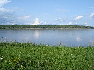
The Boreal Plains Ecozone, as defined by the Commission for Environmental Cooperation (CEC), is a terrestrial ecozone in the western Canadian provinces of Manitoba, Saskatchewan and Alberta. It also has minor extensions into northeastern British Columbia and south-central Northwest Territories. The region extends over 779,471 km2, of which 58,981 km2 is conserved.
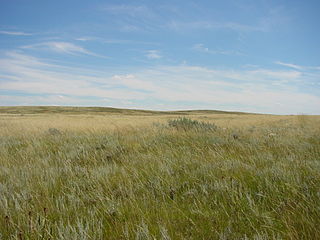
The Prairies Ecozone is a Canadian terrestrial ecozone which spans the southern areas of the Prairie provinces of Alberta, Saskatchewan, and Manitoba. It is a productive agricultural area, and is commonly referred to as "Canada's breadbasket". Farmland covers about 94% of the land, and is the dominant domestic economic activity of the zone, as well as an important factor in Canadian foreign trade. Natural gas and oil are abundant in the area. The corresponding Level II ecoregion of the US Environmental Protection Agency is the Great Plains Ecoregion.
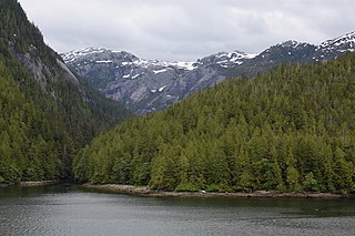
The Pacific Maritime Ecozone, as defined by the Commission for Environmental Cooperation (CEC), is a Canadian terrestrial ecozone, spanning a strip approximately 200 kilometres wide along the British Columbia Coast, then narrowing along the border with Alaska. It also includes all marine islands of British Columbia and a small portion of the southwestern corner of the Yukon. Fourteen ecoregions comprise the Ecozone, ranging from the Mount Logan Ecoregion in the north to the Cascade Ecoregion and Lower Mainland Ecoregion in the south.
The Taiga Plain Ecozone, as defined by the Commission for Environmental Cooperation (CEC), is a Canadian terrestrial ecozone that covers most of the western Northwest Territories, extending to northwest Alberta, northeast British Columbia and slightly overlapping northeastern Yukon.

The Taiga Cordillera Ecozone, as defined by the Commission for Environmental Cooperation (CEC), is a rugged, mountainous terrestrial ecozone of Canada spanning most of northern Yukon and significant portions of the border between the Yukon and the Northwest Territories.

The Boreal Cordillera Ecozone, as defined by the Commission for Environmental Cooperation (CEC), is a Canadian terrestrial ecozone occupying most of the northern third of British Columbia and southern half of Yukon. Within it is found Kluane National Park and Reserve, and a small portion of the southern range of Nahanni National Park Reserve. Most of the area's population is based in the city of Whitehorse, and it contains most of Yukon's population. The portion in British Columbia is barely populated.

The Cascade Mountains leeward forests are a temperate coniferous forest ecoregion of North America, as defined by the World Wildlife Fund (WWF) categorization system.

The Arkansas Valley is a Level III ecoregion designated by the Environmental Protection Agency (EPA) in the U.S. states of Arkansas and Oklahoma. It parallels the Arkansas River between the flat plains of western Oklahoma and the Arkansas Delta, dividing the Ozarks and the Ouachita Mountains with the broad valleys created by the river's floodplain, occasionally interrupted by low hills, scattered ridges, and mountains. In Arkansas, the region is often known as the Arkansas River Valley, especially when describing the history and culture of the region.

The forests of Canada are located across much of the country. Approximately half of Canada is covered by forest, totaling around 2.4 million km2. Over 90% of Canada's forests are owned by the public. About half of the forests are allocated for logging.

Okanagan dry forests is a temperate coniferous forest ecoregion in the Pacific Northwest of North America, as defined by the World Wildlife Fund (WWF) categorization system. It is closely associated with the Okanagan region of British Columbia and Washington. Only 20% of the ecosystem is still intact, and continues to be under threat for preservation due to land clearing and urban expansion, alongside the increasing threats of fire and extreme weather due to climate change.
