8 whale oil lamps (1797), Fresnel lens (later) 1903-1987, VRB-25 1987-2023, as of 11/06/2023 the same (reconditioned) 3 1/2 order bivalve Fresnel lens that was removed in 1987. (current)
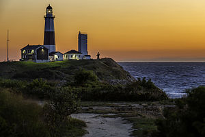
The lighthouse, which is located on Turtle Hill at the easternmost tip of Long Island, at 2000 Montauk Highway, is a privately run museum, and is not part of Montauk Point State Park.[4]
Montauk Light was the first lighthouse in New York State, and is the fourth-oldest active lighthouse in the United States. The tower is 110'6" high. The current light is a 3 1/2 order bivalve (clamshell) Fresnel lens.
On April 12, 1792, construction on the lighthouse was authorized by the 2nd United States Congress under President George Washington. Ezra L'Hommedieu, a lawyer, member of the Continental Congress in Philadelphia,[5] and a man with scientific interests, consulted with Washington on its construction. He represented the New York City Chamber of Commerce on discussions related to the lighthouse. He made the case that New York City "was first among American ports in the volume of its foreign commerce. By 1797, the harbor was handling a third of the nation's trade with other countries."[6] Due to prevailing winds in winter, shippers approaching from sea needed a lighthouse at the end of Long Island to guide them along the south side into New York harbor.[6]
L'Hommedieu chose the site for the lighthouse[7] and designed it.[6] The project began on June 7, 1796, and was completed on November 5, 1796, the first public works project of the new United States of America. Sometime in early April 1797, keeper Jacob Hand lit the wicks in the lamps in the tower, and the lighthouse began operation. It continued under civilian keepers until World War II, when the US Army took it over.[8]
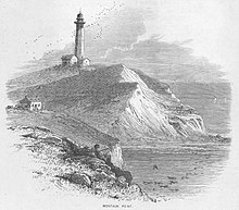
In 1860, the lighthouse station underwent a massive renovation when two new levels and a larger lantern were added. This increased the height of the tower from its original 80 feet (1796) to its current height of 110' 6". A first-order Fresnel lens—12 feet high, 6 feet in diameter, and weighing about 10,000 pounds—was installed in the new lantern; the current keeper's dwelling was constructed adjacent to the tower, and the original 1796 dwelling was demolished. A steam-powered fog signal was installed in 1873, with a fog signal building in 1897. The tower was originally all white; its single brown stripe was added in 1899. A fourth-order fixed red range-light was added to the watch deck of the tower in 1903 to warn of Shagwong Reef, a navigational hazard about 31⁄2 miles northwest of the lighthouse. This light was severely damaged in the hurricane of September 21, 1938 and removed on July 1, 1940 when the lighthouse was electrified. The huge first-order Fresnel lens was replaced in 1903 with a 31⁄2 order bivalve Fresnel lens, which served until February 3, 1987, when it was replaced with an airport beacon with a strength of 2.5million candela. However, as of November 6, 2023 the 3 1/2 order bivalve Fresnel lens that was replaced in 1987 has been restored and is now back atop the lighthouse.
During World War II, the lighthouse was taken over by the U.S. Army as part of the Eastern Coastal Defense Shield. The last three civilian keepers, Thomas Buckridge, Jack Miller, and George Warrington, departed in the spring of 1943. Adjacent to the lighthouse, Camp Hero, opened by the Army in 1942, had two 16 inch gun batteries of two guns each, and a battery of two six-inch guns. The casemates, gun emplacements and concrete fire control towers (which are also at nearby Shadmoor State Park) are still visible.
In 1946 the United States Coast Guard took over maintenance of the lighthouse and operated it until the station was automated on February 3, 1987. In May of that year, the lighthouse museum opened to the public, operated by the Montauk Historical Society. It leased the property from the US Coast Guard for that purpose. On September 30, 1996 President Bill Clinton signed legislation transferring the lighthouse property to the Montauk Historical Society.
The tower was built on Turtle Hill 300 feet (90m) from the edge of the cliff; due to the cumulative effects of shoreline erosion, it is now 100 feet (30m) away from the edge. After World War II, the United States Army Corps of Engineers built a seawall at its base, but the erosion continued. The Coast Guard considered tearing down the lighthouse in 1967 and replacing it with a steel tower farther from the edge of the bluff. In the wake of protests over the announced dismantling of the tower, Congressman Michael Forbes proposed a bill to the United States Congress to hand over the Lighthouse to the Montauk Historical Society from the public so it could be preserved;[9] the bill was passed.
Giorgina Reid (1908–2001), a textile designer, had saved her Rocky Point, New York cottage from collapse by building a simple set of terraces in the gullies of the bluff. She proposed that solution to the Society at Montauk. Reid's concept, Reed-Trench Terracing, called for building the terrace platforms made of various beach debris, notably reeds; the practice (along with further strengthening of the rocks at the bluff toe) appeared to stem the erosion. She patented the process and published an article about it titled "How to Hold up a Bank".[10] Greg Donohue, a Montauk landscaper, worked with Reid at the Point and kept the project moving forward after she retired in 1986. With support from various sources, including the Montauk Historical Society and the State of New York, the Erosion Control Project of Montauk Point was successfully completed in 1998.[11][12][dubious–discuss]
However, the recurrence of the erosion threat in ensuing years has prompted further action: In November 2006, the United States Army Corps of Engineers' plan to build another seawall was opposed by a local surfing group, who contended that a seawall would ruin the nearby world-renowned surf break. They proposed moving the lighthouse back from the shore, as was done with the Cape Hatteras Lighthouse.[13] Complicating such a move is the terrain, which would require the lighthouse to be moved down one hill and up another. Environmental groups have raised concerns that reducing the erosion at Montauk would increase erosion at other Long Island beaches, as there are always related effects to such infrastructure work.[14]
The United States Army Corps of Engineers announced on January 13, 2020 the award of a $30.7 million contract to H&L Contracting of Bayshore, New York to restore and protect the lighthouse from shoreline erosion. Work began in 2021 and ended in August 2023.[15] The approximately 1,000 linear feet stone revetment work consisted of removing and reusing existing five- and 10-ton armor stones, placement of new 10- and 15-ton armor stones, and providing slope stabilization with terracing and vegetation above the upper crest of the revetment. The project also included a complete repainting of the lighthouse. The total project cost $44 million.[15]
Pirate Captain Kidd was said to have buried treasure at the foot of the lighthouse site around 1699 at two ponds which today are called "Money Ponds."[16]
Cape Hatteras Light is a lighthouse located on Hatteras Island in the Outer Banks in the town of Buxton, North Carolina and is part of the Cape Hatteras National Seashore. The lighthouse's semi-unique pattern makes it easy to recognize and famous. It is often ranked high on lists of most beautiful, and famous lighthouses in the US.
Execution Rocks Light is a lighthouse in the middle of Long Island Sound on the border between New Rochelle and Sands Point, New York. It stands 55 feet (17 m) tall, with a white light flashing every 10 seconds. The granite tower is painted white with a brown band around the middle. It has an attached stone keeper's house which has not been inhabited since the light was automated in 1979.
The Point Wilson Light is an active aid to navigation located in Fort Worden State Park near Port Townsend, Jefferson County, Washington. It is one of the most important navigational aids in the state, overlooking the entrance to Admiralty Inlet, the waterway connecting the Strait of Juan de Fuca and Puget Sound. The lighthouse was listed on the Washington State Heritage Register and the National Register of Historic Places in 1971.
Sand Key Light is a lighthouse 6 nautical miles southwest of Key West, Florida, between Sand Key Channel and Rock Key Channel, two of the channels into Key West, on a reef intermittently covered by sand. At times the key has been substantial enough to have trees, and in 1900 nine to twelve thousand terns nested on the island. At other times the island has been washed away completely.
The Sankaty Head Light is a lighthouse located on Nantucket island. It was built in 1850, was automated in 1965, and is still in operation. It is located at the easternmost point of the island, in the village of Siasconset. It was one of the first lighthouses in the United States to receive a Fresnel lens.
Goat Island Light is a lighthouse located off Cape Porpoise near Kennebunkport in southern Maine. Goat Island Light was established in 1835 to guard the entrance to Cape Porpoise Harbor. The original station was upgraded in 1859 to the current brick tower with a fifth order Fresnel lens. Keeper's quarters were added to the island in 1860. The light station was automated by the United States Coast Guard in 1990 and is currently active. The keepers dwellings and tower are leased to the Kennebunkport Conservation Trust. Goat Island Light can be seen from shore in Cape Porpoise Harbor just off State Route 9 north of Kennebunkport or is viewable by boat. The island is currently closed to the public except by special arrangement.
The Cape Arago Lighthouse is a lighthouse located in Charleston, Oregon. It is located 2.6 miles (4.2 km) north of Cape Arago.
Fort Point Light is a decommissioned lighthouse built on the third tier of Fort Point, which is now directly beneath the south anchorage of the Golden Gate Bridge in San Francisco, California. The lighthouse is at the south end of the narrowest part of Golden Gate strait. It was preceded by two other lighthouses in nearby locations. The present lighthouse was in operation from 1864 until 1934.
Point Arena Light is a lighthouse in Mendocino County, California, United States, two miles (3 km) north of Point Arena, California. It is approximately 130 mi (210 km) south of San Francisco, in the Fort Point Group of lighthouses. The lighthouse features a small museum and gift shop. Guided tours of the light station as well as self-guided tours of the grounds are available daily.
The Lynde Point Light or Lynde Point Lighthouse, also known as Saybrook Inner Lighthouse, is a lighthouse in Connecticut, United States, on the west side of the mouth of the Connecticut River on the Long Island Sound, Old Saybrook, Connecticut. The first light was a 35 feet (11 m) wooden tower constructed by Abisha Woodward for $2,200 and it was completed in 1803. A new lighthouse was eventually needed and a total of $7,500 was appropriated on July 7, 1838. Jonathan Scranton, Volney Pierce, and John Wilcox were contracted to build the new 65-foot (20 m) octagonal brownstone tower. It was constructed in 1838 and lit in 1839. The lighthouse was renovated in 1867 and had its keeper's house from 1833 replaced in 1858 with a Gothic Revival gambrel-roofed wood-frame house. In 1966, the house was torn down and replaced by a duplex house. The original ten lamps were replaced in 1852 with a fourth-order Fresnel lens, and with a fifth-order Fresnel lens in 1890. Lynde Point Lighthouse used whale oil until 1879 when it switched to kerosene. It was electrified in 1955 and fully automated by the United States Coast Guard in 1978. In 1990, it was added to the National Register of Historic Places and is significant for its "superior stone work in the tapering brownstone walls".
The Cove Point Light is a lighthouse located on the west side of Chesapeake Bay in Calvert County, Maryland.
Cape Charles Lighthouse is an octagonal cast iron skeleton tower lighthouse at the mouth of the Chesapeake Bay on Smith Island which was officially removed from service in 2019. It is the tallest lighthouse in Virginia and the second tallest in the United States. This particular tower is the third lighthouse at this location. The first lighthouse at Cape Charles was a 55-foot (17 m) masonry tower completed in 1828. It was quickly deemed inadequate for its important seacoast location due to its low height and poor visibility at sea. It was soon threatened by erosion so in 1864 it was replaced by a 150-foot (46 m) masonry tower built further inland. Located a little more than a mile southwest of the old tower and 600 feet from the shoreline, the impressive 150-foot-tall conical brick tower was similar in appearance to the 1857 Cape May Lighthouse, painted white and topped with a dark brown lantern room. In 1892, a twenty-five-foot red band was painted around the white tower's midsection, about sixty feet up from the base, to make it more visible during the day. By the 1890s, it too was threatened by beach erosion which jetties built to protect it failed to halt, and with the lighthouse now only 300 feet from the ocean and the shoreline eroding at a rate of 37 feet per year it was decided that a third lighthouse needed to be built three quarters of a mile inland.
The Fort Point Light, or Fort Point Light Station, is located in Fort Point State Park, in Stockton Springs, Maine. A lighthouse at this point has served as an active aid to navigation since 1835; the present lighthouse dates to 1857, and is listed on the National Register of Historic Places.
Gay Head Light is a historic lighthouse located on Martha's Vineyard westernmost point off of Lighthouse Road in Aquinnah, Massachusetts.
Plum Island Light is located on the western end of Plum Island, which lies in the Long Island Sound, east of Orient Point at the end of the North Fork of Long Island, New York. An historic granite lighthouse originally built in 1869 sits at the site, but no longer serves as an active aid to navigation. It was listed on the National Register of Historic Places in 2011.
The Sand Point Lighthouse is located in Escanaba, Michigan, United States, on Lake Michigan's northern shore. Since 1989, it has been an unofficial aid to navigation. Though it is an operational aid to navigation. The restored lighthouse is now open to the public during the summer months. It is also known as the Escanaba/Sand Point Light or the Escanaba Light.
Petit Manan Light is a lighthouse on Petit Manan Island, Maine. The island is at the end of a series of ledges extending out from Petit Manan Point, between Dyer Bay and Pigeon Hill Bay, that projects into the Gulf of Maine.
The Chandeleur Island Light was a lighthouse established in 1848 near the northern end of the Chandeleur Islands in the Gulf of Mexico, off the east coast of Louisiana. Hurricane Katrina destroyed the light in 2005.
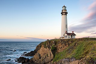
Pigeon Point Light Station or Pigeon Point Lighthouse is a lighthouse built in 1871 to guide ships on the Pacific coast of California. It is the tallest lighthouse on the West Coast of the United States. It is still an active Coast Guard aid to navigation. Pigeon Point Light Station is located on the coastal highway, 5 miles (8 km) south of Pescadero, California, between Santa Cruz and San Francisco. The 115-foot (35 m), white masonry tower, resembles the typical New England structure.
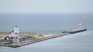
The Grand Marais Harbor of Refuge Inner and Outer Lights are a pair of lighthouses located on the west pier at the entry to Grand Marais Harbor of Refuge, in Grand Marais, Michigan. They were listed on the National Register of Historic Places in 2012.
This page is based on this Wikipedia article Text is available under the CC BY-SA 4.0 license; additional terms may apply. Images, videos and audio are available under their respective licenses.