Monte Mario

Last updated

Monte Mario
Hill of Rome
Latin nameMons Vaticanus, Clivus Cinnae
Italian nameMonte Mario
Rione Prati
BuildingsVilla Mellini, Villa del Pigneto,
John Felice Rome Center
Churches Madonna del Rosario, Nostra Signora di Guadalupe a Monte Mario

Monte Mario (English: Mount Mario or Mount Marius) [1] [2] [3] [4] [5] is the hill that rises in the north-west area of Rome (Italy), on the right bank of the Tiber, crossed by the Via Trionfale. It occupies part of Balduina, of the territory of Municipio Roma I (Roma Centro), of Municipio Roma XIV (Roma Monte Mario) and a small portion of Municipio Roma XV of Rome, thus including part of the Quarters Trionfale, Della Vittoria and Primavalle.

Contents

The same toponym also identifies the urban area which extends over the hill, close to Via Trionfale and the first stretch of Via di Torrevecchia, with the railway station of the same name.

It is the highest (139 m) hill in the town and, together with the Janiculum and the Pincius, one of the most scenic spots in the city, especially in the place called "Zodiac", which offers a south and west view of the main architectural monuments of the city, of the Vatican City, of the Alban Hills, of the Monti Tiburtini, of the Monti Prenestini and of the highest peaks of western central Apennines. Here, moreover, begins the longest Linear Park in Rome, which connects the town to the Parco di Monte Ciocci.

The location has been chosen as trigonometrical station in the Gauss–Boaga cartographic projection, giving rise to the datum Roma 40.

Although it is the highest hill in the modern city of Rome, Monte Mario is not one of the proverbial Seven Hills of Rome, being outside the boundaries of the ancient city.

History

Prati di Castello and Monte Mario in a watercolor by Ettore Roesler Franz PratiDiCastelloEMonteMarioByRoeslerFranz.jpg
Prati di Castello and Monte Mario in a watercolor by Ettore Roesler Franz

Excavations carried out in the Cartoni estate, close to Monte Mario, have found a flint tool, some splinters of the same material and animal teeth. The remains date back to about 65,000 years ago and are the oldest finds in the area of Rome.

In the Middle Ages Monte Mario was located on the Via Francigena; pilgrims referred to it as Mons Gaudii (Latin for Mount of the Joy). [6] The Via Francigena came from the Leonine City and continued towards La Giustiniana and then La Storta; then, having passed Isola Farnese, it continued north.

Origin of the name

The hill was known as Mons Vaticanus or Clivus Cinnae (from the name of the Consul Lucius Cornelius Cinna) during the ancient Roman period.

The current name, according to some theories, comes from Mario Mellini, [7] a cardinal who owned a villa (since 1935 the seat of the Museo Astronomico e Copernicano of Rome [8] ) and several hamlets around the hill in the 15th century. A second hypothesis derives the name from the word mare (Italian for "sea"), referring to the fossil shells found there or to the fact that from some heights is it possible to see the sea. Finally, a third hypothesis is related to the medieval name of the hill, Monte Malo ("Bad Mountain"), due to the murder of the patrician Giovanni Crescenzio that took place there in 998.

Description

Radio-television antenna tower at the RAI broadcast and transmission centre in Monte Mario RAI TV antenna mast in Rome Monte Mario 1.jpg
Radio-television antenna tower at the RAI broadcast and transmission centre in Monte Mario

The eastern part of the hill is a nature reserve [9] and on the west side lies the now upmarket district of the same name. Atop one hill is the church and convent of the Madonna del Rosario. On the hilltop, in the site of the 15th-century Villa Mellini, rises the Monte Mario Observatory, part of the Rome Observatory, and the Museo Astronomico Copernicano. This location (12°27'8.4"E ) was used as the prime meridian (rather than Greenwich) for the maps of Italy until the 1960s. The side of the hill was the former site of the Villa del Pigneto, built by Pietro da Cortona. The ruins of the structure were razed in the 19th century.

The John Felice Rome Center, one of the four campuses of Loyola University Chicago, is located on the hill in Via Massimi.

The other settlements on the hill include:

The built-up area of the hill include middle and high-bourgeois residential districts, such as Balduina, Trionfale, Belsito and Della Vittoria, as well as a more popular area, corresponding to the northernmost part of Primavalle.

The part of Della Vittoria Suburb overlooking Piazza Nostra Signora di Guadalupe is called Monte Mario Alto ("High Monte Mario") and develops close to Colle Sant'Agata, where, in the 1920s, a cooperative of post and telegraph workers built the first settlement. Other popular housing units were added in the 1930s, while the full edification was completed between the 1960s and the 1980s.

Monte Mario is also historically linked to the complex of the former Manicomio Santa Maria della Pietà, one of the largest and oldest mental health hospital in Europe.

Parks and green areas

The park of Monte Mario MonteMarioRome.jpg
The park of Monte Mario

Historical re-enactment of Monte Mario Circuit

In 2004, thanks to Moto Guzzi Roma and under the patronage of the Lazio Region, of the Province of Rome and of Roma Capitale, the Monte Mario Circuit was reborn: it is a circuit crossed by Tazio Nuvolari with his Bianchi 350 (the legendary Blue Arrow) on February 24, 1925.

See also

Notes

  1. Donadoni, Eugenio (July 11, 1969). "A History of Italian Literature: With Additional Materials on Twentieth-century Literature". New York University Press via Google Books.
  2. Wharton, Annabel Jane (2001). Building the Cold War: Hilton International Hotels and Modern Architecture. Chicago: University of Chicago Press. p. 147.
  3. "The Wax Works". Tampa Bay Times. March 16, 1948. p. 32. Retrieved February 20, 2020 via Newspapers.com. Open Access logo PLoS transparent.svg
  4. "Colony on Mount Mario Is Broken Up". The Pittsburgh Press. May 17, 1908. p. 9. Retrieved February 20, 2020 via Newspapers.com. Open Access logo PLoS transparent.svg
  5. MacNamara, Robert F. (1956). The American College in Rome, 1855–1955. Rochester, NY: Christopher Press. p. 501.
  6. According to Ferdinand Gregorovius, Geschichte der Stadt Rom im Mittelalter, vol. IV, Munich, C. H. Beck, 1988, p. 660.
  7. Vasi, Mariano (July 11, 1819). "A new Picture of Rome, and its Environs, in the form of an Itinerary: With numerous views & a large plan of ancient and modern Rome". Leigh via Google Books.
  8. [ dead link ] in the official website of the Museo Astronomico e Copernicano
  9. "R.N. Monte Mario". October 29, 2012. Retrieved December 28, 2016.

Related Research Articles

Province of Rieti Province of Italy

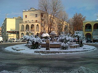
The Province of Rieti is a province in the Lazio region of Italy. Its capital is the city of Rieti. Established in 1927, it has an area of 2,750.52 square kilometres (1,061.98 sq mi) with a total population of 157,887 people as of 2017. There are 73 comuni in the province.

Administrative subdivisions of Rome Administrative, urbanistic and historic or toponomastic subdivisions

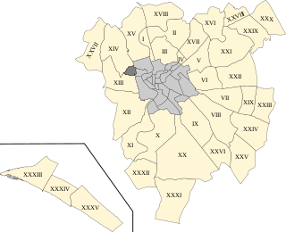
The city of Rome, Italy is divided into first-level administrative subdivisions.

Monte Soratte Mountain in Italy

Monte Soratte is a mountain ridge in the Metropolitan City of Rome, central Italy. It is a narrow, isolated limestone ridge with a length of 5.5 km (3.4 mi) and six peaks. Located some 10 km (6.2 mi) south east of Civita Castellana and c. 45 km (28 mi) north of Rome, it is the sole notable ridge in the Tiber Valley. The nearest settlement is the village of Sant'Oreste. Saint Orestes or Edistus, after whom the settlement is named, is said to have been martyred near Monte Soratte.

Prati Rione of Rome in Latium, Italy

Prati is the 22nd rione of Rome, identified by the initials R. XXII. It belongs to the Municipio I since 2013, while previously, along with Borgo and quartieri Trionfale and Della Vittoria, it was part of the Municipio XVII.

Rome Observatory Observatory

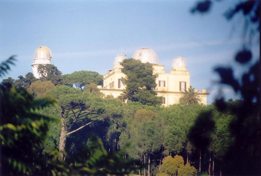
The Astronomical Observatory of Rome is one of twelve Astronomical Observatories in Italy. The main site of the Observatory is Monte Porzio Catone. Part of the Istituto Nazionale di Astrofisica since 2002.

Primavalle Quartiere of Rome in Latium, Italy

Primavalle is the 27th quartiere of Rome, identified by the initials Q. XXVII. It is part of the Municipio XIV.

Municipio XIX Place in Rome, Italy

The Municipio XIX was an administrative subdivision of the city of Rome. Following the administrative reform of 11 March 2013, it was suppressed and merged into the new, and coextensive, Municipio XIV. Its territory is situated to the north-west part of the municipality of Rome.

Balduina is an urban area that belongs to the Municipio XIX of the comune of Rome, and to the fourteenth borough of the city,. Situated at 139 metres above sea level on the southern side of Monte Mario, Balduina is the highest part of Rome. The population is 42,000.

Municipio I Municipio of Rome in Lazio, Italy

Municipio I is an administrative subdivision of the municipality of Rome, encompassing the centre of the city.

FL3 (Lazio regional railways)

The FL3 is a commuter rail route. It forms part of the network of the Lazio regional railways, which is operated by Trenitalia, and converges on the city of Rome, Italy.

Outline of Rome Overview of and topical guide to Rome

The following outline is provided as an overview of and topical guide to Rome:

Quarters of Rome

The Quarters of Rome are the areas in and around the Italian city of Rome which became urbanised after the foundation of the last city-centre rione, Prati.

Riserva Naturale di Monte Salviano Italian nature reserve

The Riserva Naturale di Monte Salviano or Riserva naturale guidata Monte Salviano is a nature reserve in Abruzzo, Italy, established in 1999. It lies in the territory of the comune (municipality) of Avezzano, in the Province of L'Aquila. The reserve is named after Monte Salviano, a massif that extends northwest to southwest dividing the Fucine basin from the Palentine Plains, in the Marsica sub-region.

Madonna del Rosario (Rome) Church in Rome, Italy

Madonna del Rosario is a church of Rome (Italy) in the Quarter Della Vittoria, rising in Via Trionfale, Monte Mario.

Forte Monte Mario is one of the 15 forts of Rome, built between 1877 and 1891.
It is located in Rome (Italy), in the Quarter Q. XV Della Vittoria, within the Municipio I.

Forte Braschi is one of the 15 forts of Rome, built in the period between 1877 and 1891 to constitute the "entrenched field of Rome".
It is located in the Quarter Q. XIV Trionfale, within the Municipio XIV.

Suburbs of Rome

The Suburbi di Roma are the third level of toponomastic subdivision of the Municipality of Rome (Italy).

Aurelio (Rome) Quartiere of Rome in Lazio, Italy

Aurelio is the 13th quartiere of Rome (Italy), identified by the initials Q. XIII. It belongs to the Municipio XIII and Municipio XIV.

Trionfale Quartiere of Rome in Lazio, Italy

Trionfale[trioɱˈfaːle] is the 14th quartiere of Rome (Italy), identified by the initials Q. XIV. The toponym also indicates the urban zone 19E of Municipio XIV.

References

Coordinates: 41°55′30″N12°27′6″E / 41.92500°N 12.45167°E / 41.92500; 12.45167