
Glacier National Park is an American national park located in northwestern Montana, on the Canada–United States border, adjacent to the Canadian provinces of Alberta and British Columbia. The park encompasses over 1 million acres (4,000 km2) and includes parts of two mountain ranges, over 130 named lakes, more than 1,000 different species of plants, and hundreds of species of animals. This vast pristine ecosystem is the centerpiece of what has been referred to as the "Crown of the Continent Ecosystem," a region of protected land encompassing 16,000 square miles (41,000 km2).

Grinnell Lake is located in Glacier National Park, in the U. S. state of Montana. Named after George Bird Grinnell, the lake has an opaque turquoise appearance from the rock flour (silt) which is transported to the lake from Grinnell Glacier. Grinnell Lake is accessible via the Grinnell Glacier Trail and is 3.2 miles (5.1 km) from the Many Glacier Hotel.

Mount Stimson is the second highest peak in Glacier National Park, located in Montana, United States. It is part of the Lewis Range, which spans much of the park. It is located in the remote southwestern portion of the park, approximately 5 miles (8.0 km) west of the Continental Divide and 12 miles (19 km) southeast of Lake McDonald. It is drained by Pinchot Creek and Nyack Creek, both of which flow into the Middle Fork of the Flathead River. The mountain is named for Henry L. Stimson (1867–1950), former U.S. Secretary of State and twice Secretary of War, who hiked and assisted George Bird Grinnell survey the area in and around Glacier National Park in the 1890s, and supported efforts to establish the national park.

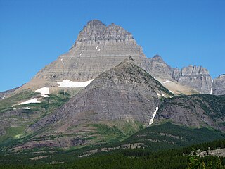
Mount Cleveland is the highest mountain in Glacier National Park, located in Montana, United States. It is also the highest point in the Lewis Range, which spans part of the northern portion of the Park and extends into Canada. It is located approximately 3 mi (4.8 km) southeast of the southern end of Waterton Lake, and approximately 5 mi (8.0 km) south of the US/Canada border. The east side of the future national park was purchased by the federal government from the Blackfoot Confederacy in 1895 during the second term of President Cleveland. According to the United States Board on Geographic Names, the mountain is named for the former president.
Mount Wilbur is located in the Lewis Range, Glacier National Park in the U.S. state of Montana. Plainly visible from the region of Many Glacier, the peak rises over 4,500 feet (1,372 m) above Swiftcurrent Lake and is a steep pyramid on three sides. The west slopes of the peak join to ridges along the continental divide. Much of the climbing routes are rated at class 4 to 5, with some only used once. The sedimentary rock of the mountains makes for often poor anchoring points and enhances the difficulty. A cirque on the north slopes of the mountain shelter Iceberg Lake, a popular hiking destination from Many Glacier.
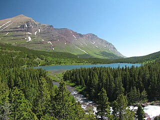
Swiftcurrent Lake is located in the Many Glacier region of Glacier National Park, in the U.S. state of Montana. The Many Glacier Hotel, the largest hotel in the park, is along the east shore of the lake. Many hiking trails originate from the area and scenic tour boats provide access to the lake for visitors.
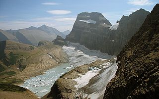
Grinnell Glacier is in the heart of Glacier National Park in the U.S. state of Montana. The glacier is named for George Bird Grinnell, an early American conservationist and explorer, who was also a strong advocate of ensuring the creation of Glacier National Park. The glacier is in the Lewis Range and rests on the north flank of Mount Gould at an altitude averaging 7,000 feet (2,100 m), in the Many Glacier region of the park.

Mount Gould is a peak on the Continental Divide in Glacier National Park, Montana, United States. It is the highest point of the Garden Wall, a distinctive ridge of the Lewis Range. It is most notable for its huge, steep east face, which drops 4,000 ft (1,220 m) in only one-half mile (0.8 km). This face provides a backdrop to Grinnell Lake, and is often photographed.

Babb is a small unincorporated farming and ranching community in Glacier County, Montana, United States, on the Blackfeet Indian Reservation. The community experiences a large influx of tourists in the summer months as it is the gateway to the Many Glacier area of Glacier National Park. Babb is a census-designated place (CDP) and had a population of 174 at the 2010 census.

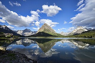
Mount Merritt is located in the Lewis Range, Glacier National Park in the U.S. state of Montana. The peak is one of six in Glacier National Park that rise over 10,000 feet (3,048 m). Located in the northeastern part of the park, Mount Merritt rises dramatically a vertical mile above nearby rivers. The approach to this remote peak involves a one way hike of 13 miles (21 km) to the summit base. Near the summit, the Old Sun Glacier hangs along the east ridge. The summit is named for General Wesley Merritt in 1891 by members of Troop C, 1st Cavalry who were visiting the region while stationed at Fort Assiniboine.

The following articles relate to the history, geography, geology, flora, fauna, structures and recreation in Glacier National Park (U.S.), the U.S. portion of the Waterton-Glacier International Peace Park.

Iceberg Peak is located in the Lewis Range, Glacier National Park in the U.S. state of Montana. Iceberg Peak rises more than 3,000 feet (910 m) above Iceberg Lake and is considered a difficult climb due to the steepness and exposure climbers must endure. The peak sits astride the continental divide 1.1 mi (1.8 km) WNW of Mount Wilbur.

Mount Custer is located in the Livingston Range, Glacier National Park in the U.S. state of Montana. Situated along the Continental Divide, Mount Custer rises more than 3,300 feet (1,000 m) above Lake Nooney, located below the summit to the east. Herbst Glacier is immediately northeast of the peak.

North Swiftcurrent Glacier is Glacier National Park in the U.S. state of Montana. The glacier is situated immediately to the east of the Continental Divide and north of Swiftcurrent Mountain at an elevation between 8,000 ft (2,400 m) and 7,000 ft (2,100 m) above sea level. North Swiftcurrent Glacier consists of several remnant glaciers and additional ice patches, none of which exceed 19 acres (0.077 km2) in surface area and do not meet the threshold of 25 acres (0.10 km2) often cited as being the minimum size to qualify as an active glacier. The glacier lost over 32 percent of its area between 1966 and 2005.
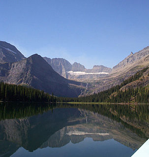
Lake Josephine is located in Glacier National Park, in the U. S. state of Montana. Swiftcurrent Lake is immediately to the northeast of Lake Josephine and the two lakes are separated by a short stream. Lake Josephine is accessible via the Grinnell Glacier Trail which follows the west shoreline of the lake for 1 mile (1.6 km).
Windmaker Lake is located in Glacier National Park, in the U. S. state of Montana. Swiftcurrent Mountain is west and Mount Wilbur is north of the lake. Unnamed creeks and the melt from the North Swiftcurrent Glacier feed the lake. Windmaker Lake can be reached by way of the Swiftcurrent Pass Trail.
Redrock Lake is located in Glacier National Park, in the U. S. state of Montana. Mount Wilbur is west of Redrock Lake. Prior to entering Redrock Lake, Swiftcurrent Creek tumbles over Redrock Falls which can be reached after an easy 1.8 miles (2.9 km) hike by way of the Swiftcurrent Pass Trail.
Iceberg Lake is located in Glacier National Park, in the U. S. state of Montana. Mount Wilbur is south and Iceberg Peak is west of Iceberg Lake. Iceberg Peak towers more than 3,000 feet (910 m) above the lake. A popular day hike destination, Iceberg Lake is a 4.8 miles (7.7 km) hike from the Swiftcurrent Auto Camp Historic District.

Grinnell Point is located in the Lewis Range, Glacier National Park in the U.S. state of Montana. Grinnell Point is an oft-photographed mountain, situated conspicuously just west of Swiftcurrent Lake across from the Many Glacier Hotel. Grinnell Point is a subpeak of Mount Grinnell, which lies .21 mi (0.34 km) to the west-southwest and is oftentimes misidentified as Mount Grinnell since that summit cannot be seen from the roads in the Many Glacier region. Grinnell Point is named for George Bird Grinnell.

Altyn Peak is located in the Lewis Range, Glacier National Park in the U.S. state of Montana. Altyn Peak is situated just north of Swiftcurrent Lake and the Many Glacier Hotel and is easily seen from both locations. The peak is named after Dave Greenwood Altyn who was a financial backer of a local mine in the late 1800s; the mining town of Altyn was at the junction of Canyon Creek and Swiftcurrent Lake. The peak was known as Crow Feet Mountain after the last chief of the Blackfeet confederacy of tribes.


 Redrock Lake with Mount Grinnell above Redrock Falls with Grinnell Point to the left.
 Mount Grinnell above Grinnell Lake
 Bullhead Lake, looking towards Mount Grinnell

