
Zambia is a landlocked country located in Southern Africa, to the east of Angola. It has a total area of 752,618 square kilometres, of which 9 220 km2 is water.
Solwezi is a town in Zambia. It is the provincial capital of the mineral-rich North-Western Province. Solwezi is also the administrative capital of Solwezi District, one of the eleven districts in the North-Western Province.

Chipata is a city and administrative centre of the Eastern Province of Zambia and Chipata District. It was declared the 5th city of the country, after Lusaka, Ndola, Kitwe and Livingstone, by President Edgar Lungu on 24 February 2017. The city has undergone rapid economic and infrastructure growth in the years, leading up to city status.

Kapiri Mposhi is a Zambian town and the seat of the Kapiri Mposhi District in Central Province. Located north of Lusaka, it stands on the Great North Road and is significant for the railway connection between the Zambia Railways line from Kitwe to Lusaka and the western terminus of the Tanzania-Zambia Railway Authority from Dar es Salaam since 1976.

Kabwe is the capital of the Zambian Central Province and the Kabwe District, with a population estimated at 202,914 at the 2010 census. Named Broken Hill until 1966, it was founded when lead and zinc deposits were discovered in 1902. Kabwe also has a claim to being the birthplace of Zambian politics as it was an important political centre during the colonial period.
Kasama is a city in the Northern Province of Zambia. It serves as the provincial capital and the headquarters of Kasama District.
Kalabo is an urban centre and the seat of Kalabo District, in the Western Province of Zambia.

Mpika is a town in the Muchinga Province of Zambia, lying at the junction of the M1 Road to Kasama and Mbala and the Tanzam Highway to Dar es Salaam, Tanzania in the north-east and Lusaka in the south-west. It also has a railway station on the TAZARA Railway about 5 kilometres (3 mi) away. Mpika is situated between the Muchinga Escarpment to the east and vast miombo plains to the west. The town has an estimated population of 40,000 inhabitants (2008), while the district population is estimated at 150,000 inhabitants. Since Mpika District was the biggest district in Zambia before its division in 2017, the population density was less than 4 people per square kilometre.
Kaoma is a town in Zambia. It is the headquarters of Kaoma District in the Western Province and is located on the M9 Road.

Central Province is one of Zambia's ten provinces. The provincial capital is Kabwe, which is the home of the Mulungushi Rock of Authority. Central Province has an area of 94,394 km (58,654 mi). It borders eight other provinces and has eleven districts. The total area of forest in the province is 9,095,566 ha, and it has a national park and three game management areas. The first mine in the region was opened up in 1905 making the then Broken Hill town the first mining town. In 1966, the town's name was reverted to its indigenous name - Kabwe meaning 'ore' or 'smelting'.

Southern Province is one of Zambia's ten provinces, and home to Zambia's premier tourist attraction, Mosi-oa-Tunya, shared with Zimbabwe. The centre of the province, the Southern Plateau, has the largest area of commercial farmland of any Zambian province, and produces most of the maize crop.
This article gives lists of the National Monuments and other historic sites of Zambia, with a one- or two-line description providing links to details given on other pages.

Lukanga Swamp is a major wetland in the Central Province of Zambia, about 50 km west of Kabwe. Its permanently swampy area consists of a roughly circular area with a diameter of 40 to 50 km covering 1850 km2, plus roughly 250 km2 in the mouths of and along rivers discharging into it such as the Lukanga River from the north-east, plus another 500 km2 either side of the Kafue River to the west and north-west, making 2600 km2 in total. It contains many lagoons such as Lake Chiposhye and Lake Suye but few large channels, and its average depth is only 1.5 m.
The biomes and ecoregions in the ecology of Zambia are described, listed and mapped here, following the World Wildlife Fund's classification scheme for terrestrial ecoregions, and the WWF freshwater ecoregion classification for rivers, lakes and wetlands. Zambia is in the Zambezian region of the Afrotropical biogeographic realm. Three terrestrial biomes are well represented in the country . The distribution of the biomes and ecoregions is governed mainly by the physical environment, especially climate.
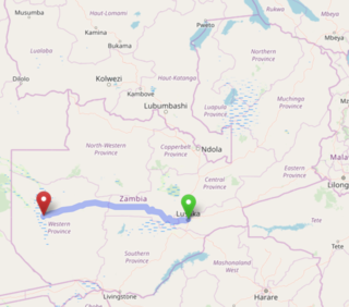
The Lusaka–Mongu Road of Zambia runs 580 km from the capital, Lusaka, to Mongu, capital of the Western Province. It connects that province to the rest of the country, as well as being one of two routes to the south-west extremity of North-Western Province. It also serves as the main highway of the western half of Central Province. The entire route from Lusaka to Mongu is designated as the M9 road.

Chilanga is a township located 20 km south of Zambia's capital city, Lusaka. It is situated midway between Lusaka and Kafue on the T2 road.

Mumbwa District is a district of Zambia, located in Central Province. The capital lies at Mumbwa. As of the 2010 Zambian Census, the district had a population of 218,328 people. It consists of two constituencies, being Mumbwa and Nangoma.

The T2 is a trunk road in Zambia. The road runs from the Tunduma border with Tanzania via Mpika, Kabwe and Lusaka to the Chirundu border with Zimbabwe. The road is the longest route of the country, as it is approximately 1,155 kilometres (718 mi). The route from Mpika to Kafue is a toll road. The route from Tanzania to Lusaka is Zambia's Great North Road and is part of the Tanzam Highway.
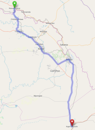
The T3 is a Trunk Road in Zambia. The road runs from Kapiri Mposhi via Ndola, Kitwe and Chingola to Kasumbalesa on the border with DR Congo. The entire route is a toll road.

