Municipal disinvestment

Last updated

Municipal disinvestment is a term in the United States which describes an urban planning process in which a city or town or other municipal entity decides to abandon or neglect an area. It can happen when a municipality is in a period of economic prosperity and sees that its poorest and most blighted communities are both the cheapest targets for revitalization as well as the areas with the greatest potential for improvement. [1] It is when a city is facing urban decay and chooses to allocate fewer resources to the poorest communities or communities with less political power, [2] and disenfranchised neighborhoods are slated for demolition, relocation, and eventual replacement. Disinvestment in urban and suburban communities tends to fall strongly along racial and class lines and may perpetuate the cycle of poverty exerted upon the space, since more affluent individuals with social mobility can more easily leave disenfranchised areas. [3]

Contents

History

New Deal and postwar era

Out of the New Deal came the Public Works Administration, funding the construction of thousands of low-rent homes and infrastructure development. Meanwhile the Homeowners Refinancing Act, as well as the Wagner-Steagall Housing Act three years later, provided generous incentives and reimbursements aimed at Americans recovering from the Great Depression who could not yet afford to invest in equity. In the postwar era, returning veterans were seeking homes to start families. [4] There was a period of intense residential expansion surrounding major US cities, and banks were gratuitously providing loans in order for families to afford moving there. It is in this new economic landscape where redlining, exclusionary zoning, and predatory lending flourished.

The programs that were then enacted provided more displacement than replacement,a nd the beginning years of housing and infrastructure development were defined by their clearance and destruction of communities. [1] The Housing Act of 1949 increased the mandate for public housing, but in claiming to combat "slums" and "blight," it was worded so vaguely that those terms could have been applied to almost all post-Depression urban neighborhoods. What was intended to rebuild in decayed communities was used against poor but otherwise-flourishing neighborhoods by labeling them ghettos. [1]

The Federal Aid Highway Act of 1956 extended demolition of neighborhoods with new roads cutting through the most vulnerable ones to create more direct arteries between the metropolitan and the downtown areas. Highway construction expanded upon the already--widening schism of urban poor and the suburban by further enabling white flight and reducing the focus on public transport.

Civil Rights Movement and Great Society

During the postwar era, municipalities sought to grow enriched and modernized communities from the slums that they demolished. As the Civil Rights Movement was in full display through highway revolts and responses to racial violence, there was a growing mindset among urban planners that a communal-focused, people-first approach should be taken, along the same lines as community development handled by the recently-enacted Peace Corps. [5]

President Lyndon B. Johnson continued the policies of his predecessor, John F. Kennedy, by signing into law during his first year in office the Civil Rights Act of 1964, the Voting Rights Act of 1965, and soon a series of bills that comprised the foundation of what was termed the "War on Poverty" and "Great Society" despite the protests from Congress, which was largely against racial integration. [1] The new philosophy of the administration focused intently on Community Action Agencies, fulfilled the demand from modernist social theorists and poured funding and resources into volunteer forces. [5] The direction of policy was seen as some as a form of direct investment in impoverished and minority neighborhoods, in contrast to the previous focus on new construction.

Daniel Patrick Moynihan served as Assistant Secretary of Labor under the Johnson administration and was a primary influence on policy development. Stemming from his controversial Moynihan Report, many of the programs that were enacted within the War on Poverty were intended to educate black and poor families to modernize their "culture." Government assistance, in the hundreds of millions of dollars, was intended for organic community growth, the nurturing of local governance, and a gradual transition from developing to developed urban regions. However, when municipalities shrank programs that they directly ran, the money was diverted to smaller unorthodox community action associations with unions or "social protest agendas." For example, in a community center funded by the Office of Economic Opportunity, the Black Panther Party started its development. [5]

Change in urban development policy

Johnson responded to the radicalization of Watts riots by ceding control of local Offices of Economic Opportunity to municipal authorities such as the mayor, a reversal of the original strategy of community-lead development; funding was reduced; and the practices of the offices and local community projects were more closely supervised. [5] Moynihan was startled by what he perceived as the consequences of the War on Poverty and changed his philosophy and its practice under Johnson. Moynihan found the social policies of the past decades naive in trying to fix the "tangled pathology," which he described in the white paper that he authored for the US Department of Labor, The Negro Family: The Case for National Action, nicknamed the Moynihan Report. [1] [5] [6] Under the Richard Nixon administration, Moynihan remained as Counselor to the President, where he further pushed for dismantling the Offices of Economic Opportunity. [5] It is during that time that Moynihan suggested to Nixon that black communities be treated with a "benign neglect," a philosophy of action that would later be translated into the planned shrinkage policies of the 1970s and 1980s.

In 1981, during the Ronald Reagan administration, the OEO changed into the Office of Community Services and became put under the control of Donald Rumsfeld and Dick Cheney, who more tightly controlled its function. [5]

Redlining

Exclusionary zoning

Benign neglect

Benign neglect is a policy proposed in 1969 by Daniel Patrick Moynihan, who was then on President Richard Nixon's staff as an urban affairs adviser. While serving in this capacity, he sent Nixon a memo that suggested, "The time may have come when the issue of race could benefit from a period of 'benign neglect.' The subject has been too much talked about. The forum has been too much taken over to hysterics, paranoids, and boodlers on all sides. We need a period in which Negro progress continues and racial rhetoric fades." [7] The policy was designed to ease tensions after the Civil Rights Movement of the late 1960s. Moynihan was particularly troubled by the speeches of Vice-President Spiro Agnew. However, the policy was widely seen as the municipal disinvestment to abandon urban neighborhoods, particularly ones with a majority-black population, as Moynihan's statements and writings appeared to encourage, for instance, fire departments engaging in triage to avoid a supposedly-futile war against arson. [2]

Planned shrinkage

The large number of fires in the South Bronx after the city slashed fire service there serves as a symbol of planned shrinkage to critics. BrokenPromises JohnFekner.jpg
The large number of fires in the South Bronx after the city slashed fire service there serves as a symbol of planned shrinkage to critics.

Planned shrinkage is a controversial public policy of the deliberate withdrawal of city services to blighted neighborhoods as a means of coping with dwindling tax revenues. [8] Planned shrinkage involves decreasing city services such as police patrols, garbage removal, street repairs, and fire protection from selected city neighborhoods. It has been advocated as a way to concentrate city services for maximum effectiveness given serious budgetary constraints, but it has been criticized as an attempt to "encourage the exodus of undesirable populations" [8] and to open up blighted neighborhoods for development by private interests.

Planned shrinkage occurred in the South Bronx of New York City and in the city of New Orleans. [9] [10] The term was first used in New York City in 1976 by Housing Commissioner Roger Starr. [11] [12]

For example, in the South Bronx, many firehouses were closed from the 1960s to the 1980s. Although firehouses were shut down all over the city during this period, the average number of people per engine by was over 44,000 in the South Bronx compared to just 17,000 in Staten Island. Firehouses in the Bronx were closed even as the fire alarm rate rose during the 1960s and the 1970s. Many of those planning decisions can be tracked to models created by the Rand corporation. [2] :7

Background

During the 20th century, a boom in suburban growth caused in part by increased automobile use led to urban decline, particularly in the poorer sections of many large cities in the United States and elsewhere. A dwindling tax base depleted many municipal resources. A common view was that it was part of a "downward spiral" caused first by an absence of jobs, the creation of a permanent underclass, and a declining tax base hurting many city services, including schools. It was that interplay of factors that made change difficult. [13] New York City was described as "so broke" by the 1970s, with neighborhoods that had become "so desperate and depleted" that municipal authorities wondered how to cope. [14] Some authorities felt the process of decline was inevitable and, instead of trying to fight it, searched for alternatives. According to one view, authorities searched for ways to have the greatest population loss in the areas with the poorest non-white populations. [2] [12]

RAND study

In the early 1970s, a RAND study examining the relation between city services and large city populations concluded that when services such as police and fire protection were withdrawn, the numbers of people in the neglected areas would decrease. [2] There had been questions about many fires that had been happening in the South Bronx during the 1970s. One account, including the RAND report, suggested that neighborhood fires were predominantly caused by arson though a contrasting report suggested that arson was not a major cause. [15] If arson was a primary cause, according to the RAND viewpoint, it did not make sense financially for the city to try to invest further funds to improve fire protection The RAND report allegedly influenced then US Senator Daniel Patrick Moynihan, who used the report's findings to make recommendations for urban policy. In Moynihan's view, arson was one of many social pathologies caused by large cities, and he suggested that a policy of "benign neglect" would be appropriate as a response. [2]

Case studies

New York City

Much of the Myrtle Avenue elevated line in Brooklyn, New York City, was demolished. Pictured is the remaining portion in 1974. BROOKLYN'S BUSHWICK AVENUE SEEN FROM AN ELEVATED TRAIN PLATFORM IN NEW YORK CITY. THE INNER CITY TODAY IS AN ABSOLUTE... - NARA - 555925.tif
Much of the Myrtle Avenue elevated line in Brooklyn, New York City, was demolished. Pictured is the remaining portion in 1974.

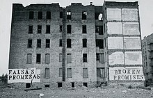
Partly in response to the RAND report, and in an effort to address New York's declining population, New York's housing commissioner, Roger Starr, proposed a policy which he termed planned shrinkage to reduce the impoverished population and better preserve the tax base. According to the "politically toxic" proposal, the city would stop investing in troubled neighborhoods and divert funds to communities "that could still be saved." [16] He suggested that the city should "accelerate the drainage" in what he called the worst parts of the South Bronx through a policy of planned shrinkage by closing subway stations, firehouses, and schools. Starr felt that those actions were the best way to save money. [17] Starr's arguments soon became predominant in urban planning thinking nationwide. [12] The people who lived in the communities where his policies were applied protested vigorously; without adequate fire service and police protection, the residents faced waves of crime and fires that left much of the South Bronx and Harlem devastated. [2] A report in 2011 in the New York Times suggested that the planned shrinkage approach was "short-lived." [18]

Under the planned shrinkage program, for example, an abandoned 100-unit development on one piece of land could be cleared by a real estate developer. Such an outcome would be preferable to ten separate neighborhood-based efforts to produce 100 housing units each, according to advocates of planned shrinkage. According to their view, a planned shrinkage approach would encourage so-called "monolithic development," resulting in new urban growth but at much lower population densities than the neighborhoods which had existed previously. [12] The remark by Starr caused a political firestorm, and Mayor Abraham Beame disavowed the idea while City Council members called it "inhuman," "racist," and "genocidal." [11]

According to one report, the high inflation during the 1970s combined with the restrictive rent control policies in the city meant that buildings were worth more dead for the insurance money than alive as sources of rental income. As investments, they had limited ability to provide a solid stream of rental income. Accordingly, there was an economic incentive on the part of building owners, according to this view, to simply let the buildings burn. An alternative view was that the fires were a result of the city's municipal policies. While there are differing views about whether planned shrinkage caused fire outbreaks in the 1970s or was a result of such fires, there is agreement that the fires in the South Bronx during those years were extensive. [2]

In the South Bronx, the average number of people per [fire] engine is over 44,000. In Staten Island, it's 17,000. There is no standard for manning areas of multiple dwellings as opposed to one- and two-family residences.

A New York City battalion chief from the New York City Fire Department interviewed in the BBC-TV special "The Bronx is Burning," in 1976. [2]
H.U.D. Secretary Patricia Harris, Jimmy Carter and New York Mayor Abraham Beame tour the South Bronx in 1977. Secretary of H.U.D. Patricia Harris, Jimmy Carter and New York Mayor Abraham Beame tour the South Bronx. - NARA - 176392.tif
H.U.D. Secretary Patricia Harris, Jimmy Carter and New York Mayor Abraham Beame tour the South Bronx in 1977.

By the mid-1970s, the Bronx had 120,000 fires per year, or an average of 30 fires every 2 hours. 40 percent of the housing in the area was destroyed. The response time for fires also increased, as the firefighters did not have the resources to keep responding promptly to numerous service calls. A report in The New York Post suggested that the cause of the fires was not arson but resulted from decisions by bureaucrats to abandon sections of the city. According to one report, of the 289 census tracts within the borough of the Bronx, seven census tracts lost more than 97% of their buildings, with 44 tracts losing more than 50% of their buildings, to fire and abandonment. [15]

There have been claims that planned shrinkage impacted public health negatively. [19] [20] According to one source, public shrinkage programs targeted to undermine populations of African-Americans and Hispanic-Americans in the South Bronx and Harlem had an effect on the geographic pattern of the AIDS outbreak. According to this view, municipal abandonment was interrelated with health issues and helped to cause a phenomenon termed "urban desertification". [21]

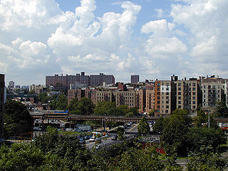
The populations in the South Bronx, Lower East Side, and Harlem plummeted during the two decades after 1970. Only then would the city again begin to invest in these areas.[ citation needed ]

New Orleans

New Orleans differed from other cities in that the cause of decline was based not on economic or political shifts but by rather a destructive flood caused by a hurricane. In the aftermath of Hurricane Katrina, planned shrinkage was proposed as a means to create a "more compact, more efficient and less flood-prone city". [10] Areas of the city that were most damaged by the flooding and thus were the most likely to be flooded again would not be rebuilt but become green space. [10] Those areas were frequently less desirable, lower-income areas which had lower property values precisely because of the risk of flooding. [10] Some residents rejected a "top-down" approach of planned shrinkage of municipal planners and attempted to rebuild in flood-prone areas. [9]
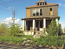
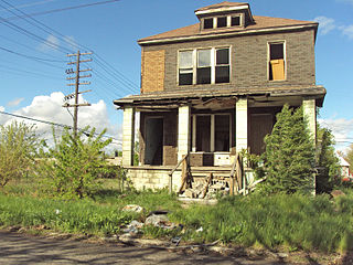
Detroit

The city of Detroit has gone through a major economic and demographic decline in recent decades. The population of the city has fallen from a high of 1,850,000 in 1950 to 677,116 in 2015, kicking it off the top 20 of US cities by population for the first time since 1850. [22] However, the city has a combined statistical area of 5,318,744 people, which currently ranks 12th in the United States. Local crime rates are among the highest in the United States (however, the overall crime rate in the city has seen a decline during the 21st century [23] ), and vast areas of the city are in a state of severe urban decay. In 2013, Detroit filed the largest municipal bankruptcy case in US history, which it successfully exited on December 10, 2014. Poverty, crime, shootings, drugs and urban blight in Detroit continue to be ongoing problems.

As of 2017 median household income is rising, [24] criminal activity is decreasing by 5% annually as of 2017, [25] and the city's blight removal project is making progress in ridding the city of all abandoned homes that cannot be rehabilitated.

Roxbury, Boston

Planned shrinkage in Roxbury, Boston is not unique to the RAND policies enacted in the 1970s and 1980s. The neighborhood succumbed to numerous fires by out-of-town landlords seeking out the only way to earn back some profit on homes that no longer sold. However, the neighborhood's response to planned shrinkage through community action has made it an example to other neighborhoods of the success of people-first organizing. The neighborhood had worked with the Boston's administration but refused to give in to bureaucratic control by the city and protested whenever the city neglected its redevelopment. [26]

"Shrink to survive"

"Shrink to survive" is a contemporary form of planned shrinkage which emphasizes short-term razing of the city. If a city enacting planned shrinkage policies takes a laissez-faire approach to disinvesting in its communities, cities can take an active role in that reduction. That includes investing in more aggressive land buyback and enforcement of eminent domain in order to obtain ownership of a property, relocate its residents, and demolish it. [27]

Shrink to survive is used in cities with a large number of abandoned buildings such as this home in Detroit. AbandonedHouseDelray.jpg
Shrink to survive is used in cities with a large number of abandoned buildings such as this home in Detroit.

Such proposals, which began around 2009, entail razing entire districts within some cities or else bulldozing them to return the land to its pre-construction rural state. [28] The policies have been studied not only by municipal and state authorities but also by the federal government, and may affect dozens of declining cities in the United States. [29] One report suggested that 50 US cities were potential candidates; they include Detroit, Philadelphia, Pittsburgh, Baltimore and Memphis. [28] Proponents claim the plan will bring efficiency with less waste and fraud; [28] detractors complain the policy has been a "disaster" and advocate for community-based efforts instead. [30]

Flint

Shrink to survive was initiated by Dan Kildee during his term as Treasurer of Genesee County, Michigan. [31] He proposed it as a way to handle municipal problems in Flint, which had experienced an exodus of people and business during the automobile industry downturn. [32] Flint had been described as one of the poorest Rust Belt cities. [28] One estimate was that its population had declined by half since 1950. [32] [33] In 2002, authorities established a "municipal land bank" to buy abandoned or foreclosed homes to prevent them from being bought up by real estate speculators. [31] One report was that by the summer of 2009, 1,100 homes in Flint had been bulldozed and that another 3,000 had been scheduled for demolition. One estimate was that the city's size would shrink by twenty per cent, [31] [34] while a second estimate was that it needed to contract by 40% to once again become viable financially.

In other cities

Shrink to survive has been enacted in other medium-sized cities in the American Rust belt such as the Michigan city Benton Harbor, [13] as well as the Ohio city of Youngstown. [35] One report suggested that city authorities in Youngstown had demolished 2,000 derelict homes and businesses. [35] In addition, shrink-to-survive has been considered for inner city suburbs of Detroit. [32]

Municipal authorities in Gary, Indiana, are considering plans to shrink the city by 40%, possibly by demolition or by letting nature overgrow abandoned buildings, as a way to raise values for existing structures, reduce crime, and restore the city to fiscal health. [36] The city has suffered a sustained decline in job losses, followed by a housing bust. [36]

Abandoned properties tear at a city's social fabric. Vacant homes, empty lots and illegal dumps make remaining residents feel isolated, kill community spirit, and breed crime. Providing city services to largely-abandoned neighborhoods wreaks havoc on Gary's budget.

Nick Bogert, NBC News, June 2013 [36]

See also

Related Research Articles

<span class="mw-page-title-main">The Bronx</span> Borough in New York City

The Bronx is a borough of New York City, coextensive with Bronx County, in the U.S. state of New York. It is south of Westchester County; north and east of the New York City borough of Manhattan, across the Harlem River; and north of the New York City borough of Queens, across the East River. The Bronx is the only New York City borough not primarily located on an island. The Bronx has a land area of 42 square miles (109 km2) and a population of 1,472,654 in the 2020 census. If each borough were ranked as a city, the Bronx would rank as the ninth-most-populous in the U.S. Of the five boroughs, it has the fourth-largest area, fourth-highest population, and third-highest population density. The population density of the Bronx was 32,718.7 inhabitants per square mile (12,632.8/km2) in 2022, the third-highest population density of any county in the United States, behind Manhattan and Brooklyn. With a population that is 54.8% Hispanic as of 2020, it is the only majority-Hispanic county in the Northeastern United States and the fourth-most-populous nationwide.

<span class="mw-page-title-main">Hunts Point, Bronx</span> Neighborhood of the Bronx in New York City

Hunts Point is a neighborhood located on a peninsula in the South Bronx of New York City. It is the location of one of the largest food distribution facilities in the world, the Hunts Point Cooperative Market. Its boundaries are the Bruckner Expressway to the west and north, the Bronx River to the east, and the East River to the south. Hunts Point Avenue is the primary street through Hunts Point.

<span class="mw-page-title-main">Longwood, Bronx</span> Neighborhood of the Bronx in New York City

Longwood is a mixed-use neighborhood in the southwest Bronx in New York City. Its boundaries, starting from the north and moving clockwise are East 167th Street to the north, the Bronx River and the Bruckner Expressway to east, East 149th Street to the south, and Saint Anns Avenue to the west. Southern Boulevard is the primary thoroughfare through Longwood.

<span class="mw-page-title-main">Melrose, Bronx</span> Neighborhood of the Bronx in New York City

Melrose is a mostly residential neighborhood in the southwestern section of the New York City borough of the Bronx. It adjoins the business and one-time theater area known as The Hub. Melrose is rectangular-shaped, being bordered by Saint Anns Avenue on the east, 149th Street on the south, Park Avenue on the west, and 163rd Street to the north. Melrose Avenue and Third Avenue are the primary thoroughfares through Melrose.

<span class="mw-page-title-main">History of Detroit</span>

Detroit, the largest city in the state of Michigan, was settled in 1701 by French colonists. It is the first European settlement above tidewater in North America. Founded as a New France fur trading post, it began to expand during the 19th century with U.S. settlement around the Great Lakes. By 1920, based on the booming auto industry and immigration, it became a world-class industrial powerhouse and the fourth-largest city in the United States. It held that standing through the mid-20th century.

Urban decay is the sociological process by which a previously functioning city, or part of a city, falls into disrepair and decrepitude. There is no single process that leads to urban decay.

<span class="mw-page-title-main">Infill</span> Rededication of land in an urban environment to new construction

In urban planning, infill, or in-fill, is the rededication of land in an urban environment, usually open-space, to new construction. Infill also applies, within an urban polity, to construction on any undeveloped land that is not on the urban margin. The slightly broader term "land recycling" is sometimes used instead. Infill has been promoted as an economical use of existing infrastructure and a remedy for urban sprawl. Detractors view increased urban density as overloading urban services, including increased traffic congestion and pollution, and decreasing urban green-space. Many also dislike it for social and historical reasons, partly due to its unproven effects and its similarity with gentrification.

<span class="mw-page-title-main">Crotona Park East, Bronx</span> Neighborhood of the Bronx in New York City

Crotona Park East, also known as Crotona or East Morrisania, is a residential neighborhood geographically located in the southwest Bronx in New York City. Crotona Park East is considered part of the South Bronx. Its boundaries, starting from the north and moving clockwise are the Cross-Bronx Expressway to the north, the Bronx River to the east, East 167th Street to the south, and Crotona/Prospect Avenues to the west. Southern Boulevard is the primary thoroughfare through the area. The neighborhood is adjacent to, but distinct from, the nearby park named Crotona Park.

<span class="mw-page-title-main">Morris Heights, Bronx</span> Neighborhood of the Bronx in New York City

Morris Heights is a residential neighborhood located in the West Bronx. Its boundaries, starting from the north and moving clockwise are: West Burnside Avenue to the north, Jerome Avenue to the east, the Cross-Bronx Expressway to the south, and the Harlem River to the west. University Avenue is the primary thoroughfare through Morris Heights.

<span class="mw-page-title-main">West Farms, Bronx</span> Neighborhood of the Bronx in New York City

West Farms is a residential neighborhood in The Bronx, New York City. Its boundaries, are: Bronx Park to the north, the Bronx River Parkway to the east, the Cross-Bronx Expressway to the south, and Southern Boulevard to the west. East Tremont Avenue is the primary thoroughfare through West Farms.

The Heidelberg Project is an outdoor art project in the McDougall-Hunt neighborhood on Detroit's east side, just north of the city's historically African-American Black Bottom area. It was created in 1986 by the artist Tyree Guyton, who was assisted by his wife, Karen, and grandfather Sam Mackey. The Heidelberg Project is in part a political protest, as Tyree Guyton's childhood neighborhood began to deteriorate after the 1967 riots. Guyton described coming back to Heidelberg Street after serving in the Army; he was astonished to see that the surrounding neighborhood looked as if "a bomb went off".

<span class="mw-page-title-main">Shrinking city</span> Dense cities that have experienced notable population loss

Shrinking cities or urban depopulation are dense cities that have experienced a notable population loss. Emigration is a common reason for city shrinkage. Since the infrastructure of such cities was built to support a larger population, its maintenance can become a serious concern. A related phenomenon is counterurbanization.

As of 2018, Detroit had the fourth highest murder rate among major cities in the United States after St. Louis and Baltimore and the 42nd highest murder rate in the world. The rate of robberies in Detroit declined by 67% between 1985 and 2014 while the rate of aggravated assaults increased. As a whole, the city's crime rate has decreased considerably from its 1980s peak.

<span class="mw-page-title-main">East Bronx</span> Region of the Bronx in New York City

The East Bronx is the part of the New York City borough of the Bronx which lies east of the Bronx River; this roughly corresponds to the eastern half of the borough. Neighborhoods include: Baychester, Castle Hill, City Island, Co-op City, Country Club, Eastchester, Edenwald, Edgewater Park, Harding Park, Morris Park, Parkchester, Pelham Bay, Pelham Parkway, Soundview, Throggs Neck, Van Nest, Wakefield, Westchester Square, and Williamsbridge.

African-American neighborhoods or black neighborhoods are types of ethnic enclaves found in many cities in the United States. Generally, an African American neighborhood is one where the majority of the people who live there are African American. Some of the earliest African-American neighborhoods were in New Orleans, Mobile, Atlanta, and other cities throughout the American South, as well as in New York City. In 1830, there were 14,000 "Free negroes" living in New York City.

In the United States, housing segregation is the practice of denying African Americans and other minority groups equal access to housing through the process of misinformation, denial of realty and financing services, and racial steering. Housing policy in the United States has influenced housing segregation trends throughout history. Key legislation include the National Housing Act of 1934, the G.I. Bill, and the Fair Housing Act. Factors such as socioeconomic status, spatial assimilation, and immigration contribute to perpetuating housing segregation. The effects of housing segregation include relocation, unequal living standards, and poverty. However, there have been initiatives to combat housing segregation, such as the Section 8 housing program.

The Detroit Demolition Program was started in 2014 by a major push from Detroit Mayor Mike Duggan. The program relied on federal and state funding to remove commercial and housing properties that were not in use and had unlivable conditions. The plan was for 40,000 properties to be taken down to allow for property values to rise and have land for new homes and office space to be built in the city. Poverty and crime continue to impact the city, and the demolition program was created in hopes to improve conditions for the people living in the urban areas of Detroit. As of April 2019, the program is in effect with plans to continue for eight more years.

<span class="mw-page-title-main">South Bronx</span> Region of the Bronx in New York City

The South Bronx is an area of the New York City borough of the Bronx. The area comprises neighborhoods in the southern part of the Bronx, such as Concourse, Mott Haven, Melrose, and Port Morris.

Twin Parks is a housing development in the Bronx, New York City. Its buildings were designed by leading architects, and were widely hailed as "the cutting edge of public design" when constructed in the early 1970s.

Roger Starr was an intelligence officer during World War II, a businessman active in community organizations, and New York City housing administrator until his removal. He later became a writer for the New York Times. One of his books was titled The Living End (1966).

References

  1. 1 2 3 4 5 Platt, Rutherford H. (2014). Reclaiming American Cities: the Struggle for People, Place, and Nature since 1900. USA: University of Massachusetts Press. pp. 79–171. ISBN   978-1-62534-050-4.
  2. 1 2 3 4 5 6 7 8 9 A Plague on Your Houses: How New York Was Burned Down and National Public Health Crumbled By Deborah Wallace, Rodrick Wallace. 2001. (Note: fire chief interviewed in the BBC-TV special "The Bronx is Burning," in 1976.) ISBN   1-85984-253-4
  3. Body-Gendrot, Sophie (2000). the Social Control of Cities. Malden, Massachusetts: Blackwell Publishers Ltd. p. 34. ISBN   0-631-20520-9.
  4. "The House We Live In." Race: The Power of an Illusion, episode 3, written by Larry Adelman, edited by Llewellyn M. Smith, PBS, 2003.
  5. 1 2 3 4 5 6 7 Immerwahr, Daniel (January 1, 2015). Thinking Small: The United States and the Lure of Community Development. Harvard University Press. pp. 150–170. ISBN   9780674289949. JSTOR   j.ctt13x0h4w.
  6. Moynihan, Daniel Patrick (1965). "The Negro Family: The Case for National Action" (PDF). Republished by Stanford University.
  7. #1579 Respectfully Quoted: A Dictionary of Quotations (1989)
  8. 1 2 NATHAN LEE (July 5, 2006). "'Urbanscapes,' a Documentary on the Decaying of Neighborhoods (movie review)". The New York Times. Retrieved January 2, 2012.
  9. 1 2 ROBERTA BRANDES GRATZ (September 28, 2010). "It Takes a Neighborhood". The New York Times. Retrieved January 2, 2012.
  10. 1 2 3 4 Kenneth M. Reardon (Spring 2006). "The Shifting Landscape of New Orleans". National Housing Institute. Retrieved January 2, 2012.
  11. 1 2 BRUCE LAMBERT (September 11, 2001). "Roger Starr, New York Planning Official, Author and Editorial Writer, Is Dead at 83". The New York Times. Retrieved January 2, 2012.
  12. 1 2 3 4 The Living City by Roberta Brandes Gratz. Simon and Schuster 1989. ISBN   0-671-63337-6
  13. 1 2 RACHEL NOLAN (interviewer), Jonathan Mahler (interviewee) (December 19, 2011). "Behind the Cover Story: Jonathan Mahler on Benton Harbor". The New York Times. Retrieved January 2, 2012.{{cite news}}: |author= has generic name (help)
  14. JONATHAN MAHLER (March 12, 2009). "After the Bubble". The New York Times. Retrieved January 2, 2012.
  15. 1 2 Joe Flood (May 16, 2010). "Why the Bronx burned Blame statisticians, not arson. And New York City could be making the same mistake all over again". The New York Post. Retrieved January 2, 2012.
  16. SAM ROBERTS (March 30, 2007). "Podcast: Baby Boom Revisited". The New York Times. Retrieved January 2, 2012.
  17. Breathing Space: A Spiritual Journey in the South Bronx By Heidi B. Neumark
  18. SAM ROBERTS (February 19, 2006). "By 2025, Planners See a Million New Stories in the Crowded City". The New York Times. Retrieved January 2, 2012.
  19. Wallace, Rodrick. "A synergism of plagues:“planned shrinkage,” contagious housing destruction, and AIDS in the Bronx." Environmental research 47.1 (1988): 1–33.
  20. Wallace, Rodrick, and Deborah Wallace. "Origins of public health collapse in New York City: the dynamics of planned shrinkage, contagious urban decay and social disintegration." Bulletin of the New York Academy of Medicine 66.5 (1990): 391.
  21. R. Wallace, "Urban desertification, public health and public order: 'planned shrinkage', violent death, substance abuse and AIDS in the Bronx." Social Science & Medicine, Vol. 37, No. 7 (1990) pp. 801–813 – abstract retrieved on July 5, 2008 from PubMed
  22. Detroit population rank is lowest since 1850, The Detroit News
  23. "Violent crime improving in Detroit". The Morning Sun. October 6, 2016. Retrieved June 25, 2018.
  24. "Census Figures Show Drop in Detroit Poverty Rate". US News & World Report. September 14, 2017. Retrieved July 1, 2023.
  25. "Police: Our data shows crime fell last year in Detroit". The Detroit News. Retrieved July 1, 2023.
  26. Mahan, L., Lipman, M., Neuburger, J., Ragazzi, C., & Holding Ground Productions. (1996). Holding ground: The rebirth of Dudley Street. Boston: Holding Ground Productions.
  27. Tom Leonard (June 12, 2009). "US cities may have to be bulldozed in order to survive: Dozens of US cities may have entire neighbourhoods bulldozed as part of drastic "shrink to survive" proposals ..." The Telegraph. Retrieved January 2, 2012.
  28. 1 2 3 4 Cal Thomas (June 16, 2009). "Bulldozing American cities". The Washington Times. Retrieved November 16, 2012. The Obama administration reportedly is considering whether to broaden an experimental "shrink to survive" program in Flint, Mich., ...
  29. The Calgary Herald (June 13, 2009). "U.S. cities may bulldoze entire neighbourhoods". Canada.com. Retrieved November 16, 2012. ... neighbourhoods bulldozed as part of drastic "shrink to survive" proposals being considered by the Obama administration to tackle economic decline. ...
  30. Richard Florida (June 1, 2011). "How Not to 'Save' a City". The New York Times. Retrieved November 16, 2012. ... initiatives to clear urban neighborhoods ... have been a disaster. ... organic, bottom-up, community-based efforts ...
  31. 1 2 3 Gary Lamphier of the Edmonton Journal (August 25, 2009). "A Rust Belt remedy for the U.S. housing glut: bulldozers". Canada.com. Retrieved November 16, 2012. Dan Kildee is getting a lot of attention these days. His radical ideas for fixing the glutted U.S. housing market and breathing new life into struggling cities like Flint, Mich.,
  32. 1 2 3 Ellen Dunham-Jones (June 27, 2011). "What About the Suburbs?". The New York Times. Retrieved December 31, 2011.
  33. DAVID STREITFELD (April 21, 2009). "An Effort to Save Flint, Mich., by Shrinking It". The New York Times. Retrieved January 2, 2012.
  34. Tom Leonard (June 12, 2009). "US cities may have to be bulldozed in order to survive: Dozens of US cities may have entire neighbourhoods bulldozed as part of drastic "shrink to survive" proposals being considered by the Obama administration to tackle economic decline". The Telegraph. Retrieved January 2, 2012.
  35. 1 2 Mary Jordan of The Washington Post (September 9, 2009). "Traficant's release from prison stirs strong emotions". Pittsburgh Post-Gazette. Retrieved November 16, 2012. ... Rust Belt cities are copying Youngstown's demolition of 2,000 derelict homes and businesses, a "shrink to survive" strategy.
  36. 1 2 3 Nick Bogert, June 19, 2013, NBC News, Battered city of Gary, Ind., considers shrinking 40 percent to save itself, Accessed June 19, 2013

Further reading