
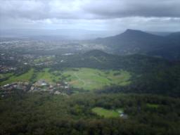
Telluride is the county seat and most populous town of San Miguel County in the southwestern portion of the U.S. state of Colorado. The town is a former silver mining camp on the San Miguel River in the western San Juan Mountains. The first gold mining claim was made in the mountains above Telluride in 1875, and early settlement of what is now Telluride followed. The town was founded in 1878 as "Columbia", but due to confusion with a California town of the same name, was renamed Telluride in 1887 for the gold telluride minerals found in other parts of Colorado. These telluride minerals were never found near Telluride, but the area's mines for some years provided zinc, lead, copper, silver, and other gold ores.

A ghost town, deserted city, extinct town, or abandoned city is an abandoned settlement, usually one that contains substantial visible remaining buildings and infrastructure such as roads. A town often becomes a ghost town because the economic activity that supported it has failed or ended for any reason. The town may also have declined because of natural or human-caused disasters such as floods, prolonged droughts, extreme heat or extreme cold, government actions, uncontrolled lawlessness, war, pollution, or nuclear and radiation accidents and incidents. The term can sometimes refer to cities, towns, and neighborhoods that, though still populated, are significantly less so than in past years; for example, those affected by high levels of unemployment and dereliction.

Silverton is a statutory town that is the county seat, the most populous community, and the only incorporated municipality in San Juan County, Colorado, United States. The town is located in a remote part of the western San Juan Mountains, a range of the Rocky Mountains. The first mining claims were made in mountains above the Silverton in 1860, near the end of the Colorado Gold Rush and when the land was still controlled by the Utes. Silverton was established shortly after the Utes ceded the region in the 1873 Brunot Agreement, and the town boomed from silver mining until the Panic of 1893 led to a collapse of the silver market, and boomed again from gold mining until the recession caused by the Panic of 1907. The entire town is included as a federally designated National Historic Landmark District, the Silverton Historic District.
Mount Kembla is a suburb and a mountain in the Illawarra region of New South Wales, Australia.

Zamora Chinchipe, Province of Zamora Chinchipe is a province of the Republic of Ecuador, located at the southeastern end of the Amazon Basin, which shares borders with the Ecuadorian provinces of Azuay and Morona Santiago to the north, Loja and Azuay to the west, and with Peru to the east and south. The province comprises an area of approximately 10,559 km² and is covered with a uniquely mountainous topography which markedly distinguishes it from the surrounding Amazonian provinces. Zamora-Chinchipe is characterized and largely identified by its mining industry; indigenous ethnic groups with a rich archaeological legacy; its biodiversity; and its niche and tourist attractions, which include a number of waterfalls well-noted for their beauty. The province takes its name from the bureaucratic fusion of the Zamora and Chinchipe cantons. The provincial capital is the city of Zamora.
A mining accident is an accident that occurs during the process of mining minerals or metals. Thousands of miners die from mining accidents each year, especially from underground coal mining, although accidents also occur in hard rock mining. Coal mining is considered much more hazardous than hard rock mining due to flat-lying rock strata, generally incompetent rock, the presence of methane gas, and coal dust. Most of the deaths these days occur in developing countries, and rural parts of developed countries where safety measures are not practiced as fully. A mining disaster is an incident where there are five or more fatalities.

A spoil tip is a pile built of accumulated spoil – waste material removed during mining. Spoil tips are not formed of slag, but in some areas, such as England and Wales, they are referred to as slag heaps. In Scotland the word bing is used. In North American English the term is mine dump or mine waste dump.

The Frank Slide was a massive rockslide that buried part of the mining town of Frank in the District of Alberta of the North-West Territories, Canada, at 4:10 a.m. on April 29, 1903. Around 44 million cubic metres/110 million tonnes of limestone rock slid down Turtle Mountain. Witnesses reported that within 100 seconds the rock reached up the opposing hills, obliterating the eastern edge of Frank, the Canadian Pacific Railway (CPR) line and the coal mine. It was one of the largest landslides in Canadian history and remains the deadliest, as between 70 and 90 of the town's residents died, most of whom remain buried in the rubble. Multiple factors led to the slide: Turtle Mountain's formation left it in a constant state of instability. Coal mining operations may have weakened the mountain's internal structure, as did a wet winter and cold snap on the night of the disaster.

Thistle is a ghost town in Spanish Fork Canyon in southeastern Utah County, Utah, United States. During the era of steam locomotives, the town's primary industry was servicing trains for the Denver and Rio Grande Western Railroad. The fortunes of the town were closely linked with those of the railroad until the changeover to diesel locomotives, when the town started to decline.
The Cordillera del Cóndor is a mountain range in the eastern Andes that is shared by and part of the international border between Ecuador and Peru.
Kembla Heights is a village west of Wollongong, New South Wales in the Parish of Kembla County of Camden. It is situated along Harry Graham Drive and upper Cordeaux Road and is part of a tourist route that runs along the Illawarra escarpment for a distance between Mount Kembla and Mount Keira. The Dendrobium Colliery is located in Kembla Heights.

Hpakant is a town in Hpakant Township, Kachin State in the northernmost part of Myanmar (Burma). It is located on the Uyu River 350 km north of Mandalay. It is famous for its jade mines which produce the world's best quality jadeite.

Tlalpujahua is a town and municipality located in the far northeast of the state of Michoacán in central Mexico. It is a former mining town, home of the Dos Estrellas Mine, which was the leading producer of gold in the early 20th century. A major landslide of mud and mining debris damaged this mine and buried about one-third of the town in 1937. Mining continued until 1959, but nationalization of the mine by President Cardenas in the 1930s led to the demise of the mine and impoverishment of the town. In the 1960s, a local by the name of Joaquín Muñoz Orta began making Christmas tree ornaments here. This eventually grew into what is now one of the largest producers of ornaments called Adornos Navideños SA de CV. In addition to this and another factory, there are about 150 small workshops dedicated to making Christmas items, with about 70% of the town's economy based on it.

Angangueo is a municipality located in far eastern Michoacán state in central Mexico noted for its history of mining and its location in the Monarch Butterfly Biosphere Reserve. The municipal seat is the Mineral de Angangueo. It is located in high rugged forested mountains, with the town in a small canyon.

The Trout Creek Mountains are a remote, semi-arid Great Basin mountain range mostly in southeastern Oregon and partially in northern Nevada in the United States. The range's highest point is Orevada View Benchmark, 8,506 feet (2,593 m) above sea level, in Nevada. Disaster Peak, elevation 7,781 feet (2,372 m), is another prominent summit in the Nevada portion of the mountains.

Qullissat is a former settlement in the Qeqertalik municipality, located on the northeast coast of Disko Island on the west coast of Greenland. It was a coal mining town founded to exploit the natural resources of Disko Island. The mines operated for 48 years until 1972, when the economic base of the settlement collapsed, leading to its abandonment.

Corriente Resources was a multinational corporation based in Canada that completed feasibility studies and environmental impact assessments (EIA) for open-pit copper mines in the Ecuadorian rainforest, including the Mirador mine. The Mirador mine is the first industrial scale copper mine to be developed in Ecuador. Corriente Resources also completed explorations of the San Carlos Panantza mine, although development of that project was halted in 2020 by Indigenous opposition.
The Mirador mine is a large copper mine located in the Amazonian province of Zamora-Chinchipe in southern Ecuador. It is one of the largest copper reserves in Ecuador, and the first industrial-scale copper project to be developed in the country. The project has generated an environmental conflict that is emblematic in the national political debate on mining.
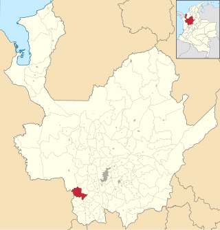
On May 18, 2015 a major landslide hit the town of Salgar, in Antioquia, Colombia. At least 78 people died in the disaster, making it the deadliest single-event disaster in Colombia since the 1999 Armenia, Colombia earthquake.
On 2 July 2020, a major landslide at the Wai Khar jade mining site in the Hpakant area of Kachin State, Myanmar, killed between 175 and 200 miners in the country's deadliest-ever mining accident. At 06:30 local time (MMT) heavy rains triggered the collapse of a heap of mining waste, which came tumbling down into a lake. This generated a 6.1-meter (20 ft) wave of mud and water that buried those working at the Wai Khar mine. The miners killed or injured by the landslide were independent "jade pickers", who scavenge tailings from larger operators and who live in ramshackle quarters at the base of large mounds of rubble.


