Nandigram

Last updated

Nandigram
Census town
West Bengal location map.svg
Red pog.svg
Nandigram
Location in West Bengal, India
India location map 3.png
Red pog.svg
Nandigram
Nandigram (India)
Coordinates: 22°01′N87°59′E / 22.01°N 87.99°E / 22.01; 87.99
CountryFlag of India.svg  India
State West Bengal
District Purba Medinipur
Area
  Total2.5577 km2 (0.9875 sq mi)
Elevation
6 m (20 ft)
Population
 (2011)
  Total5,803
  Density2,300/km2 (5,900/sq mi)
Languages
  Official Bengali, English
Time zone UTC+5:30 (IST)
Vehicle registration WB
Lok Sabha constituency Tamluk
Vidhan Sabha constituency Nandigram
Website purbamedinipur.gov.in

Nandigram is a census town in the Nandigram I Community Development Block of the Haldia subdivision in the Purba Medinipur district of the Indian state of West Bengal. [1]

Contents

In 2007, the West Bengal government allowed the Salim Group to set up a chemical hub at Nandigram under the special economic zone policy. [2] This led to resistance by the villagers resulting in clashes with the police that left 14 villagers dead, and resulted in accusations of police brutality.

Geography

Nandigram
Cities and towns in Haldia subdivision of Purba Medinipur district
M: municipal city/town, CT: census town, R: rural/urban centre, S: port
Owing to space constraints in the small map, the actual locations in a larger map may vary slightly

Police station

Nandigram's police station has jurisdiction over the Nandigram I and Nandigram II community development blocks. Nandigram's police station covers an area of 251.25km2 with a population of 279,285. [3] [4]

Urbanisation

79.19% of the Haldia subdivision's population lives in rural areas. Only 20.81% of the population lives in urban areas, and that is the highest proportion of urban population amongst the four subdivisions in the Purba Medinipur district. [5]

Note: The map alongside presents some of the notable locations in the subdivision. All places marked in the map are linked in the larger full screen map.

Demographics

According to the 2011 Census of India, Nandigram had a total population of 5,803 of which 2,947 (51%) were males and 2,856 (49%) were females. There were 725 people below the age of 6. The total number of literate people in Nandigram was 4,512 (88.85% of the population over 6 years old). [6]

Notable people

Late Trailakyanath Nanda,with Late Giribala Devi.jpg

Although this part of Bengal has not been actively highlighted in Indian history during the British period, the area had been a part of active politics from the British era. With the help of the people of Nandigram, "Tamluk" was freed from the British by Bhupal Chandra Panda, Ajoy Mukherjee, Sushil Kumar Dhara, Satish Chandra Samanta and their friends for a few days (which is the only part of modern India to be freed twice), before India gained independence in 1947.

In post-Independent India, Nandigram had been a centre of learning and played a major part in the development of Haldia, a satellite town of Calcutta (Kolkata). Fresh vegetables, rice and fish are supplied to Haldia from Nandigram. The Ganga (Bhagirathi) and Haldi (downstream of Kanshabati) cover the edges of Nandigram, and the land is fertilized by both the rivers.

Controversies

Transport

There is no rail connection directly to Nandigram, and roadways are moderately developed. Buses, jitney trekkers and van rickshaws are the primary public vehicles inside the villages.

The nearest railway station is Mograjpur, connecting from Digha - Tamluk. The nearest busy bus stop is in Math Chandipur.

Nandigram is connected to Haldia by a ferry. This ferry service is an important mode of transport for farmers and small traders from Nandigram, who use this service to reach Haldia's market to sell their commodities. Haldia Municipality runs this ferry service. [7]

Education

Sitananda College, Nandigram Sitananda College's Image.jpg
Sitananda College, Nandigram

Nandigram boasts a diverse educational landscape, catering to students from preschool to higher education. Five primary schools provide the foundation for learning, while the town's Secondary School, Nandigram BM Girls High School, caters to middle school needs. For higher secondary education, students can attend Nandigram BMT Sikshaniketan. Additionally, several private KG schools offer early childhood education options. Higher education is represented by Sitananda College, also known as Nandigram College, which is affiliated to Vidyasagar University.

Healthcare

Nandigram SSH/DH Nandigram SSH.jpg
Nandigram SSH/DH

In Nandigram, Nandigram Super Speciality Hospital serves as the town's main medical facility for specialized care. [8] [9] Additionally, two private nursing homes offer further options for medical needs.

See also

Related Research Articles

<span class="mw-page-title-main">Purba Medinipur district</span> District in West Bengal, India

Purba Medinipur district is an administrative unit in the Indian state of West Bengal. It is the southernmost district of Medinipur division – one of the five administrative divisions of West Bengal. The headquarters in Tamluk. It was formed on 1 January 2002 after the Partition of Medinipur into Purba Medinipur and Paschim Medinipur which lies at the northern and western border of it. The state of Odisha is at the southwest border; the Bay of Bengal lies in the south; the Hooghly river and South 24 Parganas district to the east; Howrah district to the north-east; Paschim Medinipur district to the west.

<span class="mw-page-title-main">Ramnagar I</span> Community development block in West Bengal, India

Ramnagar I is a community development block that forms an administrative division in Contai subdivision of Purba Medinipur district in the Indian state of West Bengal.

<span class="mw-page-title-main">Tamluk subdivision</span> Subdivision in West Bengal, India

Tamluk subdivision is a subdivision of the Purba Medinipur district in the state of West Bengal, India. It under Burdwan division.

<span class="mw-page-title-main">Haldia subdivision</span> Subdivision in West Bengal, India

Haldia subdivision is a subdivision of the Purba Medinipur district in the state of West Bengal, India.

<span class="mw-page-title-main">Mahishadal (community development block)</span> Community development block in West Bengal, India

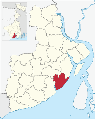
Mahishadal is a community development block that forms an administrative division in Haldia subdivision of Purba Medinipur district in the Indian state of West Bengal.

<span class="mw-page-title-main">Sutahata (community development block)</span> Community development block in West Bengal, India

Sutahata is a community development block that forms an administrative division in Haldia subdivision of Purba Medinipur district in the Indian state of West Bengal. In earlier days this block was referred to as Sutahata I block, and Haldia block was referred to as Sutahata II block.

<span class="mw-page-title-main">Chandipur (community development block)</span> Community development block in West Bengal, India

Chandipur is a community development block that forms an administrative division in Tamluk subdivision of Purba Medinipur district in the Indian state of West Bengal.

<span class="mw-page-title-main">Nandakumar (community development block)</span> Community development block in West Bengal, India

Nandakumar is a community development block that forms an administrative division in Tamluk subdivision of Purba Medinipur district in the Indian state of West Bengal.

<span class="mw-page-title-main">Tamluk (community development block)</span> Community development block in West Bengal, India

Tamluk is a community development block that forms an administrative division in Tamluk subdivision of Purba Medinipur district in the Indian state of West Bengal.

<span class="mw-page-title-main">Sahid Matangini (community development block)</span> Community development block in West Bengal, India

Sahid Matangini is a community development block that forms an administrative division in Tamluk subdivision of Purba Medinipur district in the Indian state of West Bengal.

Chandipur is a village, in Chandipur CD block in Tamluk subdivision of Purba Medinipur district in the state of West Bengal, India.

<span class="mw-page-title-main">Mahishadal</span> Town in West Bengal, India

Mahishadal is a town in Mahishadal CD block in Haldia subdivision of Purba Medinipur district in the state of West Bengal, India.

<span class="mw-page-title-main">Nandigram I</span> Community development block in West Bengal, India

Nandigram I is a community development block that forms an administrative division in Haldia subdivision of Purba Medinipur district in the Indian state of West Bengal.

<span class="mw-page-title-main">Nandigram II</span> Community development block in West Bengal, India

Nandigram II is a community development block that forms an administrative division in Haldia subdivision of Purba Medinipur district in the Indian state of West Bengal.

<span class="mw-page-title-main">Haldia (community development block)</span> Community development block in West Bengal, India

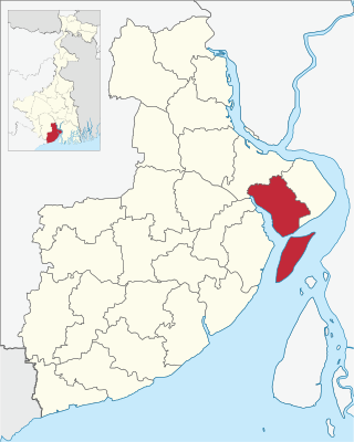
Haldia is a community development block that forms an administrative division in Haldia subdivision of Purba Medinipur district in the Indian state of West Bengal. In earlier days this block was referred to as Sutahata II block, and Sutahata block was referred to as Sutahata I block.

<span class="mw-page-title-main">Khejuri I</span> Community development block in West Bengal, India

Khejuri I is a community development block that forms an administrative division in Contai subdivision of Purba Medinipur district in the Indian state of West Bengal.

<span class="mw-page-title-main">Khejuri II</span> Community development block in West Bengal, India

Khejuri II is a Community Development Block that forms an administrative division in Contai subdivision of Purba Medinipur district in the Indian state of West Bengal.

Chatara is a village, in Sahid Matangini CD block in Tamluk subdivision of Purba Medinipur district in the state of West Bengal, India.

Nandakumar is a village in Nandakumar CD block in Tamluk subdivision of Purba Medinipur district in the state of West Bengal, India.

Reyepara is a village, in Nandigram II CD Block in Haldia subdivision of Purba Medinipur district in the state of West Bengal, India.

References

  1. "Haldia Development Authority". Archived from the original on 31 October 2006. Retrieved 5 January 2007.
  2. The Telegraph - Calcutta : Frontpage Story on Nandigram
  3. "District Statistical Handbook 2014 Purba Medinipur". Tables 2.1, 2.2. Department of Statistics and Programme Implementation, Government of West Bengal. Archived from the original on 29 July 2017. Retrieved 10 November 2016.
  4. "Nandigram PS". Purba Medinipur District Police. Retrieved 10 November 2016.
  5. "District Statistical Handbook 2014 Purba Medinipur". Table 2.2. Department of Planning and Statistics, Government of West Bengal. Archived from the original on 21 January 2019. Retrieved 21 April 2019.
  6. "C.D. Block Wise Primary Census Abstract Data(PCA)". 2011 census: West Bengal – District-wise CD Blocks. Registrar General and Census Commissioner, India. Retrieved 15 July 2016.
  7. Subhendu Ray, Kanchan Chakraborty and Kartik Panda (7 May 2007). "Without the ferry, Nandigram remains cut off". Indian Express. Archived from the original on 5 July 2009. Retrieved 27 October 2008.
  8. "A Speciality Mess". India Today. Retrieved 13 January 2024.
  9. "New seven super speciality hospital to be made in WB".