Related Research Articles

The Acasta Gneiss Complex, also called the Acasta Gneiss, is a body of felsic to ultramafic Archean basement rocks, gneisses, that form the northwestern edge of the Slave Craton in the Northwest Territories, Canada, about 300 km (190 mi) north of Yellowknife, Canada. This geologic complex consists largely of tonalitic and granodioritic gneisses and lesser amounts of mafic and ultramafic gneisses. It underlies and is largely concealed by thin, patchy cover of Quaternary glacial sediments over an area of about 13,000 km2 (5,000 sq mi). The Acasta Gneiss Complex contains fragments of the oldest known crust and record of more than a billion years of magmatism and metamorphism. The Acasta Gneiss Complex is exposed in a set of anticlinoriums within the foreland fold and thrust belt of the Paleoproterozoic Wopmay Orogen.

The Narryer Gneiss Terrane is a geological complex in Western Australia that is composed of a tectonically interleaved and polydeformed mixture of granite, mafic intrusions and metasedimentary rocks in excess of 3.3 billion years old, with the majority of the Narryer Gneiss Terrane in excess of 3.6 billion years old. The rocks have experienced multiple metamorphic events at amphibolite or granulite conditions, resulting in often complete destruction of original igneous or sedimentary (protolith) textures. Importantly, it contains the oldest known samples of the Earth's crust: samples of zircon from the Jack Hills portion of the Narryer Gneiss have been radiometrically dated at 4.4 billion years old, although the majority of zircon crystals are about 3.6-3.8 billion years old.

The Yilgarn Craton is a large craton that constitutes a major part of the Western Australian land mass. It is bounded by a mixture of sedimentary basins and Proterozoic fold and thrust belts. Zircon grains in the Jack Hills, Narryer Terrane have been dated at ~4.27 Ga, with one detrital zircon dated as old as 4.4 Ga.
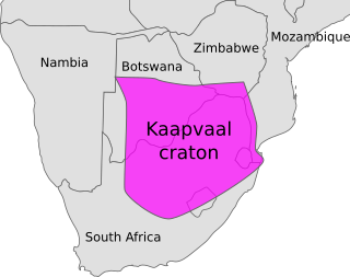
The Kaapvaal Craton, along with the Pilbara Craton of Western Australia, are the only remaining areas of pristine 3.6–2.5 Ga crust on Earth. Similarities of rock records from both these cratons, especially of the overlying late Archean sequences, suggest that they were once part of the Vaalbara supercontinent.

The geology of Antarctica covers the geological development of the continent through the Archean, Proterozoic and Phanerozoic eons.

The Limpopo Belt is located in South Africa and Zimbabwe, runs E-NE, and joins the Kaapvaal Craton to the south with the Zimbabwe Craton to the north. The belt is of high-grade metamorphic rocks that have undergone a long cycle of metamorphism and deformation that ended 2.0 billion years ago, after the stabilisation of the adjacent massifs. The belt comprises 3 components: the Central Zone, the North Marginal Zone and the South Marginal Zone.

The Kalahari Craton is a craton, an old and stable part of the continental lithosphere, that occupies large portions of South Africa, Botswana, Namibia and Zimbabwe. It consists of two cratons separated by the Limpopo Belt: the larger Kaapvaal Craton to the south and the smaller Zimbabwe Craton to the north. The Namaqua Belt is the southern margin of the Kaapvaal Craton.
In geology ultrahigh-temperature metamorphism (UHT) is extreme crustal metamorphism with metamorphic temperatures exceeding 900 °C. Granulite-facies rocks metamorphosed at very high temperatures were identified in the early 1980s, although it took another decade for the geoscience community to recognize UHT metamorphism as a common regional phenomenon. Petrological evidence based on characteristic mineral assemblages backed by experimental and thermodynamic relations demonstrated that Earth's crust can attain and withstand very high temperatures (900–1000 °C) with or without partial melting.

Mount Elkins, also known as Jökelen is a dark, steep-sided mountain with three major peaks, the highest 2,300 meters (7,500 ft) above sea level, in the Napier Mountains of Enderby Land. Enderby Land is part of East Antarctica and is claimed by Australia as part of the Australian Antarctic Territory. The mountain was named after Terence James Elkins, an ionospheric physicist with the Australian National Antarctic Research Expeditions at Mawson Station in 1960.

Ur is a hypothetical supercontinent that formed in the Archean eon around 3.1 billion years ago (Ga). In a reconstruction by Rogers, Ur is half a billion years older than Arctica and, in the early period of its existence, probably the only continent on Earth, making it a supercontinent despite probably being smaller than present-day Australia. In more recent works geologists often refer to both Ur and other proposed Archaean continental assemblages as supercratons. Ur can, nevertheless, be half a billion years younger than Vaalbara, but the concepts of these two early cratonic assemblages are incompatible.

The Lewisian complex or Lewisian gneiss is a suite of Precambrian metamorphic rocks that outcrop in the northwestern part of Scotland, forming part of the Hebridean Terrane and the North Atlantic Craton. These rocks are of Archaean and Paleoproterozoic age, ranging from 3.0–1.7 billion years (Ga). They form the basement on which the Torridonian and Moine Supergroup sediments were deposited. The Lewisian consists mainly of granitic gneisses with a minor amount of supracrustal rocks. Rocks of the Lewisian complex were caught up in the Caledonian orogeny, appearing in the hanging walls of many of the thrust faults formed during the late stages of this tectonic event.

The East Antarctic Shield or Craton is a cratonic rock body that covers 10.2 million square kilometers or roughly 73% of the continent of Antarctica. The shield is almost entirely buried by the East Antarctic Ice Sheet that has an average thickness of 2200 meters but reaches up to 4700 meters in some locations. East Antarctica is separated from West Antarctica by the 100–300 kilometer wide Transantarctic Mountains, which span nearly 3,500 kilometers from the Weddell Sea to the Ross Sea. The East Antarctic Shield is then divided into an extensive central craton that occupies most of the continental interior and various other marginal cratons that are exposed along the coast.

Enderby Land is a region of Northeastern Antarctica which extends into the Southern Indian Ocean. The area is claimed by Australia as part of the Australian Antarctic Territory. The unique and diverse geological features of this region have been associated with the evolution and development of the supercontinent Gondwana. Multiple distinct geological formations are located in this region. The most prominent and important are the
- Napier Complex (Archaean)
- Rayner Complex (late-Proterozoic)
- Lützow-Holm Complex (LHC) (early-Paleozoic)
- Yamato–Belgica Complex (early-Paleozoic)

The Aravalli Mountain Range is a northeast-southwest trending orogenic belt in the northwest part of India and is part of the Indian Shield that was formed from a series of cratonic collisions. The Aravalli Mountains consist of the Aravalli and Delhi fold belts, and are collectively known as the Aravalli-Delhi orogenic belt. The whole mountain range is about 700 km long. Unlike the much younger Himalayan section nearby, the Aravalli Mountains are believed much older and can be traced back to the Proterozoic Eon. They are arguably the oldest geological feature on Earth. The collision between the Bundelkhand craton and the Marwar craton is believed to be the primary mechanism for the development of the mountain range.

The Huangling Anticline or Complex represents a group of rock units that appear in the middle of the Yangtze Block in South China, distributed across Yixingshan, Zigui, Huangling, and Yichang counties. The group of rock involves nonconformity that sedimentary rocks overlie the metamorphic basement. It is a 73-km long, asymmetrical dome-shaped anticline with axial plane orientating in the north-south direction. It has a steeper west flank and a gentler east flank. Basically, there are three tectonic units from the anticline core to the rim, including Archean to Paleoproterozoic metamorphic basement, Neoproterozoic to Jurassic sedimentary rocks, and Cretaceous fluvial deposit sedimentary cover. The northern part of the core is mainly tonalite-trondhjemite-gneiss (TTG) and Cretaceous sedimentary rock called the Archean Kongling Complex. The middle of the core is mainly the Neoproterozoic granitoid. The southern part of the core is the Neoproterozoic potassium granite. Two basins are situated on the western and eastern flanks of the core, respectively, including the Zigui basin and Dangyang basin. Both basins are synforms while Zigui basin has a larger extent of folding. Yuanan Graben and Jingmen Graben are found within the Dangyang Basin area. The Huangling Anticline is an important area that helps unravel the tectonic history of the South China Craton because it has well-exposed layers of rock units from Archean basement rock to Cretaceous sedimentary rock cover due to the erosion of the anticline.

Eoarchean geology is the study of the oldest preserved crustal fragments of Earth during the Eoarchean era from 4.031 to 3.6 billion years ago. Major well-preserved rock units dated Eoarchean are known from three localities, the Isua Greenstone Belt in Southwest Greenland, the Acasta Gneiss in the Slave Craton in Canada, and the Nuvvuagittuq Greenstone Belt in the eastern coast of Hudson Bay in Quebec. From the dating of rocks in these three regions scientists suggest that plate tectonics could go back as early as Eoarchean.
The Mars Hill Terrane (MHT) is a belt of rocks exposed in the southern Appalachian Mountains, between Roan Mountain, North Carolina and Mars Hill, North Carolina. The terrane is located at the junction between the Western Blue Ridge and the Eastern Blue Ridge Mountains.

The Eastern Block of the North China Craton is one of the Earth's oldest pieces of continent. It is separated from the Western Block by the Trans-North China Orogen. It is situated in northeastern China and North Korea. The Block contains rock exposures older than 2.5 billion years. It serves as an ideal place to study how the crust was formed in the past and the related tectonic settings.

The Western Block of the North China Craton is an ancient micro-continental block mainly composed of Neoarchean and Paleoproterozoic rock basement, with some parts overlain by Cambrian to Cenozoic volcanic and sedimentary rocks. It is one of two sub-blocks within the North China Craton, located in east-central China. The boundaries of the Western Block are slightly different among distinct models, but the shapes and areas are similar. There is a broad consensus that the Western Block covers a large part of the east-central China.

The Dharwar Craton is an Archean continental crust craton formed between 3.6-2.5 billion years ago (Ga), which is located in southern India and considered as the oldest part of the Indian peninsula.
References
- 1 2 3 Harley, SL; Black, LP (1997). "A revised Archaean chronology for the Napier Complex, Enderby Land, from SHRIMP ion-microprobe studies". Antarctic Science. 9 (1): 74–91. doi:10.1017/S0954102097000102. ISSN 0954-1020.
- ↑ Lloyd G, Gibson M. "Geochronology of the Transantarctic Mountains". Tectonics of the Transantarctic Mountains. London: self-published. Archived from the original on May 4, 2003. Retrieved 2010-11-26.
- ↑ Lloyd G, Gibson M. "Crustal Formation sequence". Tectonics of the Transantarctic Mountains. London: self-published. Archived from the original on May 13, 2003. Retrieved 2010-11-26.
- 1 2 3 Choi SH, Mukasa SB, Andronikov AV, Osanai Y, Harley SL, Kelly NM (2006). "Lu Hf systematics of the ultra-high temperature Napier Metamorphic Complex in Antarctica: Evidence for the early Archean differentiation of Earth's mantle". Earth and Planetary Science Letters . 246 (3–4): 305–16. Bibcode:2006E&PSL.246..305C. doi:10.1016/j.epsl.2006.04.012. ISSN 0012-821X.
- ↑ Belyatsky, BV; Rodionov, NV; Sergeev, SA; Kamenev, EN (2007). Cooper, AK; Raymond, CR (eds.). New evidence for the early Archaean evolution of Aker Peaks, Napier Mountains, Enderby Land (East Antarctica) (PDF). Vol. Antarctica: A Keystone in a Changing World—Online Proceedings for the 10th International Symposium on Antarctic Earth Sciences. Santa Barbara, California: U.S. Geological Survey. pp. 187.1–4. ISBN 978-0-309-11854-5 . Retrieved 2010-11-26.
"Mount Elkins". Geographic Names Information System . United States Geological Survey, United States Department of the Interior . Retrieved 2010-11-26.