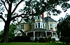
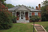
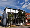
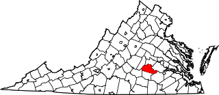
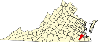
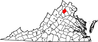
[3] Name on the Register [4] Image Date listed [5] Location City or town Description 1 Alleghany Springs Springhouse Alleghany Springs Springhouse November 13, 1989 (# 89001807 Alleghany Spring Rd. 37°07′40″N 80°15′51″W / 37.127778°N 80.264028°W / 37.127778; -80.264028 (Alleghany Springs Springhouse ) Alleghany Springs 2 Amiss-Palmer House Amiss-Palmer House November 13, 1989 (# 89001804 Mountain View Dr. and Penn St. off Eakin St. 37°13′36″N 80°24′26″W / 37.226667°N 80.407222°W / 37.226667; -80.407222 (Amiss-Palmer House ) Blacksburg 3 Barnett House Barnett House November 13, 1989 (# 89001810 U.S. Routes 11 /460 , 0.3 miles (0.48 km) south of their junction with Brake Rd. 37°12′39″N 80°14′00″W / 37.210972°N 80.233333°W / 37.210972; -80.233333 (Barnett House ) Elliston 4 William Barnett House William Barnett House November 13, 1989 (# 89001806 Off Alleghany Spring Rd., 0.1 miles (0.16 km) north of Georges Run Rd. 37°08′36″N 80°16′02″W / 37.143333°N 80.267222°W / 37.143333; -80.267222 (William Barnett House ) Alleghany Springs 5 Barracks No. 1 Barracks No. 1 November 19, 2014 (# 14000947 280 Alumni Mall 37°13′51″N 80°25′11″W / 37.23083°N 80.419722°W / 37.23083; -80.419722 (Barracks No. 1 ) Blacksburg Lane Hall on the Virginia Tech campus 6 Big Spring Baptist Church Big Spring Baptist Church November 13, 1989 (# 89001809 Brake Rd., 0.1 miles (0.16 km) east of U.S. Routes 11 /460 37°12′56″N 80°13′29″W / 37.215556°N 80.224861°W / 37.215556; -80.224861 (Big Spring Baptist Church ) Elliston 7 Bishop House Bishop House November 13, 1989 (# 89001812 0.1 miles (0.16 km) north of the junction of Graysontown and Lead Mine Rds. 37°02′17″N 80°33′19″W / 37.038056°N 80.555278°W / 37.038056; -80.555278 (Bishop House ) Graysontown 8 Blacksburg Historic District Blacksburg Historic District January 31, 1991 (# 90002165 Roughly the area north of the junction of Main and Jackson Sts., including sections out along Lee and Progress Sts. 37°13′51″N 80°24′48″W / 37.230833°N 80.413333°W / 37.230833; -80.413333 (Blacksburg Historic District ) Blacksburg 9 Blacksburg Motor Company, Inc. Blacksburg Motor Company, Inc. February 21, 2008 (# 08000074 400 S. Main St. 37°13′37″N 80°24′42″W / 37.226944°N 80.411667°W / 37.226944; -80.411667 (Blacksburg Motor Company, Inc. ) Blacksburg 10 Blankenship Farm Blankenship Farm November 13, 1989 (# 89001808 0.4 miles (0.64 km) south of the junction of Ellett and Sweeny Rds. 37°11′05″N 80°21′51″W / 37.184722°N 80.364167°W / 37.184722; -80.364167 (Blankenship Farm ) Ellett 11 Bowstring Truss Bridge Bowstring Truss Bridge January 2, 2013 (# 12001136 Ironto Rest Area on Interstate 81 37°14′21″N 80°13′28″W / 37.23921°N 80.22444°W / 37.23921; -80.22444 (Bowstring Truss Bridge ) Ironto 12 Bowyer-Trollinger Farm Bowyer-Trollinger Farm February 1, 1991 (# 90002167 Tyler Rd., north of its junction with Childress Rd. 37°04′02″N 80°30′24″W / 37.067361°N 80.506667°W / 37.067361; -80.506667 (Bowyer-Trollinger Farm ) Childress 13 Pompey Callaway House Pompey Callaway House November 13, 1989 (# 89001811 Calloway St., 0.2 miles (0.32 km) east of U.S. Routes 11 /460 37°13′00″N 80°13′48″W / 37.216667°N 80.230000°W / 37.216667; -80.230000 (Pompey Callaway House ) Elliston 14 Cambria Freight Station Cambria Freight Station December 12, 1985 (# 85003351 630 Depot St. 37°08′29″N 80°24′17″W / 37.141389°N 80.404722°W / 37.141389; -80.404722 (Cambria Freight Station ) Christiansburg 15 Cambria Historic District Cambria Historic District January 10, 1991 (# 90002002 500-600 blocks of Depot St., the 500-600 blocks of Montgomery St., the 900-1000 blocks of Cambria St., and railroad depots 37°08′35″N 80°24′19″W / 37.143056°N 80.405278°W / 37.143056; -80.405278 (Cambria Historic District ) Christiansburg 16 James Charlton Farm James Charlton Farm November 13, 1989 (# 89001816 Mud Pike east of State Route 177 37°05′50″N 80°29′49″W / 37.097361°N 80.496944°W / 37.097361; -80.496944 (James Charlton Farm ) Radford 17 Christiansburg Downtown Historic District Christiansburg Downtown Historic District May 28, 2013 (# 13000340 E. and W. Main St., and N. and S. Franklin St. 37°07′47″N 80°24′31″W / 37.129722°N 80.408611°W / 37.129722; -80.408611 (Christiansburg Downtown Historic District ) Christiansburg Thirty-two contributing buildings, one contributing site, and two contributing objects. [6] 18 Christiansburg Presbyterian Church Christiansburg Presbyterian Church January 30, 1978 (# 78003031 107 W. Main St. 37°07′43″N 80°24′39″W / 37.128611°N 80.410833°W / 37.128611; -80.410833 (Christiansburg Presbyterian Church ) Christiansburg 19 Crockett Springs Cottage Crockett Springs Cottage November 13, 1989 (# 89001814 1 mile (1.6 km) south of the junction of Alleghany Spring and Fishers View Rds. 37°05′38″N 80°15′07″W / 37.093889°N 80.251944°W / 37.093889; -80.251944 (Crockett Springs Cottage ) Piedmont 20 Cromer House Cromer House November 13, 1989 (# 89001893 Off Dry Valley Rd., 0.25 miles (0.40 km) east of Childress Rd. 37°03′07″N 80°31′34″W / 37.051944°N 80.526111°W / 37.051944; -80.526111 (Cromer House ) Childress 21 Currie House Currie House September 14, 1994 (# 94000549 1105 Highland Circle 37°13′26″N 80°23′38″W / 37.223889°N 80.393889°W / 37.223889; -80.393889 (Currie House ) Blacksburg 22 Earhart House Earhart House November 13, 1989 (# 89001801 Lusters Gate Rd., 0.3 miles (0.48 km) north of Sweeny Rd. 37°11′45″N 80°21′58″W / 37.195833°N 80.366111°W / 37.195833; -80.366111 (Earhart House ) Ellett 23 George Earhart House George Earhart House November 13, 1989 (# 89001886 Lusters Gate Rd., just north of Taylor Hollow Rd. 37°12′26″N 80°21′43″W / 37.207222°N 80.362083°W / 37.207222; -80.362083 (George Earhart House ) New Ellett 24 East Main Street Historic District East Main Street Historic District January 10, 1991 (# 90002008 E. Main St. from Roanoke and Pepper Sts. to the old high school, and Park St. from E. Main to Lester St. 37°07′58″N 80°24′19″W / 37.132778°N 80.405278°W / 37.132778; -80.405278 (East Main Street Historic District ) Christiansburg 25 Edgemont Church Edgemont Church November 13, 1989 (# 89001902 Mud Pike, 1 mile (1.6 km) east of Violet Dr. 37°06′28″N 80°28′44″W / 37.107778°N 80.478889°W / 37.107778; -80.478889 (Edgemont Church ) Christiansburg 26 Evans House No. 2 Evans House No. 2 November 13, 1989 (# 89001890 Prices Fork Rd., 0.5 miles (0.80 km) west of Merrimac Rd. 37°12′50″N 80°28′41″W / 37.213889°N 80.478194°W / 37.213889; -80.478194 (Evans House No. 2 ) Prices Fork 27 Fotheringay Fotheringay November 12, 1969 (# 69000262 South of the junction of U.S. Route 11 and Brake Rd. 37°11′45″N 80°13′51″W / 37.195833°N 80.230833°W / 37.195833; -80.230833 (Fotheringay ) Elliston 28 Nealy Gordon Farm Nealy Gordon Farm November 13, 1989 (# 89001805 Off Thacler Rd., 0.5 miles (0.80 km) south of the junction with North Fork Rd. 37°11′40″N 80°18′07″W / 37.194444°N 80.301806°W / 37.194444; -80.301806 (Nealy Gordon Farm ) Brush Harbor 29 John Grayson House John Grayson House November 13, 1989 (# 89001896 0.5 miles (0.80 km) northeast of the Graysontown Rd. bridge over the Little River 37°02′53″N 80°33′27″W / 37.047917°N 80.557500°W / 37.047917; -80.557500 (John Grayson House ) Graysontown 30 Grayson-Gravely House Grayson-Gravely House November 13, 1989 (# 89001813 Graysontown Rd. at the Little River bridge 37°02′36″N 80°33′45″W / 37.043333°N 80.562500°W / 37.043333; -80.562500 (Grayson-Gravely House ) Graysontown 31 Graysontown Methodist Church Graysontown Methodist Church November 13, 1989 (# 89001889 Graysontown Rd. 37°02′14″N 80°33′38″W / 37.037222°N 80.560556°W / 37.037222; -80.560556 (Graysontown Methodist Church ) Graysontown 32 Guerrant House Guerrant House November 13, 1989 (# 89001815 High Rock Hill Rd. at Old Pike Rd. 37°03′15″N 80°21′29″W / 37.054028°N 80.358056°W / 37.054028; -80.358056 (Guerrant House ) Pilot 33 Thomas Hall House Thomas Hall House November 13, 1989 (# 89001898 Tyler Rd., 0.5 miles (0.80 km) southeast of Stanley Rd. 37°04′40″N 80°30′43″W / 37.077778°N 80.511944°W / 37.077778; -80.511944 (Thomas Hall House ) Childress 34 Hornbarger Store Hornbarger Store November 13, 1989 (# 89001888 Vicker Switch Rd., 0.1 miles (0.16 km) east of Switchback Rd. 37°09′50″N 80°29′09″W / 37.163889°N 80.485833°W / 37.163889; -80.485833 (Hornbarger Store ) Vicker 35 Howard-Bell-Feather House Howard-Bell-Feather House November 13, 1989 (# 89001887 Union Valley Rd. at Elliott Creek 37°04′01″N 80°24′32″W / 37.0670833°N 80.408889°W / 37.0670833; -80.408889 (Howard-Bell-Feather House ) Riner 36 Keister House Keister House November 13, 1989 (# 89001880 607 Giles Rd. 37°14′25″N 80°25′01″W / 37.240278°N 80.416944°W / 37.240278; -80.416944 (Keister House ) Blacksburg 37 Kentland Farm Historic and Archeological District Kentland Farm Historic and Archeological District July 3, 1991 (# 91000833 At the end of Whitethorne Rd. along the New River ; also the western terminus of Whitethorne Rd. 37°11′42″N 80°34′46″W / 37.195000°N 80.579444°W / 37.195000; -80.579444 (Kentland Farm Historic and Archeological District ) Blacksburg Whitethorne Road represents a boundary increase of September 6, 2006 38 Michael Kinzer House Michael Kinzer House November 13, 1989 (# 89001901 Linwood Ln. 37°14′02″N 80°27′31″W / 37.233750°N 80.458611°W / 37.233750; -80.458611 (Michael Kinzer House ) Blacksburg 39 Lafayette Historic District Lafayette Historic District January 10, 1991 (# 90002005 Roughly High St. from Main to Washington Sts., Main from High to Water Sts., and Church St. from Main to Washington 37°14′07″N 80°12′39″W / 37.235278°N 80.210833°W / 37.235278; -80.210833 (Lafayette Historic District ) Lafayette 40 Frank Lawrence House Frank Lawrence House November 13, 1989 (# 89001897 High Rock Hill Rd., 0.2 miles (0.32 km) east of Tanbark Rd. 37°03′08″N 80°19′05″W / 37.052361°N 80.318056°W / 37.052361; -80.318056 (Frank Lawrence House ) Basham 41 Linkous-Kipps House Linkous-Kipps House November 13, 1989 (# 89001885 Merrimac Rd. 37°12′27″N 80°27′31″W / 37.207500°N 80.458611°W / 37.207500; -80.458611 (Linkous-Kipps House ) Merrimac 42 Edgar A. Long Building Edgar A. Long Building March 5, 2001 (# 01000149 140 Scattergood Dr. 37°08′33″N 80°25′03″W / 37.142500°N 80.417500°W / 37.142500; -80.417500 (Edgar A. Long Building ) Christiansburg 43 Madison Farm Historic and Archeological District Madison Farm Historic and Archeological District January 25, 1991 (# 90002190 Eastern and western sides of U.S. Route 460 north of the junction with Dark Run Rd. 37°11′01″N 80°14′06″W / 37.183611°N 80.235000°W / 37.183611; -80.235000 (Madison Farm Historic and Archeological District ) Elliston 44 Joseph McDonald Farm Joseph McDonald Farm February 1, 1991 (# 90002166 Walnut Spring Rd., northwest of the junction with Prices Fork Rd., at the end of a spur road 37°13′36″N 80°28′27″W / 37.226667°N 80.474167°W / 37.226667; -80.474167 (Joseph McDonald Farm ) Prices Fork 45 Miller-Southside Residential Historic District Miller-Southside Residential Historic District January 11, 1991 (# 90002110 Roughly bounded by Miller St., S. Main St., Airport Rd., and Preston Ave. 37°13′18″N 80°24′26″W / 37.221667°N 80.407222°W / 37.221667; -80.407222 (Miller-Southside Residential Historic District ) Blacksburg 46 Montgomery Primitive Baptist Church Montgomery Primitive Baptist Church November 13, 1989 (# 89001803 Triangle St., southwest of the junction with U.S. Route 460 Business 37°11′02″N 80°24′39″W / 37.183750°N 80.410833°W / 37.183750; -80.410833 (Montgomery Primitive Baptist Church ) Merrimac 47 North Fork Valley Rural Historic District North Fork Valley Rural Historic District February 1, 1991 (# 90002169 Along the North Fork of the Roanoke River from the Roanoke County line south to Lusters Gate 37°15′51″N 80°19′49″W / 37.264167°N 80.330278°W / 37.264167; -80.330278 (North Fork Valley Rural Historic District ) Blacksburg 48 The Oaks The Oaks July 15, 1994 (# 94000709 311 E. Main St. 37°08′00″N 80°24′16″W / 37.133472°N 80.404444°W / 37.133472; -80.404444 (The Oaks ) Christiansburg 49 Odd Fellows Hall Odd Fellows Hall July 27, 2005 (# 05000770 203 Gilbert St. 37°14′04″N 80°25′15″W / 37.234306°N 80.420833°W / 37.234306; -80.420833 (Odd Fellows Hall ) Blacksburg 50 Old Christiansburg Industrial Institute Old Christiansburg Industrial Institute April 6, 1979 (# 79003056 570 High St. 37°08′21″N 80°24′20″W / 37.139167°N 80.405556°W / 37.139167; -80.405556 (Old Christiansburg Industrial Institute ) Christiansburg 51 Phillips-Ronald House Phillips-Ronald House November 13, 1989 (# 89001904 Draper Rd. at Washington St. 37°13′37″N 80°24′49″W / 37.226944°N 80.413611°W / 37.226944; -80.413611 (Phillips-Ronald House ) Blacksburg 52 Phlegar Building Phlegar Building November 13, 1989 (# 89001892 2 S. Franklin St. 37°07′46″N 80°24′29″W / 37.129583°N 80.408056°W / 37.129583; -80.408056 (Phlegar Building ) Christiansburg 53 Piedmont Camp Meeting Grounds Historic District Piedmont Camp Meeting Grounds Historic District January 10, 1991 (# 90002003 Junction of Jewell Dr. and Miles Rd. 37°06′13″N 80°13′00″W / 37.103611°N 80.216667°W / 37.103611; -80.216667 (Piedmont Camp Meeting Grounds Historic District ) Piedmont 54 Pilot School Upload image February 7, 2024 (# 100009956 4449 Brush Creek Road /Route 617 37°03′02″N 80°21′43″W / 37.0506°N 80.3620°W / 37.0506; -80.3620 (Pilot School ) Pilot 55 Prices Fork Historic District Prices Fork Historic District January 10, 1991 (# 90002004 Prices Fork Rd. from Thomas Lane roughly to Brooksfield Rd.; also Prices Fork Rd. 37°12′35″N 80°29′27″W / 37.209722°N 80.490833°W / 37.209722; -80.490833 (Prices Fork Historic District ) Prices Fork Second location represents a boundary increase of August 25, 2014 56 Rife House Rife House November 13, 1989 (# 89001900 U.S. Routes 11 /460 at Dark Run Rd. 37°10′38″N 80°14′12″W / 37.177361°N 80.236667°W / 37.177361; -80.236667 (Rife House ) Shawsville 57 Riner Historic District Riner Historic District January 10, 1991 (# 90002006 Roughly east and south of the junction of Main and Franklin Sts. 37°04′00″N 80°26′24″W / 37.066667°N 80.440000°W / 37.066667; -80.440000 (Riner Historic District ) Riner 58 Shawsville Historic District Shawsville Historic District January 10, 1991 (# 90002009 Main St. east and west of the junction with Alleghany Spring Rd. 37°10′08″N 80°15′16″W / 37.168889°N 80.254444°W / 37.168889; -80.254444 (Shawsville Historic District ) Shawsville 59 Slusser-Ryan Farm Slusser-Ryan Farm August 28, 2017 (# 100001514 2028 Mt. Tabor Rd. 37°17′03″N 80°23′16″W / 37.284028°N 80.387778°W / 37.284028; -80.387778 (Slusser-Ryan Farm ) Blacksburg 60 Smithfield Smithfield November 12, 1969 (# 69000261 West of Blacksburg 37°13′05″N 80°25′55″W / 37.218056°N 80.432083°W / 37.218056; -80.432083 (Smithfield ) Blacksburg 61 Solitude Solitude May 5, 1989 (# 89000363 Greenhouse Rd. on the Virginia Tech campus 37°13′34″N 80°25′37″W / 37.226111°N 80.426944°W / 37.226111; -80.426944 (Solitude ) Blacksburg 62 South Franklin Street Historic District South Franklin Street Historic District January 10, 1991 (# 90002007 100-308 S. Franklin St. 37°07′40″N 80°24′22″W / 37.127778°N 80.406111°W / 37.127778; -80.406111 (South Franklin Street Historic District ) Christiansburg 63 Surface House Surface House November 13, 1989 (# 89001883 High St., east of Depot St. 37°08′21″N 80°24′29″W / 37.139028°N 80.408056°W / 37.139028; -80.408056 (Surface House ) Christiansburg 64 Trinity United Methodist Church Trinity United Methodist Church November 13, 1989 (# 89001894 Ellett Rd., 0.1 miles (0.16 km) south of Sweeny Rd. 37°11′19″N 80°22′06″W / 37.188611°N 80.368333°W / 37.188611; -80.368333 (Trinity United Methodist Church ) Ellett 65 US Post Office-Christiansburg US Post Office-Christiansburg February 1, 1991 (# 90002168 Northwestern corner of the public square 37°07′49″N 80°24′33″W / 37.130278°N 80.409167°W / 37.130278; -80.409167 (US Post Office-Christiansburg ) Christiansburg 66 Virginian Railway Underpass Virginian Railway Underpass November 13, 1989 (# 89001903 Junction of the Norfolk Southern railroad tracks and Lusters Gate Rd., south of New Ellett 37°11′58″N 80°21′50″W / 37.199583°N 80.363889°W / 37.199583; -80.363889 (Virginian Railway Underpass ) New Ellett 67 Adam Wall House Adam Wall House November 13, 1989 (# 89001891 Merrimac Rd., 0.5 miles (0.80 km) south of Prices Fork Rd. 37°12′28″N 80°28′03″W / 37.207778°N 80.467500°W / 37.207778; -80.467500 (Adam Wall House ) Prices Fork 68 Walnut Grove Farm Walnut Grove Farm January 17, 1991 (# 89001899 Boners Run Rd., 0.2 miles (0.32 km) southeast of U.S. Routes 11 /U.S. Route 460 37°10′06″N 80°14′49″W / 37.168333°N 80.246944°W / 37.168333; -80.246944 (Walnut Grove Farm ) Shawsville 69 Walnut Spring Walnut Spring November 13, 1989 (# 89001878 Glade Rd., 0.5 miles (0.80 km) east of the junction with Brooksfield Rd. 37°13′41″N 80°29′22″W / 37.228194°N 80.489444°W / 37.228194; -80.489444 (Walnut Spring ) Kanodes Mill 70 Whitethorn Whitethorn November 13, 1989 (# 89001879 Tall Oaks Dr. 37°12′30″N 80°27′04″W / 37.208472°N 80.451111°W / 37.208472; -80.451111 (Whitethorn ) Blacksburg 71 Yellow Sulphur Springs Yellow Sulphur Springs September 20, 1979 (# 79003057 North of Christiansburg on Yellow Sulphur Rd. 37°10′44″N 80°23′52″W / 37.178889°N 80.397778°W / 37.178889; -80.397778 (Yellow Sulphur Springs ) Christiansburg