National Register of Historic Places listings in Snyder County, Pennsylvania

Last updated
Location of Snyder County in Pennsylvania Map of Pennsylvania highlighting Snyder County.svg
Location of Snyder County in Pennsylvania

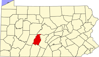
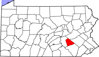
This is a list of the National Register of Historic Places listings in Snyder County, Pennsylvania.

Contents

This is intended to be a complete list of the properties and districts on the National Register of Historic Places in Snyder County, Pennsylvania, United States. The locations of National Register properties and districts for which the latitude and longitude coordinates are included below, may be seen in a map. [1]

National Register of Historic Places federal list of historic sites in the United States

The National Register of Historic Places (NRHP) is the United States federal government's official list of districts, sites, buildings, structures, and objects deemed worthy of preservation for their historical significance. A property listed in the National Register, or located within a National Register Historic District, may qualify for tax incentives derived from the total value of expenses incurred preserving the property.

Snyder County, Pennsylvania County in the United States

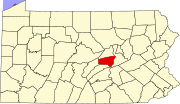
Snyder County is a county in the U.S. state of Pennsylvania. As of the 2010 census, the population was 39,702. The county seat is Middleburg. Snyder County was formed in 1855 from parts of Union County.

Pennsylvania State of the United States of America

Pennsylvania, officially the Commonwealth of Pennsylvania, is a state located in the northeastern, Great Lakes and Mid-Atlantic regions of the United States. The Appalachian Mountains run through its middle. The Commonwealth is bordered by Delaware to the southeast, Maryland to the south, West Virginia to the southwest, Ohio to the west, Lake Erie and the Canadian province of Ontario to the northwest, New York to the north, and New Jersey to the east.

There are 8 properties and districts listed on the National Register in the county. Two sites are further designated as National Historic Landmarks and another is designated as a National Historic Site.

National Historic Landmark formal designation assigned by the United States federal government to historic buildings and sites in the United States

A National Historic Landmark (NHL) is a building, district, object, site, or structure that is officially recognized by the United States government for its outstanding historical significance. Of over 90,000 places listed on the country's National Register of Historic Places, only some 2,500 are recognized as National Historic Landmarks.

This National Park Service list is complete through NPS recent listings posted May 11, 2018. [2]
Map all coordinates using: OpenStreetMap  ·  Google Maps
Download coordinates as: KML  ·  GPX

Current listings

[3] Name on the Register Image Date listed [4] Location City or town Description
1 Aline Covered Bridge
Aline Covered Bridge Aline Covered Bridge 1.JPG
Aline Covered Bridge
August 10, 1979
(#79002344)
Northwest of Meiserville
40°40′35″N76°58′46″W / 40.676389°N 76.979444°W / 40.676389; -76.979444 (Aline Covered Bridge)
Perry Township
2 Bridge between Monroe and Penn Townships
Bridge between Monroe and Penn Townships Bridge between Monroe and Penn Townships, original.jpg
Bridge between Monroe and Penn Townships
June 22, 1988
(#88000811)
Legislative Route 54013 over Penns Creek
40°49′32″N76°52′17″W / 40.825556°N 76.871389°W / 40.825556; -76.871389 (Bridge between Monroe and Penn Townships)
Monroe and Penn Townships Demolished and replaced with new bridge
3 Dreese's Covered Bridge
Dreese's Covered Bridge Dreese's Covered Bridge.jpg
Dreese's Covered Bridge
August 10, 1979
(#79002343)
Spans Middle Creek
40°46′31″N77°08′42″W / 40.775278°N 77.145°W / 40.775278; -77.145 (Dreese's Covered Bridge)
Beaver Township
4 East Oriental Covered Bridge
East Oriental Covered Bridge EAST ORIENTAL COVERED BRIDGE.jpg
East Oriental Covered Bridge
August 10, 1979
(#79002246)
Northeast of Oriental
40°38′20″N77°00′05″W / 40.638889°N 77.001389°W / 40.638889; -77.001389 (East Oriental Covered Bridge)
Perry Township Extends into Susquehanna Township in Juniata County
5 Gross Bridge
Gross Bridge Gross Covered Bridge 1.jpg
Gross Bridge
August 29, 1977
(#77001194)
Township Route 427 in Beaver Springs
40°45′06″N77°13′24″W / 40.751667°N 77.223333°W / 40.751667; -77.223333 (Gross Bridge)
Spring Township
6 North Oriental Covered Bridge
North Oriental Covered Bridge NORTH ORIENTAL COVERED BRIDGE.jpg
North Oriental Covered Bridge
August 10, 1979
(#79002247)
Northeast of Oriental
40°39′42″N77°00′41″W / 40.661667°N 77.011389°W / 40.661667; -77.011389 (North Oriental Covered Bridge)
Perry Township Extends into Susquehanna Township in Juniata County
7 Selinsgrove Hall and Seibert Hall
Selinsgrove Hall and Seibert Hall Seibert Hall Oct 09.JPG
Selinsgrove Hall and Seibert Hall
October 25, 1979
(#79002345)
Pine Street
40°47′56″N76°52′19″W / 40.798889°N 76.871944°W / 40.798889; -76.871944 (Selinsgrove Hall and Seibert Hall)
Selinsgrove
8 Gov. Simon Snyder Mansion
Gov. Simon Snyder Mansion Gov Simon Snyder Mansion Oct 09.JPG
Gov. Simon Snyder Mansion
August 25, 1978
(#78002470)
119121 North Market Street
40°48′02″N76°51′43″W / 40.800556°N 76.861944°W / 40.800556; -76.861944 (Gov. Simon Snyder Mansion)
Selinsgrove

See also

Related Research Articles

National Register of Historic Places listings in Berks County, Pennsylvania Wikimedia list article

This is a list of the National Register of Historic Places listings in Berks County, Pennsylvania.

National Register of Historic Places listings in Delaware County, Pennsylvania Wikimedia list article

This is a list of the National Register of Historic Places listings in Delaware County, Pennsylvania.

National Register of Historic Places listings in Fayette County, Pennsylvania Wikimedia list article

This is a list of the National Register of Historic Places listings in Fayette County, Pennsylvania.

National Register of Historic Places listings in Washington County, Pennsylvania Wikimedia list article

This is a list of the National Register of Historic Places listings in Washington County, Pennsylvania.

National Register of Historic Places listings in York County, Pennsylvania Wikimedia list article

This is a list of the National Register of Historic Places listings in York County, Pennsylvania.

National Register of Historic Places listings in Dauphin County, Pennsylvania Wikimedia list article

This is a list of the National Register of Historic Places listings in Dauphin County, Pennsylvania.

National Register of Historic Places listings in Bedford County, Pennsylvania Wikimedia list article

This is a list of the National Register of Historic Places listings in Bedford County, Pennsylvania.

National Register of Historic Places listings in Blair County, Pennsylvania Wikimedia list article

This is a list of the National Register of Historic Places listings in Blair County, Pennsylvania.

National Register of Historic Places listings in Butler County, Pennsylvania Wikimedia list article

This is a list of the National Register of Historic Places listings in Butler County, Pennsylvania.

National Register of Historic Places listings in Carbon County, Pennsylvania Wikimedia list article

This is a list of the National Register of Historic Places listings in Carbon County, Pennsylvania.

National Register of Historic Places listings in Centre County, Pennsylvania Wikimedia list article

This is a list of the National Register of Historic Places listings in Centre County, Pennsylvania.

National Register of Historic Places listings in Lackawanna County, Pennsylvania Wikimedia list article

This is a list of the National Register of Historic Places listings in Lackawanna County, Pennsylvania.

National Register of Historic Places listings in Lebanon County, Pennsylvania Wikimedia list article

This is a list of the National Register of Historic Places listings in Lebanon County, Pennsylvania.

National Register of Historic Places listings in Lehigh County, Pennsylvania Wikimedia list article

This is a list of the National Register of Historic Places listings in Lehigh County, Pennsylvania.

National Register of Historic Places listings in Northumberland County, Pennsylvania Wikimedia list article

This is a list of the National Register of Historic Places listings in Northumberland County, Pennsylvania.

National Register of Historic Places listings in Pike County, Pennsylvania Wikimedia list article

This is a list of the National Register of Historic Places listings in Pike County, Pennsylvania.

National Register of Historic Places listings in Schuylkill County, Pennsylvania Wikimedia list article

This is a list of the National Register of Historic Places listings in Schuylkill County, Pennsylvania.

National Register of Historic Places listings in Somerset County, Pennsylvania Wikimedia list article

This is a list of the National Register of Historic Places listings in Somerset County, Pennsylvania.

National Register of Historic Places listings in Wayne County, Pennsylvania Wikimedia list article

This is a list of the National Register of Historic Places listings in Wayne County, Pennsylvania.

National Register of Historic Places listings in Westmoreland County, Pennsylvania Wikimedia list article

This is a list of the National Register of Historic Places listings in Westmoreland County, Pennsylvania.

References

  1. The latitude and longitude information provided in this table was derived originally from the National Register Information System, which has been found to be fairly accurate for about 99% of listings. For about 1% of NRIS original coordinates, experience has shown that one or both coordinates are typos or otherwise extremely far off; some corrections may have been made. A more subtle problem causes many locations to be off by up to 150 yards, depending on location in the country: most NRIS coordinates were derived from tracing out latitude and longitudes off of USGS topographical quadrant maps created under the North American Datum of 1927 , which differs from the current, highly accurate WGS84 GPS system used by most on-line maps. Chicago is about right, but NRIS longitudes in Washington are higher by about 4.5 seconds, and are lower by about 2.0 seconds in Maine. Latitudes differ by about 1.0 second in Florida. Some locations in this table may have been corrected to current GPS standards.
  2. "National Register of Historic Places: Weekly List Actions". National Park Service, United States Department of the Interior. Retrieved on May 11, 2018.
  3. Numbers represent an ordering by significant words. Various colorings, defined here, differentiate National Historic Landmarks and historic districts from other NRHP buildings, structures, sites or objects.
  4. The eight-digit number below each date is the number assigned to each location in the National Register Information System database, which can be viewed by clicking the number.