National Register of Historic Places listings in Pike County, Pennsylvania

Last updated

Location of Pike County in Pennsylvania Map of Pennsylvania highlighting Pike County.svg
Location of Pike County in Pennsylvania

This is a list of the National Register of Historic Places listings in Pike County, Pennsylvania.

Contents

This is intended to be a complete list of the properties and districts on the National Register of Historic Places in Pike County, Pennsylvania, United States. The locations of National Register properties and districts for which the latitude and longitude coordinates are included below, may be seen in a map. [1]

There are 27 properties and districts listed on the National Register in the county. Two sites are further designated as National Historic Landmarks and another is designated as a National Historic Site.


    This National Park Service list is complete through NPS recent listings posted December 8, 2023. [2]

Map all coordinates using: OpenStreetMap

Current listings

[3] Name on the RegisterImageDate listed [4] Location City or townDescription
1 Brodhead Farm
Brodhead Farm Brodhead Farm Wheat Plains House NPS.jpg
Brodhead Farm
July 23, 1979
(#79000242)
Northeast of Bushkill on U.S. Route 209
41°08′59″N74°55′12″W / 41.149722°N 74.92°W / 41.149722; -74.92 (Brodhead Farm)
Lehman Township
2 Callahan House
Callahan House Callahan House DWG NPS.jpg
Callahan House
July 23, 1979
(#79000244)
U.S. Route 209, south of Milford
41°19′00″N74°48′01″W / 41.316667°N 74.800278°W / 41.316667; -74.800278 (Callahan House)
Dingman Township
3 D & H Canal Co. Office
D & H Canal Co. Office D & H Canal Co House, Lackawaxen, PA.jpg
D & H Canal Co. Office
August 9, 1993
(#93000715)
Northwestern side of Scenic Drive in Lackawaxen
41°29′01″N74°59′13″W / 41.483611°N 74.986944°W / 41.483611; -74.986944 (D & H Canal Co. Office)
Lackawaxen Township Intact 1855 house built as local office for canal; now used as bed and breakfast
4 Delaware and Hudson Canal
Delaware and Hudson Canal Delaware and Hudson Canal near Summitville, NY.jpg
Delaware and Hudson Canal
November 24, 1968
(#68000051)
Delaware and Hudson Canal
41°28′56″N74°59′09″W / 41.482222°N 74.985833°W / 41.482222; -74.985833 (Delaware and Hudson Canal)
Lackawaxen Township Extends into Wayne County
5 Delaware Aqueduct
Delaware Aqueduct RoeblingDelawareAqueduct.jpg
Delaware Aqueduct
November 24, 1968
(#68000055)
Between Minisink Ford, New York and Lackawaxen
41°28′57″N74°59′06″W / 41.482500°N 74.985000°W / 41.482500; -74.985000 (Delaware Aqueduct)
Lackawaxen Township
6 Dingman's Ferry Dutch Reformed Church
Dingman's Ferry Dutch Reformed Church Dingman's Ferry Dutch Reformed Church.jpg
Dingman's Ferry Dutch Reformed Church
July 23, 1979
(#79000241)
U.S. Route 209 in Dingman's Ferry
41°13′32″N74°52′10″W / 41.225556°N 74.869444°W / 41.225556; -74.869444 (Dingman's Ferry Dutch Reformed Church)
Delaware Township
7 Forester's Hall
Forester's Hall Forest Hall Milford PA.jpg
Forester's Hall
July 14, 1983
(#83002282)
Broad and Hartford Streets
41°19′21″N74°48′14″W / 41.3225°N 74.803889°W / 41.3225; -74.803889 (Forester's Hall)
Milford
8 Jervis Gordon Grist Mill Historic District
Jervis Gordon Grist Mill Historic District Jervis Gordon grist mill from N 1.jpg
Jervis Gordon Grist Mill Historic District
December 26, 1985
(#85003163)
Water, Mill, and Seventh Streets
41°19′26″N74°48′40″W / 41.323889°N 74.811111°W / 41.323889; -74.811111 (Jervis Gordon Grist Mill Historic District)
Milford
9 Zane Grey House
Zane Grey House Zane Grey House, Lackawaxen, PA.jpg
Zane Grey House
May 6, 1983
(#83002283)
Roebling Road in Lackawaxen; also 135 Lackawaxen Scenic Dr.
41°29′08″N74°59′16″W / 41.485556°N 74.987778°W / 41.485556; -74.987778 (Zane Grey House)
Lackawaxen Township Self-designed 1905–18 home of the novelist; wrote Riders of the Purple Sage here. Now museum run by the National Park Service. Scenic Drive represents a boundaries increase of April 29, 2011
10 Hotel Fauchere and Annex
Hotel Fauchere and Annex Hotel Fauchere front Milford PA.jpg
Hotel Fauchere and Annex
August 29, 1980
(#80003626)
401 and 403 Broad Street
41°19′25″N74°48′05″W / 41.323611°N 74.801389°W / 41.323611; -74.801389 (Hotel Fauchere and Annex)
Milford
11 Lord House
Lord House Lord House (2).JPG
Lord House
June 30, 1980
(#80003625)
Pennsylvania Route 739 at Lords Valley
41°22′04″N75°03′49″W / 41.367778°N 75.063611°W / 41.367778; -75.063611 (Lord House)
Blooming Grove Township
12 Metz Ice Plant
Metz Ice Plant Metz Ice Plant DWG NPS.jpg
Metz Ice Plant
November 19, 2007
(#07001206)
Harford Street
41°19′02″N74°47′59″W / 41.317222°N 74.799722°W / 41.317222; -74.799722 (Metz Ice Plant)
Milford
13 Milford Historic District
Milford Historic District Milford Community House Public Library 3264px.jpg
Milford Historic District
July 23, 1998
(#98000898)
Roughly along Broad, Harford, Ann, Catharine, High, and Fourth Streets
41°19′23″N74°48′08″W / 41.323056°N 74.802222°W / 41.323056; -74.802222 (Milford Historic District)
Milford
14 Mill Rift Hall
Mill Rift Hall Mill Rift Hall (3).JPG
Mill Rift Hall
August 9, 1993
(#93000714)
Bluestone Boulevard
41°24′42″N74°44′45″W / 41.411667°N 74.745833°W / 41.411667; -74.745833 (Mill Rift Hall)
Westfall Township
15 Minisink Archeological Site
Minisink Archeological Site Manna site cut bank 1.jpg
Minisink Archeological Site
April 19, 1993
(#93000608)
In the vicinity of Minisink Island [5]
41°17′26″N74°49′44″W / 41.2906°N 74.829°W / 41.2906; -74.829 (Minisink Archeological Site)
Dingman Township Extends into Sussex County, New Jersey
16 Nearpass House
Nearpass House Nearpass House (1).JPG
Nearpass House
August 19, 1993
(#93000849)
Cemetery Road
41°25′07″N74°44′30″W / 41.418611°N 74.741667°W / 41.418611; -74.741667 (Nearpass House)
Westfall Township
17 Nyce Farm
Nyce Farm William Nyce House.jpg
Nyce Farm
July 23, 1979
(#79000240)
Northwest of Bushkill on U.S. Route 209
41°08′24″N74°55′50″W / 41.14°N 74.930556°W / 41.14; -74.930556 (Nyce Farm)
Lehman Township
18 Paupack School
Paupack School PAUPACK SCHOOL, PALMYRA TWP, PIKE COUNTY, PA.jpg
Paupack School
August 29, 2016
(#16000573)
545 Pennsylvania Route 507
41°24′28″N75°13′38″W / 41.407639°N 75.227322°W / 41.407639; -75.227322 (Paupack School)
Palmyra Township
19 Peters House
Peters House Peters House DWG NPS.jpg
Peters House
August 24, 1979
(#79000239)
U.S. Route 209 in Bushkill
41°05′36″N75°00′08″W / 41.093333°N 75.002222°W / 41.093333; -75.002222 (Peters House)
Lehman Township
20 Pike County Courthouse
Pike County Courthouse Pike County Courthouse Milford PA.jpg
Pike County Courthouse
July 23, 1979
(#79002340)
Broad and High Streets
41°19′28″N74°48′04″W / 41.324444°N 74.801111°W / 41.324444; -74.801111 (Pike County Courthouse)
Milford
21 Gifford Pinchot House
Gifford Pinchot House Grey Towers National Historic Site.jpg
Gifford Pinchot House
October 15, 1966
(#66000694)
Western edge of Milford
41°19′46″N74°49′10″W / 41.329444°N 74.819444°W / 41.329444; -74.819444 (Gifford Pinchot House)
Dingman Township Family home of Gifford Pinchot, founder of U.S. Forest Service, is only National Historic Site run by that agency. Also home to Pinchot Institute
22 Pond Eddy Bridge
Pond Eddy Bridge Pond Eddy Bridge from Pennsylvania side downriver.jpg
Pond Eddy Bridge
November 14, 1988
(#88002170)
Quadrant Route 1011 over the Delaware River at Pond Eddy
41°26′21″N74°49′13″W / 41.439167°N 74.820278°W / 41.439167; -74.820278 (Pond Eddy Bridge)
Shohola Township Extends into Sullivan County, New York
23 Promised Land State Park-Bear Wallow Cabins
Promised Land State Park-Bear Wallow Cabins Bear Wallow Cabins (12).JPG
Promised Land State Park-Bear Wallow Cabins
February 11, 1987
(#87000048)
10 miles (16 km) north of Canadensis on Pennsylvania Route 390
41°19′10″N75°12′46″W / 41.319444°N 75.212778°W / 41.319444; -75.212778 (Promised Land State Park-Bear Wallow Cabins)
Palmyra Township
24 Promised Land State Park-Whittaker Lodge District
Promised Land State Park-Whittaker Lodge District Whittaker Lodge District (3).JPG
Promised Land State Park-Whittaker Lodge District
February 11, 1987
(#87000047)
10 miles (16 km) north of Canadensis on Pennsylvania Route 390
41°18′44″N75°11′29″W / 41.312222°N 75.191389°W / 41.312222; -75.191389 (Promised Land State Park-Whittaker Lodge District)
Palmyra Township
25 Shohola Glen Hotel
Shohola Glen Hotel Shohola Glen Hotel (4).JPG
Shohola Glen Hotel
March 28, 1997
(#97000288)
100 Rohman Road
41°28′29″N74°54′55″W / 41.474722°N 74.915278°W / 41.474722; -74.915278 (Shohola Glen Hotel)
Shohola Township
26 Turn Store and the Tinsmith's Shop
Turn Store and the Tinsmith's Shop TURN STORE AND TINSMITH SHOP, PIKE COUNTY, PA.jpg
Turn Store and the Tinsmith's Shop
September 18, 1978
(#78000260)
U.S. Route 209 in Bushkill
41°05′32″N75°00′11″W / 41.092222°N 75.003056°W / 41.092222; -75.003056 (Turn Store and the Tinsmith's Shop)
Lehman Township
27 Marie Zimmermann Farm
Marie Zimmermann Farm Marie Zimmerman Farm Hog Barn DWG NPS.jpg
Marie Zimmermann Farm
November 1, 1979
(#79000243)
Southwest of Milford on U.S. Route 209
41°15′07″N74°51′30″W / 41.251944°N 74.858333°W / 41.251944; -74.858333 (Marie Zimmermann Farm)
Delaware Township

Former listing

[3] Name on the RegisterImageDate listedDate removedLocationCity or townDescription
1 Bushkill Gristmill August 3, 1979
(#79002335)
September 21, 1981 U.S. Route 209
Bushkill Destroyed by arsonist on June 7, 1980. [6]
2 Shanna House January 8, 1985
(#85000075)
March 10, 1998 U.S. Route 209
Delaware Township Destroyed by arsonists in 1989. [7]

See also

Related Research Articles

<span class="mw-page-title-main">National Register of Historic Places listings in Berks County, Pennsylvania</span>

This is a list of the National Register of Historic Places listings in Berks County, Pennsylvania.

<span class="mw-page-title-main">National Register of Historic Places listings in Delaware County, Pennsylvania</span>

This is a list of the National Register of Historic Places listings in Delaware County, Pennsylvania.

<span class="mw-page-title-main">National Register of Historic Places listings in Lancaster County, Pennsylvania</span>

This is a list of the National Register of Historic Places listings in Lancaster County, Pennsylvania.

<span class="mw-page-title-main">National Register of Historic Places listings in Fayette County, Pennsylvania</span>

This is a list of the National Register of Historic Places listings in Fayette County, Pennsylvania.

<span class="mw-page-title-main">National Register of Historic Places listings in Lycoming County, Pennsylvania</span>

This is a list of the National Register of Historic Places listings in Lycoming County, Pennsylvania.

<span class="mw-page-title-main">National Register of Historic Places listings in Dauphin County, Pennsylvania</span>

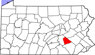
This is a list of the National Register of Historic Places listings in Dauphin County, Pennsylvania.

<span class="mw-page-title-main">National Register of Historic Places listings in Lancaster, Pennsylvania</span>

This is a list of the National Register of Historic Places listings in Lancaster, Pennsylvania.

<span class="mw-page-title-main">National Register of Historic Places listings in Adams County, Pennsylvania</span>

This is a list of the National Register of Historic Places listings in Adams County, Pennsylvania.

<span class="mw-page-title-main">National Register of Historic Places listings in Bedford County, Pennsylvania</span>

This is a list of the National Register of Historic Places listings in Bedford County, Pennsylvania.

<span class="mw-page-title-main">National Register of Historic Places listings in Blair County, Pennsylvania</span>

This is a list of the National Register of Historic Places listings in Blair County, Pennsylvania.

<span class="mw-page-title-main">National Register of Historic Places listings in Butler County, Pennsylvania</span>

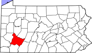
This is a list of the National Register of Historic Places listings in Butler County, Pennsylvania.

<span class="mw-page-title-main">National Register of Historic Places listings in Cambria County, Pennsylvania</span>

This is a list of the National Register of Historic Places listings in Cambria County, Pennsylvania.

<span class="mw-page-title-main">National Register of Historic Places listings in Centre County, Pennsylvania</span>

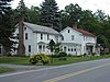
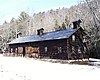
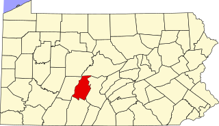
This is a list of the National Register of Historic Places listings in Centre County, Pennsylvania.

<span class="mw-page-title-main">National Register of Historic Places listings in Cumberland County, Pennsylvania</span>

This is a list of the National Register of Historic Places listings in Cumberland County, Pennsylvania.

<span class="mw-page-title-main">National Register of Historic Places listings in Lackawanna County, Pennsylvania</span>

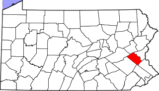
This is a list of the National Register of Historic Places listings in Lackawanna County, Pennsylvania.

<span class="mw-page-title-main">National Register of Historic Places listings in Lebanon County, Pennsylvania</span>

This is a list of the National Register of Historic Places listings in Lebanon County, Pennsylvania.

<span class="mw-page-title-main">National Register of Historic Places listings in Lehigh County, Pennsylvania</span>

This is a list of the National Register of Historic Places listings in Lehigh County, Pennsylvania.

<span class="mw-page-title-main">National Register of Historic Places listings in Northumberland County, Pennsylvania</span>

This is a list of the National Register of Historic Places listings in Northumberland County, Pennsylvania.

<span class="mw-page-title-main">National Register of Historic Places listings in Snyder County, Pennsylvania</span>

This is a list of the National Register of Historic Places listings in Snyder County, Pennsylvania.

<span class="mw-page-title-main">National Register of Historic Places listings in Westmoreland County, Pennsylvania</span>

This is a list of the National Register of Historic Places listings in Westmoreland County, Pennsylvania.

References

  1. The latitude and longitude information provided in this table was derived originally from the National Register Information System, which has been found to be fairly accurate for about 99% of listings. Some locations in this table may have been corrected to current GPS standards.
  2. National Park Service, United States Department of the Interior, "National Register of Historic Places: Weekly List Actions", retrieved December 8, 2023.
  3. 1 2 Numbers represent an alphabetical ordering by significant words. Various colorings, defined here, differentiate National Historic Landmarks and historic districts from other NRHP buildings, structures, sites or objects.
  4. The eight-digit number below each date is the number assigned to each location in the National Register Information System database, which can be viewed by clicking the number.
  5. Location derived from its NRHP nomination form; the NRIS lists the site as "Address Restricted"
  6. "Fire damages three homes, Pocono Historical Site". The Scranton Times-Tribune . June 7, 1980. p. 3. Retrieved August 21, 2022 via Newspapers.com.
  7. "Two charged in Pike arson". The Scranton Tribune . November 23, 1994. p. A6. Retrieved August 21, 2022 via Newspapers.com.