Johnston Atoll is an unincorporated territory of the United States, administered by the United States Fish and Wildlife Service (USFWS). It is a National Wildlife Refuge and part of the Pacific Remote Islands Marine National Monument. It is closed to public entry, and limited access for management needs is only granted by letter of authorization from the United States Air Force and a special use permit from the U.S. Fish and Wildlife Service.

Quonset Point, also known simply as Quonset, is a small peninsula in Narragansett Bay in the town of North Kingstown, Rhode Island. Its name is widely known from the Quonset hut, which was first manufactured there. Quonset is an Algonquian word meaning "small, long place".

Naval Air Station Alameda was a United States Navy Naval Air Station in Alameda, California, on San Francisco Bay.

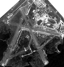
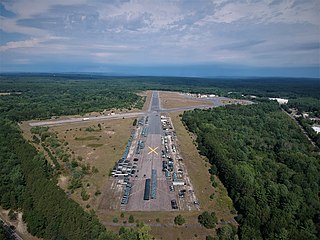
Quonset State Airport is a joint civil-military public airport located on Quonset Point, in northeastern North Kingstown, Rhode Island, United States, adjacent to Narragansett Bay. It is a general aviation airport and there is no scheduled airline service available. It is included in the Federal Aviation Administration (FAA) National Plan of Integrated Airport Systems for 2017–2021, in which it is categorized as a regional general aviation facility.

Davisville is a village in the town of North Kingstown in the U.S. state of Rhode Island that was formerly the home of the Davisville Naval Construction Battalion Center, which housed the United States Navy's SeaBees.
Fall River Municipal Airport was in Fall River, Massachusetts built between 1946 and 1951. The airport closed on February 18, 1996. The FAA deemed the airport unsafe due to a large landfill next to the airport, causing many seagulls, which disrupted airport operations. Its FAA code was FLR. The site of the airport is now an industrial park.

Quonset Point Air National Guard Station is the home base of the Rhode Island Air National Guard 143rd Airlift Wing. Naval Air Station (NAS) Quonset Point was a United States Naval Base in Quonset Point, Rhode Island that was deactivated in 1974. Next to NAS Quonset Point was Camp Endicott at Davisville, home of the Naval Construction Battalions known as the Seabees. Quonset Point also gave its name to the Quonset hut, a standardized temporary structure used by the U.S. military starting in World War II. Former US President Richard M. Nixon went through basic naval officer training at Quonset Point in 1942.
Moore Army Airfield is a former airfield located in Fort Devens, Massachusetts. It was closed following the closure of the fort in 1995. It is named for Ayer native Chief Warrant Officer 2 Douglas Moore. It was the only Army Airfield named for someone killed in the Vietnam War. It is currently used for racing and State Police driver training.

Foster Cove Archeological Site, designated RI-CH-2 and later RI-16 in state surveys, is a prehistoric archaeological site in Charlestown, Rhode Island. Located within the Ninigret National Wildlife Refuge, it is a Native American habitation site dating to the Woodland Period. It was identified in 1974 during a survey of the former Naval Auxiliary Air Station Charlestown by state archaeologists, in which two trenches included finds from the site. Test pits were dug in 1979 by the state to determine the extent of the site.
Naval Auxiliary Air Facility Nantucket was a United States Navy facility located in Nantucket, Massachusetts operational from 1942 to 1945. It existed as an auxiliary air facility of Naval Air Station Quonset Point.
Royal Air Force Condover or more simply RAF Condover is a former Royal Air Force Flying Training Command airfield and air navigation training establishment between August 1942 and June 1945, unusually for both fighter and bomber crews at different times. Located on the southern outskirts of Condover village in Shropshire, 4.9 miles (7.9 km) south of the county town Shrewsbury.
Naval Air Station DeLand was a United States Naval Air Station located in DeLand, Florida from 1942 to 1946. After the war, the airfield and associated infrastructure was redeveloped into DeLand Municipal Airport.

The Ninigret National Wildlife Refuge is a National Wildlife Refuge situated along the shore of Ninigret Pond. It is characterized by salt marshes, kettle ponds, freshwater wetlands, maritime shrub lands, and forests, and it is seasonally inhabited by over 250 species of birds. The area was originally used for farming, prior to being utilized in World War II as a Naval Auxiliary landing field. It was designated as a refuge in 1970 upon the transfer of 27.5 acres (11.1 ha) of land to the U.S. Fish and Wildlife Service. Subsequent transfers and purchases increased the protected area to approximately 900 acres (360 ha). During the winter months, black ducks, Canada geese, and diving ducks are especially prominent on the pond, while various species of migrating raptors are also common. Wildlife refuge staff also maintain a piping plover nesting program.

French Frigate Shoals Airport is a private use airport on Tern Island in French Frigate Shoals, a coral atoll, in Hawaii, United States. It is owned by the United States Fish and Wildlife Service, as part of the Hawaiian Islands National Wildlife Refuge.
Rhode Island National Wildlife Refuge Complex is a National Wildlife Refuge complex in the state of Rhode Island. Its headquarters is in Charlestown, Rhode Island. Dotted along the Rhode Island's Atlantic coastline, the five refuges that make up the complex offer a wide variety of natural settings.
NASA Crows Landing Airport is a private use airport owned by the NASA Ames Research Center, 1 nautical mile northwest of the central business district of Crows Landing, in Stanislaus County, California, United States. The airfield was formerly named Naval Auxiliary Landing Field Crows Landing or NALF Crows Landing when operated by the U.S. Navy. In January 2011, Airport-data.com reported the airport status as closed permanently. In March 2022, Stanislaus County announced the former airfield would be redeveloped into a business park.
Naval Outlying Landing Field Barin is a United States Navy airfield located in Foley, a city in Baldwin County, Alabama, United States.

Victorville Army Airfield auxiliary fields were four airfields used during World War II to support the Victorville Army Airfield pilot training near Victorville, California, and Adelanto, California. After the war the Victorville Army Airfield was renamed George Air Force Base on January 13, 1948. The airfields were built in 1941 by the United States Army Air Corps just before the war. Victorville Army Airfield covered 2,200-acre in the Mojave Desert. The US Army held a groundbreaking ceremony on 12 July 1941. The base, called Victorville Army Flying School, was ready to use before the attack on Pearl Harbor on December 7, 1941. The Army built four runways in a triangle configuration, with one runway down the middle of the triangle. Seven hangars were built to support operation. On April 23, 1943, the base was renamed Victorville Army Airfield.

Naval Air Station Livermore has nearby airfield landing strips to support the training of US Navy pilots during World War 2. The airfield are called Naval Outlying Landing Field (NOLFs). For the war many new trained pilots were needed. The Naval Outlying Landing Fields provided a place for pilots to practice landing and take off without other air traffic. The remotes sites offered flight training without distractions. Most of the new pilots departed to the Pacific War after training. The Outlying Landing Fields had little or no support facilities. Naval Air Station Livermore opened in 1942 and closed in 1951. The Outlying field closed in 1945, having completed the role of training over 4000 new pilots. To open the needed Outlying Landing Fields quickly, the Navy took over local crop dusting and barnstorming airfields.

Sweetwater Dam Naval Outlying Landing Field was a airfield near Naval Auxiliary Air Station Brown Field and Naval Air Station North Island used to support the training of US Navy pilots during World War 2. The runway built in 1944 was located in what is now a neighborhood 8 mile east of San Diego, California. The Navy support airfields are called Naval Outlying Landing Field (NOLF). For the war, many new trained pilots were needed. The Naval Outlying Landing Field provided a place for pilots to practice landing and take off without other air traffic. Sweetwater Dam site offered flight training without distractions. Most of the new pilots departed to the Pacific War after training. The Sweetwater Dam Outlying Landing Field had no support facilities. After the war the Outlying field closed in 1946, having completed the role of training new pilots. Sweetwater Dam Naval Outlying Landing Field and Sweetwater Carrier Landing Strip. The Landing Field had a single 3,000-foot east/west asphalt runway. The Navy leased 135.45 acres of grassland from Rancho de la Nación for the Landing Field. In 1949 the runway became a private civil airport, the Sweetwater Dam Airport also called the Paradise Mesa Airstrip. The Airport is named after the nearby Sweetwater Dam that makes the Sweetwater Reservoir. The Airport closed in 1951 and the runway became home to the Paradise Mesa Drag strip. The Carlsbad, California's Oilers Club help start the drag strip with the first meet on March 11, 1951. At its peak, 25 clubs were using the strip. The drag strip closed in 1959. Houses were built on the site, now called Paradise Hills and no trace of the runway can be found today. Part of the site is also the Daniel Boone Elementary School.