Navigational aid

Last updated
The entrance to the inner harbour of the Port of Fremantle, Australia, with a yellow special mark at left, a region A red port lateral mark at right, and a region A green starboard lighthouse in the background Quokka 1, Fremantle, 2020 (06).jpg
The entrance to the inner harbour of the Port of Fremantle, Australia, with a yellow special mark at left, a region A red port lateral mark at right, and a region A green starboard lighthouse in the background

A navigational aid (NAVAID), also known as aid to navigation (ATON), is any sort of signal, markers or guidance equipment which aids the traveler in navigation, usually nautical or aviation travel. Common types of such aids include lighthouses, buoys, fog signals, and day beacons.

Contents

Definition

According to the glossary of terms in the United States Coast Guard Light list, an aid to navigation (ATON) is any device external to a vessel or aircraft specifically intended to assist navigators in determining their position or safe course, or to warn them of dangers or obstructions to navigation.

Lateral marks

Region B green port lateral marks (with Galapagos sea lions (Zalophus wollebaeki)) in the Galapagos Islands Galapagos sea lions 02.jpg
Region B green port lateral marks (with Galápagos sea lions (Zalophus wollebaeki)) in the Galápagos Islands

Lateral marks indicate the edge of the channel. The standards are defined by the International Association of Marine Aids to Navigation and Lighthouse Authorities (IALA). Approaching harbour port a vessel leaves port hand marks to port (left) and starboard hand marks to starboard (right). Port hand marks are cylindrical, starboard marks are conical. If the mark is a pillar or spar shape, then a topmark is fitted which is either cylindrical or conical as appropriate. [1]

IALA divides the world into two regions: A and B. Region B is the Americas (excluding Greenland) along with Japan, Korea and the Philippines. Region A is the rest of the world. In region A port marks are red and starboard marks green. In region B port marks are green and starboard red. [1] Where marks are numbered red marks have even numbers and green marks have odd numbers. [2]

Preferred channel marks

Where a channel divides the mark at the junction is called a "preferred channel mark" or "junction buoy". The mark has the colour and shapes corresponding to the preferred channel with a band of the other colour to indicate it is the other hand mark for the subsidiary channel. [1] In IALA region A where a minor channel branches off to port the mark at the junction would be a red cylinder with a green band. The red cylinder is a port hand mark for the main channel, the green band indicates a starboard mark for the minor channel. [3] In IALA region B the colours (but not shapes) are reversed. [4]

Cardinal marks

Cardinal marks warn of a danger (wrecks, shoals, bends, spits etc.) and indicate the safe water past the danger. There are four varieties: north, east, south and west. A north cardinal mark is placed to the north of a hazard and indicates safe water is to the north of the mark. East, south and west are placed accordingly. Cardinal marks are yellow and black with two cones at top marks. There is no difference between IALA region A and B. [5]

Other IALA defined marks

Isolated danger mark

Black with a horizontal red band and two black balls as a top mark. The mark indicates a danger (shoal, rock, wreck etc.) which is isolated with safe water all around. [6]

Safe water mark

Red and white vertical stripes with a single red sphere for a top mark. It indicates that there is safe water all around it. The usual use is to indicate the start of a channel or port approach. [6]

New danger

Indicates a newly discovered or created danger that is not yet marked on charts (or in update notices thereto). The mark is used for a short time until the danger is either removed or else marked conventionally with lateral or cardinal marks. The mark has blue and yellow vertical stripes and a yellow and blue light. The topmark is a vertical yellow cross. [7]

Special marks

Yellow with an "X" topmark. Used to mark other features such as swimming areas, anchorages, pipelines. The exact reason is marked on charts. [8]

Sector lights

A sector light is one which shows different colours depending upon the angle of approach. They are commonly used to indicate the safe channel (white) and show red or green if the vessel is out of the safe channel. IALA requires the light colours to follow the appropriate region (A or B) colour scheme. [9]

Other markers

Diagram showing lateral, non-lateral, and special purpose markers as seen on an IALA Region B nautical chart. ATON - Road Signs of the Waterway.png
Diagram showing lateral, non-lateral, and special purpose markers as seen on an IALA Region B nautical chart.

There are also other markers that give information other than the edges of safe waters. Most are white with orange markings and black lettering. They are used to give direction and information, warn of hazards and destructions, mark controlled areas, and mark off-limits areas. These ATONs do not mark traffic channels.

On non-lateral markers, there are some shapes that show certain things:

Squares [10]
show information, including places to find food, supplies, and repairs. They sometimes show directions.
Diamonds [10]
warn about dangers like rocks, construction, dams, or stumps.
Circles [10]
mark a controlled area such as no wake, idles speed, speed limit, or ski zone.
Crossed diamonds [10]
show areas off limits to all boats, like swimming areas and dams.

AIS AtoNs

AtoNs can be integrated with automatic identification system (AIS). AIS transmitted form an actual aid (buoy, lighthouse etc.) is termed a "real AIS AtoN". [11]

If it is impractical to equip the AtoN with an AIS transponder an AIS shore station can be assigned to transmit AIS messages on behalf of the AtoN. This is known as a "synthetic ATON". Synthetic AtoNs can be either "monitored synthetic AtoNs" or "predicted synthetic AtoNs". The former have a link between the AtoN so that the AIS station can confirm the AtoNs status. The latter have no link and the AIS system just predicts that the AtoN is where it should be. [12]

If there is no real AtoN (such as for the short term marking of a wreck) then a "virtual AIS AtoN" is used. [12]

Each AIS AtoN must have a unique Maritime Mobile Service Identity (MMSI) number. Synthetic and virtual AIS AtoNs mark their messages as repeats to indicate that the location of the transmitter is not the location of the AtoN. [13]

Lead marks and lights

Triangle shaped lead marks with lights. Navigation leading markers and lights.JPG
Triangle shaped lead marks with lights.

Lead marks (as in "leading a ship into a safe place") and lights are fixed markers that are laterally displaced to allow a mariner to navigate a fixed channel along the preferred route. They are also known as "channel markers". [14] [ failed verification ] They can normally be used coming into and out of the channel. When lit, they are also usable at night. Customarily, the upper mark is up-hill from the lower (forward) mark. The mariner will know the geometry of the marks/lights from the navigational chart and can understand that when "open" (not one above the other) the ship needs to be navigated to "close" the marks (so one is above the other) and be in the preferred line of the channel.

In some cases, the lead marks/lights are provided by lasers, as in the laser channel under the Tasman Bridge on the Derwent River at Hobart, Tasmania.

See also

large buoy in storage, Homer, Alaska Bigbuoy.jpg
large buoy in storage, Homer, Alaska

Notes

  1. 1 2 3 IALA (1 June 2017), Maritime buoyage system and other aids to navigation (PDF), pp. 10–11, retrieved 23 October 2022
  2. IALA 2013, p. 9.
  3. IALA 2013, p. 22.
  4. IALA 2013, p. 23.
  5. IALA 2013, pp. 14–15.
  6. 1 2 IALA 2013, p. 16.
  7. IALA 2013, p. 18.
  8. IALA 2013, p. 17.
  9. IALA 2013, p. 19.
  10. 1 2 3 4 "U.S. Aids To Navigation System" (PDF). United States Coast Guard, Office of Boating Safety. Retrieved July 26, 2023.
  11. IALA (June 2011), Recommendation A-126 on the use of the Automatic Identification System (AIS) in marine aids to navigation (1.5 ed.), Saint Germain en Laye, France, p. 10, archived from the original on 23 January 2021, retrieved 29 June 2019{{citation}}: CS1 maint: location missing publisher (link)
  12. 1 2 IALA 2011, p. 11.
  13. IALA 2011, pp. 11–12.
  14. Silk, Robert (March 10, 2010). "Channel marker proposal upsets anglers". keysnews.com. Key West, Florida: The Citizen. Archived from the original on July 13, 2011. Retrieved December 2, 2010.

Further reading

Related Research Articles

<span class="mw-page-title-main">Trinity House</span> Official authority for lighthouses in England

The Corporation of Trinity House of Deptford Strond, also known as Trinity House, is the official authority for lighthouses in England, Wales, the Channel Islands and Gibraltar. Trinity House is also responsible for the provision and maintenance of other navigational aids, such as lightvessels, buoys, and maritime radio/satellite communication systems. It is also an official deep sea pilotage authority, providing expert navigators for ships trading in Northern European waters.

<span class="mw-page-title-main">Buoy</span> Floating structure or device

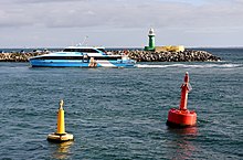
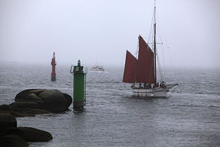
A buoy is a floating device that can have many purposes. It can be anchored (stationary) or allowed to drift with ocean currents.

The International Association of Marine Aids to Navigation and Lighthouse Authorities (IALA), previously known as International Association of Lighthouse Authorities, is an intergovernmental organization founded in 1957 to collect and provide nautical expertise and advice. IALA is also known by its French name of Association Internationale de Signalisation Maritime (AISM).

<span class="mw-page-title-main">Lateral mark</span> Sea mark marking the edge of a channel

A lateral buoy, lateral post or lateral mark, as defined by the International Association of Marine Aids to Navigation and Lighthouse Authorities, is a sea mark used in maritime pilotage to indicate the edge of a channel.

<span class="mw-page-title-main">Sea mark</span> Maritime navigation aid

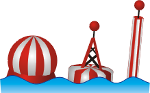
A sea mark, also seamark and navigation mark, is a form of aid to navigation and pilotage that identifies the approximate position of a maritime channel, hazard, or administrative area to allow boats, ships, and seaplanes to navigate safely.

<span class="mw-page-title-main">Sector light</span> Man-made pilotage and position fixing aid

A sector light is a man-made pilotage and position fixing aid that consists of strictly delineated horizontal angle light beams to guide water-borne traffic through a safe channel at night in reasonable visibility. Sector lights are most often used for safe passage through shallow or dangerous waters. This may be when leaving or entering harbour. Nautical charts give all the required information.

<span class="mw-page-title-main">Cardinal mark</span> Sea mark indicating where safe water is near to a hazard

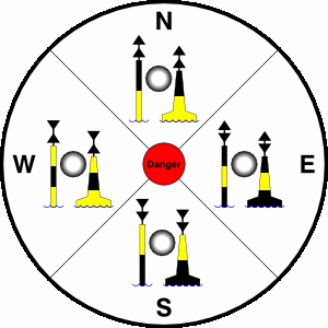
A cardinal mark is a sea mark used in maritime pilotage to indicate the position of a hazard and the direction of safe water.

<span class="mw-page-title-main">Safe water mark</span> Type of sea mark

A safe water mark, as defined by the International Association of Lighthouse Authorities, is a sea mark used in maritime pilotage to indicate the end of a channel. They usually imply that open, deep and safe water lies ahead. They are also used to indicate the start and end of a buoyed section of a continuous narrow channel; and a series of them may mark a safe route through shallow areas. It is therefore important to consult appropriate charts to determine their meaning in each location. They are also known as fairway buoys and clear water buoys.

<span class="mw-page-title-main">Isolated danger mark</span> Sea mark indicating a danger spot

An Isolated Danger Mark, as defined by the International Association of Lighthouse Authorities, is a sea mark used in maritime pilotage to indicate a hazard to shipping such as a partially submerged rock.

<span class="mw-page-title-main">Thames Estuary</span> Estuary in which the River Thames meets the waters of the North Sea

The Thames Estuary is where the River Thames meets the waters of the North Sea, in the south-east of Great Britain.

<span class="mw-page-title-main">Radar beacon</span> Transmitter-receiver associated with a fixed navigational mark

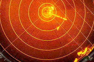
Radar beacon is – according to article 1.103 of the International Telecommunication Union's (ITU) ITU Radio Regulations (RR) – defined as "A transmitter-receiver associated with a fixed navigational mark which, when triggered by a radar, automatically returns a distinctive signal which can appear on the display of the triggering radar, providing range, bearing and identification information." Each station shall be classified by the service in which it operates permanently or temporarily.

MV Tricolor was a 50,000 tonne Norwegian-flagged vehicle carrier built in 1987, notable for having been involved in three English Channel collisions within a fortnight.

<span class="mw-page-title-main">Automatic identification system</span> Automatic tracking system that uses transceivers on ships

The automatic identification system (AIS) is an automatic tracking system that uses transceivers on ships and is used by vessel traffic services (VTS). When satellites are used to receive AIS signatures, the term Satellite-AIS (S-AIS) is used. AIS information supplements marine radar, which continues to be the primary method of collision avoidance for water transport. Although technically and operationally distinct, the ADS-B system is analogous to AIS and performs a similar function for aircraft.

<span class="mw-page-title-main">Day beacon</span> Unlighted nautical sea mark

A day beacon is an unlighted nautical sea mark. A signboard identifying it is called a day mark. Day beacons typically mark channels whose key points are marked by lighted buoys. They may also mark smaller navigable routes in their entirety. They are the most common navigation aid in shallow water, as they are relatively inexpensive to install and maintain. Navigation around them is similar to that around other navigation aids.

USCGC <i>Mobile Bay</i> United States Coast Guard icebreaker

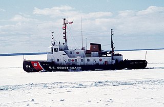
USCGC Mobile Bay (WTGB-103) is an active icebreaking tug under the direction of the United States Coast Guard. Her homeport is located in Sturgeon Bay, Wisconsin. She is one of two ships in her class that has been equipped with a 120-foot (37 m) aids-to-navigation (ATON) barge operating on the Great Lakes. The vessel was specifically designed to carry out icebreaking missions, but also carries out missions in Search and Rescue, Environmental Pollution Response, Maritime Law Enforcement and Homeland Security.

USCGC <i>Woodrush</i> Buoy tender

USCGC Woodrush (WLB-407) was a buoy tender that performed general aids-to-navigation (ATON), search and rescue (SAR), and icebreaking duties for the United States Coast Guard (USCG) from 1944 to 2001 from home ports of Duluth, Minnesota and Sitka, Alaska. She responded from Duluth at full speed through a gale and high seas to the scene of the SS Edmund Fitzgerald sinking in 1975. In 1980, she took part in a rescue rated in the top 10 USCG rescues when she helped to save the passengers and crew of the cruise ship Prinsendam after it caught fire in position 57°38"N 140° 25"W then while being towed sank off Graham Island, British Columbia. She was one of the first vessels to respond to the Exxon Valdez oil spill in 1989. She was decommissioned on 2 March 2001 and sold to the Republic of Ghana to serve in the Ghana Navy.

Enhanced radar positioning is a proposal for a position fixing system in maritime navigation, based on radar navigation. It is the automation of the process of determining own position by means of radar fixing, using a multitude of objects with known position as reference.

<span class="mw-page-title-main">North Bull Lighthouse</span> Lighthouse

The North Bull Lighthouse, is an active aid to navigation located at the mouth of the River Liffey, near Dublin, Ireland. It is one of four lighthouses that help guide shipping into the Liffey, and the Port of Dublin, all of which are operated and maintained by the Dublin Port Company.

USCGC <i>Walnut</i> (WLM-252)

The USCGC Walnut (WLM-252) was a steel-hulled, steam-powered twin-screw Hollyhock-class tender built for the Lighthouse Service in 1939 at Oakland, California. With the transfer of the Lighthouse Service to the Coast Guard in June, 1939, she was commissioned as a Coast Guard cutter on 8 July 1939.

<span class="mw-page-title-main">Emergency wreck buoy</span> Marker buoy warning of a wreck

An Emergency wreck buoy is used to warn of a new wreck which has not yet been listed in maritime documents. The buoy is expected to be deployed for the first 24-72 hours after the wreck occurs. After that time more permanent buoyage should be deployed and charts updated.